Location: 40 km (24 mi) South of E87 highway to Geyre Map
Tel. (0256) 448 80 86
Open: 9am- 6pm daily
9am- 7pm daily
summer
Entrance Fee: 10 TL
Aphrodisias is one of the most
impressive and best-preserved ancient cities in Turkey, located in
the fertile upper valley of the Morsynus River in the historical
region of Caria, southwestern Anatolia (near the modern village of
Geyre, about 100 km inland from the Aegean coast).
It was
inscribed as a UNESCO World Heritage Site in 2017 (along with its
nearby marble quarries), recognized for its exceptional marble
architecture, sculpture tradition, and the unique cult of Aphrodite
that blended local Anatolian, Greek, and Roman elements.
The city
was founded as a Hellenistic city-state in the early 2nd century BC
on the site of an earlier sanctuary, but it flourished most under
Roman rule from the 1st century BC onward. Its wealth came from
high-quality local white and blue-gray marble quarries and a
renowned school of sculptors whose works were exported across the
Roman Empire. Aphrodisias enjoyed special privileges (autonomy and
tax exemption) granted by Julius Caesar and Augustus due to its
devotion to Aphrodite (whom Romans linked to their ancestress
Venus). It later became the capital of the Roman province of Caria
before declining after earthquakes and invasions in the 7th century
AD, eventually being renamed Stavropolis and then Caria.
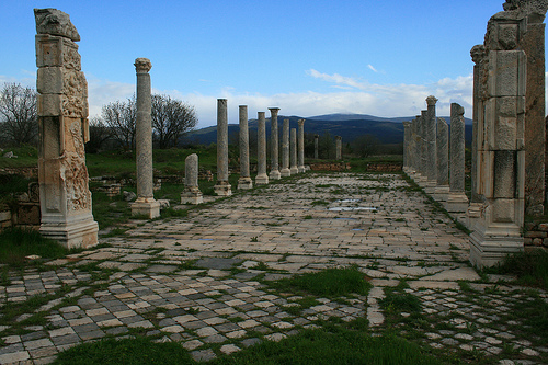
The site
features an orthogonal street grid with massive civic structures
built almost entirely of marble. Many buildings are remarkably
intact, offering a vivid picture of a prosperous Roman provincial
city. Below is an in-depth look at its major landmarks.
1. Tetrapylon (Monumental Gateway)
This is often the first major
structure visitors encounter and one of the site’s most iconic and
photogenic landmarks. Built around AD 200, the Tetrapylon served as a
grand four-sided monumental gateway (tetra = four, pylon = gate) marking
the transition from the secular main north-south street into the sacred
precinct of the Temple of Aphrodite.
It features 12 towering columns
(originally 16) with ornate Corinthian capitals, fluted shafts (some
spirally fluted), and elaborate pediments decorated with reliefs of
gods, victories, and mythological scenes carved by the city’s master
sculptors. The structure was partially reconstructed in the 20th century
using original pieces, giving a striking sense of its original grandeur.
It symbolizes the city’s artistic prowess and welcoming of pilgrims and
visitors.
2. Temple of Aphrodite
The spiritual and physical
heart of the city, this temple originated in the 3rd century BC as a
sanctuary to a local fertility goddess syncretized with the Greek
Aphrodite. It was massively expanded in the late 1st century BC/early
1st century AD into a grand peripteral Ionic temple (surrounded by a
single row of columns: 8 across the front and back, 13 along the sides).
Today, 14 towering columns (some re-erected) still stand amid the ruins,
along with fragments of the cella (inner chamber) that once housed the
famous cult statue of Aphrodite of Aphrodisias—a distinctive local
depiction blending Greek and Anatolian styles. Around AD 500, the temple
was uniquely converted into a Christian basilica through sophisticated
engineering that preserved much of the structure while transforming it.
This conversion is considered unparalleled in the ancient world for its
technical ingenuity and symbolic shift from pagan to Christian worship.
3. Stadium
One of the most spectacular and best-preserved ancient
stadiums in the entire Mediterranean, this is a must-see landmark. Built
in the 1st century AD, it measures approximately 270 m long by 60 m wide
(with a track of ~225 m x 30 m) and could seat up to 30,000 spectators
on 30 rows of marble seats. Its slightly elliptical (“amphitheatral”)
ends improved visibility for all.
Originally used for athletic
contests (foot races, wrestling, etc.), it later hosted gladiatorial and
wild-animal events after the theatre was damaged by earthquakes. The
seating is exceptionally intact, and the structure’s scale and
preservation make it feel almost ready for use today—one of the largest
and most complete examples of its kind anywhere.
4. Sebasteion
(Augusteum)
This extraordinary 1st-century AD imperial cult complex
was jointly dedicated to Aphrodite, the “Divine Augusti” (Roman
emperors, especially the Julio-Claudian dynasty), and the People. It
consisted of a long processional courtyard flanked by three-story
porticoes on both sides, richly decorated with nearly 200 life-size
marble relief panels.
The reliefs (many now in the on-site museum)
depict Roman emperors as gods, mythological heroes, personifications of
conquered provinces and peoples, and allegorical scenes—providing
unparalleled insight into how Roman imperial power was visualized and
legitimized locally in the Greek East. The fusion of Hellenistic, Roman,
and local Aphrodisian artistic styles is masterful. The complex
highlights the city’s close political ties to Rome.
5. Theatre
Nestled on the slope of an ancient settlement mound, the theatre dates
to the late Hellenistic period (c. 30–27 BC) and was financed by the
wealthy benefactor Gaius Julius Zoilos. It seated 7,000–8,000 people and
features a well-preserved cavea (seating area), stage building with an
ornate aediculated façade, and a skene that was later modified for Roman
spectacles.
An important “archive wall” near the stage preserves
dozens of imperial letters and documents inscribed in marble, offering
rare historical records of the city’s privileges under Roman emperors.
6. Other Notable Landmarks
Bouleuterion (Council House/Odeon): A
semicircular indoor assembly hall near the North Agora, with tiered
marble seating for about 1,750 people. It served as the city council’s
meeting place and also hosted concerts and performances.
Hadrianic
Baths (2nd century AD): A large public bathing complex with
well-preserved halls, pools, and marble fittings—typical of Roman civic
luxury.
Agoras: The North and South Agoras were major civic plazas
for markets, gatherings, and public life; the South Agora included a
large ornamental pool.
City Walls and Grid: The site is enclosed by
3.5 km of walls enclosing about 5 square km, with streets laid out in a
clear orthogonal grid.
Aphrodisias Museum
No visit is complete
without the excellent on-site museum, which houses thousands of marble
sculptures, reliefs (especially from the Sebasteion), and the original
cult statue of Aphrodite. It showcases the city’s world-famous
sculptural school at its finest.
Best Time to Visit
Spring (March–June) and fall
(September–November): Ideal with mild temperatures (20–25°C/68–77°F),
blooming landscapes, and fewer crowds. Late April or early October is
optimal for comfortable exploration.
Summer: Very hot and sunny;
visit early morning or late afternoon to avoid peak heat. The site can
feel exposed with limited shade.
Winter: Cooler and quieter, but
shorter hours and potential rain. Still viable if you dress
appropriately.
Aim for weekdays or early arrival (site opens around
8:30–9:00 AM) to enjoy it nearly alone, especially outside peak season.
Visitor numbers remain low compared to more famous sites (around 50,000
annually in recent years).
How to Get There
Private car or
rental is by far the easiest and most flexible option:
From
Pamukkale/Denizli: ~1.5–2 hours via the southern route through Tavas
(stop at Laodicea en route).
From Kuşadası/Selçuk (Ephesus): ~2.5
hours via Aydın and Nazilli.
From İzmir: Similar, around 2.5–3 hours.
Roads are generally good (D585 highway). Parking is available at the
site.
Public transport is possible but time-consuming and
requires patience:
Bus/train to Nazilli or Denizli, then dolmuş
(minibus) to Karacasu, then another to Geyre/dörtyol crossroads near the
site entrance.
Total one-way from Pamukkale can take 3–4+ hours with
connections. Taxi from Denizli or Nazilli is a practical hybrid.
Organized tours: Available from Pamukkale, Kuşadası, or even Istanbul
(with flights). Private tours with a guide are highly recommended for
deeper insight, as the site benefits greatly from context about its
sculptures and history. Day trips often combine it with Laodicea or
other sites.
Tickets, Hours, and Practicalities
Opening hours:
Typically 8:30/9:00 AM to 7:00 PM (summer) or 5:00–6:00 PM (winter).
Last entry ~1 hour before closing. Confirm locally as they can vary.
Ticket: Combined site + museum (prices fluctuate; check current rates
on-site or via apps like Museum Pass). The Turkish Museum Pass (15-day)
includes it and saves money for multi-site visitors.
Museum:
Excellent and essential—do not skip it. It houses world-class
sculptures, reliefs (including from the Sebasteion), sarcophagi, and the
cult statue of Aphrodite. Note: It has occasionally undergone
restoration; verify status.
Facilities: Limited on-site (cafes/snacks
nearby in Geyre or Karacasu). Toilets available. No audio guides
mentioned universally, but guided tours enhance the visit.
Time
needed: 2–4 hours for the site + 1 hour for the museum. Allow a full
half-day to wander without rushing.
Site Highlights and Suggested
Itinerary
The site is large and flat-ish with good paths, but expect
significant walking (several km total). A logical loop often starts near
the entrance/museum:
Tetrapylon — Iconic monumental gateway with
restored columns; stunning photo spot.
Temple of Aphrodite (later
basilica) — Heart of the city, with mountain views.
Sebasteion —
Remarkable imperial cult complex with incredible reliefs (many in the
museum).
Stadium — One of the best-preserved anywhere (270m long,
seated ~30,000); jaw-dropping scale.
Bouleuterion (Odeon/Council
House), Agoras, Hadrian’s Baths, Theatre, and Bishop’s Palace — Explore
civic, bathing, and later Christian layers.
City Walls and other
structures for context.
End or start with the museum for sculptures
that bring the ruins to life. A walking trail circles parts of the site.
Visiting Tips
What to wear/bring:
Comfortable, sturdy walking
shoes (uneven marble, dust, grass).
Light, breathable layers; sun
hat, sunglasses, sunscreen (exposed site).
Modest clothing if
combining with other Turkish sites (shoulders/knees covered for any
religious spots, though not strictly needed here).
Water bottle
(refillable), snacks, light rain jacket if uncertain weather.
Camera/binoculars for details.
Health/Safety: Stay hydrated.
Watch for uneven surfaces. Site is generally safe and family-friendly,
but strollers are challenging. No major restrictions, but respect rules
(no touching artifacts).
Enhance the experience: Hire a local guide
(especially for sculpture/history context). Visit early/late to avoid
any groups and enjoy golden light. Combine with nearby Laodicea (another
ancient site) or Pamukkale for a full day.
Food & Stay: Simple
eateries in Geyre (e.g., köfte/meatballs at local spots). Stay in
Pamukkale (more amenities) or nearby hotels like Anatolia Hotel Geyre
for convenience. Karacasu has more options.
Other notes: Less
touristy than Ephesus, so fewer hawkers. Support local by buying from
village shops if interested. Photography is generally allowed (check for
restrictions on flashes/tripods).
Aphrodisias (modern Turkish: Afrodisyas) is one of the best-preserved
and most illuminating ancient cities of the Greco-Roman world, located
in the fertile upper valley of the Morsynus River (modern Dandalas) in
the historic region of Caria, southwestern Turkey, about 100 km inland
from the Aegean coast near the modern village of Geyre (Aydın Province).
Its ruins—along with the adjacent marble quarries—were inscribed on the
UNESCO World Heritage List in 2017 for their exceptional testimony to
urban planning, sculptural production, religious syncretism, and the
transition from pagan to Christian antiquity. The site’s wealth derived
from nearby high-quality white and blue-gray Carian marble quarries and
the renowned school of sculptors it supported, whose works were exported
across the Roman Empire. Over 2,000 inscriptions, excavated sculptures,
and monuments provide an unusually detailed picture of social,
political, and artistic life.
Prehistory and Early Settlement (c.
5800 BCE–3rd century BCE)
Human activity in the area dates back to
the Late Neolithic/Chalcolithic period (around 5800–5000 BCE), with
evidence of settlements on two low mounds (including the later acropolis
and Pekmez Hüyük). The region’s fertile soils, reliable water sources,
and strategic location supported early communities. By the 7th–6th
centuries BCE, a rural sanctuary dedicated to a local Anatolian
fertility/mother goddess had developed here. This cult figure—often
linked to broader Near Eastern traditions like Ishtar or the Ephesian
Artemis—later syncretized with the Greek goddess Aphrodite. Early Greek
names for the settlement included Lelégōn Pólis (“City of the Leleges”),
Megálē Pólis (“Great City”), and Ninóē. The distinctive cult image of
Aphrodite of Aphrodisias, depicted as a standing, richly adorned
fertility figure with a mural crown and cosmic reliefs (Charites, Gaia,
Helios, etc.), originated in the Archaic period or earlier and became
the city’s defining symbol.
Hellenistic Founding and Rise
(3rd–1st centuries BCE)
The Temple of Aphrodite was constructed in
the 3rd century BCE, and around the early 2nd century BCE—during a wave
of urbanization in the Maeander Valley—the site was formally laid out as
a planned Greek polis (city-state) with an orthogonal street grid. Only
a few structures, like the temple itself, deviated from this grid.
Aphrodisias quickly became the metropolis (regional capital) of Caria.
Its name derived directly from Aphrodite, emphasizing the goddess’s
central role. The city benefited from its sanctuary’s growing fame and
the proximity of marble quarries, which fueled early sculptural
production. Hellenistic Aphrodisias was already producing high-quality
marble works blending local Carian, Greek, and emerging Roman
influences.
Roman Period: Golden Age of Privilege and Artistic
Flourishing (1st century BCE–3rd/4th centuries CE)
Aphrodisias
reached its peak under Roman rule, particularly from the late Republic
through the High Empire. The city cultivated strong ties with Rome
through the shared cult of Aphrodite (identified with Venus, mother of
Aeneas and thus ancestral to the Julian family). It was favored by Sulla
(who gifted to the temple after the Mithridatic Wars), Julius Caesar,
and especially Augustus, who granted it autonomy, tax-exempt status, and
declared it “the one city from all of Asia that I have selected to be my
own.” These privileges, reaffirmed in inscriptions (including the famous
“Archive Wall” in the theatre), protected the city and attracted
benefactors.
Local freedman Gaius Julius Zoilos, a former slave of
Caesar freed by Octavian (Augustus), funded major civic buildings and
helped align the city politically. The economy boomed from marble
quarrying and the export of sculpture. Aphrodisias developed one of the
Roman world’s premier sculpture workshops (systematically excavated and
unique in its scale), producing virtuoso portraits, mythological
statues, sarcophagi, architectural reliefs (including “peopled
scrolls”), and imperial cult imagery. Sculptors signed their works and
were sought after in Rome, Constantinople, and provincial centers like
Sardis or Tivoli. The city’s cosmopolitan population—Greek, Roman,
Carian, with Jewish and later Christian communities—is richly documented
in inscriptions (including “God-fearers” supporting the synagogue).
Key monuments from this era include:
Temple of Aphrodite (core
3rd century BCE, expanded in Roman times): A large peripteral Ionic
temple housing the famous cult statue.
Sebasteion (1st century CE):
An elaborate imperial cult complex with two three-story porticoes
displaying reliefs of emperors, victories, and mythological scenes.
Tetrapylon (monumental gateway, c. 200 CE): A richly carved entrance to
the sanctuary.
Stadium (1st century CE): One of the best-preserved in
the ancient world (270 × 60 m, amphitheatral ends, seating ~30,000),
used for athletics, games, and later gladiatorial contests.
Theatre,
Odeon/Bouleuterion (~1,750 seats), Agora, baths (including Hadrian’s),
and houses—all lavishly decorated in local marble.
Population
likely peaked at 15,000–25,000. Aphrodisias also hosted philosophy
(e.g., Alexander of Aphrodisias) and remained a pagan stronghold longer
than many cities.
Late Antiquity and Christianization (4th–7th
centuries CE)
Christianity gradually took hold amid empire-wide
changes. The Temple of Aphrodite was converted into a cathedral around
AD 500 (under Emperor Zeno, c. 481–484, with unique engineering that
repurposed the structure dramatically). This occurred relatively late,
reflecting the city’s attachment to its patron goddess. The city was
renamed Stauropolis (“City of the Cross”) before 640 to erase pagan
associations, though it was later simply called Caria. It served as the
seat of a metropolitan bishopric (with numerous suffragan sees) and a
fiscal dioikesis. Sculptors continued producing high-quality imperial
portraits into the 6th century. However, earthquakes (notably in the 4th
century and a devastating one in the early 7th century) caused flooding
and structural collapse, shrinking the city to a small fortified
settlement around the theatre. Urban life and classical fabric largely
collapsed in the early 7th century amid broader Byzantine crises.
Byzantine Decline, Seljuk Conquests, and Abandonment (7th–13th
centuries CE)
Post-7th century, Aphrodisias/Stauropolis/Caria
survived as a reduced Byzantine center but suffered repeated raids after
the Battle of Manzikert (1071). It was sacked by rebel Theodore
Mankaphas (with Turkish support) in 1188 and again by Seljuks in 1197,
when much of the population was captured and relocated near Philomelion.
By the late 13th century, it fell permanently under Turkish control. The
site was largely abandoned, with a small Turkish village called Geyre (a
corruption of “Caria”) eventually occupying parts of the ruins. Nature
and later settlement buried much of the city.
Modern Discovery,
Excavations, and Preservation (18th century–present)
European
travelers noted the site from the 18th century onward. Formal
excavations began with French engineer Paul Augustin Gaudin (1904–1905),
who sent finds (friezes, capitals) to the British Museum. The
transformative phase started in 1961 under Turkish-American
archaeologist Kenan Erim (New York University), who excavated major
monuments over three decades. Since 1991, the project has been directed
by R.R.R. Smith (Oxford) with ongoing NYU collaboration (now also with
Oxford University) under the Turkish Ministry of Culture and Tourism.
The modern village of Geyre was relocated to allow full excavation.
Major discoveries include thousands of sculptures, inscriptions, and
workshops that reveal ancient sculptural techniques in unprecedented
detail. Drones, 3D mapping, and ongoing work continue to yield finds
(e.g., sarcophagi in 2020). The site and quarries form a protected
UNESCO property (152 ha core + buffer zone), emphasizing its role in
understanding Greco-Roman identity, imperial religion, artistic
production, and late antique religious transition. It remains one of
Turkey’s premier archaeological attractions, with an on-site museum
displaying highlights.
Regional and Precise Location
Aphrodisias lies in the historic
region of Caria (western Anatolia), within modern Aydın Province,
specifically in the Karacasu district near the village of Geyre (a small
Turkish settlement whose name derives from "Caria"). The archaeological
site sits at coordinates 37°42′30″N 28°43′25″E (approximately
37.70833°N, 28.72361°E).
It is situated roughly:
100 km (62 mi)
inland east from the Aegean Sea coast
230 km (140 mi) southeast of
İzmir
About 100 km east of Aydın city center
60–80 km west of
Denizli (via scenic routes like the D585 highway around mountain ranges)
This places it in the broader Büyük Menderes (Maeander) River basin,
one of western Turkey’s major river systems, but more precisely in the
upper valley of the Morsynus River (sometimes referred to in older
sources as the Dandalas River), a tributary that feeds into the
Maeander.
Topography and Landforms
The site occupies a gently
undulating fertile plateau and alluvial plain south of the main Maeander
River channel, at an elevation of approximately 500 m (1,640 ft) above
sea level. The landscape is dominated by the broad, flat-to-rolling
valley floor, ideal for agriculture, but punctuated by two low
prehistoric settlement mounds (tells or acropolis-like hills) dating
back to the Early Bronze Age (as early as ~2800 BCE). The larger mound
served as the foundation for key structures, such as the theatre, which
was built into its eastern slope.
To the northeast and east rises the
Babadağ (Baba Dağ) mountain range, whose lower slopes provided the raw
material for Aphrodisias’ fame. The city proper was enclosed by
well-preserved city walls approximately 3.5 km long, defining an area of
about 72 hectares. These walls followed the natural contours while
incorporating reused marble blocks. The orthogonal street grid
(north-south orientation, with blocks roughly 35.5 × 39 m) was laid over
this relatively flat terrain in the late Hellenistic period, integrating
the pre-existing sanctuary of Aphrodite and theatre.
The surrounding
countryside features fertile fields (historically and today supporting
crops like cotton), scattered cypress groves, and open agricultural land
with minimal modern intrusion—contributing to the site’s authentic,
“untouched” appearance.
Hydrology and Soils
The Morsynus River
and its tributaries create a rich, well-watered alluvial environment
with deep, fertile soils that supported intensive agriculture in
antiquity. Ancient sources and archaeology highlight the city’s
prosperity from this “rich and well-watered agricultural land.” The
river valley provided reliable water for irrigation, drinking, and baths
via aqueducts (including a notable long one called the Timeles).
However, the low-lying plain is vulnerable to seasonal flooding,
especially in winter. A major 4th-century earthquake raised the local
water table, leading to chronic flooding in parts of the town and
prompting ancient emergency plumbing modifications. Winter floods and
summer wildfires remain the primary natural risks today.
Geology
and Resources
Aphrodisias owed much of its economic and artistic
prominence to local marble quarries located about 1–4 km northeast of
the city walls, on the slopes of Babadağ. These yielded high-quality
white and blue-gray Carian marble, ideal for sculpture and monumental
architecture. The quarries form a second component of the UNESCO serial
property and were actively exploited from Hellenistic through Roman
times.
The region sits in a seismically active zone along tectonic
boundaries. Major earthquakes in the 4th and 7th centuries CE caused
widespread damage, altered hydrology, and contributed to the city’s
eventual decline.
Climate and Environmental Context
Aphrodisias experiences a classic Mediterranean (Aegean) climate:
Hot, dry summers (often exceeding 30–35°C/86–95°F, with intense
sun—visitors are advised to bring protection)
Mild, wetter winters
with higher precipitation and flood risk
Pleasant shoulder seasons
(spring and autumn) with blooming vegetation and moderate temperatures
The fertile valley supports lush vegetation in the wetter months,
while summer brings drier, golden landscapes prone to fire. The site’s
relative isolation in an agricultural valley has shielded it from modern
urbanization, preserving its ancient setting amid fields and low hills.
Modern Landscape and Preservation
Today, the ruins emerge
dramatically from cotton fields and cypress stands, with the modern
Geyre village relocated slightly to allow full excavation. The broader
landscape remains largely as it was in antiquity—rolling hills, fertile
plains, and the looming Babadağ backdrop—making Aphrodisias a pristine
example of how geography shaped (and was shaped by) an ancient city.