Location: East Thrace Map
Open: 8am- 5pm daily winter
9am- 6pm daily summer
Kabatepe Information Centre
Tel. (0286) 814 11 28
Open: 8:30am-
6pm daily
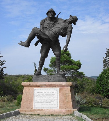
Mehmetcik Memorial
Open: 9am- 6pm daily
The Gallipoli Peninsula Historical National Park (Turkish:
Gelibolu Yarımadası Tarihi Milli Parkı), also known as the
Gallipoli Peninsula Historical Site, is a 33,000-hectare (330
km²) protected area at the southern end of the Gallipoli
(Gelibolu) Peninsula in Çanakkale Province, northwestern Turkey.
It lies on the European side of the Dardanelles Strait
(Hellespont), bordered by the Aegean Sea to the west and the
strait to the east. Established on 2 November 1973, the park
preserves the battlefields, trenches, cemeteries, memorials,
forts, and underwater wrecks of the 1915 Gallipoli Campaign
(also called the Dardanelles Campaign or Çanakkale Battles) from
World War I. It honors approximately 500,000 soldiers
(Turkish/Ottoman and Allied) who died, were wounded, or fell ill
there, while also protecting natural landscapes, beaches,
cliffs, and archaeological sites dating back to around 4000 BC.
The park was created through collaboration among the Turkish
government, the Foundation for Turkish Nature Conservation
(TTKD), the United States National Park Service, the Turkish
State Planning Organisation, and the Turkish National Parks
Department. It is included in the United Nations list of
National Parks and Protected Areas and is managed by the
Çanakkale Wars Gallipoli Historical Site Directorate (under the
Ministry of Agriculture and Forestry). Its purpose extends
beyond commemoration: it serves as a symbol of heroism, national
resilience, and peace, teaching lessons about the brutality of
war.
Ancient and Strategic History of the Peninsula (Thracian Chersonese)
The Gallipoli Peninsula has been strategically vital for millennia due
to its control of the Dardanelles, the narrow strait linking the Aegean
Sea to the Sea of Marmara and ultimately the Black Sea. In antiquity, it
was known as the Thracian Chersonese (Greek: Θρακικὴ Χερσόνησος). Greek
colonists (primarily Aeolian and Ionian) founded about a dozen cities
here in the 7th century BC, including Cardia, Pactya, Callipolis (modern
Gallipoli/Gelibolu), Sestos, Madytos, and Elaeus. The region was famous
for wheat production and as a key trade and military route between
Europe and Asia; Sestos was the main crossing point of the Hellespont.
Around 560 BC, the Athenian general Miltiades the Elder established a
colony, built a defensive wall across the isthmus at Bulair, and ruled
as tyrant over the Greek cities (a dynasty that lasted until his nephew
Miltiades the Younger). The peninsula changed hands frequently: it fell
to the Persians under Darius I in 493 BC during the Greco-Persian Wars,
returned to Athenian control afterward (joining the Delian League in 478
BC with additional settlers), was briefly held by Sparta after the
Peloponnesian War, and later passed to Philip II of Macedon in 338 BC.
After Alexander the Great’s death, it was contested among his
successors; Lysimachus made Lysimachia his capital, and it eventually
became part of the Roman province of Asia (133 BC) and later imperial
property under Augustus.
In the Middle Ages, it formed part of the
Byzantine (Eastern Roman) Empire. Attila the Hun invaded in 443 AD,
capturing key towns. The Ottomans seized Gallipoli in 1354 (following a
devastating earthquake), making it their first major European foothold
and a base for further expansion into the Balkans. The straits remained
a chokepoint: Xerxes I crossed them on pontoon bridges in 480 BC during
his invasion of Greece, and Alexander the Great crossed in the opposite
direction in 334 BC. Fortifications (castles like Kilitbahir, built
1452, and Seddülbahir) were built and rebuilt over centuries to control
shipping and defend against invasions.
The Gallipoli Campaign
(1915–1916): The Park’s Central Historical Significance
The park’s
modern identity is defined by the Gallipoli Campaign, a major Allied
operation in World War I aimed at forcing the Dardanelles, capturing
Constantinople (Istanbul), knocking the Ottoman Empire out of the war,
and opening a supply route to Russia. Proposed by Winston Churchill
(then First Lord of the Admiralty), the plan sought to relieve pressure
on the Western Front.
Naval Phase (February–March 1915): An
Anglo-French fleet bombarded Ottoman forts but failed disastrously on 18
March due to mines (notably laid by the minelayer Nusrat) and shore
artillery. Several battleships were sunk or damaged.
Land Campaign
(April 1915–January 1916): Amphibious landings began on 25 April 1915
(now ANZAC Day). British and French forces landed at Cape Helles
(southern tip); the Australian and New Zealand Army Corps (ANZAC) at
what became Anzac Cove (a mislanding north of the intended site); and a
French diversion at Kum Kale on the Asian shore. Ottoman defenses,
commanded by German General Liman von Sanders with key leadership from
Mustafa Kemal (later Atatürk), quickly contained the beachheads.
Fighting devolved into brutal trench warfare on rugged terrain of
cliffs, scrub, and beaches. Major battles included:
Repeated
attacks at Krithia (April–June).
The August Offensive: Australian
assault at Lone Pine, New Zealand attack at Chunuk Bair (briefly
captured but lost to Kemal’s counterattack), and a new landing at Suvla
Bay (which stalled).
Conditions were horrific: extreme heat,
thirst, flies, disease, and close-quarters combat. The campaign ended in
stalemate. Allied forces evacuated successfully by 9 January 1916 in one
of the war’s most orderly withdrawals. Casualties were enormous—roughly
250,000 on each side (Allied: ~213,000 total, including ~40,000–60,000
deaths; Ottoman/Turkish: similar figures, with ~200,000 martyrs/wounded
per Turkish accounts).
The campaign is iconic in Turkish history as a
heroic defense (“Çanakkale geçilmez” – “Çanakkale cannot be passed”) and
a catalyst for Turkish nationalism and Atatürk’s rise. For Australia and
New Zealand, it represents a “baptism of fire” and the birth of national
identity, embodied in the “Anzac spirit.”
Post-Campaign
Memorialization and the Creation of the National Park
After the war,
the Treaty of Lausanne (1923) and earlier armistices allowed for the
establishment of war cemeteries. The Commonwealth War Graves Commission
maintains 31 Allied cemeteries and monuments (with ~23,000 marked
graves), while Turkish authorities created over 50 martyrs’ cemeteries
and memorials. Traces of the fighting—trenches, fortifications, and
shipwrecks—remained remarkably preserved.
Proposals for a national
historical park circulated for decades. On 2 November 1973, the Turkish
government formally established the Gallipoli Peninsula Historical
National Park to honor the fallen and preserve the site as a “completely
Turkish Memorial” (in Atatürk’s words) and a lesson in peace. A 2000 law
strengthened its administration, granting ownership rights to the park
directorate. A 1994 forest fire (burning ~4,000 hectares) accelerated
restoration efforts, leading to the Long-Term Development Plan (approved
2007), infrastructure upgrades, cemetery restorations, and educational
facilities like the Kabatepe Simulation and Information Center.
Features and Modern Significance
Today, the park is an open-air
museum with:
Key Sites: Anzac Cove, Lone Pine Cemetery and Memorial
(Australian focus), Chunuk Bair (New Zealand), Cape Helles Memorial, the
57th Regiment Memorial (Turkish), Çanakkale Martyrs’ Memorial (with
names of 60,000 soldiers inscribed on slabs), and the Monument of Deep
Respect for Mehmetçik.
Natural and Cultural Elements: Indented
coastline, beaches, cliffs, Mediterranean vegetation, and archaeological
sites.
Infrastructure: Roads linking sites, information centers,
museums (e.g., Atatürk’s house at Bigalı), forts (Mecidiye, where
Corporal Seyyit’s legendary feat occurred), and underwater wrecks.
Visitor numbers grew from ~200,000 in 2002 to ~900,000 in 2011,
boosted by restorations. It is free to enter (museums have hours), open
year-round, and especially crowded on ANZAC Day (25 April). The park
emphasizes reconciliation—famously captured in Atatürk’s 1934 message to
Anzac mothers: “Your sons are now lying in our bosom and are in peace.
After having lost their lives on this land, they have become our sons as
well.”
Location and Boundaries
The park sits at the strategic junction of
Europe and Asia, bordered to the west and south by the Aegean Sea, to
the east by the Dardanelles Strait (Çanakkale Boğazı), and with a
terrestrial boundary to the north. The full Gallipoli Peninsula extends
about 60–80 km southwest into the Aegean Sea from the Thracian mainland,
narrowing to just a few kilometers wide in places (historically 4–18
km). The park covers the southern combat zones of the 1915 Gallipoli
Campaign, including key sites like Cape Helles, Anzac Cove, and Suvla
Bay. Its coordinates center around 40°10′13″N 26°22′04″E.
The
peninsula forms a natural land bridge controlling maritime access
between the Aegean, Sea of Marmara, and Black Sea via the Dardanelles.
Topography and Landforms
The terrain is rugged and deeply
incised, shaped by tectonic forces and erosion. Low-to-moderate hills
and ridges dominate, with steep slopes, ravines, gullies, spurs, and
plateaus. Elevations remain modest but tactically significant: the
highest point in the park area reaches about 308 m at Koca Çimen Tepe
(also called Kocaçimentepe), while other prominent ridges include
Conkbayırı and Alçıtepe.
Arıburnu Cliffs rise dramatically along
parts of the coast, creating sheer drops to the sea and narrow beaches
below. The landscape features NE-SW trending ridges and plateaus in the
south, with calcareous terraces stepping upward from the coast. Steep,
forested hills contrast with flatter agricultural plains near Suvla Bay.
This topography—steep slopes, limited flat ground, narrow beaches, and
interlocking ridges—profoundly influenced the 1915 campaign, restricting
advances and favoring defenders.
Geology and Geomorphology
The
underlying geology consists primarily of Neogene sedimentary rocks,
including limestones and other calcareous materials that form the cliffs
and terraces. Structural faults and the regional tectonic setting (near
the North Anatolian Fault system influence) have created the peninsula's
narrow, elongated form and incised drainage patterns. Gullies and
ravines exploit the structural grain, while coastal processes (wave
erosion, sea-level changes) have shaped beaches, coves, and cliffs. A
notable geomorphological feature is Tuz Gölü (Salt Lake or Tuzla Gölü)
near Suvla Bay, a former coastal lagoon now a shallow salt lake.
Climate
The park experiences a Mediterranean climate (Köppen Csa)
with transitional influences from the Black Sea region. Summers are hot
and dry (July–August average highs around 26–30°C or higher), while
winters are mild and wetter (coolest months around 6–13°C). Annual
precipitation averages moderate, with most rain falling in winter (peaks
of 80–120 mm/month). Sea breezes and strong winds are common due to the
peninsula's exposure between two bodies of water. Sea temperatures
average about 15–16°C annually.
Hydrology and Coastal Features
The area features highly indented coasts with sandy beaches, small bays,
coves, and rocky promontories. Famous examples include the short, narrow
beach at Anzac Cove (about 600 m long) and the Cape Helles landing
beaches. Waters are clear and blue, ideal for the park's scenic and
ecological value. Inland, seasonal streams flow through ravines; major
permanent rivers are absent. Tuz Gölü stands out as the primary inland
water body, a shallow saline lake surrounded by flatter terrain.
Flora and Vegetation
Vegetation reflects the Mediterranean character:
extensive pine forests (especially Aleppo pine, Pinus halepensis) cover
many steep hills and valleys (roughly 59–60% of the area is forested or
wooded). These mix with maquis scrub (dense Mediterranean shrubland),
olive groves, and other shrubs. Post-1994 wildfire regrowth (a major
fire burned ~4,000 ha near Arıburnu) includes shrubs and young trees.
Cypress trees appear in memorial plantings. The park supports high plant
biodiversity, with hundreds of species documented (over 470 in some
surveys), varying by slope, aspect, and soil. Some areas include
agricultural fields (wheat, sunflowers, orchards).
Fauna and
Biodiversity
The combination of forests, scrub, wetlands (salt lake),
and coastal habitats supports diverse wildlife. The park has strong
ecotourism potential for bird-watching, wildlife observation, and photo
safaris. Species include Mediterranean birds, small mammals, and
reptiles typical of the region; the area serves as a stopover or habitat
for migratory birds. The isolation at the intersection of Balkan,
Aegean, and Anatolian zones enhances its ecological value.
Overall Landscape Significance
The park blends dramatic natural
scenery—green forested hills descending to azure seas, dramatic cliffs,
quiet coves, and the unique salt lake—with profound historical layers.
Its rugged, compartmentalized terrain preserved battle remnants
(trenches, etc.) while fostering ecological recovery. Today, it
functions as a peaceful memorial landscape, protected for both its
natural beauty and cultural heritage.
Gallipoli Peninsula Historical National Park (Gelibolu Yarımadası
Tarihi Milli Parkı) in Turkey is one of the most poignant and
historically significant sites in the world. Established in 1973 and
covering about 33,000 hectares (330 km²) at the southern tip of the
Gallipoli Peninsula on the European side of the Dardanelles Strait, it
commemorates the 1915 Gallipoli Campaign (Çanakkale Savaşları) of World
War I. Roughly 500,000 soldiers from Ottoman Turkish, Australian, New
Zealand, British, French, and other forces lost their lives here in
brutal trench warfare. The park blends solemn war memorials, cemeteries,
preserved trenches, and battlefields with stunning natural
beauty—pine-forested hills, sandy beaches, cliffs overlooking the Aegean
and Dardanelles, and a salt lake (Tuz Gölü).
It’s a place of
reflection and remembrance for Turks, Australians, New Zealanders
(ANZACs), and others. The park is free to enter year-round with no
ticket required for the open-air sites, though some indoor museums have
small or seasonal fees and timed entry. It’s managed respectfully as a
national heritage area—no camping, picnicking, or damage to sites is
allowed.
Best Time to Visit
Spring (April–May) and autumn
(September–November) are ideal. Mild temperatures (around
15–25°C/59–77°F) make walking comfortable, with lower humidity and fewer
crowds outside of ANZAC Day. Wildflowers bloom in spring, and the
landscape is lush.
Summer (June–August) is hot and dry (up to
30–35°C/86–95°F+), good if you want beach time but tiring for full-day
exploration.
Winter (December–February) is cooler and wetter—less
popular but peaceful if you don’t mind rain.
ANZAC Day (25 April) is
the most meaningful (and crowded) time for Australians and New
Zealanders. It features dawn services, but requires advance
registration, security screening, and extra planning (more on this
below). Book 6–12 months ahead.
Allow at least one full day
(ideally 1–2 days) to cover the main sites without rushing. The area is
larger than it looks on maps.
How to Get There & Base Towns
The park lies about 300–350 km (186–217 miles) southwest of Istanbul.
From Istanbul: 4.5–6 hours by car/bus (via E6/D550 highways). Frequent
long-distance buses run to Eceabat or Çanakkale (check operators like
Metro Turizm or Kamil Koç). Domestic flights to Çanakkale Airport (CKZ)
take ~1 hour, then a short drive/ferry.
Ferries: Car/passenger
ferries cross the Dardanelles frequently from Çanakkale to Eceabat or
Kilitbahir (20–30 minutes; check Gestaş schedules and current fares, as
they change).
Best bases:
Eceabat (closest to ANZAC sites, quiet
harbor town).
Çanakkale (larger, more hotels/restaurants, lively
waterfront; short ferry to the peninsula).
Gelibolu town
(northern end) is too far for convenient day visits.
Pro tip: Rent a
car in Çanakkale or Istanbul for flexibility (international license
needed). Roads inside the park are paved but winding/hilly. Public
minibuses run limited routes (e.g., Eceabat–Kabatepe), but they’re not
ideal for touring all sites.
Touring Options
Guided tours are
highly recommended for first-timers. Knowledgeable local guides provide
historical context, stories of bravery and tragedy, and help navigate
the spread-out sites efficiently. Many day tours from Istanbul or
Çanakkale/Eceabat include transport, lunch, and entry to museums (prices
~€50–100+ per person; book via reputable operators). Multi-day tours can
combine with Troy (nearby on the Asian side).
Self-guided is doable
with a good map, guidebook (e.g., Holt’s Battlefield Guide), or free
audio apps (Australian Department of Veterans’ Affairs ANZAC Walk or
similar). There’s a one-way driving loop for the northern ANZAC sector.
Visitor centers/museums (for orientation):
Çanakkale Epic
Promotion Centre (Kabatepe) — Modern multimedia museum with exhibits,
films, and artifacts. Excellent starting point overlooking ANZAC Cove.
Hours typically 8/9 AM–5/5:30 PM (check seasonally; possible small fee
or timed tickets).
Key Sites & Suggested Itinerary (Northern
ANZAC Sector Focus)
Start at Kabatepe, then follow the loop northward
(sites are 5–15 minutes’ drive apart, with short walks):
ANZAC Cove —
The actual (miscalculated) landing beach. Moving and intimate.
Beach
Cemetery & Shrapnel Valley — Early graves and steep terrain.
Lone
Pine Cemetery & Memorial — Major Australian site; poignant lone pine
tree symbol.
The Nek, Quinn’s Post, Johnston’s Jolly — Preserved
trenches and viewpoints.
Chunuk Bair (Conkbayırı) — New Zealand
memorial with stunning views; site of fierce fighting.
Turkish 57th
Regiment Memorial — Honors Ottoman forces; very moving.
If time:
Drive south to Cape Helles (British/French memorials, Hellas Memorial)
and the massive Çanakkale Martyrs’ Memorial (Turkish national monument
with gardens and sea views).
The sites are well-signed, with
information panels. Expect respectful, reflective atmospheres—many
visitors leave poppies or notes.
Practical Visiting Tips
What
to bring/wear: Comfortable walking shoes (hilly, uneven paths, some
gravel). Layers for changing weather, hat, sunscreen, water bottle
(limited facilities inside park), light rain jacket, binoculars, and a
guidebook/app. Modest clothing is appreciated but not strictly enforced.
Etiquette & Rules: This is sacred ground—speak quietly, don’t climb on
memorials or remove anything, stay on paths. Alcohol is strictly banned
at all cemeteries and memorials. No drones or professional camera gear
without permits. Photography is fine respectfully.
Facilities:
Toilets and small cafes at main points (Kabatepe, some cemeteries).
Tours often include lunch. Bring snacks/cash.
Health & Safety: Good
general caution for Turkey (standard travel insurance advised). Terrain
can be slippery when wet; watch for traffic on narrow roads. The area is
peaceful but remote in parts.
Accessibility: Some sites have
steps/uneven ground; not fully wheelchair-friendly everywhere—check in
advance.
Special Notes for ANZAC Day (25 April)
If planning
for it: Register individually in advance via official channels (DVA or
Turkish authorities). Expect heavy security (airport-style screening,
banned items like large bags, liquids >100ml, drones), road closures,
shuttles, and very early starts. Accommodation books out a year ahead.
Accommodations, Food & Extras
Stay: Eceabat (e.g., boutique
guesthouses like Gallipoli Houses or Crowded House) or Çanakkale
(waterfront hotels). Book ahead in peak season.
Food: Fresh seafood,
Turkish mezes, and kebabs in base towns. Picnic options limited in park.
Combine with: Ancient Troy (short drive/ferry), Çanakkale’s museums, or
relaxing beaches.