Location: 19 km (12 mi) North of Denizli Map
Tel. (0258) 272 20 77
Open: 8am- 5pm daily
8am- 7pm daily (summer)
Hierapolis (Ancient Greek: Ἱεράπολις, lit. "Holy City") was
originally a Phrygian cult centre of the Anatolian mother goddess of
Cybele and later a Greek city. Its location was centred upon the
remarkable and copious hot springs in classical Phrygia in
southwestern Anatolia. Its extensive remains are adjacent to modern
Pamukkale in Turkey.
The hot springs have been used as a spa
since at least the 2nd century BC, with many patrons retiring or
dying there as evidenced by the large necropolis filled with tombs,
most famously that of Marcus Aurelius Ammianos, which bears a relief
depicting the earliest known example of a crank and rod mechanism,
and the Tomb of Philip the Apostle.
It was added as a UNESCO
World Heritage Site in 1988. In the archaeological site operates
since 1957 the "Italian Archaeological Mission of Hierapolis of
Frigia" (MAIER), currently directed by Grazia Semeraro, Professor of
Classical Archaeology of the University of Salento.
During excavations carried out in 2016, evidence was found that
settlement in the region began in the Iron Age. In the area where the
city is located, there was a religious center dedicated to Cybele, the
mother goddess of Anatolia, during the Phrygian period. This temple,
which was originally used by the indigenous communities living in the
Lykos (Çürüksu) valley, would later form the center of Hierapolis. When
Greek colonists arrived and built the city on the pre-existing
settlement pattern, the ancient cult of Cybele was gradually assimilated
into Greek mythology.
Long before the time of Greek colonization,
the region was seen as a gateway to the underworld and also a place to
communicate with the underground gods, due to the poisonous gases
emanating from a hot spring in a cave located here. With the
assimilation process into Greek culture, the temple became associated
with Hades (Pluto) and Persephone instead of Cybele, and the temple was
named Plutonium.
Although information about the founding of the
city is limited; During the Kingdom of Pergamon II. It is known that it
was founded by Eumenes in the early 2nd century BC and was named
Hierapolis after the Amazon queen Hiera, the wife of Telephos, the
legendary founder of Pergamum. Hierapolis maintained its original
texture by adhering to the Hellenistic urbanization principles until the
great earthquake in 60 AD during the reign of Roman Emperor Nero.
Located on the earthquake zone, the city was greatly damaged by the
earthquake of the Nero period and was completely renovated. After these
earthquakes, the city lost all its Hellenistic character and took on the
appearance of a typical Roman city. After the Roman period, Hierapolis
became a very important center during the Byzantine period. This
importance stems from the fact that it has been the center of
Christianity (metropolis) since the 4th century AD, and that Philip, one
of Jesus' apostles, was killed here in 80 AD.
Hierapolis, which
came under Byzantine rule in 395 AD, became the center of the Diocese.
Hierapolis remained within the borders of the Anatolian Seljuks towards
the end of the 12th century. In the ancient city of Hierapolis;
Necropolis, Domitian road and gate, Oktokonus temple placed in a square
area, theatre, Frontinus street and gate, Agora, Northern Byzantine
Gate, Southern Byzantine Gate, Gymnasium, Triton Fountain Building,
Apollon Sanctuary, water channels and nymphaeums, Wall, Filipus Martynon
and its bridge, Direkli Church, Necropolis Area, Cathedral and Roman
Bath ruins.
Pamukkale has attracted tourists throughout history
thanks to its underground waters (travertines), which are also used for
therapeutic purposes.
The bath was built outside the city for
travelers to wash themselves and enter the city.
Since the
theater capacity is 9,500 people, the city population is estimated to be
between 95,000-100,000.
It is understood from the design of the
theater that gladiator fights were held here. There is a height
difference of approximately one meter between the hollow section under
the stage and the rows of seats to protect the audience from wild
animals. In theaters where there are no gladiator fights, this
difference does not exist, and the rows start from the stage level.
The Medusa figure carved at the entrance gate of the city was made
to protect from the goddess Medusa. It is thought that this belief was
transferred to Turkish culture as an evil eye bead. The city was
included in the UNESCO World Heritage List as both natural and cultural
heritage on 09.12.1988.
It is a large building of Greek Theater type, leaning on a hillside,
with a height of 300 feet (91 m) and its entire façade can be preserved.
To its construction; It was started in 62 during the Flavian period,
after a major earthquake in 60. It was under construction during the
reign of Hadrian (117-137). The structure was completed in 206 during
the Severus period.
There are 50 rows of seating in Cavea. These
seating rows are divided into 7 sections by 8 stairs. Diozoma, which
passes through the middle of the Cavea, is entered through a vaulted
passage (vomitorium) on both sides. There are 5 doors and six niches on
the 6-foot (3.66 m) high stage front wall surrounding the royal lodge
and orchestra located in the middle of the cavea, and there are 10
columns in front of them. The marble columns are decorated with oyster
shell-shaped motifs. Of the 3 columns lined up on top of each other that
decorate the back wall behind the stage, the lower ones rise on
octagonal bases and are unfluted.
As can be seen from their
styles, the reliefs were made by different masters in different periods.
It is possible to see the effects of Hellenistic period sculpture arts
in crowded, active and lively figures, especially in scenes where
mythological subjects are depicted. Some influence of the Pergamon
school of art (Zeus Horses Reliefs) can be seen in these figures. The
theater is very similar to the theaters of Perge, Side and Nyssa in
terms of the decoration of the stage building with relief friezes.
Necropolises, which represent cemetery areas, gained a special
importance after Hierapolis was named the 'Holy City'. Research
conducted in these necropolises reveals all the religious beliefs of the
period. These necropolises, which can be easily divided into wealthy or
public graves according to the magnificence of their tomb structures,
lie in the north and south direction of the city's main street. Their
number is more than 2 thousand.
There are necropolis areas outside the city walls and in all
directions outside the plain. These are mostly located on both sides of
the northern road leading to Tripolis-Sardes and the southern road
leading to Laodicea-Clossae. Limestone and marble were used in the
graves. The use of marble is mostly seen in sarcophagus types.
Northern Necropolis: The fact that the monuments in the necropolis are
well preserved and are located in a wide area with many travertine
sarcophagi creates an impressive appearance. (There are more than two
thousand of them, and the inscription in most of them bears the Greek
word Soros Sufiksi.)
The architecture of Hierapolis tomb
monuments is very diverse and shows different applications. The oldest
tombs are Tumulus tombs dating back to the Hellenistic Period (II - I
century BC). In these graves, the burial chamber is surrounded by a
cylindrical drum made of properly cut stones and is covered with
cone-shaped soil. The burial chamber is reached through the corridor
called dramamos. The tumuli are located along the road and on the slope
leading to the east.
These tombs mostly belong to elite families,
while poor families are simple tombs carved into rocks. Located in the
northern part of the city, I., mostly II. and III. Other tomb monuments,
dating back to the 16th century, usually have gardens surrounded by
walls and decorated with trees (mostly cypresses) and flowers. Grave
monuments made entirely of travertine show different types: They range
from a simple sarcophagus to more advanced forms, sometimes containing
dead beds, with a triangular pediment or on a pedestal, carrying one or
more sarcophagi, and sometimes reflecting house models. The inscription
on the pedestal carrying the sarcophagi includes the Greek word bomos
(stand, altar): It carries a symbolic meaning that glorifies the memory
of the dead in connection with the body of the deceased standing high.
These monuments have the same function as heroon. (Funeral monuments
built to celebrate the deification of heroes or important people in
history after their death.)
Southern Necropolis: Impressive
traces of the earthquake can be seen on the right. The wide travertine
plain has been completely turned upside down. Rectangular pit graves and
traces of a quarry belonging to a simple and perhaps older necropolis
attract attention. During the excavations, Denizli Museum experts found
a tomb structure with bomos with long inscriptions. Nearby, there is a
tumulus tomb dating back to the Young Hellenistic Period, and marble
stelae with inscriptions were found next to it. Excavations continue in
the north of the area, and marble sarcophagi with figures were found in
the tomb structures on the slope where the Byzantine walls are located.
These sarcophagi stand on a stone base. The roof, which is raised with
adobe bricks, is covered with tiles. This type constitutes an
innovation. The interior of the tomb structure is decorated with
multicolored frescoes. As you move south towards the Gate, which may
belong to Frontinus, you encounter other tomb structures belonging to
the necropolis on the road leading to Laodicea and Colossea.
The
tomb of Tiberius Cladius Talamos, mentioned in the long inscription,
attracts attention. Its façade reflects the architecture of the house,
with half-columned Doric pilasters, stone lattice windows, an
architrave, an inscribed frieze and a tooth-cut Ionic entablature, as in
Blaundos. It reminds us of Frontinus Street only in terms of
architectural arrangement. In the buildings on Frontinus Street, the
Doric order naturally shows itself in the capitals as well as in the
triglyph-metope frieze entablature.
The Ancient Pool is one of the most important symbols of Pamukkale.
It is considered one of the few pools in the world, especially with its
water that is beneficial to health. This pool, where thousands of people
swim every year, is also good for many diseases. Especially during the
Roman Empire Period, Hierapolis and its surroundings were a complete
health center. In those years, thousands of people came to the more than
15 baths built in and around the city to regain their health. The
ancient pool that forms today is AD VII. It is the earthquake that
occurred in the century. The portico, built in the Ionic order (1st
century AD) belonging to the civil agora located next to the columned
street, collapsed into the pool that formed within the fracture that
occurred as a result of this earthquake.
In addition to having a
relaxing effect due to the temperature of the water, the Antique Pool is
also effective in curing many diseases. According to research on this
subject, the water of the Ancient Pool is very good for heart disease,
arteriosclerosis, blood pressure, rheumatism, skin, eye, rickets,
paralysis, nerve and vascular diseases, and when drunk, it is very good
for spasmodic stomachs. This clearly reveals the reason why health
centers have been constantly established around the Ancient Pool since
the Roman Period.
The water temperature in the thermal pool is 36 °C - 57 °C, PH value
is 5.8, and radon value is 1480 piccocuri/liter. Thermal spring waters
have bicarbonate, sulfate, calcium, carbon dioxide, partially iron and
radioactive composition. At the same time, the waters here are suitable
for bathing and drinking cures and have a dissolved mineral value of
2430 MG / liter.
The Temple of Apollo, which has managed to
survive by preserving all its magnificence from centuries ago to the
present day, was built on Plutonion, known as an old and religious cave.
Among the ruins remaining from the temple, the marble stairs and the
walls with inscriptions describing the prophecy of Apollo are among the
most important works worth seeing. These lands, which have hosted many
civilizations, have also contributed to the development of religious
tourism.
The current Temple was built on Plutonion, known as the ancient and
religious cave. In this place, which is the oldest religious center of
the local people, Apollo met with Kybele, the mother goddess of the
region. Ancient sources report that the priest of the Mother Goddess
Kybele descended into this cave and was not affected by the poisonous
gas. The ruins of the superstructure in the Temple of Apollo date back
to AD III. Although it does not date back to the 11th century, the
foundations date back to the Late Hellenistic Period.
The
70-meter-long Temple, known from its marble entrance steps, is located
within the sacred area surrounded by the temenos wall. The temenos wall
leans on the portico, some of which have been excavated, in the south,
west and north. The Doric fluted half-columns of the marble portico
carry column capitals decorated with astragals and strings of pearls,
and echinus with strings of eggs.
The temple dates back to a
later period, but the two exquisite ion-one Corinthian capitals and some
architectural pieces in the museum date back to the 1st century AD and
indicate the existence of a temple dating back to earlier times. Apart
from the marble staircase that has survived from the Temple of Apollo,
there is a podium covered with marble slabs and molded cornices. Its
facade is decorated with two antes and two columns between them. Its
dating can be done thanks to the inscribed blocks used on the antes and
headings, on the cella wall and on the floor. An inscription belonging
to the prophecy of Apollo is read on one of them. According to the
architectural decorations, the temple dates back to AD III. It dates
back to the century.
On the staircase behind the temple, an area
filled with pieces taken from the Temple of Apollo, column bodies,
architrave pieces, capitals and pedestals can be seen. In this
structure, BC IV. A fine female statue with pleated clothes, which
renewed the sculpture schemes of the 19th century, was found. As can be
understood from the inscription; Apphia, daughter of Zeuxis, was
dedicated to the imperial gods and Demos (personification of the people
of Hierapolis).
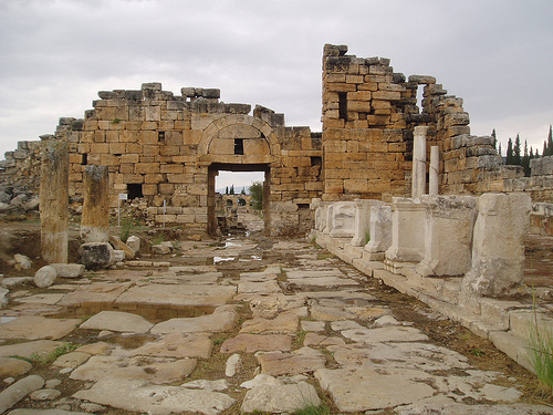
The 1 km long Street, one end of which extends to
the Domitian Gate, named after the Emperor Domitian, in the north, and
the other end to the South Roman Gate in the south, are among the most
important historical monuments worth seeing. The street, with columned
porticoes and public buildings on both sides, divides the city into two
from one end to the other. In addition, the gates at the street
entrances and exits are the best examples of a huge civilization that
still carries its history on its shoulders.
The city's most important and wide main street, which is
approximately 1 km long, divides the city into two from one end to the
other. There are porticoes with columns and important public buildings
on both sides of this street, which extends in the north-south
direction. There are monumental gates at both ends. The gates look like
triumphal arches, are arched and have towers on their sides. Frontinus
Gate: It forms the monumental entrance gate of the city in the Roman
Period. Located at the beginning of the 14-meter-wide main street, the
gate is located at the opposite end of the South Gate and the main road
that passes the settlement and leads to Laodicea and Collosai. The
three-arched entrance of the gate is built of smooth travertine blocks
and is decorated with a simple cornice. It also leans on round towers
that remind us of the gate tradition of the Hellenistic Period.
There is an inscription written in Latin and Greek, dedicated to Emperor
Domitian, on the frieze of the well-preserved gate in the north, which
has three eyes and round towers on both sides. Because of this
inscription, it is called Domitian's Gate or Roman Gate. The door was
opened by Julius Sextus Frontinüs, Proconsul of Asia, I.S. It is known
that it was built in 82-83. For this reason, the gate is also called the
Frontinus Gate. Where the road leading south from this gate intersects
with the city wall, there is the Northern Byzantine Gate, dating back to
the 5th century AD.
South Roman Gate: The gate opens to the hill
descending towards the Lykos River, is located right opposite the large
Honaz Mountain, and has a delightful view of all shades of blue,
especially at sunset. The door was made of travertine blocks and reused
materials, including marble. It is leaning on two rectangular planned
towers.
Northern Byzantine Gate: The Northern Gate, which was
included in the city wall system of the city of Hierapolis built during
the Theodosius period (end of the 4th century AD), symmetrically to the
Southern Gate, constitutes the monumental entrance of the city during
the Byzantine Period. The gate, built with spolia material taken from
the ruins of the Agora, was supported by two square-plan towers. On both
sides of the entrance, four consoles decorated with lion, panther and
gorgo heads standing apotropaically to protect the city from bad
influences have survived to the present day.
South Byzantine
Gate: It was built in the 5th century AD. It was made with travertine
blocks and reused materials including marble. Like the gate in the
north, it leans on two quadrangular towers and is shaped with a relief
arch on a single-piece architrave.
Hierapolis, which has a religious importance, also attached great importance to cleanliness in ancient times. They built baths at the entrances and exits of the city so that travelers would be clean when they entered the city. There are 3 baths in Hierapolis. Among these baths, the Bath Church has been well preserved until today. Byzantine Bath VII. It was destroyed in the great earthquake that occurred in the century. The Great Bath is today's Archaeological Museum.
This very old building dates back to the middle of the Imperial Age. Large arches on the side walls of this building, built of travertine rectangular blocks, can be seen. It has an architecture comparable to the vaulted Great Bath structure in the center of the city. Bath structure VI. It was reorganized as a church in the 1st half of the century, when Hierapolis became the capital of Phrygia Pacatiana. In this building, which was converted into a church, they used the wall of a place located to the north of the entrance to surround a four-column pot. The entrance of the church, which is formed with two large arches, leans against another small door with an arch, as in the Byzantine Gate. In the large space, which is preserved in good condition, there are 6 niches formed by arches. Walls carrying these arches were added and vaulted passages were created with passages opening to the walls.
It dates back to a period immediately after the construction of the Sur system. The structure was built on the ruins of the southern stoa of the Agora. The bath building is located right after the gate and nymphaeum at the entrance of the city, and this building, built for public use, is separated from the walls by a narrow road. An apsidal space is interpreted as a calidarium with a plaster pool and hypocaust system. The roof of the place unearthed during the excavations should have been covered with a brick dome, according to the fragments we found in ruins. With the completion of the excavation of this building, important information will be obtained about the typology of the public baths of the Imperial Period in the transition to the bath structures of the Islamic world in the Middle Ages. According to archaeological data, the structure was built in the VII century, which destroyed the entire city. It was abandoned after the earthquake in the 19th century.
The Great Bath structure, where the Hierapolis Archaeological Museum
is located today, is located in the southwest of the city, in an area
opening to travertine channels. After the great earthquake in 60 AD
during the reign of Nero, in order to benefit from an important water
source during the construction activities in the city, II. It was built
in the century. The water from the source still passes over the ruins of
this bath before flowing into the valley.
The bath is a stone
work of local workers who were skilled in working with travertine, which
is abundant in the region. Due to the limestone-forming power of flowing
water, the structure, whose original base is buried under 4 meters of
limestone today, has been preserved in two places and repairs have been
made in the others. The spaces used as museums today were heated by a
hypocaust system in ancient times. Excavations and restoration works are
carried out by the Turkish Ministry of Culture, General Directorate of
Monuments and Museums to find the original floors of the places. In the
Middle Ages, Roman Period spaces were changed, divided by walls and
spread all the way to the road.
From the 10th century AD to the
12th century. In the period up to the 11th century, the settlement and
its influence exceeded that of ancient times. The glazed doors, many of
which were imported, found during excavations from the Byzantine and
Seljuk periods, draw attention to the wealth of those who used the bath
in this period. At the end of the 18th century, the columns mentioned by
Choisy, one of which is covered with a ribbed barrel vault roof, can be
observed. New excavations in Hall T have brought to light an original
space with an apse and three large windows bordered by a cornice on the
west side.
Typical Roman architectural solutions were generally
used on the side facades of the spaces, with quadrangular or round
planned spaces enlivening the interior, and the building was decorated
with marble statues showing the power of Rome. The largest space, D,
measures 20X32 meters and on its long side there are three exedrae, one
of which is quadrangular and the other is semicircular in plan. The
exedrae are covered with decorated arches and decorated stuccos. In the
decorations, sea shell motifs in the middle and volute, leaf and flower
motifs on the edges can be recognized. The walls must have been covered
with multicolored marble slabs, as can be seen from the metal clamp
holes seen on their surfaces. At the entrance, there is a door on two
legs and a space with stairs leading to the roof of the building. The
large area to the east of this section is reserved for the palestra. The
large rectangular spaces opening onto the palestra have columned facades
made of local, white and pink stained bresten.