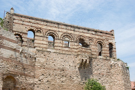
Location: Hisaraltı Cd 19-25, Sümbül Efendi Mh.
The Constantinople City Walls, also known as the Theodosian Walls, are one of the most impressive and enduring defensive systems of the ancient and medieval world. Located in Istanbul, Türkiye, these walls protected the city of Constantinople (modern Istanbul) for over a millennium, from the 5th century until the Ottoman conquest in 1453. They are a testament to Byzantine engineering, strategic urban planning, and the city's role as a crossroads of civilizations.
Origins and Construction (4th–5th Century CE)
Constantine’s Early
Walls: When Emperor Constantine I founded Constantinople in 330 CE as
the new capital of the Roman Empire, he built a modest set of walls to
protect the city. These walls, enclosing a smaller area, quickly became
inadequate as the city grew.
Theodosian Walls: The current, more
extensive walls were commissioned under Emperor Theodosius II in the
early 5th century, with construction largely completed between 408 and
413 CE under the supervision of the prefect Anthemius. They were named
after Theodosius II, though much of the work was carried out during his
minority.
Earthquake and Expansion: A major earthquake in 447 CE
damaged parts of the newly built walls. They were swiftly repaired and
strengthened under the direction of the prefect Constantine, just in
time to repel an attack by Attila the Hun in 447. Additional
fortifications, including an outer wall and moat, were added during this
reconstruction.
Byzantine Period (5th–15th Century)
The
Theodosian Walls were the backbone of Constantinople’s defense,
protecting the city from numerous sieges by Persians, Avars, Arabs,
Bulgars, Rus’, and Crusaders.
The walls were repeatedly repaired and
reinforced, especially after earthquakes, which were frequent in the
region. Byzantine emperors, such as Justinian I and later rulers,
invested heavily in their maintenance.
The walls successfully
repelled attackers for centuries, including the Arab sieges of 674–678
and 717–718, and the Avar-Slavic siege of 626, earning Constantinople a
reputation as an impregnable fortress.
Fall of Constantinople
(1453)
The walls met their ultimate test during the Ottoman siege of
Constantinople in 1453, led by Sultan Mehmed II (Mehmed the Conqueror).
The Ottoman forces, equipped with massive cannons designed by the
engineer Orban, bombarded the walls relentlessly.
Despite heroic
Byzantine resistance under Emperor Constantine XI, the walls were
breached on May 29, 1453, at the Gate of St. Romanus (Topkapı Gate),
marking the fall of Constantinople and the end of the Byzantine Empire.
The Ottoman victory was due to a combination of superior artillery,
overwhelming numbers, and strategic innovations, such as dragging ships
overland to bypass the Golden Horn’s defenses.
Ottoman and Modern
Periods
After 1453, the Ottomans repaired and maintained parts of the
walls, though the city’s expansion and new defensive priorities reduced
their strategic importance.
By the 19th century, the walls were
largely neglected as Istanbul modernized. Some sections were demolished
or repurposed for urban development.
In the 20th century, restoration
efforts began, particularly in the 1980s, when the walls were included
in Istanbul’s UNESCO World Heritage Site designation (1985, as part of
the Historic Areas of Istanbul). Today, they remain a major historical
attraction, though parts are in disrepair.
The Constantinople City Walls are a masterpiece of military
architecture, combining Roman engineering traditions with Byzantine
innovations. They stretch approximately 22 kilometers (14 miles) around
the historic peninsula of Istanbul, enclosing the city on its landward
and seaward sides. The most famous and well-preserved section is the
Theodosian Walls, which protect the landward side, facing west.
Theodosian Walls (Land Walls)
The Theodosian Walls, running 6.5
kilometers (4 miles) from the Golden Horn to the Sea of Marmara, are the
most iconic part of the system. They consist of a multi-layered
defensive structure designed to withstand prolonged sieges.
Moat:
A wide, artificial moat, up to 20 meters (66 feet) wide and 10 meters
(33 feet) deep, formed the first line of defense. It was often filled
with water from nearby cisterns or rainwater.
The moat was crossed by
drawbridges at key gates, making direct assaults difficult.
Outer
Wall (Low Wall):
Beyond the moat, a low outer wall, about 2 meters
(6.5 feet) high, served as a secondary barrier. It included crenelated
parapets for archers and small towers for additional defense.
A
terrace (peribolos) between the outer and main walls allowed defenders
to maneuver and counterattack.
Main Wall (Inner Wall):
The
main wall, the most formidable component, stood 8–12 meters (26–39 feet)
high and 5 meters (16 feet) thick. It was constructed with alternating
layers of limestone blocks and red brick, a hallmark of Byzantine
architecture that provided both strength and flexibility during
earthquakes.
The wall was punctuated by 96 towers, spaced roughly 55
meters (180 feet) apart. These towers, typically square or octagonal,
rose 15–20 meters (49–66 feet) high and housed artillery, archers, and
storage for supplies.
Each tower was independent, with no internal
connection to adjacent sections, preventing attackers from gaining
control of the entire wall if one tower was breached.
Gates:
The walls featured several gates, alternating between military and
public access points:
Golden Gate (Yedikule): The ceremonial entrance
near the Sea of Marmara, used for imperial processions and triumphal
entries. It was a triple-arched structure adorned with marble and
statues, later incorporated into the Yedikule Fortress by the Ottomans.
Gate of St. Romanus (Topkapı Gate): A key military gate, heavily damaged
during the 1453 siege and the site of the final Ottoman breach.
Charisius Gate (Edirnekapı): The highest point of the walls, used by
Mehmed II to enter the city in 1453.
Gate of Spring (Silivrikapı) and
Gate of Rhegium (Meolanitkapı): Other notable public gates.
Military
gates were smaller and more fortified, designed for defensive sorties.
Inscriptions and Decorations:
Many towers bear Greek inscriptions
commemorating repairs by emperors like Theodosius II, Justinian I, and
Leo V. These provide valuable historical records of maintenance efforts.
The Golden Gate featured reliefs and statues, including a bronze
quadriga (four-horse chariot), symbolizing imperial grandeur.
Sea
Walls
The sea walls extended along the Golden Horn (north) and the
Sea of Marmara (south), totaling about 15 kilometers (9 miles).
These
walls were less formidable than the land walls, as the city’s natural
geography—steep shores and strong currents—provided additional
protection.
The Golden Horn walls were linked to a massive chain that
could be raised to block enemy ships, a critical defense during sieges.
The sea walls included smaller towers and gates, such as the Eugenius
Gate, and were frequently repaired due to erosion and wave damage.
Yedikule Fortress
After 1453, the Ottomans built the Yedikule
(Seven Towers) Fortress, incorporating the Golden Gate and adding new
towers. It served as a treasury, prison, and execution site, notably for
high-profile prisoners like Ottoman princes and foreign ambassadors.
The city walls of Constantinople were planned as a complete shield
against both land armies and fleets. Builders combined the peninsula’s
natural position - water on three sides - with one of the most
sophisticated man-made fortification systems of the ancient and medieval
world.
Landward defense
The famous Theodosian Walls, begun
under Emperor Theodosius II and supervised by Praetorian Prefect
Anthemius, were largely finished between about 413 and 439 CE. They
stretched roughly 5.7-6.5 km from the Sea of Marmara to the Golden Horn
and added about 5 square kilometers to the enclosed city. After a
devastating earthquake in 447 flattened dozens of towers, an outer wall
and a broad moat were added in only two months while the Huns threatened
from the east.
The finished system used defense in depth. Attackers
first met a moat 15-20 meters wide and 5-10 meters deep that could be
flooded from pipes and held by stone dams; a low wall about 1.5-2 meters
high ran along its inner edge. Next came an outer wall roughly 2 meters
thick and 8-9 meters high, backed by a terrace (the peribolos) that
served as a killing field. The final barrier was the massive inner wall,
4.5-6 meters thick and about 12 meters high, faced with cut limestone
and banded with brick for earthquake resistance. Ninety-six towers rose
15-20 meters on the inner wall and another 96 on the outer wall (about
192 in total), spaced so that fire from one line did not block the
other. Square and octagonal towers held artillery and later Greek fire.
Ten principal gates, including the monumental Golden Gate, controlled
peacetime traffic while remaining easily sealed in war.
Sea
defense
Single-line sea walls ran along the Marmara shore (about 8.5
km) and the Golden Horn (about 5.6 km), studded with more than 200
towers in all. The Golden Horn itself was closed by a massive iron chain
some 750 meters long, first deployed under Emperor Leo III during the
Arab siege of 717-718. The chain stretched from the Tower of Eugenius on
the city side to a tower on the Galata shore and was supported on floats
or barges. Combined with the Byzantine navy and the incendiary weapon
known as Greek fire, the chain made a successful amphibious landing
extremely difficult.
Psychological impact
The walls were not
only functional; they were a statement. Their height, length, and
layered towers presented an almost theatrical barrier. For centuries
they advertised Constantinople as an impregnable imperial capital,
discouraging many would-be attackers before a siege even began.
Siege resilience
Inside the circuit lay large cisterns (including the
Basilica Cistern), granaries, and patches of cultivated land, so the
city could endure long blockades. The northwestern Blachernae quarter,
which contained an imperial palace and important churches, received
extra walls in later centuries - under Heraclius, Leo V, and especially
Manuel I Komnenos - because it sat slightly outside the original
Theodosian line.
Record of success
These combined defenses
held against Avars and Persians (626), two major Arab sieges (674-678
and 717-718), Bulgars, Rus, and many smaller attempts. The Fourth
Crusade entered in 1204 more through political collapse and a naval
assault on the Golden Horn than through a clean breach of the land
walls. Only in 1453 did the system finally fail, when Sultan Mehmed II’s
giant gunpowder bombards opened gaps that medieval siege engines could
never have made.
Symbol of Byzantine Power
The Theodosian Walls were more than
stone. They were the physical proof that Constantinople was the New
Rome, the capital of an empire that claimed to carry the old Roman world
forward under a Christian banner. Built in the early fifth century under
Theodosius II and his prefect Anthemius, the land walls stretched about
6.5 km from the Sea of Marmara to the Golden Horn. An inner wall 12 m
high and 4.5-6 m thick, 96 towers, an outer wall, and a wide moat
created a defense in depth that no earlier city wall could match.
For
more than eight centuries those ramparts guarded the empire’s political
heart, its churches, palaces, libraries, and relics. Hagia Sophia,
rebuilt by Justinian after the Nika Riot of 532, stood inside that
circuit as the city’s greatest sacred monument. As long as the walls
held, the emperor, the patriarch, and the city’s treasures remained out
of reach. When the walls finally failed in 1453 under Ottoman cannon
fire, the last Byzantine emperor fell with them.
Engineering
Legacy
The Theodosian system set a standard that later medieval
builders studied even when they could not copy it at the same scale. The
combination of a high inner wall, a lower outer wall, a moat, and towers
that could fight as independent strongpoints was a model of layered
defense. Alternating bands of brick and limestone made the masonry both
strong and distinctive.
Western Europe did not produce comparable
urban fortifications until the twelfth century. Crusader castles such as
Krak des Chevaliers used concentric walls and multiple lines of defense
that echo the Constantinopolitan idea, even if they were built on a
smaller footprint. In the Islamic world, later city defenses and
citadels absorbed the same lesson: height plus depth, not a single
curtain, is what stops an army. The walls themselves lasted through
earthquakes, Avar and Persian attacks in 626, two major Arab sieges
(674-678 and 717-718), Bulgar assaults, and the Latin sack of 1204,
which entered by a neglected sea-wall gate rather than by breaking the
land front.
Historical Record
The masonry is a written
archive. Latin and Greek inscriptions name emperors, prefects, and
repair campaigns. After the earthquake of 447, with Attila approaching,
the walls were rebuilt in sixty days; the work is recorded at the
Rhegium Gate (Mevlevihane Kapısı) in both languages. Later texts mark
repairs under Justin II and Sophia, Leo III and Constantine V after the
quake of 740, Theophilos and Michael III in the ninth century, Basil II
and Constantine VIII on the Marble Tower, and John VIII Palaiologos in
the years before 1453.
Graffiti, reused blocks, blocked gates, and
Ottoman patches sit beside Byzantine brick stamps and monograms.
Together they trace sieges, earthquakes, tax levies for reconstruction,
and the slow shift from a Christian imperial capital to an Ottoman one.
Walking the surviving stretches today is walking a timeline cut into
stone.
Cultural Crossroads
The walls stood on the landward
side of a city that looked both ways. They protected a capital that
spoke Greek, claimed Roman law, worshipped in churches filled with
mosaics, and traded with every shore of the Mediterranean and Black Sea.
After 1453 the same circuit enclosed a city whose skyline gained
minarets while the old land walls remained in use and in repair.
Large stretches of the Theodosian Land Walls still stand, but their
state is uneven. Near the Golden Gate and Edirnekapı the inner wall,
towers, and some outer works are relatively complete or have been
stabilized. Other lengths are broken, overgrown, or reduced to cores of
brick and limestone after earthquakes, traffic vibration, and decades of
neglect. Nineteenth-century rail cuts, later road widenings, and housing
pressed against the curtain walls removed or buried parts of the outer
wall and moat. The 1999 Marmara earthquake and later aftershocks opened
fresh cracks in towers that already lacked intermediate floors.
The
land circuit runs about 5.7 km from the Marmara shore at Yedikule to the
Blachernae sector near Ayvansaray, with the later Blachernae walls
adding further length toward the Golden Horn. Together the land defenses
measure roughly 6.5–6.7 km. The sea walls along Kennedy Caddesi are more
fragmentary and harder to walk continuously.
Restoration Efforts
Serious municipal campaigns began after the walls entered the UNESCO
listing in 1985. Work in 1986–89 at Belgradkapı, Silivrikapı, and
Mevlanakapı rebuilt gates and some curtain walls to a fifth-century
“complete” look. Conservators later criticized those campaigns for weak
documentation, new rubble cores, and towers that looked newly built
rather than repaired. UNESCO warned Turkish authorities in 2004 about
authenticity problems.
From the early 1990s the approach shifted
toward consolidation: stabilize what survives, limit reconstruction, and
keep later Ottoman repairs visible. Istanbul Technical University teams
and specialists such as Zeynep Ahunbay argued for minimum intervention.
After 2020, İBB Miras and Fatih Municipality opened visitor centers at
Mevlanakapı, Silivrikapı, and Belgradkapı, cleared parks along the inner
face (Karasurları Millet Bahçesi), and treated Yedikule as a live
restoration site rather than a finished museum. Even so, collapses still
occur on unrestored stretches, and funding and political attention
remain uneven compared with Ottoman monuments.
UNESCO Status
The walls form one of the four components of the Historic Areas of
Istanbul, inscribed in 1985. ICOMOS highlighted the 6,650-meter
Theodosian system, with its second line of defense added in 447, as a
reference work of military architecture for Europe and the Near East.
The site has at times been discussed in “World Heritage in Danger” terms
because of traffic, pollution, informal building, and earlier
over-restoration. Protection exists on paper. Pressure from the modern
city continues on the ground.
Tourism
The walls are among
Istanbul’s least crowded major monuments. Restored gates and visitor
centers let you walk battlements, look into the space between inner and
outer walls, and see the old moat used today as gardens. Views take in
the Marmara, the historic peninsula, and, from the Edirnekapı ridge, the
dome of the Chora Church (Kariye Mosque). Yedikule combines the marble
Golden Gate with Ottoman prison towers. The 1453 breach zone near
Topkapı is not marked by a grand monument; it is a patched, irregular
stretch of masonry.
Theodosian Walls of Constantinople
The Theodosian land walls still
run across the western edge of Istanbul’s historic peninsula, from the
Golden Horn near Ayvansaray and the old Blachernae quarter down to the
Sea of Marmara at Yedikule. Built in the early 5th century under
Theodosius II (the work was directed by Praetorian Prefect Anthemius),
they formed a triple line of defense: a wide moat, a lower outer wall
with dozens of towers, and a massive inner wall about 12 m high and 5 m
thick, strengthened by 96 main towers. Together with later Blachernae
additions, the land circuit is roughly 6.5–7 km long. For more than a
thousand years these walls held off Persians, Avars, Arabs, Bulgars, and
Rus. They finally failed on 29 May 1453, when Ottoman cannon fire opened
a breach near the Gate of St. Romanus (today’s Topkapı area). The sea
walls along Kennedy Avenue are harder to walk but remain visible from
the waterfront.
Access
Most of the land walls are open-air and
free. You can walk beside them, and in places climb restored stretches,
especially around Edirnekapı. Yedikule Fortress (the Ottoman “Fortress
of the Seven Towers” wrapped around the Byzantine Golden Gate) is a
ticketed site. Hours and prices change; recent reports list opening
roughly 09:00–16:30, closed one weekday, with foreign admission in the
hundreds of Turkish lira. Confirm locally before you go. Small free
visitor points have opened at some gates (Belgradkapı, Mevlanakapı,
Silivrikapı) with boards and modest facilities.
Highlights
Golden Gate and Yedikule Fortress. The Golden Gate was the marble
triumphal entrance used by victorious emperors. After 1453 Mehmed II
folded it into a seven-tower fortress that later served as a treasury
and a grim state prison. The courtyards, towers, and remaining marble of
the gate give the best sense of imperial ceremony meeting Ottoman
military reuse. Views from the upper walks look north along the wall
line and south to the Marmara.
Topkapı Gate and the 1453 breach. This
stretch, around the old Gate of St. Romanus, is where the decisive
assault of 1453 broke through. There is no grand monument. You see
patched masonry, collapsed towers, and the depth of the old moat. It is
one of the most historically charged, least polished sections of the
circuit.
Edirnekapı section. Among the best-preserved gates and
towers. From here you look toward the Chora Church (Kariye Mosque),
famous for its late-Byzantine mosaics and frescoes, and toward Tekfur
Palace (Palace of the Porphyrogenitus), the best-surviving secular
Byzantine palace on the ridge. Ottoman sultans also used Edirnekapı for
ceremonial entries after the conquest.
Moat, outer wall, and
mid-circuit gates. Between Topkapı and Edirnekapı, and farther south
toward Belgradkapı, Mevlanakapı (Gate of Rhesios), and Silivrikapı, you
still see the layered system: ditch, outer wall, inner wall, offset
towers. Vegetable plots and small parks now occupy parts of the old
moat. The contrast of gardens, traffic, and fifth-century
brick-and-stone is part of the walk.
Practical tips
Wear solid
shoes. Surfaces are uneven, overgrown, or broken. Start early to avoid
heat and traffic, especially in summer. Morning or late afternoon light
is best for photographs of brick, limestone, and the towers against the
city.
A focused visit of the Topkapı–Edirnekapı stretch takes about
90 minutes. A longer hike from Yedikule toward Edirnekapı and Balat can
run 10–12 km and 3.5–5.5 hours if you stop at gates and Tekfur Palace.
Pair the walls with Chora, Tekfur Palace, Mihrimah Sultan Mosque at
Edirnekapı, then Hagia Sophia and Topkapı Palace if you want a full
Byzantine-to-Ottoman day. Public transport is straightforward: Marmaray
to Yedikule or Kazlıçeşme for the south end; T4 tram or buses to
Edirnekapı; M1 / T1 connections at Topkapı–Ulubatlı for the central
breach area.
The land walls of Constantinople remain one of the most complete and
formidable fortification systems left from late antiquity. Built mainly
between 408 and 413 under Emperor Theodosius II and supervised by the
praetorian prefect Anthemius, they pushed the city’s western frontier
about 1.5 km beyond Constantine’s earlier circuit and nearly doubled the
defended area of the peninsula. After a severe earthquake in 447, with
the Huns pressing from the north, prefect Cyrus of Panopolis rebuilt and
thickened the line in a reported 60 days. Circus factions supplied much
of the labor. The result was a layered land front that ran roughly 5.7
to 6.5 km from the Marble Tower on the Sea of Marmara to the Blachernae
quarter near the Golden Horn.
An attacker first met a brick-lined
moat 15 to 20 meters wide and up to 7 or even 10 meters deep, sometimes
flooded and crossed by low breastworks. Beyond it lay an outer wall 8 to
9 meters high and about 2 to 3 meters thick, with dozens of projecting
towers. A terrace called the peribolos separated that line from the main
inner wall: 12 meters high, 4.5 to 6 meters thick, faced in limestone
with regular brick bonding courses that both decorated the masonry and
helped it resist earthquakes. Ninety-six towers, mostly square, some
octagonal or hexagonal, rose 15 to 20 meters and stood 40 to 70 meters
apart so their fields of fire overlapped. The outer towers were offset
from the inner ones. Together the three belts created defense in depth:
moat, killing ground, outer wall, inner terrace, then the great wall
itself.
That design kept the city intact for a thousand years.
Attila’s Huns, Avars and Slavs, Sassanids, Umayyad Arabs, Bulgars, and
Rus all failed against it. The Fourth Crusade entered in 1204 through a
neglected sector rather than by smashing the masonry. Michael VIII
Palaiologos repaired the circuit after the Byzantine recovery of 1261.
Only gunpowder ended the stalemate. In 1453 Mehmed II concentrated huge
bombards, including the cannon cast by the Hungarian engineer Orban, on
the Gate of St. Romanus (today Topkapı). After weeks of bombardment the
inner wall cracked there, and the city fell on 29 May.
The same
layered plan left a clear mark on later military architecture.
Thessaloniki’s late-antique walls share the mixed stone-and-brick
construction and projecting towers of the same generation. Western
castle builders later copied the idea of successive walls, wide ditches,
and offset towers, though few medieval princes could match the scale or
the brick-bonded masonry of the Theodosian line. The Golden Gate (Porta
Aurea), originally a triumphal arch of Theodosius I from 391 and later
incorporated into the southern end of the walls, became the ceremonial
entrance for imperial triumphs along the Mese toward Hagia Sophia.
After 1453 the Ottomans kept the circuit standing but no longer treated
it as the city’s main shield. Sections were patched, others allowed to
decay, and nineteenth-century streets cut through the line. Restoration
since the 1980s has rebuilt long stretches of curtain and tower. In 1985
the walls were included in the UNESCO listing for the Historic Areas of
Istanbul. Today they still divide the Fatih and Zeytinburnu districts.
Walkers can follow restored segments near Yedikule, Belgrad Kapı,
Edirnekapı, and Topkapı, where brick bands, tower bases, and the line of
the old moat remain easy to read.
The walls therefore work on three
levels at once. Architecturally they are a textbook of late Roman
defense in depth that shaped later city and castle design from the
Balkans to western Europe. Historically they mark both the long survival
of the Eastern Roman capital and the moment gunpowder made such walls
obsolete. For Istanbul they are a visible spine of the old city, a
source of local pride, and one of the strongest reasons historians,
architects, and visitors still come to walk the western edge of the
peninsula.