Location: 28 km (17 mi) North of Silifke Map
Open: 9am- 6pm daily
Uzuncaburç (ancient Diokaisareia or Diocaesarea) is an archaeological site in Mersin Province, southern Turkey, located approximately 30 km north of Silifke in the Taurus Mountains foothills at an elevation of about 1,200–1,300 meters. It contains the well-preserved ruins of an ancient city that served as a major religious sanctuary linked to the nearby settlement of Olba (or Ura), about 4 km to the east. The modern Turkish name "Uzuncaburç" ("tall/long bastion") derives from a prominent Hellenistic tower that still dominates the landscape.
Pre-Hellenistic and Early Origins
The area around Uzuncaburç (then
part of the broader Olba region) likely held sacred significance long
before the Hellenistic era. Some sources suggest it was revered as early
as the Hittite period, possibly as a holy site for a local storm deity
(Tarḫunna). Olba itself is believed to have been the capital of a small
independent Neo-Hittite state called Pirindu in the 6th century BCE,
later annexed by the Achaemenid (Persian) Empire. This early sanctuary
likely predated the Greek cult of Zeus and served as a focal point for
regional worship.
Hellenistic Period (3rd–1st centuries BCE)
The site's documented history begins prominently in the Hellenistic
period under the Seleucid Empire. Around 300 BCE, Seleucus I Nicator
(one of Alexander the Great's generals and founder of the Seleucid
dynasty) rebuilt or refounded the sanctuary, including the major Temple
of Zeus Olbios. This temple, dedicated to Zeus Olbios (a syncretic form
of Zeus merged with local deities), became the most famous sanctuary in
the region and the center of worship for the Olba people. An inscription
links Seleucus directly to repairs or construction at the Zeus temple.
The region was governed by local priest-kings of the Teucrid dynasty
(claiming descent from the Trojan hero Ajax or Teucer, per geographer
Strabo), who ruled Olba on behalf of the Seleucids. Uzuncaburç itself
functioned as the sacred precinct and religious hub, while the main
political and residential center remained at Ura/Olba (4 km east). The
city followed a planned Hellenistic layout with walls, a citadel area,
and a straight main colonnaded street.
Key early structures from
this era include:
The Temple of Zeus Olbios: A peripteral (surrounded
by columns) Corinthian-order temple (one of the earliest in Asia Minor
with this style), roughly 40 x 21 meters. It featured elaborate
decorations (e.g., animal motifs on capitals) and stood at the heart of
the sanctuary.
The Hellenistic Tower (Uzuncaburç Tower): Built in the
mid-to-late 3rd century BCE (inscribed as commissioned by
Tarkyares/Teukros, son of a priest-king), this rectangular structure
(about 16 x 13 m base, originally ~23 m high) likely served as a palace,
watchtower, or refuge. It is the site's most iconic monument and gave
the modern village its name.
Roman Period (1st–3rd centuries CE)
After the Roman conquest of Cilicia (notably Pompey's campaign against
pirates in 67 BCE), the area retained some autonomy. A pivotal change
occurred under Emperor Vespasian (r. 69–79 CE, or possibly Domitian),
when the sacred site was separated from Olba and elevated to an
independent city named Diocaesarea ("City of the God-Emperor"). It
gained the right to mint its own coins, marking its transition from
sanctuary to urban center.
This era saw major monumental
development:
Expansion of the colonnaded street (about 250 m long,
with an arch at the entrance featuring statue consoles).
Nymphaeum
(monumental fountain) and aqueduct system (bringing water ~20–36 km from
the Limonlu River).
Temple of Tyche (goddess of fortune): Dedicated
by local elites Oppius (son of Obrimus) and his wife Kyria; the
colonnaded street aligned toward it.
Roman Theater: Constructed in
the 2nd century CE (during Marcus Aurelius and Lucius Verus, ca. 161–169
CE), with capacity for ~2,000–2,500 spectators; the auditorium remains
well-preserved.
Byzantine/Christian and Late Antique Period
(4th–7th centuries CE)
With the rise of Christianity, pagan temples
were repurposed: the Zeus Olbios Temple was converted into a church in
the 5th century CE, which helped preserve its structure. Fortifications
were strengthened amid threats from local Isaurian mountain tribes. A
major northwestern gate (32 m wide, 12 m high) was built or repaired
under Emperors Arcadius and Honorius (late 4th–early 5th century), with
an inscription noting earthquake damage repairs.
The necropolis
(north of the city) continued in use across Hellenistic, Roman, and
Byzantine times, with tombs and a pyramidal-roofed mausoleum (5.5 x 5.5
m base, ~15 m high, originally Hellenistic but later restored).
Medieval Decline and Ottoman Era
By the Middle Ages, the city
declined and was largely abandoned as a urban center. Following the
Seljuk Turkish entry into Anatolia after the Battle of Manzikert (1071
CE) and during the Ottoman period, Turkmen communities settled east of
the ancient ruins. They adopted the name Uzuncaburç from the towering
Hellenistic structure, which remained a local landmark.
Modern
Era and Archaeology
Today, Uzuncaburç is a protected archaeological
site managed by Turkey's Ministry of Culture and Tourism. It features
some of Cilicia's best-preserved Hellenistic and Roman ruins, including
the Zeus temple columns, tower, ceremonial gate, theater, and street
remains. Ongoing excavations (as of the 2020s) have uncovered Late
Antique artifacts (e.g., ~1,400-year-old items from a tower) and support
restoration projects to highlight its 2,300-year history. It attracts
visitors for its scenic highland setting and historical significance.
Uzuncaburç’s architecture reflects a fusion of Hellenistic, Roman,
and Byzantine influences, set on a flat plateau in a mountainous region.
The city is organized around two intersecting colonnaded streets, with
structures showcasing Corinthian and Doric styles. Key architectural
characteristics include:
Hellenistic Design: Structures like the
Temple of Zeus and the high tower feature precise stonework and
peripteral (column-surrounded) plans, typical of Seleucid architecture.
Roman Urban Planning: Colonnaded streets, monumental gates, and a
theater reflect Roman civic engineering, with an emphasis on grandeur
and functionality.
Rock-Cut Necropolis: Thousands of tombs carved
into the rocky valley highlight the scarcity of arable land, a practical
adaptation to the terrain.
Byzantine Modifications: Temples converted
into churches show structural changes, such as added apses and walled-in
columns.
The site’s preservation is remarkable, with many structures
standing for over 2,500 years despite earthquakes and natural disasters
that devastated other Anatolian cities.
Uzuncaburç boasts a range of well-preserved monuments, each
reflecting a distinct historical period. Below are the primary
structures:
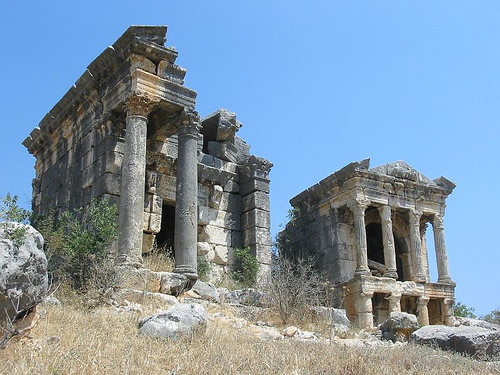
1. Temple of Zeus Olbios
Location: Central, along
the colonnaded street.
Description: Built around 300 BCE, likely by
Seleukos I Nikator, this peripteral temple is surrounded by 36
Corinthian columns (24 still standing), each intricately carved with
reliefs. Measuring approximately 26x15 meters, it is one of Anatolia’s
oldest and largest Zeus temples. The cella (inner chamber) was
destroyed, and in the 5th century, the temple was converted into a
church with added apses and walled columns.
Significance: A symbol of
Hellenistic religious devotion, it reflects the syncretism of Greek Zeus
with the Luwian Tarhu(nt). Its conversion to a church highlights the
region’s Christian transition.
Source:
2. Hellenistic High
Tower
Location: Northeast of the site.
Description: A five-story,
16x13x23-meter tower, built in the 3rd century BCE by Tarkyares. Used as
a residence, treasury, and refuge during attacks, it features internal
compartments and was part of a signaling network using polished shields.
Significance: The tower, the city’s namesake, symbolized Uzuncaburç’s
autonomy and defensive capabilities. Its image appeared on Diocaesarea’s
coins.
3. Roman Theater
Location: East, near the modern
village.
Description: Constructed in the 2nd century CE under Marcus
Aurelius and Lucius Verus, this 2,500–3,000-seat theater is
well-preserved, with a stage and seating area. Its high capacity,
despite the city’s remote location, underscores Uzuncaburç’s importance.
Significance: The theater hosted cultural and civic events, reflecting
Roman urban life. It is currently closed for restoration (as of 2025).
4. Temple of Tyche
Citation:
Location: End of the colonnaded
street.
Description: Built in the late 1st century CE by nobles
Oppius and Kyria, this temple is elevated on five 6-meter granite
columns with Corinthian capitals. An inscription confirms its dedication
to Tyche, the goddess of fortune.
Significance: The temple’s
construction by local elites highlights civic pride and wealth during
the Roman period.
5. Diocaesarea Victory Gate
Location: East
of the city.
Description: A Roman gate from the 1st–2nd century CE,
supported by five 7-meter Corinthian columns with a 1-meter diameter.
Consoles on the columns once held small statues.
Significance: The
gate served as a ceremonial entrance, symbolizing Roman authority and
the city’s prestige.
6. Main Gate
Location: Northwest.
Description: A triple-arched gate with one large central and two smaller
side entrances, well-preserved from the Roman period.
Significance:
It controlled access to the city and showcased Roman architectural
sophistication.
7. Colonnaded Streets
Location: Two
intersecting streets, east-west and north-south.
Description: Dating
to the 1st century CE, these streets were lined with columns (now mostly
fallen) and connected key monuments like the Zeus Temple, Tyche Temple,
and theater. The east-west street begins at the Victory Gate, passing a
nymphaeum (monumental fountain).
Significance: The streets organized
the city’s layout, facilitating commerce and processions, typical of
Roman urban design.
8. Necropolis
Location: Northern valley.
Description: Spanning Hellenistic, Roman, and Byzantine periods, the
necropolis contains thousands of rock-cut tombs and sarcophagi with
intricate carvings. The rocky terrain necessitated carving tombs rather
than burials.
Significance: The necropolis reflects the city’s
religious and artistic traditions, with each tomb showcasing unique
craftsmanship.
9. Pyramidal Mausoleum
Location: South, on a
hill.
Description: A 15-meter-high, 5.5x5.5-meter Doric mausoleum
with a pyramid roof, likely from the Hellenistic period. It is
attributed to a Seleucid or Olba ruler.
Significance: Its unique
architecture distinguishes it in the region, reflecting elite burial
practices.
10. Churches
Location: Scattered, including the
converted Zeus Temple, Stefanos Church (near the tower), a necropolis
church, and a theater-adjacent church.
Description: Built or adapted
in the 5th century, these churches reflect the Christianization of
Diocaesarea. Few traces remain of the smaller churches.
Significance:
They mark Uzuncaburç’s role as a bishopric during the Byzantine period.
Uzuncaburç is a testament to the region’s layered history:
Religious Center: As the Olba Kingdom’s sacred precinct, it was a hub
for Zeus worship, possibly rooted in Luwian traditions. Its later
Christianization reflects religious transitions.
Cultural Syncretism:
The site blends Luwian, Hellenistic, Roman, and Byzantine elements, seen
in inscriptions linking Tarhu(nt) to Zeus and the adaptation of pagan
temples into churches.
Roman Autonomy: Diocaesarea’s coin-minting
rights and monumental architecture highlight its regional importance
under Roman rule.
Preservation: Unlike many Anatolian cities
destroyed by natural disasters, Uzuncaburç’s structures remain intact,
offering a rare glimpse into ancient urban life.
Modern Legacy: The
coexistence of the ancient site and village, with restored Yörük houses,
creates a unique cultural landscape, blending antiquity with rural
traditions.
Historical Context
Hellenistic roots (from ~300 BC): It served as
a major cult center for Zeus Olbios in the Olba Kingdom. The standout
feature is the Temple of Zeus Olbios, a peripteral (column-surrounded)
Corinthian-style temple with ~36 columns (many still standing). It was
later converted into a Byzantine church.
Roman era (from 72 CE):
Emperor Vespasian made it an autonomous city called Diocaesarea. Key
additions include a colonnaded street, monumental city gate (ceremonial
arch), nymphaeum (fountain), Temple of Tyche (goddess of fortune, with 5
columns remaining), and a theater for ~2,500-3,000 people.
Other
highlights: A 22-meter Hellenistic watchtower (the "Uzun Burç" or tall
tower) that gave the modern village its name, rock-cut tombs in the
necropolis, a Byzantine gate, and scattered sarcophagi. Nearby (4 km
east) is Olba proper with aqueduct remains.
The site feels integrated
with the modern village—ruins sit among houses, adding charm.
How
to Get There
By car (recommended): The most flexible option. From
Silifke, head north through villages like Demircili (with ancient tombs
en route), İmamlı, and Keşlitürkmenli. The road is winding but scenic;
the final stretches can be narrow/rough—use a sturdy vehicle and drive
cautiously. From Mersin, it's ~100+ km via the Antalya highway, turning
north at Limonlu.
Public transport: Buses from Silifke run ~3 times
daily (check locally as schedules vary). Taxis or dolmuş (shared vans)
from Silifke are feasible for day trips.
Tours: Day trips from
Mersin, Silifke, or coastal resorts (e.g., Kızkalesi) often combine it
with nearby sites like Heaven & Hell sinkholes (Cennet-Cehennem) or
Kanlıdivane.
Parking: Small lot at the site; free or minimal fee.
Tip: Pair it with Olba, Cambazlı Church, or sinkholes for a full
day. The mountain drive rewards with pine forests and views.
Best
Time to Visit
Spring (April-May) or fall (September-October):
Pleasant temperatures (mild days, cooler evenings), wildflowers or
autumn colors, fewer crowds, and comfortable hiking.
Summer: Hotter
in lowlands but refreshing at altitude; however, peak heat and potential
crowds on weekends.
Winter: Magical with snow on ruins and columns (a
"visual feast"), but roads can be icy, and some areas slippery. Site
remains open year-round.
Visit early morning or late afternoon
for best light on columns and fewer people. Allow 1-2 hours for the main
site, plus extra for walks.
What to See and Do (In-Depth
Itinerary)
Entrance Area & Tower: Start at the Hellenistic tower.
Enter the base (no climbing); it's a defensive/ signaling structure.
Main Ruins: Walk the colonnaded street to the ceremonial gate, fountain,
and Temple of Zeus (courtyard setting is impressive). Nearby: Temple of
Tyche.
Theater: A short walk from the parking lot/main
road—well-preserved with good acoustics.
Necropolis: 10-minute walk
north from the village square (past Atatürk bust) into the valley—rock
tombs and sarcophagi.
Village Exploration: Quiet, authentic—chat with
locals, see how ruins integrate into daily life.
Extension to Olba:
Drive/walk ~4 km for aqueduct and more tombs.
Informational signs
are in Turkish and English. The site is mostly open and walkable on
uneven/rocky paths.
Practical Visiting Tips
Entrance Fee &
Hours: Typically open daily ~08:15-16:45 or similar (box office closes
earlier). Fees around 60-200 TL (varies; Museum Pass/Türkiye valid—check
current rates). Discounts for students/seniors; possible free entry some
days.
What to Bring:
Comfortable walking shoes (uneven ancient
stones, paths).
Water, snacks (limited/no café on-site; picnic in car
or designated area).
Sun protection (hat, sunscreen,
sunglasses)—exposed site.
Layers for mountain temperature shifts.
Camera/phone for photos (columns against sky/mountains are stunning).
Facilities: Basic toilets at ticket area (including Western-style).
No major shops—stock up in Silifke.
Accessibility: Mostly flat
village area but involves walking on ruins; not ideal for severe
mobility issues.
Safety & Etiquette: Respect ruins (no climbing
fragile structures). Site is peaceful—watch for stray dogs or livestock.
Standard Turkey travel precautions apply (e.g., modest dress if entering
any active religious spots, though this is archaeological).
Nearby
Amenities: Picnic area nearby (possible vehicle fee). Limited lodging in
the village; better bases in Silifke or coastal towns.
Combining
with Nearby Attractions
This area shines as part of a Cilician/Mersin
itinerary:
Heaven & Hell Sinkholes (~30 km) — dramatic natural chasms
with a church in one.
Kızkalesi (Maiden's Castle) beach and offshore
fortress.
Silifke — castle, museum, Göksu River delta.
Narlıkuyu —
mosaics and seafood.
Since 2020, excavations led by Dr. Okan Özdemir and Prof. Ümit Aydınoğlu have focused on preservation and restoration, aiming to make Uzuncaburç a “universal archaeological site” and tourism hub. Infrastructure improvements, including roads, signage, and landscaping, have enhanced accessibility. The restoration of three Yörük houses in the village supports a sustainable model, integrating the ancient city and modern settlement for future generations. Social media campaigns and events further promote the site’s cultural richness.