Location: Upper Austria Map
Area: 21,000 hectares
Official site
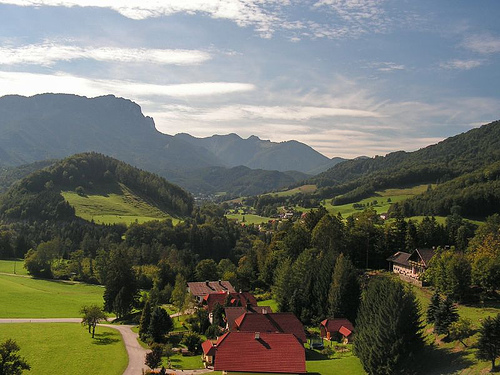
Kalkalpen National Park (Nationalpark Kalkalpen) in Upper Austria
is Austria’s largest forest wilderness and a UNESCO World Natural
Heritage Site for its ancient beech forests. Established in 1997, it
spans about 20,825 hectares (over 51,000 acres) in the Northern
Limestone Alps, protecting the Reichraminger Hintergebirge and
Sengsengebirge ranges.
The park emphasizes minimal human
intervention, featuring primeval beech forests (some trees over 550
years old), karst landscapes, gorges, crystal-clear streams (the
longest intact stream ecosystem in the Northern Limestone Alps),
alpine pastures, and high biodiversity with over 10,000 species of
animals, plants, and fungi.
It offers a true wilderness
experience with well-marked trails but limited infrastructure inside
the core zones—no widespread camping or facilities, emphasizing
"leave no trace."
Best Time to Visit
Spring to late autumn (April/May to October) is
ideal. Spring brings blooming meadows and swelling streams; summer
offers comfortable hiking (20–25°C/68–77°F highs) with lush greenery;
autumn features vibrant foliage and clearer views.
Peak season:
June–August for stable weather, but watch for afternoon
thunderstorms—pack rain gear.
Shoulder seasons (late spring/early
autumn): Fewer crowds, good weather, and lower prices.
Winter:
Possible for snowshoeing or cross-country skiing, but many trails and
access points close due to heavy snow and harsh conditions. Services are
limited.
The park is freely accessible year-round, but stay on marked
paths. Cycling is permitted on approved routes from April 1 to October
31.
Getting There & Transportation
The park lies in Upper
Austria, accessible from Linz (about 1–1.5 hours), Salzburg, Vienna
(around 3 hours by car), or nearby towns like Molln, Windischgarsten,
Reichraming, and Roßleithen.
By car: Easiest option. Main access
points include:
Ennstal (Reichraming/Großraming).
Steyrtal
(Molln/Bodinggraben).
Windischgarstnertal (Windischgarsten,
Roßleithen, Rosenau am Hengstpass).Parking lots exist at trailheads
(some with fees, ~€5–10/day); check signs.
Public transport:
Train to stations like Roßleithen, Reichraming, or Windischgarsten, then
bus, taxi, bike, or hike (local buses are infrequent). Hiking buses or
shuttles operate seasonally (e.g., July–October). Apps like ÖBB Scotty
help plan routes.
Shuttles/Hiking cabs: Available in the region for
trail access.
Visitor Centers & Orientation
Start at a visitor
center for maps, exhibits, weather updates, and ranger advice:
Ennstal Visitor Centre (Reichraming area): Focuses on forest wilderness.
Molln (National Park Allee).
Windischgarsten area, including the
Wurbauerkogel Panorama Tower (21m/69ft high, views of 21 peaks over
2,000m on clear days; accessible by chairlift/hike).
Hengstpasshütte
and others.
Centers offer exhibitions, guided tours, and info on
trails. Download free GPX/KML maps from the official tour portal (via
outdooractive.com). Physical maps (e.g., CARTO.AT No. 401) are
recommended.
Activities & Highlights
Hiking dominates, with
trails for all levels:
Easy/family: Circular walks, alpine pastures,
adventure trails with info panels.
Moderate/challenging: Gorges
(e.g., Triftsteig via ferrata in Große Schlucht), peaks like Hoher Nock
(~2,000m), Wasserklotz.
Long-distance: Kalkalpenweg (150km), Luchs
Trail (lynx-themed), multi-day wilderness crossings with hut stays.
Top experiences include sunrise at Trämpl, beech forest hikes (UNESCO
sites), alpine meadows with butterflies, and ranger-guided tours.
Other activities:
Cycling/mountain biking: 500+ km of trails,
including the scenic Hintergebirgsradweg (old railway tunnels/gorges).
Winter: Snowshoeing, skiing.
Nature observation: Lynx, birds, rare
beetles, forest bathing.
Family-friendly: Visitor centers, easy
paths, playgrounds at Wurbauerkogel.
Accommodations & Overnight
Options
Few options inside the park—wilderness focus means limited
huts/pastures (book ahead for multi-day hikes).
Biwak sites
(May–Oct): Weißwasser and Steyrsteg—basic (fire pit, firewood, compost
toilet, river water). €5/adult, €3/child per night; max 2 nights, ~10
tents. Honor system payment.
Huts/Alms: Seasonal refreshments and
limited beds (e.g., Anlaufalm, Ebenforstalm).
Nearby: Towns like
Windischgarsten (Villa Sonnwend National Park Lodge—comfortable Art
Nouveau), Molln, Reichraming. Camping grounds outside the park.
Essential Tips & Rules
Safety: Alpine terrain—weather changes fast.
Sturdy boots, layers, rain jacket, first aid, enough food/water,
map/compass (cell service spotty). Tell someone your plans. Watch for
falling branches in old forests (use at own risk in windy conditions).
Rules (Leave No Trace):
Stay on marked trails.
No picking plants,
littering, open flames (except designated spots), camping (except
biwaks), drones, canyoning, noise, or motorized vehicles.
Dogs on
leash.
No overnight stays outside permitted areas.
Preparation: Check current conditions/closures on kalkalpen.at. Bring
binoculars for wildlife. Respect wildlife—keep distance.
Costs: Free
entry. Pay for parking, some shuttles, guided tours, biwak fees.
Sustainability: Support local eco-friendly options; the park restores
natural processes.
Pro tips: Visit mid-week for solitude. Combine
with nearby Pyhrn-Priel region. For in-depth exploration, join a ranger
tour or multi-day hike. Always prioritize weather and fitness—trails
range from gentle to strenuous.
Kalkalpen National Park (Nationalpark Kalkalpen), also known in
English as Limestone Alps National Park, is Austria’s largest forest
national park and one of the most significant wilderness areas in the
Alps. Located in the state of Upper Austria (Oberösterreich) within the
Northern Limestone Alps, it encompasses the highly karstified
Sengsengebirge (Sengsen Mountains) and parts of the rugged Reichraminger
Hintergebirge. The park covers approximately 20,850 hectares (about
51,460 acres) and protects Central Europe’s largest contiguous forest
wilderness, with a focus on natural forest dynamics, pristine mountain
streams, alpine habitats, and ancient beech forests.
It was
established as Austria’s first national park in Upper Austria on 25 July
1997 and is managed as an IUCN Category II protected area. Since its
founding, it has gained multiple international designations: Natura 2000
(European protected area under the Habitats and Birds Directives),
Ramsar Wetland of International Importance (2004), and—most
notably—UNESCO World Natural Heritage status in 2017 for its ancient and
primeval beech forests, which form part of the transnational site
“Ancient and Primeval Beech Forests of the Carpathians and Other Regions
of Europe.”
Pre-Park Natural and Human History
The region’s
natural history is tied to the post-glacial ecological development of
Europe. The ancient beech forests within the park represent some of the
best-preserved examples of undisturbed beech ecosystems that have
evolved since the end of the Last Glacial Period. These forests, largely
free of human intervention for centuries in core areas, serve as living
testimony to Europe’s forest history. Today, about three-quarters of the
valuable unexploited beech stands are over 140 years old, with some
trees (like the oldest beech in the Alps) approaching 550 years.
Human presence dates back to the Stone Age. Artifacts from hunters,
including stone tools from 18,000–10,000 BC, have been found in the
Nixloch cave (near Ternberg/Losenstein). Bronze Age finds (axes and a
spear tip c. 1000 BC) in Windischgarsten indicate early use of mountain
passes.
From the early Middle Ages onward, the forests of the Enns
and Steyr valleys—including what is now the park—were heavily exploited.
Wood was harvested for charcoal production to fuel numerous forges
(scythe, knife, hoe, and hammer forges) in the Eisenwurzen
iron-processing region. This intensive use largely eliminated original
old-growth forests, leaving only small remnant islands of primeval
character, especially in inaccessible gorges and high-altitude zones. A
detailed example from the Jörglgraben in the Reichraminger Hintergebirge
shows logging beginning around 1765 for local hammer forges, with phases
of clear-cutting and burning for agriculture until the mid-19th century;
some primeval pockets survived due to their remoteness.
Hunting
reserves of the Counts of Lamberg (and later Archduke Franz Ferdinand as
tenant) helped preserve some areas into the 20th century. In the
interwar period, the Reichraming Forest Railway was built for timber
transport and operated until the early 1970s, but after the decline of
the iron industry (exacerbated by the Great Depression), much of the
landscape remained relatively intact.
Path to Establishment
(1970s–1996)
Modern conservation efforts began in the 1970s amid
growing threats from industrial development. In 1976, the Sengsengebirge
was designated a nature reserve, blocking plans for a pumped-storage
power plant in Breitenau/Molln. Proposals for a military cannon shooting
range (by VÖEST) and additional hydropower projects by Ennskraftwerke
were also floated for the Reichraminger Hintergebirge.
Local and
regional resistance intensified. In February 1983, 35 nature and
environmental associations formed the “Hintergebirge Working Group” to
stop the power plant. Protests, site occupations (echoing the Hainburger
Au conflicts), and a negative environmental impact report led
Ennskraftwerke to withdraw its plans in 1985. The first serious
discussions of a national park in the Reichraminger Hintergebirge
emerged at this time.
A pivotal moment came in September 1989 with
the “Mollner Erklärung” (Mollner Declaration), in which Upper Austrian
alpine clubs and nature conservation groups demanded the creation of an
internationally recognized national park covering the Reichraminger
Hintergebirge, Sengsengebirge, Haller Mauern, Warscheneckstock, and
Totes Gebirge. This was backed by unanimous resolutions from the Upper
Austrian provincial government and broad political support.
Planning
accelerated in 1990: On 2 April, a dedicated planning office opened in
Kirchdorf an der Krems. The “Verein Nationalpark Kalkalpen”
(Association) was founded in May to advocate for the park and IUCN
recognition. Landowners and farmers formed an interest group to ensure
compensation and input via a new “contractual nature conservation”
model. Early proposals for a smaller core zone (10,600 ha in high
altitudes) were expanded to better protect full forest dynamics, stream
systems, and alpine habitats.
On 5 December 1996, the Upper Austrian
Landtag (state parliament) unanimously passed the National Park Act.
Founding, Early Development, and International Recognition
(1997–2010)
In April 1997, the federal government and the province of
Upper Austria jointly established the Nationalpark O.ö. Kalkalpen
Gesellschaft as the operating body (later joined by the Service GmbH in
2004). On 21 July 1997, the park was formally decreed on an initial
16,509 ha; it officially opened on 25 July 1997 in Windischgarsten and
received immediate IUCN Category II recognition.
The park expanded
twice in its early years—to 18,400 ha in 2001 and its current ~20,850 ha
in 2003—through negotiations with landowners (88% federal Austrian
Federal Forests, 11% private, 1% municipal).
Key international
milestones followed quickly:
1998: Nominated as a Natura 2000 site.
2003/2004: Formally designated as a European nature reserve (Natura
2000) and Ramsar wetland (2 February 2004, ref. 1371).
Visitor
infrastructure was developed rapidly: Nationalpark Zentrum Molln (2001),
Villa Sonnwend National Park Hotel (2003, later Lodge), Wurbauerkogel
panorama tower (2005), Ennstal visitor center (2005), and
Hengstpasshütte information point (2009). These facilities support
education, tourism, and sustainable regional development.
UNESCO
World Heritage and Maturity (2011–Present)
In 2017, the park’s
ancient beech forests (specifically in the Urlachtal, Bodinggraben,
Wilder Graben, and Hintergebirge areas) were inscribed on the UNESCO
World Heritage List—making Kalkalpen (together with the Dürrenstein
wilderness) Austria’s first natural World Heritage site. This
recognition highlights their role in Europe’s post-glacial forest
history.
The park celebrated its 10th anniversary in 2007, 20th in
2017 (with regional expansion to 18 municipalities), and 25th in 2022. A
30-year double anniversary (park founding + 10 years UNESCO) is planned
for 2027.
Recent developments include participation in the Austrian
National Parks strategy (2010 and 2020+), the “Netzwerk Naturwald”
biotope network for connectivity, and stepping-stone habitats. The
COVID-19 pandemic (2020) temporarily closed facilities, but the park
rebounded. In 2021, the State Court of Auditors reviewed operations
positively. Ongoing management emphasizes non-intervention in ~89% of
the area (the nature zone), allowing natural processes to restore
primeval forest characteristics over generations.
Kalkalpen National Park (Nationalpark Kalkalpen, literally "Limestone
Alps National Park") is one of Austria's most pristine wilderness areas,
located entirely within the Northern Limestone Alps in the southeastern
part of Upper Austria. Established in 1997, it protects approximately
20,850 hectares (about 208.5 km² or 51,500 acres) and is renowned as
Austria's largest contiguous forest wilderness and its most significant
karst landscape. It forms part of a larger protected complex, including
Ramsar wetland status (designated 2004) and UNESCO World Heritage
recognition for its ancient beech forests (alongside other European
sites since 2017).
The park lies roughly at coordinates 47°47′N
14°22′E, centered about 25 km south of Kirchdorf an der Krems and 35 km
from Steyr, in a transitional zone between the Alpine foreland and
inner-Alpine basins. It is surrounded by towns such as Windischgarsten,
Roßleithen, Reichraming, and Großraming, with the Enns Valley and
Pyhrn-Priel region nearby.
Topography and Mountain Ranges
The
park encompasses two distinct mountain groups that create a highly
varied relief with significant elevation differences and "high relief
energy" (steep slopes and dynamic erosion processes).
Sengsengebirge: This is a northern outpost of the Limestone Alps,
forming a prominent, roughly 20 km long main ridge with a more alpine
character. It features jagged crests, plateaus, and dramatic peaks. The
highest point in the park is Hoher Nock (1,963 m / 6,440 ft), a
distinctive summit offering panoramic views. Other notable peaks include
Gamsplan (1,902 m), Schneeberg (1,889 m), Seekopf (1,845 m), and
Hochsengs (1,838 m). The range is highly karstified, with exposed rock,
sinkholes, and alpine pastures at higher elevations.
Reichraminger
Hintergebirge: This is a more rugged, densely forested "sea of forest"
with fewer roads or human intrusions. It features deep, hidden gorges,
canyons, steep valleys, and a maze of streams. The terrain here is
dissected by erosion, creating a labyrinth of valleys that historically
supported limited timber rafting but now remain largely untouched in the
core zones.
Overall elevation ranges from about 385 m (valley
floors) to 1,963 m at the summit of Hoher Nock. The landscape includes
sharp ridges, dramatic abysses, karst plateaus, and avalanche-prone
slopes. From viewpoints like the Wurbauerkogel panorama tower (near
Windischgarsten) or Wasserklotz (1,505 m), visitors can see dozens of
2,000 m+ peaks stretching toward the Ötscher and Großer Priel.
The
park contains 137 named mountains and is characterized by diverse
landforms typical of the "Kalkhochalpen" (High Limestone Alps): crests
alternating with deep valleys, and a mix of forested slopes and rocky
outcrops.
Geology
Kalkalpen lies in the Northern Limestone
Alps, built primarily of Mesozoic (Triassic-Jurassic) sedimentary
rocks—chiefly Wetterstein limestone and primary dolomite. These rocks
are highly soluble, leading to Austria's largest and most developed
karst region.
Karst processes dominate: rainwater infiltrates rapidly
through fissures, creating extensive underground drainage systems, caves
(over 70 documented, including the deep Krestenbergschacht at 412 m and
ice caves like the Eiskapelle in the Sengsengebirge), sinkholes
(dolines), shafts, and pipe-like conduits. Surface features include
rocky rubble fields and exposed limestone pavements. This geology
produces the "moated castle" effect—abundant water emerging as springs
while much of the drainage is subterranean.
Erosion by water (since
the Alpine uplift) combined with frost action and mass movements has
sculpted the gorges, canyons, and dynamic slopes that define the park's
wilderness character.
Hydrology and Water Systems
Water is the
defining geographic force here. The highly karstified terrain supports
one of the longest intact natural stream ecosystems in the Northern (or
Eastern) Limestone Alps, with over 200 km (124 miles) of streams and a
catchment area of about 40,000 ha.
Springs: More than 800
documented springs, many giant karst springs (e.g., Vorderer and
Hinterer Rettenbach in the Sengsengebirge) that can discharge thousands
of liters per second during snowmelt or heavy rain. These cold,
oxygen-rich waters host unique micro-habitats with Ice Age relict
species.
Major streams: Two primary free-flowing systems—the Großer
Bach (in the Hintergebirge) and Krumme Steyrling—form a ramified network
of clear, high-purity brooks. Many are dynamic, with natural
floodplains, cascades, and boulder-strewn beds.
Other waters: Small
lakes and ponds (e.g., Große Feichtausee, the only true lake, plus
shallower ones like Kleine Feichtausee and Herzerlsee), plus bogs and
peatlands in poorly drained areas. Underground karst aquifers feed
surface waters and supply surrounding regions.
The park's
designation as a Ramsar Wetland highlights its global importance for
hydrological and biodiversity values. Water quality remains
exceptionally high due to minimal human impact.
Land Cover and
Broader Landscapes
Land cover breaks down as roughly:
81% forest
(the dominant feature; ~30–32 forest communities, including ancient
beech forests on 5,250 ha—one of the largest reserves in the Alps, with
trees over 550 years old).
8% mountain pine shrubland.
6% alpine
pastures and meadows.
5% rock and rubble.
The forests create a
vast "green wilderness" with high deadwood stocks, supporting natural
dynamics. Non-forest areas include avalanche tracks, dwarf pine stands,
and open karst terrain. The combination of dense canopy, hidden gorges,
crystal-clear streams, and high peaks gives the park its mosaic of
habitats.
Climate
The climate is alpine/montane and humid,
with frequent heavy precipitation (1,300–1,800 mm annually, up to 2,500
mm at higher elevations). Microclimates vary sharply due to relief,
aspect, and altitude: cooler, wetter northern exposures versus more
continental southern basins. Snow cover persists at higher elevations
into spring, influencing hydrology and vegetation.
Overall Plant Diversity
Biotope mapping completed in 2015 recorded
1,090 plant species (vascular plants, mosses, and lichens) — roughly
one-third of all plant species found in Austria. Vascular plants alone
number around 927–1,090 depending on the exact count, with 42 species of
wild orchids making it one of the richest orchid sites in the Alps.
Many species are rare, protected, or on Red Lists (102 vascular plants
are endangered in Upper Austria). The park also harbors at least 14
north-eastern Alpine endemics or sub-endemics, plants that occur nowhere
else or almost nowhere else in the world.
Woody Plants: Trees and
Shrubs
The park is famously a forest national park (about 81 % forest
cover). It contains 32 native tree species — exactly half of Austria’s
65 native trees — and over 50 shrub species. Critically, no alien
(neophyte) tree species occur here; the woody flora is entirely natural.
Dominant forest type: Spruce–fir–beech (Fichten-Tannen-Buchenwald),
but the park supports six different beech-forest communities and a total
of about 30 forest communities overall. These range from lowland
ravine/slope forests (maple–ash–elm–lime) and riparian alder–ash forests
to bog forests and high-montane spruce stands.
Beech (Fagus
sylvatica) is the flagship species. The park contains some of Europe’s
largest and oldest primeval beech forests, now part of UNESCO World
Natural Heritage (together with other European beech sites). Monumental
beeches reach 45 m height and 2 m trunk diameter; the oldest known
continental beech dates to 1473 (over 550 years old). Deadwood volumes
are exceptionally high, supporting rich fungal, moss, and lichen
communities.
Other key trees: Mountain maple (Acer pseudoplatanus),
common ash (Fraxinus excelsior), mountain elm (Ulmus glabra),
serviceberry (Sorbus aria), mountain ash (Sorbus aucuparia), European
yew (Taxus baccata), larch (Larix decidua), spruce (Picea abies), and
mountain pine (Pinus mugo — forming krummholz scrub at higher
elevations).
Shrubs include four honeysuckles, seven wild roses, wild
currants, two junipers, and the attractive rock pear (Amelanchier
ovalis), which produces showy white spring blossoms.
Vascular
Plants and Flowering Plants
Flowering plants thrive in forests,
alpine meadows, pastures, mountain pastures (Almen), rocky outcrops,
scree slopes, and gorges. Calcareous soils favor many lime-loving
specialists.
Selected iconic and rare species (all preferring
calcareous substrates and some restricted to the north-eastern Limestone
Alps):
Snow rose (Helleborus niger, also called Christmas rose) —
An Eastern Alps endemic. It can bloom as early as December in mild
winters; large white flowers emerge directly from snow-covered ground.
Clusius primrose (Primula clusiana, locally “Jagablut”) — Striking
purple-red petals; blooms late April to June. One of the classic
north-eastern Alpine endemics.
Yellow lady’s slipper (Cypripedium
calceolus) — The park’s most famous orchid; large lemon-yellow
slipper-shaped lip (up to 4 cm). One of 42 orchid species; strictly
protected and currently being mapped.
Eastern Alps gentian (Gentiana
clusii or related taxa) — Large, deep blue-purple flowers on
nutrient-poor meadows and tall-herb communities.
Turk’s cap lily
(Lilium martagon) — The most striking forest flower; up to 1 m tall with
fragrant, turban-shaped pink-purple blossoms. Grows in semi-shade in
beech and mixed forests.
Additional notables include wild garlic,
great aster, fire lily, rock pear blossoms, and various anemones. Alpine
meadows and former pastures are especially flower-rich, supporting
butterflies, bees, and other pollinators.
Non-Vascular and
Cryptogamic Flora
The old-growth character of the forests creates
ideal conditions for:
Mosses and liverworts (colorful variants
visible on deadwood and rocks).
Ferns (e.g., deer-tongue fern
Asplenium scolopendrium).
Lichens and a spectacular diversity of
fungi (e.g., fire scaly fungus on deadwood). Over 6,000 total species of
animals, plants, and fungi have been recorded park-wide, with fungi and
cryptogams particularly diverse in the primeval beech stands.
Ecological Context and Conservation
The park’s limestone karst
landscape creates a mosaic of micro-habitats: dry rocky ridges, moist
gorges, scree slopes, and small wetlands. Altitude and aspect produce
strong gradients — from montane forests to subalpine krummholz and
alpine pastures. Because most of the park has been left to natural
processes since its establishment in 1997 (with large wilderness zones),
forests are returning to primeval structure: uneven-aged, multi-layered,
with high deadwood and natural regeneration.
This dynamic wilderness
supports not only high plant diversity but also many endangered and
endemic species. The beech forests in particular are a living laboratory
of European forest ecology and were inscribed on the UNESCO World
Heritage List in 2017 for their outstanding universal value.
Kalkalpen National Park (Nationalpark Kalkalpen) in Upper Austria is
one of Central Europe’s most important wilderness areas, protecting the
largest continuous stretch of near-natural beech and mixed forests in
the Northern Limestone Alps. Its karst landscapes, deep gorges, clear
mountain streams, alpine pastures, and old-growth forests (including
ancient beech stands up to 546 years old) create a refuge for
exceptional faunal diversity. Over 10,000 species of animals, plants,
and fungi have been recorded, making it a biodiversity hotspot and part
of the UNESCO World Heritage site for ancient beech forests.
The park
spans altitudes from about 385 m to 1,963 m, with 87% forest cover and
large wild zones free from human interference. This allows natural
processes like deadwood accumulation, floods, and windthrows to
thrive—key for many specialized species. Reintroductions and natural
returns of large predators (lynx, otter) and raptors have restored
ecological balance.
Mammals (55 species, including 17 bats)
The park supports a rich mammalian fauna, dominated by forest and
mountain species. Bats form the largest group (17 species), with
forest-adapted ones like Bechstein’s bat and the pug bat characteristic;
the lesser horseshoe bat is of supra-regional importance due to its
roosts.
Iconic large mammals include:
Eurasian lynx —
Austria’s only stable population in the Alps (reintroduced in the late
1990s after extirpation). Small but established (several territories,
e.g., named individuals like Skadi, Luzi), it is a secretive apex
predator that helps regulate ungulate populations naturally. Camera
traps and tracks confirm its presence; it symbolizes wilderness
recovery.
Red deer — The largest free-living herbivore in Central
Europe; common and observable (e.g., in Bodinggraben valley or during
the autumn rut).
Chamois — Typical of steeper terrain, especially in
the Sengsengebirge mountains.
Roe deer, pine marten, and otter
(recent natural returnee).
Alpine ibex, marmots, and wildcats are
absent due to the park’s geomorphology and heavy winter snow.
Birds (115 species documented; ~80 breeding)
The park is a stronghold
for forest and mountain birds, with many endangered species breeding in
high densities thanks to abundant deadwood and intact habitats. At least
24 species are listed in Annex I of the EU Birds Directive; 39 of the
montane/subalpine breeders are endangered in Upper Austria.
Standout species:
White-backed woodpecker — The rarest woodpecker in
Austria and a primeval-forest indicator (strictly tied to heavy
deciduous deadwood). High population (110–130 breeding pairs) makes the
park one of its most important European sites. All six Austrian
woodpecker species occur here.
Golden eagle — Largest breeding raptor
in the Northern Limestone Alps; eight territories/pairs, with young
birds often seen.
Other notables: Tengmalm’s (boreal) owl, pygmy owl,
great horned owl, lesser spotted (red-breasted) flycatcher, collared
flycatcher, capercaillie, black grouse (courtship displays in spring),
peregrine falcon (returned), and recent arrival black stork. Honey
buzzard and various songbirds also thrive.
Amphibians and
Reptiles
Amphibians: Seven species confirmed. The most widespread are
grass frog, Alpine newt, and common toad. Notable protected or important
species include the yellow-bellied toad (supra-regional/international
importance, Annex II Habitats Directive) and Alpine salamander
(live-bearing, no aquatic larval stage; local name “Bergmandl”). Others:
pond newt, fire salamander, and common toad. Three more species occur
nearby.
Reptiles: Seven of Upper Austria’s ten native species.
Characteristic include the smooth snake (harmless, often confused with
adder), adder (only venomous snake; variable colors including black
“hell vipers” and red “fire vipers”), sand lizard (thermophilic, high
altitudes), and mountain lizard (small, common on pastures). No
tortoises.
Fish and Aquatic Fauna
Mountain streams and rivers
(over 200 km protected) host native fish. Key species: autochthonous
Danube brown trout (the only remaining original strain in Upper
Austria), grayling (in valley streams), and bullhead. Non-native trout
and minnows have been actively removed to restore natural communities.
Stone crayfish inhabit the clear, cold waters. Springs and karst systems
support specialized invertebrates.
Invertebrates (exceptionally
diverse)
Insects dominate the park’s biodiversity. Butterflies and
moths: Over 1,610 species recorded (highest in any Austrian protected
area), including rarities like the Alpine mat fritillary and Imperial
Cloak. Many find refuge in gorges, meadows, and alpine habitats.
Beetles: Enormous diversity, with dozens of primeval-forest relict
species (41 confirmed) dependent on deadwood. Highlights include the
Alpine longhorn beetle (Rosalia alpina, a “flying jewel” and
EU-protected species, one of Austria’s strongest populations here) and
the endemic cave ground beetle (Arctaphaenops muellneri, blind and
wingless, found almost exclusively in the park’s caves).