Location: Carinthia
Burgruine Gradenegg, also known as Gradenegg Castle, is a ruined hill castle (Höhenburg) situated in the municipality of Liebenfels in the district of Sankt Veit an der Glan, Carinthia, Austria. It occupies a strategic position on a low, rocky hilltop approximately 300 meters above the Glantalboden valley floor, at an elevation of 994 meters above sea level. The castle's geographical coordinates are 46° 45′ 48″ N, 14° 14′ 36″ E. This location provided natural defenses and oversight of the surrounding area, typical of medieval fortifications in the region. The site is near other historical landmarks, including Schloss Liemberg (about 1.74 km away), Wehrkirche Sörg (2.47 km), Burg Alt-Liemberg (2.60 km), Burg Liebenfels (3.07 km), Schloss Hohenstein (4.09 km), Schloss Rosenbichl (4.33 km), and Burg Schaumburg (4.72 km), highlighting Carinthia's rich density of medieval structures.
Early History: The Lords of Gradenegg (12th–15th Centuries)
The
castle’s documented history begins on 27 May 1192, when Rudlandus de
Gradnich (or Grednich) is attested as a ministeriale of the Duke of
Carinthia in a deed issued by Bishop Dietrich I of Gurk. The family name
likely derives from a Slavic (Slovenian) root, reflecting the region’s
mixed linguistic heritage. Additional early references include Conradus
de Gradwin (1206) and Berenhardus de Grednik (1245).
The Herren von
Gradenegg (Lords of Gradenegg) were a prominent Carinthian ministerial
family. Local legend (undocumented in formal charters but noted in
historical accounts) associates them with the hereditary “mowing right”
(Erbmährecht): during the ceremonial installation of a new Carinthian
duke on the stone throne (Herzogstuhl) at Maria Saal, they were
supposedly entitled to mow grass on any lands in the duchy. This
folklore underscores their high status among regional nobles.
The
family retained the estate until Reinprecht von Gradenegg, the last
direct representative, held it in 1436. After this, the line appears to
have ended or merged through marriage/inheritance.
Later
Ownership Transitions (15th–17th Centuries)
Ownership passed through
several Carinthian noble families, often via purchase, marriage, or
enfeoffment:
1463: Christoph Ungnad von Sonnegg (possibly related
to the original Gradenegg line).
1553: Andrä Mordax.
1566: Wolf
Dietrich Freiherr von Thannhausen (acquired through marriage).
1578/1581: Freiin Walburga von Egkh-Hungersbach; the castle was
enfeoffed to the Freiherr zu Egck und Hungersbach.
1631: Following
confiscation (likely tied to Protestant owners during the
Counter-Reformation), it was sold for 17,000 gulden to Anton d.J.
Freiherr von Grottenegg and Paul Freiherr von Khevenhüller. The
Protestant Khevenhüller later emigrated and sold his share.
1644:
Hans David Seenuß zu Pach acquired it from Salome von Grotta; his
descendants transferred it in 1674 to Franz Freiherr von Aschau.
1680: Franz von Aschau died and was buried in the local Gradenegg church
(his gravestone survives).
1686: His widow Susanna-Katharina passed
the estate to their daughters, Maria-Benigna Freifrau von Radowsky and
Maria Theresia Freifrau von Lang.
Decline likely began soon after
1686 as the castle lost strategic and residential importance.
18th–19th Centuries: Earthquake Damage and Agricultural Reuse
In
1732, the estate was purchased by Johann Anton Oswald Graf Goess, whose
family held it until 1936. In 1787, Carinthian historian Franz Xaver
Kohla recorded the discovery of Roman copper and silver coins near or
within the castle ruins, along with evidence of ancient mining activity
in the area—hinting at possible pre-medieval settlement or Roman-era use
of the site.
The decisive blow came in 1796 with a severe earthquake
that struck Carinthia. The castle was badly damaged (particularly the
south palas section), and it was thereafter repurposed solely as stables
and farm outbuildings for the neighboring estate. A now-lost
mid-19th-century drawing by artist Markus Pernhart shows the complex
still largely roofed but already decaying. By the late 19th century, the
roofs had vanished, and vegetation began reclaiming the walls.
20th Century to Present: Protected Ruins Under Private Ownership
In
1936, the Goess family sold the property to Roman Mulle (owner of the
Gasthof Grüner Baum in nearby St. Veit an der Glan). His descendants
remain the owners today. The site is listed as a protected cultural
heritage monument (ObjektID 34608) but receives no public funding for
restoration and is not developed for tourism. It lies on private pasture
land (free-roaming cows are common), and visitors are welcome upon
polite request, though the terrain is uneven and inaccessible for
wheelchairs.
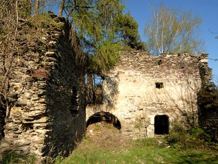
Overall Layout and Site Integration
The castle complex is modest
in scale and efficiently arranged on the constrained rocky terrain.
Buildings are laid out at roughly right angles within a perimeter
enclosure, creating distinct functional zones:
A central/eastern
defensive and economic core around the bergfried (keep).
A western
residential wing (the palas), deliberately separated from the utility
buildings for security and privacy.
All enclosed by a continuous ring
wall.
Natural topography enhances the artificial defenses: steep
drops on the sides and a substantial Halsgraben (neck ditch/moat cut
into the spur) protecting the northern approach and entrance. This zonal
design—typical of smaller Carinthian hill castles—optimizes defense,
economy, and later residential comfort within a limited footprint. The
entire site is now private property (used as pasture) and heavily
overgrown with young forest and vegetation.
Bergfried (Keep): The
Romanesque Defensive Core
The most prominent and best-preserved
feature is the massive square bergfried, dating to the late 12th–13th
century (Romanesque period). It measures 11 × 11 meters at the base with
walls up to 2.5 meters thick, built of local stone for maximum solidity
against sieges.
Key architectural details include:
Narrow slit
windows (light slits for illumination and archery) — two per floor on
the south and east faces, each about 80 cm long.
Original entrance
elevated 6 meters above ground level on the west side (a classic
anti-breach feature, accessible only by ladder or drawbridge).
A
later ground-level doorway was breached once the castle’s military role
declined.
The north side has collapsed.
This tower served as
the primary stronghold, refuge, and watchtower, embodying early medieval
defensive architecture with its thick, windowless lower levels and
minimal openings higher up. It anchors the complex, with later buildings
grouped around it while maintaining defensive spacing.
Palas
(Great Hall / Residential Building)
Separated to the west from the
economic zone is the three-storey palas, originally part of the
12th–13th-century core but extensively remodeled and enlarged in the
early 16th century. It measures approximately 21 × 9 meters and attaches
to the northern ring wall (its southern section has partially collapsed,
likely from the 1796 earthquake).
Renaissance upgrades are evident in
the marble frames around windows and doorways, signaling a shift toward
greater residential comfort and status display rather than pure
fortification. This evolution reflects broader 16th-century trends in
Austrian noble architecture, where defensive cores were adapted for more
palatial living. The palas provided halls and chambers for the lords,
contrasting with the utilitarian eastern buildings.
Outbuildings
and Economic Structures
Clustered around the bergfried are 14th- and
15th-century utility buildings (stables, storage, and farm structures).
These supported the castle’s economic self-sufficiency (e.g.,
agriculture and livestock) while preserving open defensive spacing from
the keep.
Constructed of the same local stone as the rest of the
complex, they were later adapted for ongoing farm use post-earthquake.
Today, only ruined walls remain, often overgrown. Their functional,
unadorned design prioritizes practicality over ornamentation.
Fortifications: Ring Wall and Perimeter Defenses
The entire complex
is enclosed by a high Gothic ring wall (curtain wall) erected in 1455,
which defines the outer boundary and adds a layered defensive perimeter.
It features small corner towers, notably the Eckturm in the northeast
for flanking fire and oversight.
The wall integrates with the natural
cliffs and the northern Halsgraben, creating a formidable barrier
despite the castle’s modest size. Access was (and remains) from the
north, funneled through the ditch for controlled entry. This
15th-century addition represents a late-medieval response to evolving
threats, upgrading the original 12th-century core without major redesign
of the interior layout.
Materials, Construction Techniques, and
Style Evolution
Materials: Predominantly local Carinthian stone
(irregular rubble masonry with some dressed elements), chosen for
durability and availability. Marble was imported or quarried for the
16th-century palas openings.
Techniques: Thick, load-bearing walls
with minimal openings in the early phases; later periods introduced
larger windows and refined framing. No advanced vaulting or ornate
interiors survive due to ruinous condition, but the overall construction
emphasizes solidity over decoration.
Styles:
Romanesque (12th–13th
c.): Massive, austere bergfried focused on defense.
Gothic (15th c.):
Ring wall with functional corner towers.
Renaissance (16th c.): Palas
remodel with elegant marble detailing for comfort.
Today, Burgruine Gradenegg remains in a state of advanced ruin and decay, primarily consisting of the preserved bergfried, ring walls, and remnants of the palas and outbuildings. It no longer functions as a residence or defensive structure and is not actively maintained for tourism, though it serves as a historical site accessible to visitors interested in medieval ruins. The 1796 earthquake marked the beginning of its irreversible decline, and subsequent centuries of neglect have left it vulnerable to the elements. While not a major tourist attraction like some restored Austrian castles, its remote and atmospheric setting offers a glimpse into Carinthia's feudal past.
Among its standout features are the imposing Romanesque bergfried, the marble-adorned 16th-century palas, the Gothic ring wall, and the defensive neck ditch, which together illustrate the castle's layered architectural history. The discovery of Roman artifacts in 1787 adds an intriguing prehistoric dimension, potentially linking the site to earlier Roman mining or settlement activities in Carinthia. The castle's significance lies in its representation of ministerial castles in medieval Austria, built by lower nobility under ducal authority. It stands as a testament to the region's turbulent history, including natural disasters like the 1796 earthquake, and contributes to the cultural heritage of Liebenfels. For those exploring Carinthia, it pairs well with nearby sites for a broader understanding of local fortifications.