Location: Vorarlberg Map
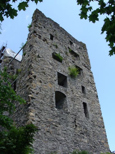
Burgruine Neu-Montfort, also known as Burg Neu-Montfort or Neu-Montfort Castle Ruins, is a medieval hilltop castle ruin located in the Austrian state of Vorarlberg. Constructed in the early 14th century by the noble Counts of Montfort-Feldkirch, it served as a fortified residence and strategic outpost overlooking the Rhine Valley. The castle exemplifies simple yet robust medieval architecture typical of the region, designed for defense amid the turbulent politics of the Holy Roman Empire. Though it fell into disrepair by the late 17th century and remains a ruin today, it has undergone periodic restorations and archaeological investigations, preserving its historical value as a landmark of local heritage.
Location
The ruins are situated near the town of Götzis in the Feldkirch district of Vorarlberg, western Austria, close to the borders with Switzerland and Liechtenstein. Specifically, they perch on the northeastern foothills of the Therenberg mountain, at an elevation of approximately 513–516 meters (1,683–1,693 feet) above sea level. The coordinates are 47°19′41″N 9°38′42″E. This elevated position provides commanding panoramic views over the Rhine Valley toward Lake Constance (Bodensee), making it a scenic vantage point. The site is accessible via hiking paths from Götzis, integrating it into the region's natural landscape of rolling hills and alpine terrain.
Construction and Early History (Early 14th Century)
The Counts of
Montfort (specifically Rudolf III and Ulrich II of Montfort-Feldkirch)
built the castle between 1311 and 1319. The first documented mention
dates to 1319.
It was likely constructed on the site of an earlier
fortress, possibly belonging to the Welfen (Guelphs), which had been
destroyed before 1269. The new castle replaced this older structure as a
strategic stronghold.
Neu-Montfort is a relatively simple, compact
highland castle. Its core consists of:
A massive, five-story
residential tower (bergfriedartiger Wohnturm) with a high entrance on
the northeast side at the level of the second floor.
A palas
(residential building) attached to the west, which has largely
disappeared.
This design emphasized defensibility and residential
use in a compact footprint typical of smaller noble fortifications in
the region.
Transition to Habsburg Control (Late 14th Century)
Around 30–50 years after construction (sources vary slightly between
~1363 and 1390), the Montforts sold their holdings, including the
castle, to the Habsburgs. This transaction marked the Habsburgs' first
territorial foothold in Vorarlberg, highlighting the castle's strategic
importance in consolidating power in the Alpine Rhine Valley region.
Role in the Appenzell Wars (1405–1408)
During the Appenzell Wars,
forces of the Bund ob dem See (a league including Appenzell) occupied
Neu-Montfort and used it as a stronghold. Notably, unlike many other
castles in the area that were destroyed by the Appenzellers,
Neu-Montfort survived relatively intact. After the war ended in 1408, it
returned to Habsburg control.
Subsequent political turmoil followed:
After the banishment of Duke Frederick IV of Austria (the "Pocket
Duke"), Emperor Sigismund seized the fief and granted it temporarily as
a pledge to the Counts of Nellenburg and later (1417) to Frederick of
Toggenburg. It returned to Habsburg hands by 1436, though they often
pledged it to local administrators.
Later Use and Decline
(15th–17th Centuries)
The castle served primarily as an
administrative center and residence for Habsburg-appointed officials
(Vögte or Burgverwalter). Significant modifications occurred under
officials like Eitel Hans Gienger, Vogt of Feldkirch.
By the late
17th century, its military and administrative relevance had waned. The
last resident administrator, Ulrich Koch, died in 1693, after which the
castle was largely abandoned and began to fall into disrepair.
18th–20th Centuries: Ruination and Early Preservation
The structure
decayed naturally. Major collapses occurred in the third quarter of the
19th century, when parts of the residential tower fell. Early
20th-century efforts included initial stabilization work in 1913.
Further repairs happened after World War I and in the 1960s–1970s.
In
1970 and 1974/75, the outer ring wall was restored. Despite these
efforts, decay continued; a 1992 collapse of a southeast window and
earthquake damage led to the tower area being closed to the public in
1998 for safety.
Modern Era and Archaeology (21st Century)
The
ruin is owned by the municipality of Götzis, which has worked to
preserve it as a cultural heritage site and local landmark.
Archaeological excavations in 2020 uncovered significant finds,
including:
Decorated tiles from a 15th–16th century tiled stove.
The cellar of the palas, which was excavated and documented.
Ongoing
conservation efforts aim to stabilize the structure for future
generations.
Overall Layout and Design
The castle followed a compact,
minimalist design typical of early 14th-century Montfort fortifications
in the region. It emphasized defensive efficiency on rugged terrain
rather than expansive grandeur. The core complex included:
A central
bergfried (residential tower).
An attached palas (palace/residential
wing) to the west.
Encircling ring walls with limited access points.
This created a self-contained hilltop bastion that leveraged natural
steep slopes for defense, with a defensive ditch on the more vulnerable
southern side (about 12m wide and 2–3m deep). The layout allowed for
potential future expansions while maintaining a small footprint suited
to the spur's topography.
The design integrated living quarters with
military functions, reflecting the transitional needs of feudal lords in
contested borderlands.
The Residential Tower (Bergfried /
Wohnturm)
The most prominent and best-preserved feature is the
massive residential tower, a classic bergfried—a tall, fortified tower
common in German-speaking medieval castles that combined defensive and
residential roles.
Key features:
Dimensions: Approximately 12
x 13.5 meters at the base, originally around 24 meters tall (roughly
five to six stories).
Walls: Exceptionally thick megalithic masonry,
up to 2.2 meters (about 7.2 ft) thick, built with hewn local stone and
mortar/clay-pebble fills on bedrock for stability.
Entrance: High
entrance on the northeastern side at the second-floor level — a
defensive hallmark requiring ladders or wooden walkways (wehrgang),
which also encircled parts of the structure for observation and defense.
Interior: Multi-level living quarters with light slits (later enlarged
into windows in the 16th century for better habitability). Evidence of
comforts like tiled stoves exists.
Current state: Outer walls survive
to about five stories, making it the dominant visual landmark despite
partial collapses in the 19th century.
The tower provided
surveillance over the Rhine Valley and served as a final refuge. Its
robust construction helped it survive events like the Appenzell Wars
(1405–1408) relatively intact.
The Palas (Palace Complex)
Attached to the western side of the tower, the palas served as the
primary residential, administrative, and domestic hub. It contrasted the
tower's austere defensiveness with more comfortable living spaces.
Architectural details:
Basement cellars (excavated and revealed in
2020–2021 archaeology): Three interconnected vaulted rooms — a
rectangular entrance/staircase area (3.5 x 4.5 m), a long storage space
(approx. 4.8m wide x 12.1m long), and a trapezoidal chamber (4.4 x
5.4–7.7m). These used hewn stone foundations on bedrock with mortar
fills and vaulted ceilings supporting upper floors. Used for wine
storage and access.
Upper floors: Halls, chambers, kitchen with
baking oven, servant quarters, and additional living spaces. Staircases
connected levels.
Interior features: 15th–16th century green-glazed
stove tiles (Ofenkacheln) with Renaissance motifs (leaves, arabesques,
dolphins, hybrid creatures, gables) indicate up to four heated rooms for
nobility. Later additions included enlarged windows and a bathhouse
(1564–1574).
Construction: Built concurrently with the tower
(1311–1319), with 14th–16th century modifications under Montfort and
Habsburg ownership.
The palas highlights the castle's evolution from
pure stronghold to administrative residence.
Defensive Elements
and Fortifications
Ring walls: Eastern wall ~67m, western ~46m, built
of local stone on bedrock with a single narrow eastern gate (about 2m
wide). Integrated with natural topography; remnants are visible.
Additional defenses: Southern ditch for added protection; possible
crenellations and a wooden walkway (wehrgang) along the tower; a lower
road barrier/toll gate (now gone) controlled valley access.
Materials
and techniques: Heavy use of local stone masonry suited to the Alpine
foothills, with adaptations for terrain rather than elaborate moats or
multiple baileys.
The architecture prioritized terrain-integrated
defense over complexity, making it resilient but not impregnable against
prolonged neglect.
Later Modifications and Current State
16th-century renovations under Habsburg vögte (e.g., Eitel Hans Gienger)
focused on habitability: expanded palas features, more windows, and
stoves. The castle declined after 1693 (death of last resident Ulrich
Koch), leading to ruin by the 19th century. 20th-century stabilizations
(1913, 1960s–1970s) and recent archaeology have preserved key elements,
though parts remain restricted for safety.
Overall character:
Neu-Montfort exemplifies compact 14th-century regional castle
architecture — functional, defensively oriented, and adapted to its
hilltop site. It blends military robustness (thick tower walls, high
entrance) with evolving residential comfort (palas amenities),
reflecting shifts from Montfort feudal control to Habsburg
administration. Today, the ruins stand as a picturesque landmark
accessible by hiking trails, with the tower walls still imposing against
the landscape.
Location and Access
Address: Montfortstraße area, 6840 Götzis,
Vorarlberg, Austria.
Coordinates: Approx. 47.328°N, 9.645°E.
It's
a short uphill hike (roughly 1–2 km / 20–40 minutes) from Götzis town
center or parking areas below the hill.
Getting There:
By car:
Easy access from the A14 motorway. Follow signs to Götzis and then
Montfortstraße. Free parking is available at the base of the hill.
Public transport: Götzis has a train station (good connections from
Feldkirch, Bregenz, or Dornbirn). From the station or town center,
follow well-marked trails uphill.
By bike: Feasible via local paths;
the area integrates well with regional cycling routes.
The site
is open year-round with no official opening hours or entrance fees for
exterior viewing. It is freely accessible.
Visiting Tips
Best
time to visit: Daytime for safety and views. Spring through autumn
(May–October) is ideal for pleasant weather and clear panoramas. Early
morning or late afternoon often provides the best light and fewer
people. Summers can be warm, but the forested path offers shade.
Duration: 1–2 hours for a relaxed visit including the hike up/down and
time at the ruins. Combine with a longer hike for half a day.
Difficulty: The ascent is relatively easy to moderate — suitable for
most fitness levels and families. Paths are well-marked but can be
steep, uneven, or slippery after rain. Wear sturdy hiking shoes with
good grip.
What to expect at the site: You can explore the base and
around the tower. Parts (like the tower interior or certain areas) may
be restricted due to ongoing or periodic renovations/restoration work —
check locally or online before going if you want full access.
Views:
The main highlight is the fantastic panoramic vista over the Rhine
Valley and toward Lake Constance. It's especially rewarding after the
short climb.
Facilities: None on-site (no restrooms, water, or food).
Bring water, snacks, and use facilities in Götzis beforehand. There's a
scale model of the original castle at the base for context.
What
to Bring:
Sturdy shoes and weather-appropriate layers (Vorarlberg
weather can change quickly).
Sun protection, hat, and rain jacket.
Binoculars for enjoying the views.
Phone/camera for photos (signal
should be decent).
Optional: Download an offline map or audio guide
(e.g., VoiceTour app offers one for the site).
Safety and
Practical Advice
Stay on marked paths and respect any fencing or
closure signs, especially during restoration periods.
The terrain
includes ruins and elevations, so watch your step, particularly with
children or if mobility is limited (not wheelchair-accessible to the
top).
No dogs restrictions noted, but keep them leashed and clean up
after them.
It's a peaceful, non-commercial site — ideal for quiet
reflection, photography, or a picnic with a view rather than a major
tourist attraction with crowds.
Combining with Other Activities
Götzis and surrounding Vorarlberg offer good options:
More hiking
trails in the area (e.g., loops around the hill or toward other
viewpoints).
Visit nearby towns like Feldkirch or Bregenz.
Explore
the Rhine Valley or head to Lake Constance for a full day.
Survival and Resilience: Its intact survival through the Appenzell
Wars distinguishes it from many neighboring castles that were razed,
underscoring its strategic importance.
Archaeological Value: Recent
digs have uncovered artifacts that provide insights into medieval daily
life, such as heating systems and structural foundations.
Cultural
Landmark: As a symbol of Götzis, the ruins feature in local tourism,
cycling routes, and historical narratives of Vorarlberg's integration
into Habsburg territories.
Visitor Appeal: The site's elevated
location makes it ideal for outdoor activities, though visitors are
advised to respect closures and check local regulations for safety.
In summary, Burgruine Neu-Montfort stands as a poignant reminder of
medieval Vorarlberg's feudal history, blending defensive architecture
with the natural beauty of the Alps, and continues to intrigue through
its preserved ruins and ongoing discoveries.