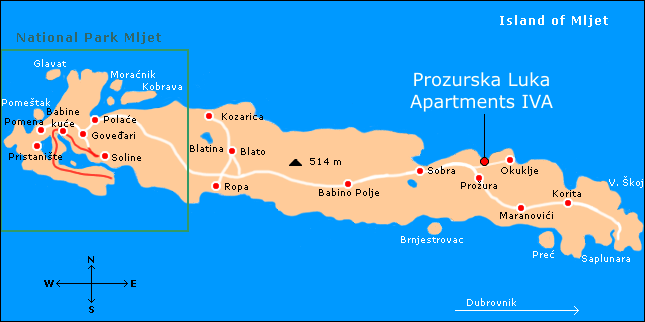
Location: Map
Area: 98.01 km2(38 mi2)
Info: (020) 744 041
Mljet (lat. Melita, tal. Meleda is the eighth largest island in
Croatia, one of the largest South Dalmatian islands and also the
southernmost and easternmost of the larger Croatian islands.
Mljet belongs to the Dubrovnik group of islands and is its
largest island. Just like today, Mljet has gravitated its entire
history exclusively to this area. It is located in the immediate
vicinity of Dubrovnik, Korčula, Elaphite Islands, and is
separated from the Pelješac peninsula by the Mljet channel.
Due to the same name in Roman and later in Latin writings,
Mljet was very often replaced by the island of Malta throughout
history, and today two world-famous legends about the shipwrecks
of Homer's Odyssey and St. Peter's are known. Paul (regardless
of the allegation in acts 27.39-28.11 in which it is
unequivocally said that the shipwreck occurred while they were
sailing the Adria, and regardless of the fact that there were
never venomous snakes on Malta, and they were exterminated on
Mljet by the introduction of mongooses) is attributed to the
larger and world-famous Malta. As a reminder that ancient Ogygia
could also be Mljet, today there are Odysseus ' cave and the
rock of sv. Paul as well as the votive Church in the eastern
part of the island. Equally, regardless of the fact that
Croatian cynologists and veterinary historians believe that the
Maltese originates from Mljet, which is recognized by most
cynological experts who refer to Kalimah Kirenjanin, Pliny The
Elder and Stjepan the Byzantine, and this is more often
attributed to Malta Today.
Mljet is an island of diverse
animal life and original forests of Aleppo pine, Pine pine and
Black Oak. It is considered the most forested and greenest
Croatian island, the western part of which is protected as the
first Adriatic National park, and the eastern part as a reserve
of natural rarities.
There are no larger settlements on
Mljet, mainly due to the poor economic development of the
island, which resulted in permanent emigration of the younger
population. The inhabitants of the island of Mljet are called
Mljecani and Mljecke (the term Mljecanke is often misspelled).
According to the 2001 census 99% of the inhabitants are Croats,
96% of the inhabitants are Catholics and are the only Islanders
(along with the inhabitants of Elaphites) who speak the
shtokavian dialect and ijekavian speech.
Mljet is located in the Dubrovnik archipelago and is its largest island. Its area is 100.4 km2. It is elongated because it is 37 kilometers long and only 3 kilometers wide. It is separated from the Pelješac peninsula by the Mljet Channel. It stretches in the direction northwest - southeast. It is considered the most forested island in the Adriatic, more than 70% of the area is covered by forests, and within the national park the coverage exceeds 90%, which is why it is nicknamed the greenest island in Croatia.
Monastery of Saint Mary is a Benedictine monastery located on an island in the middle of the Veliko Jezero or Great Lake. The islet of Sveta Marija is located in the southern part of Mljet's Great Lake. Its size is 120 m x 200 m. Remains of a Roman building have been found on it, but it is by far the most famous for its 12th-century Benedictine monastery.
Benedictine monks settled here in 1151. The arrival of the Benedictines from Apulia caused dissatisfaction among the local Benedictines (the Benedictine monastery on Lokrum was built in 1203), so the right to the island was given to the Italian Benedictines by the Zahumski prefect Desin (in some sources the Zahumski prince Desa). The Benedictines first built a monastery on the island, and then (at the end of the 12th century) a church. The Romanesque monastery was rebuilt several times. Today's building is a two-storey Renaissance building bordered on two sides by a courtyard, and the main tract, towards the courtyard, has an arcaded corridor. A defensive tower was built on the southeast corner, so all the buildings, including the church, form a defensive unit. The monastery was abandoned in 1869 and the event is associated with the legend that the Benedictines cursed the population of the island by doing everything in reverse order. In the prayer procession they went counterclockwise, and when the candles were lit, they would turn them upside down. Many famous scientists and artists stayed in the monastery as monks. The most famous inhabitants of the Mljet monastery were the Dubrovnik poets Mavro Vetranović and Ignjat Đurđević and one of the most famous Byzantine scholars of his time, Anselmo Banduri. Church of St. St. Mary's within the monastery is a single-nave Romanesque (Apulian) building erected on the model of the one that the Benedictines had in Monte Gargano. The church was rebuilt and expanded in the 16th century, when the coat of arms of Gundulić was placed on the porch.
Both lakes on the Mljet Island were originally freshwater. However a channel was dug to the south shores of the island. This ultimately changed salt concentration of both lakes: Veliko Jezero and Malo Jezero. Human interactions with local fauna did not end here. Mongoose intentionally introduced to Mljet island wiped out all of snake population as well as many of the native species of birds.
The Roman Palace in Polače is the name for the fortification
unit, which consists of an ancient palace, baths, two early
Christian basilicas, an arsenal, a warehouse for galleys and the
remains of piers (today located under the sea), and is located in
Polače, in the bay of the same name. on the island of Mljet.
Throughout the port of Polača, sheltered from strong winds, there
are the remains of columns to which Roman galleys were tied. The
port is protected by four islets (Moračnik, Tajnik, Ovrata,
Kobrava), has a source of drinking water which also determined the
location of the palace. In the 5th century, this Roman estate
provided 500 solidi of annual income. The basis of the economy was
the production of salt, wine, olive oil, honey, meat and cheese of
sheep and goats, dried and salted fish. As traces of the settlement
were not found in the bay of Polača, it is assumed that Roman
galleys spent the winter there and that so many church buildings
were needed. The Palace on Mljet is the third best preserved and
largest Roman monument on the Croatian Adriatic coast, right after
Diocletian's Palace in Split and the Arena in Pula.
The
arrival of the Greeks and Romans on Mljet
The oldest historical
records about the island of Mljet date from the 4th century BC. n.
e. and are tied to Greek sailors who sailed towards their colonies
on the islands of Korcula, Vis and Hvar, and passed through today's
Mljet Channel. Sailing along Mljet, they stayed in places along the
coast where there were sources of drinking water, which undoubtedly
means that they went into the bay of Polače, where they took refuge
during strong south winds because the bay is protected from the wind
on all sides. There are no material remains on the mainland of the
island of Mljet, which would testify to the stay of the Greeks, but
that is why the seabed is rich in amphorae, which undoubtedly proves
their stay. The first concrete data on the settlement of the island
are given by the Roman writer Appian in his work Roman Civil Wars,
describing the wars of Emperor Augustus against the Illyrians on
Mljet and Korčula. Appian states that Augustus then destroyed the
city of Melitus, although historians to this day have not agreed on
where exactly that city would be located. Most historians agree that
it was not actually a city, but a larger Illyrian settlement built
of dry stone walls and that the city is located in the port of
Polače, which has the most suitable conditions for the development
of a larger settlement, because it is deep inland and thus protected
from winds. has a source of drinking water, and the surrounding land
is suitable for the development of livestock and farming.
Creating a settlement in Polače
With the destruction of Melitus,
the Roman emperor Augustus probably occupied only the western part
of the island of Mljet, because he did not have enough soldiers to
comb the whole island, which was then covered with impassable
forests. After capturing the island, an imperial estate was
gradually created in Polače Bay. The Illyrians left Polač for the
east of the island, and over time trade ties were formed between
them and they got to know each other and mixed, which resulted in
the complete Romanization of the Illyrian population. This is
supported by numerous sites where Roman traces were found, for
example in Pomena, where the remains of embers were found, in Ivanje
polje in the middle of the island, as well as in Koriti, where Roman
money was found.
Ancient palace
According to legend, the
palace was built by Agezilaj of Anazarb in Calikia, following the
example of Roman hamlets from the time of the Empire. Agezilaj took
refuge on Mljet together with his son, the poet Opian, after the
Roman emperor, Septimius Severus, expelled him from the court.
Legend further says that the emperor Caracalla freed them from
captivity after the poet composed inspired verses about the beauty
of the sea and fishing in his two didactic epics Kuvnyetika and
Alieutika. Opian and his father refused to return to Rome,
justifying that they would never trade their small empire for a
large one, and in doing so sent the emperor a branch of an Aleppo
pine with a bird's nest in which was a shell. Even today it is not
known exactly when the palace was built, but there is no doubt that
the first estate was built by Augustus, after he captured Mljet.
Over time, a palace was built in which the Roman governor for the
area of Mljet sat. The palace was built to protect its strategic
interests: the bay was safe from the wind, the source of drinking
water was not even fifty meters from the sea. The palace is one of
the most significant monuments of the Roman period, and is one of
the most monumental monuments on our Adriatic coast.
The age of the palace
There are differences among scholars and
historians as to the age of the Roman palace.
F. Bulić
believes that it dates from the 2nd century, based on two fragments
found in the palace.
Š. Karaman, comparing Mljet with the
Diocletian's Palace, classifies the former in the Late Roman phase
and the latter in the Middle Roman Empire, judging by the massive
and unbroken upper part of the Mljet Palace and the openings for
doors and windows, which were drilled on the ground floor. He also
supports his claim with his view of the mosaics in Susa in Africa
from the 2nd century, where matches can be seen in the facade of the
palace and the two octagonal towers.
K. A friend believes that
the palace in Polače was built under the influence of the somewhat
older Diocletian's Palace. The main argument is considered to be the
coincidence of the two palaces in the main lines, so it is believed
that the palace was built in the late third or early 4th century.
E. Dyggve believes that the palace was built in the 5th century, and
he concludes this by the type of construction and by the technique
used to build the palace. Likewise, Dyggve compares the palace at
Polače with the palaces at Ravenna and at Piazza Armerino, which
were built in the 4th and 6th centuries, respectively.
C.
Fisković believes that the palace should be viewed from a wider
spectrum. Cvito Fisković believes that the palace was built during
the invasion of the Avars and Slavs in the area of Ragusa, when
the inhabitants of Ragusa and Narona fled to Mljet. Also, Fisković
believes that the palace was never fully built.
Early
Christian basilicas
The remains of two sacral buildings have been
preserved next to the palace, of which the largest and best
preserved is the early Christian basilica, which is located
southwest of the palace at a distance of about 70 meters. The
basilica was upgraded and expanded three times in separate time
periods. The first layer belongs to the oldest type of early
Christian building in our coastal area, and dates back to the 5th
century. The second layer was built between the 6th and 9th
centuries, while the third layer already belongs to the period of
folk Romanesque from the 12th century. During the excavations,
archeologically valuable material was found in the basilica: a seat
for a priest with a chair for a bishop and a baptistery. A tomb,
completely vaulted inside and a human skeleton, at least 1,500 years
old, was also discovered. Along with the skeleton, many ritual
vessels, an altar marble canteen and the remains of various ceramics
were also found. Also, a stone slab with the following was found.
| PRO SALUTE P. C BALBINIANI TEMPLUM TUUM PORTICO ADAMPLIAVIT MAGNUS LIBERO [ANIMO] [E]T LIBE[N] FECI[T] |
FOR SALVATION (FOR HEALTH) P.C. BALBINIANA TO YOUR TEMPLE IT IS EXTENDED BY THE PORCH SUPREME MANAGER OF THE PROPERTY FREE [WILL] I RADOSTAN BUILT |
Spa
The remains of the baths were discovered in 1980 and are
located about 20 meters from the main wall of the palace. This, an
authentic Roman bath, is located 0.5 meters underground, and in its
immediate vicinity are the remains of a storage room for galleys.
Among the found remains of the bathing place, the most significant
object is the rounded mosaic of the crane bird and it is a symbol of
the Eastern Goths. These baths were luxuriously equipped, and were
located by the sea and the ravine, which, during the rain, flows
abundant water. The wall of these baths is 1.5 meters high and 4
meters long. The swimming pool has not been fully explored because
the mosaic is destroyed very quickly when in contact with air.
Life in the palace
The palace in Polače was of imposing size
and was inhabited by the stewards of this imperial estate, together
with their courtiers and numerous servants, the lower and higher
clergy and the people who lived in the near and far vicinity of the
palace, in small and inconspicuous houses. trace. The ruling class
belonged to the Roman-Romanesque population, and the Romanized
Illyrians served as the main physical force for the extraction and
transfer of stone for the construction of palaces and basilicas. The
culmination of the prosperity of the island of Mljet in the 5th and
6th centuries is proved by the grant of Odoacer from March 18, 489,
by which he donates his coming domesticorum Pierius to the estates
near Syracuse and on Mljet, with the estate on Mljet estimated at
200 solidi per year. at the time it was big money. Such large
incomes were brought by agriculture, developed agriculture,
exploitation of forests, firewood and construction, and trade that
went through the port of Polače, where ships came from all over the
Empire and went to all major ports of the Empire.
Roman
palace in modern history
With the immigration of the first
inhabitants from Babino Polje to Polače, members of the Nodilo and
Dabelić families came across well-preserved parts of the palace
along which they began to build their houses, abundantly using the
proper stones of nearby early Christian basilicas. stop only when
the church is built in the settlement) and the main wall of the
palace. In certain parts of the palace they build magazines for
storing fishing tools and nets, while in other parts they build
stables for domestic animals. Today it is a very interesting
architectural complex. Unfortunately, two culturicides were made to
the palaces in the second half of the 20th century. The first is
related to the breakthrough of the island road and the construction
of the port in Polače, when a good part of the excavations of the
palace were simply covered with asphalt, and the second culturicide
occurred when, due to truck drivers' recklessness, a crane hit the
tower arch and knocked down part of the wall. Soon after, that
damage was repaired. A good part of the palace is still unexplored
today, mainly because the Ministry of Culture of the Republic of
Croatia does not allow any work on the palace, so the Mljet National
Park Administration is practically handcuffed. It is interesting
that during the SFRY there was an idea to move the population of the
old part of Polac to a newer part and to demolish the houses in
order to completely reconstruct the palace in which the museum of
the island of Mljet would be located. A large amount of money was
raised for the project, but the idea was abandoned in 1979, when all
the money for the reconstruction of the palace was diverted to
rebuild Dubrovnik and Kotor, which were badly damaged in the
earthquake. Recently, there has been a tendency for the larger
basilica to be completely reconstructed in order to build a new
church on the foundations of the old one.
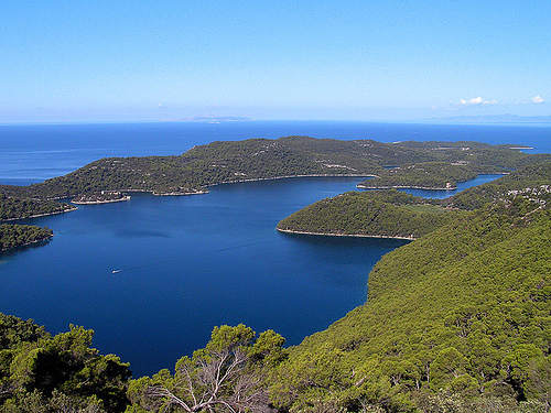
The large lake on the island of Mljet (actually, the bay that is
connected to the open sea near Solin) was created by immersing a
karst field. The Great Lake has an area of 1.45 km², its largest
length is 2.5 km and width is 1 km. The greatest depth of the Great
Lake is 46 meters. The Great Lake connects with the open sea by a
long and wide channel, at a place called the Great Bridge, and from
that place it expands into the Solin Channel and then connects with
the open sea. The Great Bridge before 1960 was shallower and
narrower than it is today, resulting in the creation of a strong sea
current, which changed every six hours. During high tide or low
tide, currents either entered or exited the lake. At this place the
Benedictines built a mill, which was powered by electricity, and was
used for the production of salt (the place of Soline, in the
immediate vicinity, after which it was named). The big bridge was
demolished in 1958 so that the president of the SFRY, Josip Broz
Tito, could enter the lake with his yacht.
On the south side
of the lake is the islet of St. Mary. Its size is 120 m x 200 m.
Remains of a Roman building have been found on it, but it is by far
best known for a Benedictine monastery built when the Benedictines
came to the island in the 12th century. Veliko and Malo jezero are a
natural phenomenon of the Mljet National Park and also the most
visited place on Mljet.
The small lake is located on the island of Mljet, northwest of the Great Lake and is connected to it by a canal 30 meters long and up to 0.5 meters deep, through which also, depending on the tides, a strong sea current flows. The canal is located in a place called the Little Bridge. The surface of the lake is 0.25 km2, and its greatest depth is 29 meters. The sea in Little Lake alternates little, so it has the property of a lagoon. Veliko and Malo jezero are a natural phenomenon of the Mljet National Park and also the most visited place on Mljet.
Sandy beaches and wild pine forests in the area of Saplunara
Remains of the Church of St. Paul from early Christian days.
The
cliff of St. Paul
Tower for the supervision of navigation through
the Mljet Channel in Korita and in Prožura
Rector's Palace in
Babino Polje
Church of St. Blaise in Babino Polje
Monument to
fallen fighters from the National Liberation War in Babino Polje
Odysseus Cave
Blatine, small lakes with brackish water in
Prožura, Sobra, Blato and Kozarica
Early Christian basilicas and
the remains of a spa with a mosaic of cranes in the settlement of
Polače
The remains of an Illyrian fort on a hill above the Great
Lake
A monument to the first landing on the southern Adriatic in
World War II, on the Great Lakes
Geomorphological site Zakamenica
Mljet is located within an isobath of 100 meters, which
shows that it was once an integral part of the neighboring mainland,
as well as all Croatian islands. The relief of the island has a
fragmented and very dynamic appearance. The highest peak of the
island is Veliki grad (514 m), while at the same time many peaks
exceed 300 meters. Along the island there are many karst valleys
(fields) and about a hundred smaller valleys. There are several
islets and reefs around Mljet.
The lithological composition
of Mljet is quite simple. The island hull is built of limestone and
dolomite of Mesozoic age. Some experts claim that there are areas
with volcanic rocks on Mljet. The geologically oldest parts of the
island, the Upper Jurassic deposits, are located in a relatively
narrow zone in the central part of the southern coast. Slopes with a
slope greater than 55 degrees, steep, located on the southwest coast
of the island. They are almost vertical and exposed to the open sea
and large waves that shape them with abrasive action. Steep slopes
are most often indicators of the deep sea right next to the shore,
so some steep slopes end only at a depth of 80 m. At the bottom of
the Little Lake there are two deep pits that extend to a depth of 38
and 50 m. As a typical karst island, Mljet is rich in caves and
pits, of which the 77 m deep pit on Brekalci stands out. In the
Jarač pit on the pontoon of Graz near Polač, there are rare
travertine stalactites, characterized by the fact that they grow by
calcifying the plants that live on them. These stalactites were
first recorded in Croatia in 2007 in the Galičnjak cave in the
southeastern part of the island. In addition to land, there are
numerous sea caves and pits.
The coast of Mljet is very
indented, while the northwestern shores (Veliko and Malo jezero, the
bays of Lastovska and Pomena and the bay of Polače) and the
southeastern coast (Saplunara) stand out.
Mljet belongs to the Mediterranean climate area, so the summers are dry and long, while the winters are rainy and mild. The spring-summer period is most often marked by dry, warm, sunny and clear weather, while rain falls only in case of storms or strong south wind. In the summer months, the most common wind is the mistral. Autumn-winter weather is quite fresh because a strong bora can blow. Rains are frequent due to exposure to southerly winds. Temperatures rarely drop below zero, and snow typically falls once a decade.
The islands of the Adriatic Sea, due to their natural position,
have always gravitated to the Mediterranean, but also to the
immediate Dinaric hinterland, where the first inhabitants of Mljet
came from.
Illyrian population on Mljet
The first
inhabitants of Mljet were the Illyrians from the Ardije tribe, who
came to Mljet 4000 years ago via the port of Prapratno on the
Pelješac peninsula. They had their first contact with Mljet in the
ports of Sobra and Okuklje, because they were closest to Pelješac,
but they also came into contact with the ports of Polače and
Kozarica. Arriving on a completely forested island, they slowly
settled along the sources of drinking water and along the edges of
the island valleys. They lived in small dwellings built of dry stone
walls, while they were covered with branches of macchia and pine.
They were engaged in animal husbandry, mainly goat and sheep
breeding, hunting and fishing. They gradually cleared the forests,
which was primarily the job of the male population, while the female
population planted grain in the cleared areas. They lived in smaller
and larger tribes, who did not communicate with each other because
they were overly hostile. Proof of this are the numerous remains of
the so-called forts, which served to defend against an enemy tribe
or to defend against a common non-German enemy. The forts have never
been found near the sea, but are all, without exception, on
medium-high and easily defensible hills. The method of construction
and selection of sites is almost identical for all found forts. On
the one hand, there is an impassable natural barrier, and on the
other hand, they built walls of several layers of stone, so that
during the conflict, more than 100 people could take refuge in the
forts. At the site of the hillfort there was always a good view of
the surroundings, most often of the surrounding hills, fields and
the sea. Many forts were facing the Mljet Channel. The Illyrian
population was more densely populated in the middle of the island
and in the western part (in this area most remains of forts and
graves were found, while in the eastern part there are much fewer.
The arrival of the Greeks and Romans on Mljet
The first historical records about the island of Mljet are
related to Greek sailors, who, sailing towards their colonies on
Korčula, Vis and Hvar, safely passed through the Mljet channel and
took refuge in the Mljet bays during strong southern winds. Except
during inclement weather, the Greeks took refuge in the bays of
Sobra and Polača due to sources of drinking water, which were near
the sea coast. There is no material evidence of the Greeks living on
Mljet, so it can be concluded that the Greeks did not even inhabit
Mljet, but used it for rest and as a shelter from bad weather. Proof
of this are the underwater sites of Greek amphorae in today's ports
of Okuklje, Sobra and Polača, which were created in the middle of
shipwrecks in bad weather or during pirate attacks by the local
population. Mljet came under Roman rule in 167 BC. when the Ardian
ruler of Gentia went to war against Rome and was defeated in that
war. At that time, the Romans conquered the area up to present-day
Albania. Roman rule on Mljet was nominal because the Illyrians
continued to pirate through the Mljet Channel. The first concrete
information about Mljet can be found in the Roman writer Appian, who
described the wars of Emperor Augustus with the local population on
Mljet. Appian in his work De rebus Illyricis states that Augustus
destroyed the Illyrian city of Melitus in 35 BC. due to frequent
pirate attacks on Roman ships. By subjugating the local population,
the Romans in the Gulf of Polača, during the 3rd century, began to
build an imposing palace in which the Roman governor of this estate
sat. The palace also had a defensive function, as evidenced by two
strong towers at its ends. Along with the palace, over time, two
early Christian basilicas and baths were built, which indicates that
in the palace, in addition to the governor, lived the clergy and,
which indicates that Polače at that time lived and functioned as a
late antique or early medieval city. By creating ties, primarily
trade, with the Illyrians, the Romans gradually completely Romanized
the local population, who did manual labor for the needs of the
Roman population. The remains of the piers in the seabed of Polače
indicate that Polače was already a trading port from which the ships
exported wood for construction and firewood, and imported everything
that was needed on Mljet at that time.
Mljet under the rule
of Neretva Pagania
After the division of
the Roman Empire into East and West, Mljet belonged to the
Western Roman Empire and remained part of it until its final
fall, after which, in 493, it fell under the rule of the Eastern
Goths. After Justinian's campaign in 535 against the Eastern
Goths, Mljet, together with the whole of Dalmatia, belonged to
the Eastern Roman Empire. Throughout all this time, Mljet
remained inhabited, especially its western part, primarily
thanks to the Roman palace in Polače, which still provided the
possibility of good living and safe shelter. With the
immigration of Slavs to Dalmatia, the Romanesque Christian
population found themselves on Mljet, as evidenced by the
basilicas in the immediate vicinity of the palace in Polače. The
arrival of Slavs and Avars in these areas brings a historical
turning point mainly because they destroyed all Roman city
strongholds and thus officially ends the Roman rule, which
lasted more than 800 years in this area. At that time, the
entire Roman population fled from the mainland to the islands,
so Mljet received emigrants from Narona, Ragusium and smaller
Roman towns from Pelješac and Korčula. According to Constantine
Porphyrogenitus, at that time the Sclavinia were formed, which
were called: Duklja, Travunija, Paganija (the area from the
Cetina to the Neretva), Croatia and Serbia. Mljet fell under the
rule of Neretva Pagania during the 7th and 8th centuries. With
the coming to power of Michael II. Stuttering, the power in
Byzantium begins to weaken, which the Neretvans use to settle
Mljet. Emperor K. Porphyrogenitus, in his work De administrando
imperio, wrote that Mljet, Korčula, Hvar and Brač are under the
rule of the Neretvans, who live there, keep cattle and live from
it. The Neretvans come to Mljet via Pelješac, just like the
Illyrians, and build their settlement (the first Slavic
settlement on Mljet) above the present-day settlement of
Maranovići and call it Vrhmljeće (later it will descend to
Okuklje, which until then served as a fishing port, which will
result in the complete extinction of the old queen in Vrhmljeć).
They are engaged in farming and animal husbandry, and in slow
migrations they inhabit a large fertile field in the middle of
the island. Babino Polje, the second Slavic town on the island,
would later emerge from this settlement, while Blato, also
inhabited due to its extremely fertile soil, would become the
third. The fourth place will be Žare, in the far east of the
island, from which the population will later move to the
settlement of Korita, completely invisible from the sea and
therefore very safe for life. The Slavs inhabited the eastern
part of the island, where the influence of the Roman population
from Polač weakened, which held the area up to Crna Klada (the
area of today's Mljet National Park) and which held power in
the western part of the island until the 11th century, slowing
down Slavic settlement. The Roman population clashed with the
Neretvans at the end of the 10th century. The Neretvans won the
battle, which resulted in the complete emigration of the
non-Slavic population. Polače, as a continuously inhabited area
since the 1st century, is slowly dying out and a new settlement
will not spring up in that area for a full seven centuries.
The rule of Zahumlje, Duklja and Raška
Shortly after the
victory in the fight against the Roman population and the
expulsion of the same from the island, the Neretva region fell
apart. Part of its territory belonged to the medieval state of
Croatia, while the islands of Korčula and Mljet belonged to
Zahumlje, which was ruled by Prince Ljutovit and will remain in
his possession until the middle of the 12th century. During his
reign, Ljutovit donated to the Benedictine abbot Peter the
church of St. Pankracija in Babino Polje and threatened all the
inhabitants of the island and its surroundings that they must
not in any way disturb or interfere with the Benedictines in
their possession of the church and the land. At that time,
Ljutovit enjoyed the support of the Byzantine government, but
when the Serbian prince Vojislav defeated the Byzantine army, he
automatically defeated Ljutovit as well. Zahumlje lost the
independence it had during the Byzantine period and, together
with Mljet, fell under Duklja. Mljet remained under Duklja
during the time of Vojislav's successor Mihajlo (1050 - 1082),
as evidenced by the votive church of St. Mihajlo in today's
Sutmiholjska bay, where a pre-Romanesque plait was found.
Travunija and Raška then came under the rule of Duklja, and with
the coming to power of the Raska prince Desa, Mljet came under
the rule of Raška. During this period, significant events took
place on Mljet that will significantly affect its further
cultural and economic history.
Benedictine rule on Mljet
The Benedictine monastery on Lokrum, in the middle of the 11th
century, took under its rule the Benedictine estate which Prince
Ljutovit gave to Abbot Peter in permanent ownership. The Lokrum
Benedictines owned this estate for 200 years and it was considered
to be the most valuable estate on the island because of the very
fertile and arable land it owned. Due to the contributions that the
Lokrum Benedictines received from Mljet, they did not want to give
up that property, which caused problems when three Benedictines of
the Pulse order from Apulia came to the island. The Benedictines
Marin, Šimun and Vilim came to the island from Monte Gargano in
Italy and had their first contact with Mljet in the bay of
Sutmiholjska where the Benedictines had their property. Since no
remains of any priestly court were ever found, it is assumed that
immediately upon arrival they began to look for a place to live and
found it on a small island in a lake in the western part of the
island. This part of the island was ideal for the Benedictines
because the area was almost uninhabited, and sources of drinking
water and fertile fields were at their fingertips. In the conflict
over the property in Babino Polje, they emerged victorious because
they got the property. The church was built in a very short time
because Pope Innocent III. in his bull of 1198 he also mentions the
monastery of St. Mary as his possession. In a very short time, they
built a monastery next to the church, and with the document of the
Serbian king Stefan the First-Crowned, the estates in Babino Polje
became the property of the monastery of St. Marija, and at the same
time the monastery became the vassal lord of the whole of Mljet, and
in a very short time they established their feudal rule on the whole
island. The Benedictines produced all the food themselves with their
own work, and they showed the local population how to grow a
particular crop, which greatly improved agriculture on the island.
Except for the economy, the Benedictines played a major role in the
development of literacy. It is believed that the library of the
monastery on Mljet belonged to the ten largest Benedictine abbeys in
all of Dalmatia. Over time, the Benedictines became both
ecclesiastical and civil authority on the island. By a special
document issued in Dubrovnik on September 24, 1345, the monastery
freed all the islanders from all contributions and services to the
abbey, but with an annual income of 300 perpers and one hen per
family. The strength and importance of the Mljet monastery is also
shown by the fact that all Benedictine monasteries in Dalmatia,
except the one on Lokrum, were subject to the monastery on Mljet.
Dubrovnik government on Mljet
After the adoption of the Mljet
Statute in 1345 and after the liberation of the islanders from
serfdom, the people of Dubrovnik slowly began to prepare to
establish their rule on Mljet as soon as possible. Diplomatically,
using numerous tricks, they managed to rebel the local population
against the abbey and help them get rid of its feudal lordship.
During that struggle, the Venetians received rich help from
Dubrovnik, but when they realized that they were gaining only
apparent freedom and that their power was being tightened more and
more, it was too late for any resistance. The revolt raised by the
people of Mljet was quickly quelled, and then Dubrovnik extended its
power to Mljet. On September 9, 1410, the Grand Council passed a
conclusion on the subordination of the island of Mljet to the prince
of Šipan and Otok, and on November 15, 1410, the Grand Council
passed regulations on Mljet, making Mljet definitely part of the
Dubrovnik Republic. Mljet will remain under Dubrovnik until the
abolition of the Republic in 1808.
Mljet in the 20th century
With the abolition of the Republic of Dubrovnik, Mljet became part
of the Illyrian provinces, and later Mljet was ruled by Austria.
After the First World War, Mljet was part of the State of SHS, the
Kingdom of SHS and the Kingdom of Yugoslavia (Banovina of Croatia).
During the Second World War, Mljet was occupied by Germans and
Italians. The population gladly accepts the newly established
Independent State of Croatia, but is immediately disappointed
because Mljet, on May 14, 1941, was handed over to fascist Italy
together with a large part of Dalmatia. Thus, for the first time in
history, it was physically separated from its natural environment
(hinterland), because Dubrovnik and Pelješac remained part of the
NDH. The gradual Italianization of the population begins. Italian
teachers are brought to the island, and the children learn Italian
instead of Croatian. The first partisan detachments began to be
formed, and on April 21, 1944, the first naval landing on Mljet was
carried out. The war on the island ended with the withdrawal of
German forces on 10/11. August 1944.. Mljet is again part of
Croatia, initially as the Federal State of Croatia (within the
Democratic Federal Yugoslavia), later the People's Republic of
Croatia (FPRY) and the Socialist Republic of Croatia (SFRY). Since
October 8, 1991, based on the expressed desire of the Croatian
people in the referendum on the independence of Croatia, Mljet has
been part of the democratic, independent and sovereign state of
Croatia.
Mljet is rich in vegetation, and over 70% of the
island's surface is covered with forest, which is divided into two
large groups: the Aleppo pine forest and the evergreen deciduous oak
forest. In addition to these two types of forest, there are also
maquis, garig and rocky. Aleppo pine forests, especially rich in the
area of NP Mljet, form the best-preserved and most beautiful type
of forest of its kind in the Mediterranean, as well as holm oak
forests. The only larger indigenous holm oak forest in the Adriatic
is located on the island of Rab (Dundo forest). In the area of
Saplunara, in the east of the island, there is a wild forest of
tame pine, pine. This part of the island is protected as a reserve
of natural rarities. Today, the known flora of lichens on the island
consists of a total of 161 species, and the most suitable habitats
are old olive groves and unburned holm oak forests. There are
significant finds from the genus Usnea, especially Usnea rubicunda,
for which the island of Mljet is currently the only site in Croatia.
Lobarion pulmonariae lichens have also been reported, which are very
sensitive to microclimate change and pollution and can serve as an
excellent indicator of air quality. Of the 133 species of fungi
recorded in the park, ten species are on the Croatian Red List of
Endangered Fungi. Entoloma reinwaldii, Clitocybe collina, Dermoloma
cuneifolium and Dermoloma josserandii stand out.
Of the
animal species on Mljet, the most common are the marten, mouse,
down, hedgehog, frog, common chanterelle, small grasshoppers,
numerous birds (blackbird, wild pigeon, common sparrow, great
bustard, seagull, falcon and others) and white-tailed deer and
blind. Until the First World War, there were also venomous snakes on
Mljet, but in 1910 the Austrian forestry brought several pairs of
Indian small mongooses to Mljet, and venomous snakes were completely
exterminated from the island. In addition to mongooses, deer,
mouflon, wild boar, rabbits, partridges and pheasants were also
brought to Mljet. Only deer and wild boar managed to breed in large
enough numbers.
The underground fauna is extremely rich, with
about fifty species of invertebrates, of which about twenty are
endemic. Among the recorded are insects beetles, snails, spiders,
lizards, jumpers, isopods and corncrakes. Several species are
novelties for Mljet, Croatia and even science. The island endemic
insect beetles Gobanc's underground (Speonesiotes gobanzi) and
Krile's crumb (Bryaxis krilei), the first representative of this
genus on Mljet; snail Mljet cave dog (Meledella werneri); crabs
Mljet thistle (Cyphodilidium absoloni) and Gamulin's cave oarsman
(Speleohvarella gamulini).
Along the coast there are rich
hunting grounds for blue and white fish, and the seabed is rich in
lobsters, crabs and vapors. Various corals live at greater depths,
the most famous of which are red and stone coral. Along the outer,
southern shores of Mljet, it used to be a habitat for the
Mediterranean seal. The park is home to about thirty pairs of sea
crows that feed exclusively on fish, diving to a depth of 60 m. At a
level below 30 m depth, the sea temperature averages less than 11
degrees Celsius throughout the year, which is not conditioned by the
surrounding sea because there is only a slight vertical mixing of
the layers. Constantly elevated values of nutrient salts,
chlorophyll, phytoplankton and zooplankton species were found in the
layer. A similar phenomenon is recorded only in the deep furrows of
the Mediterranean Sea. This is an area of strong sea currents and
the occurrence of rising cold sea layers rich in nutrients from the
depths to the surface. This benefits coralligenous communities, so
there is the esteemed red coral (Corallium rubrum) as well as about
sixty other species of coral. As they are sensitive to temperature
changes that occur more frequently, last longer and affect deeper
layers of the sea, tissue death and coral death occur.
There are three large springs of brackish water (blatina) near Blato, Sobra and Prožura, which serve to irrigate the fields and as a source of drinking water in the summer months because Mljet is not yet connected to the state water supply. Large eel hatcheries are formed in the mud in winter. Apart from mud, there are smaller sources of drinking water, the largest of which are in Polače, in Oman near Sobra and in Vodice near Polače and near Babino Polje.
Due to the relatively small number of inhabitants,
but also due to its elongated and narrow appearance, Mljet does not
have an extensive network of roads. There are no daily bus lines,
except for one return line to Dubrovnik and one return school line.
In the summer months, bus lines are not intensified, but are
reimbursed by private taxi services.
Mljet, on the other
hand, is very well connected to the mainland. There are daily lines
from Sobra to Dubrovnik and to Prapratno on Peljesac. In the summer
months, Mljet is connected by ferry and high-speed ferry to
Pelješac, Dubrovnik, Šipan, Korčula, Split and Bari in Italy via the
port of Sobra, while it is connected to Dubrovnik, Korčula and
Lastovo via the port of Polače.
A heliport is under
construction, just as there are some indications that an airport for
smaller aircraft could also be built.