Location: French Alps Map
Height: 12,316 ft (3,754 m)
Ofice du tourisme
Chamonix
Tel. 50 53 22 08
Weather conditions:
Tel. 50 53 03 40
winter 50 53 17 11
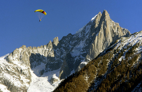
Les Drus (Aiguilles du Dru) is one of the most iconic and striking
granite peaks in the Mont Blanc massif, towering dramatically above
the Chamonix Valley in France. Located east of Les Praz, the twin
summits—Petit Dru (around 3,733m) and Grand Dru (3,754m)—feature
sheer vertical faces, particularly the legendary North and West
Faces, making them a symbol of alpine climbing heritage.
The
mountain is renowned for its technical granite climbing, exposed
ridges, and historical significance (first ascents in the late
1870s, with major routes like the North Face in 1935 by Pierre
Allain). It offers breathtaking views over the Mer de Glace glacier
and surrounding peaks like Aiguille Verte.
Visiting Les Drus
ranges from scenic viewpoints for casual hikers to serious multi-day
alpine climbs for experts. Here’s an in-depth guide with practical
tips.
1. Best Time to Visit
Summer (June–September): Prime season for
climbing and high-alpine access. July and August are ideal for drier
rock and stable weather, though rockfall risk increases in hot
conditions.
Avoid shoulder seasons if inexperienced, as snow/ice can
glaze rocks and increase avalanche/rockfall hazards.
Check conditions
daily: Rockfall is a notable risk on faces like the North Face
(especially the “Niche” hanging icefield). Cold nights help stabilize
things.
Weather: Mountain weather changes rapidly. Use reliable
forecasts (e.g., MeteoBlue or local hut guardians). Thunderstorms are
common in the afternoon.
2. How to Get There (Base: Chamonix)
Chamonix serves as the main hub (easy access from Geneva Airport via
shuttle ~1 hour).
For Viewpoints (Non-Climbers): Take the Montenvers
train (from Chamonix) to admire Les Drus towering over the Mer de Glace.
Hikes from there or cable cars (e.g., Grands Montets area) offer
excellent panoramas without technical terrain.
For Climbs/Huts:
Montenvers train → descend to Mer de Glace glacier → cross and ascend to
Charpoua hut (main base for south-side routes).
Approach to
Charpoua Hut (2,841m):
Train to Montenvers (~1,913m).
Ladders and
glacier crossing, then a steep 3–4+ hour hike with fixed cables in
places (exposed, requires no vertigo and basic mountaineering
experience).
Alternative approaches from Grands Montets for
north/west faces (more demanding).
Tip: Book the Montenvers train in
advance during peak season. Carry crampons/ice axe for glacier travel
early or late season.
3. Accommodations
Refuge de la Charpoua:
The classic base camp at the foot of Les Drus. Small (oldest and tiniest
in the valley, ~14 bunks), historic, and atmospheric. Renovated in
recent years. Half-board, B&B, or bed-only options. Silk liner/sleeping
bag liner mandatory. Bring your own water (limited supply).
Book well
in advance via their website or phone. Mandatory reservation.
Bivouac: Common for north/west face routes (no hut access). Plan for
high-alpine camping.
Chamonix Valley: Hotels, campsites (e.g., Les
Praz or Les Bossons), gîtes for before/after. Many options for all
budgets.
4. Main Activities and Routes
For Casual
Visitors/Hikers:
View from Montenvers or balcony trails in the
valley.
Longer hikes in the area for panoramic views (e.g., towards
Aiguille Verte).
For Climbers (Experienced Only):
Traverse des
Drus (Normal Route / Voie Classique): The most reasonable “easiest” way
up. Involves south face, ridge traverse (Petit to Grand Dru), and
abseils down. Rated ~D+ (difficult), with 5c/6a pitches in boots +
backpack. Often 12+ hours from hut; multi-day guided trips common.
Requires excellent rope skills, abseiling proficiency, glacier travel,
and high fitness.
North Face Routes: Legendary and committing (e.g.,
Pierre Allain route). Much harder, with rockfall risks.
Other
Classics: American Direct, Bonatti Pillar (partially affected by
rockfall), Voie des Guides, etc.
Guided Trips: Highly recommended
for first-timers. Companies like Chamex offer 3-day packages (~€3,190
for 1:1 guiding).
Equipment: Helmet, harness, crampons, ice axe,
double ropes, rock rack, mountaineering boots, warm layers, headlamp,
etc. Acclimatization is essential.
5. Safety and Essential Tips
Technical Difficulty: Not for beginners. Strong rock climbing (granite),
exposure, route-finding, and descent skills needed. Many sections have
loose rock.
Rockfall & Objective Hazards: Significant risk,
especially in warm weather. Start very early (e.g., 1 AM from hut).
Monitor for changing conditions.
Physical Demands: Long days (12–26+
hours for traverses), elevation, carrying packs. Excellent stamina
required.
Rescue: Expensive in France. Have insurance (e.g., via UIAA
or specialized alpine policies). Carry a phone (limited signal—consider
satellite device).
Leave No Trace: Respect the fragile high-alpine
environment. Follow hut rules strictly.
Acclimatization: Spend time
at altitude first (e.g., other Chamonix peaks).
Partners/Guides: Solo
only if highly experienced. Conditions can deteriorate fast.
Emergency: Know the local mountain rescue number (e.g., 112 in Europe,
or specific Chamonix services).
6. Additional Tips
Permits/Regulations: No special permits usually, but hut bookings are
essential. Check for route closures due to rockfall.
Sustainability:
The Alps face climate impacts (glacier retreat, rockfall). Be mindful.
Cultural Note: The area has a rich climbing history—read up on legends
like Walter Bonatti or modern ascents for inspiration.
Combine with
Other Activities: Pair with Mer de Glace visit, Aiguille du Midi cable
car, or easier hikes.
Budget: Expect high costs for guides, huts
(~€50–100/night half-board), and transport. Plan for weather days.
Location: East of the Aiguille Verte on its west ridge, entirely in
French territory in the Chamonix Valley.
Rock: High-quality granite,
though the mountain is notorious for instability and rockfall (major
events in 1997, 2005, 2011, etc., especially on the West Face).
Terrain: Predominantly rock climbing with some mixed/ice elements
possible. Even "easier" routes are long, sustained, alpine-style
endeavors with complex route-finding, loose sections, and serious
descents.
Reputation: A testpiece for experienced alpinists. Routes
demand strong rock skills (crack climbing, chimneys), altitude
tolerance, and risk management. No truly easy way up or down.
Climbing History Highlights
First Ascent Grand Dru: 12 September 1878
by Clinton Thomas Dent, James Walker Hartley, with guides Alexander
Burgener and K. Maurer (southeast face). Dent praised its continuous
interesting rock climbing.
First Ascent Petit Dru: 29 August 1879 by
J. E. Charlet-Straton, P. Payot, and F. Folliguet (south face/southwest
ridge).
First Traverse (Petit to Grand Dru): 1901 by E. Fontaine and
J. Ravanel.
North Face Milestone: 1935 by Pierre Allain and Raymond
Leininger (Allain-Leininger route) — a landmark in big-wall alpinism.
West Face & Bonatti Pillar: Walter Bonatti's legendary 6-day solo ascent
in 1955 on the southwest pillar (now largely destroyed by rockfall).
American teams (Hemming/Robbins) added direct routes in the 1960s.
Modern/Extreme: Free solos (e.g., Christophe Profit on American Direct),
winter ascents, and new mixed lines like BASE (M8+, 2021 by GMHM team).
The peak remains a venue for cutting-edge climbs.
A Madonna statue
was placed on the summit in 1919 and remains a landmark.
Major
Ascents and Routes
Routes vary from classic traverses to extreme
big-wall lines. Difficulties use the French alpine grading system (e.g.,
AD = assez difficile, D = difficile, TD = très difficile, ED =
extrêmement difficile).
1. Traverse of the Drus (Traversee des Drus /
Petit Dru to Grand Dru)
Difficulty: D to D+ overall (max ~5c/6a rock,
some A0).
Length: Long day or multi-day (e.g., 10+ hours; guided
trips often 3 days).
Description: The "easiest" and most classic way
to experience the peaks. Involves complex ridge terrain, gendarmes,
scrambling, and technical passages. Starts via Flammes de Pierre ridge
approach. Highly committing with sustained interest and exposure. Often
combined with extensions toward Aiguille Verte.
Why popular: Iconic,
varied, tests route-finding and endurance. Still serious—no pushover.
2. Petit Dru Normal Route (South Face)
Difficulty: D- (IV, with a
5c move), ~400 m.
First Ascent: 1879.
Approach: Via Charpoua Hut
(from Montenvers, cross Mer de Glace, ~3-4 hours to hut).
3.
North Face Routes (Petit Dru)
Allain-Leininger (Classic North Face):
TD+, 5c, ~850-1,000 m. Steep cracks, grooves, chimneys; mixed near top.
One of the six great north faces. Winter ascents add significant
challenge.
Other notable: Polish Route ("Petit Jean"), Northeast
Couloir (ice to 80°).
4. West/Southwest Face Routes
Bonatti
Pillar: Historic ED+ solo (now largely gone due to 2005 rockfall).
American Direct: ED-, 6c (6b obbl.), ~1,000 m (link-ups with North Face
possible). Sustained, athletic crack climbing.
American Direttissima:
Even harder (destroyed in rockfalls).
Modern: BASE route (mixed, high
difficulty) follows similar lines.
Note: West Face is highly
unstable—major rockfall risk. Check conditions carefully.
5.
Other South Face Routes (Grand Dru)
Normal Route: AD.
Voie
Contamine: TD, 6a+, 650 m (excellent rock).
Pilier du Trident, etc.:
TD to TD+.
Many routes involve 20-35+ pitches, with alpine
commitment.
Approach and Logistics
Primary Access: Montenvers
train station (from Chamonix). Cross Mer de Glace (ladders/fixed ropes
due to glacial retreat).
South routes → Charpoua Hut (small,
reservations needed).
North/West → Bivouac at Rognon du Dru or
similar (no hut).
Alternative: Grands Montets area (more arduous
now).
Time: Approaches take 2-5 hours depending on side; full climbs
often require bivouacs.
Best Season: Summer (dry rock), but
rockfall increases with warmth. Winter/spring for mixed/ice lines
(colder, more stable but harder). Always monitor weather and conditions.
Gear: Standard alpine rock rack (cams, nuts, slings), crampons/ice axe
for approaches/glaciers, bivy gear for longer routes.
Challenges
and Considerations
Rockfall Hazard: Significant, especially West
Face. Melting permafrost exacerbates this.
Commitment: Long routes,
difficult retreat, complex descent (often rappels + downclimbing).
Physical/Technical Demands: Strong crack climbing, route-finding,
endurance at altitude.
Objective Dangers: Weather changes rapidly;
stonefall common.
Current State: Some classic lines
altered/destroyed. New routes continue to be established.
Location and Setting
Coordinates: Approximately 45°55′58″N
6°57′23″E.
It rises dramatically east of the village of Les Praz
in the Chamonix Valley, on the northern side of the Mont Blanc
massif in the Graian Alps.
It sits on the western ridge of the
higher Aiguille Verte (4,122 m / 13,524 ft), separated by a deep
notch and a long connecting ridge.
The peaks tower above the
Charpoua Glacier and are visible from much of the Chamonix valley,
including iconic viewpoints like the Montenvers train station
overlooking the Mer de Glace (Sea of Ice).
The mountain is
renowned for its striking, needle-like profile ( "Aiguille" means
"needle" in French), making it one of the most photogenic and
recognizable features in the Alps.
Topography and Structure
Les Drus consists of two distinct summits connected by the Brèche du
Dru (a col/saddle at 3,697 m / 12,129 ft):
Grand Dru (Grande
Aiguille du Dru): 3,754 m (12,316 ft) — the higher main summit.
Petit Dru (Petite Aiguille du Dru): 3,733 m (12,247 ft) — the
slightly lower neighbor.
From a distance, it appears as a
colossal rocky pyramid or monolith, but it is composed of these two
nearby peaks. The structure features extremely steep, vertical
granite walls, including:
A west face nearly 1,000 meters (3,280
ft) high — one of the steepest and most impressive in the Alps.
A
legendary north face (particularly of the Petit Dru), counted among
the six great north faces of the Alps.
The terrain is
characterized by jagged ridges, sharp spires, exposed granite slabs,
couloirs, and significant vertical relief. It drops sharply toward
the Chamonix Valley and surrounding glaciers.
Geology
Les
Drus is formed almost entirely of Mont Blanc granite (a
coarse-grained calc-alkaline granite). This rock dates back to the
Hercynian orogeny (~305 million years ago).
The granite is known
for its quality but also its tendency to fracture, leading to
periodic major rockfalls (notably in 2005, which destroyed classic
routes like the Bonatti Pillar on the southwest face).
The rock
is protogine (a variety typical of the Mont Blanc area),
contributing to the light-colored, fractured appearance and the
dramatic, sheer cliffs.
This geology creates excellent (though
sometimes loose) climbing rock but also makes the mountain dynamic
and subject to ongoing erosion and instability.
Glaciers and
Surrounding Features
The peaks rise directly above the Charpoua
Glacier (to the south/west).
Nearby are other major glaciers like
the Mer de Glace and Glacier du Talefre.
The surrounding
landscape includes high-alpine meadows, moraines, extensive
snowfields (especially in winter/spring), and the broader Mont Blanc
range with its mix of granite spires, icefields, and deep valleys.
Significance and Human Context
Geographically, Les Drus
serves as a dramatic sentinel overlooking the Chamonix Valley, one
of the world's premier mountaineering and tourism hubs. Its position
on the western ridge of Aiguille Verte makes it a key feature in the
complex ridge systems of the Mont Blanc massif.
It is a
world-famous destination for technical alpinism, with routes ranging
from the "easiest" (still AD difficulty) to extreme big-wall style
climbs on its vast faces. The mountain's imposing presence has
played a major role in the history of modern mountaineering.
In
summary, Les Drus exemplifies the raw power and beauty of the French
Alps: a towering granite fortress with razor-sharp profiles, immense
vertical walls, and a location that offers unparalleled views of the
Mont Blanc region while posing serious challenges due to its
steepness, rock quality, and exposure.