Location: Provence-Alpes-Côte d'Azur Map
Area: 264 sq mi (685 sq km)
Highest point: 10,309 ft (3,143 m)
Tel. +334 9281 2131
Official site
Mercantour National Park (Parc national du Mercantour) stands as a remarkable wilderness preserve in southeastern France, celebrated for its stunning high-alpine scenery, extraordinary ecological diversity, and close proximity to the azure waters of the Mediterranean. Founded on August 18, 1979, as France's sixth national park, it covers a core area of 679 square kilometers (262 square miles), expanding to a total of 1,801 square kilometers (695 square miles) when including its peripheral zones. This protected expanse, one of 11 national parks in France, safeguards vulnerable habitats and cultural treasures while facilitating responsible tourism. Its "twinned" status with Italy's adjacent Parco Naturale Alpi Marittime, established in 1987, creates a seamless transboundary conservation area honored by the Council of Europe for fostering international collaboration in environmental protection. Often called the "last wild land" in the Alps, Mercantour offers a dramatic escape from the bustling French Riviera, blending untamed mountain grandeur with subtle Mediterranean influences.
Mercantour National Park (Parc national du Mercantour) is a vast
protected area in the French Alps, covering about 685 square kilometers
across the Alpes-Maritimes and Alpes-de-Haute-Provence departments in
southeastern France. Bordering Italy's Alpi Marittime Natural Park, it's
renowned for its rugged mountains, glacial lakes, diverse wildlife
(including wolves and ibex), and over 600 km of hiking trails.
Established in 1979, it's a UNESCO Biosphere Reserve with altitudes
ranging from 500 to 3,143 meters (Mont Ténibre). Access depends on your
starting point and desired sector—key valleys include Vésubie, Tinée,
Roya, and Ubaye. Major entry towns are Saint-Martin-Vésubie (Vésubie
Valley), Tende (Roya Valley), Barcelonnette (northern Ubaye), and
Valdeblore (Tinée). The park is car-friendly but has public transport
options, especially from Nice, about 1-2 hours away.
By Car
Driving is the most convenient way to reach and explore the park, given
its rural, mountainous terrain and limited public transport within. Rent
a car at Nice airport or city center for flexibility. Key routes:
From Nice (southern access): Take the A8 autoroute east, then exit
to RM2205 or D2205 toward valleys like Vésubie (to Saint-Martin-Vésubie,
~1 hour) or Tinée (to Valdeblore or Saint-Étienne-de-Tinée, ~1.5 hours).
For Roya Valley, continue on D6204 to Sospel or Tende (~1.5-2 hours).
From Marseille or Aix-en-Provence: A51 north to Digne-les-Bains, then
D900 to Barcelonnette for northern Ubaye Valley access (~3-4 hours).
From Italy (eastern access): Via the A8 or SS20 through the Col de Tende
tunnel to Tende.
Northern access: From Gap or Briançon, D902 south to
Barcelonnette or Jausiers.
Roads are winding and narrow—use
winter tires/chains November-April due to snow. Parking is available at
trailheads like Boréon or Madone de Fenestre, but arrive early in
summer. Allow extra time for traffic near Nice. Apps like Google Maps or
ViaMichelin are useful, but check for closures on the park's official
site.
By Plane
Fly into Nice Côte d'Azur Airport (NCE), the
closest major international hub (~1-2 hours drive to park entrances).
It's served by airlines like Air France, easyJet, and Ryanair from
Europe and beyond. From the airport:
Rent a car directly
(recommended for park access).
Take a bus: Lignes d'Azur lines (e.g.,
#730 to Saint-Martin-Vésubie) or shuttles to valleys.
Taxis or
rideshares (Uber) to Nice city center (~€30-40), then connect onward.
Alternative airports: Marseille Provence (MRS, ~3-4 hours drive) or
Turin (TRN in Italy, ~3 hours via Col de Tende). For northern access,
Grenoble (GNB) or Lyon (LYS) are options (~4-5 hours).
By Train
Trains provide eco-friendly access but require connections for deeper
park entry. High-speed TGV from Paris Gare de Lyon to Nice-Ville (~5-6
hours), then regional options:
Train des Merveilles (Nice to
Tende): Scenic line through Roya Valley, but as of 2025, sections may be
under maintenance—check SNCF for updates. Alternative: TER to
Ventimiglia (Italy), then Italian train to Tende (~2-3 hours total from
Nice).
Train des Pignes: Private line from Nice to Digne-les-Bains,
stopping near southern valleys like Entrevaux (~3-4 hours).
For
northern sectors: TGV to Gap, then bus to Barcelonnette.
Book via
SNCF app; summer schedules include more services. From train stations,
use local buses or taxis for last-mile to trailheads.
By Bus or
Public Transport
Affordable and scenic, but timetables are seasonal
and infrequent in rural areas—plan with apps like Rome2Rio or Lignes
d'Azur.
From Nice: Lignes d'Azur buses (#90 to
Saint-Martin-Vésubie/Boréon, #91 to Valdeblore, #730 to Madone de
Fenestre; ~€1.50 one-way, 1-2 hours). Summer hiking shuttles from valley
towns to trailheads (e.g., Boréon to Cougourde refuge).
From other
cities: FlixBus or BlaBlaCar Bus to Nice, then local lines. For northern
access, Zou! buses from Digne-les-Bains to Barcelonnette.
Cross-border: Buses from Cuneo (Italy) to Tende via Limone Piemonte.
Public options are limited inside the park—hiking or taxis for
remote areas.
Tips
Best visited June-September for mild
weather and open shuttles; winter access limited by snow—check avalanche
risks.
No entry fee, but respect regulations (no drones, leashed
dogs, no fires). Use the park app for maps and alerts.
For
eco-travel, combine train/bus to reduce emissions in this protected
area.
If hiking multi-day, book refuges in advance via the park site.
Verify train/bus schedules on SNCF or Lignes d'Azur, as maintenance
(e.g., Nice-Tende line) may affect 2025 travel.
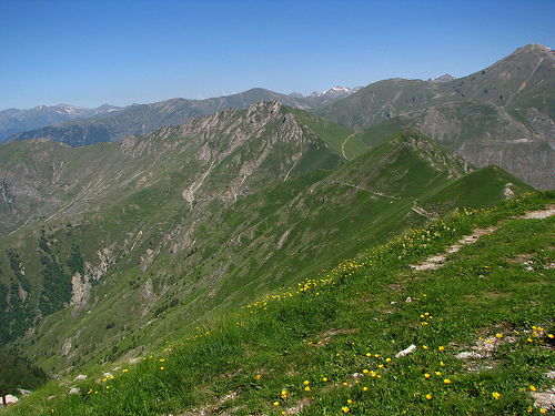
Nestled in the Alpes-Maritimes and Alpes-de-Haute-Provence departments, the park is astonishingly close to the coast—just an hour's drive from Nice—yet ascends into a realm of soaring peaks and secluded valleys. It encompasses seven distinct valleys: Roya, Bévéra, Vésubie, Tinée, Haut Var/Cians, Verdon, and Ubaye, each contributing to its varied topography. Altitudes fluctuate from around 500 meters (1,640 feet) in lush river gorges to summits exceeding 3,000 meters (9,843 feet), with Cime du Gélas reaching 3,143 meters (10,312 feet) as the park's pinnacle. Geologically, the area showcases 300 million years of Earth's history, from crystalline rock massifs to sedimentary layers eroded into striking red-rock canyons like the Gorges de Daluis and Cians. Glacial remnants include pristine lakes such as Lac d'Allos—the largest high-altitude lake in Europe—and the Five Lakes Basin, nourished by rivers including the Var, Tinée, and Vésubie. Climatically, it transitions from mild Mediterranean conditions in the south, with olive groves and lavender, to harsh alpine zones with heavy winter snow and cool summers, fostering a patchwork of habitats from dense forests to barren scree slopes.
Evidence of human activity in Mercantour traces to prehistoric eras, with Neolithic settlements and over 37,000 Bronze Age petroglyphs in the Vallée des Merveilles depicting tools, animals, and figures—a site classified as a Historical Monument and accessible only with guides. Roman roads and fortifications highlight ancient connectivity, while medieval perched villages and centuries-old shepherding practices define its cultural fabric. The park's creation in 1979 stemmed from post-World War II conservation movements, building on earlier hunting reserves and the 1960 national parks legislation to counter urbanization threats from the Riviera. This initiative preserved the Alps' final untouched expanse, now home to 20,000 residents in its peripheral zones who maintain traditional livelihoods. In recent decades, it has adapted to challenges like glacial melting due to climate change, while its 1987 twinning with Alpi Marittime underscores binational stewardship.
As a premier biodiversity enclave, Mercantour harbors more than 2,000
flowering plant species—half of France's total flora—with over 200 rare
or threatened varieties, including Ice Age holdovers and endemics like
the multi-flowered saxifrage. Lower slopes feature Mediterranean
elements such as holm oaks, olive trees, and rhododendrons, giving way
to coniferous forests of fir, spruce, Swiss pine, and vibrant larch
groves that turn golden in autumn. Alpine meadows erupt in spring with
edelweiss, gentians, moss campions, and martagon lilies, creating
colorful carpets. The park's participation in the All Taxa Biodiversity
Inventory underscores its role in cataloging this richness.
Animal
life is equally prolific, with around 9,000 species documented,
including key mammals like chamois (easily spotted on slopes), ibex
(over 1,000 individuals thriving post-reintroduction), mouflon, red and
roe deer, marmots, and elusive lynx. Wolves, returning naturally from
Italy in 1992, now form packs of about 50, coexisting with shepherds
through protective measures like insurance against predation. Avian
highlights include golden eagles, peregrine falcons, buzzards, and the
reintroduced bearded vulture—Europe's largest raptor—along with over 150
bird species. Reptiles such as the Orsini viper, amphibians in streams,
and a wealth of invertebrates—including unique butterflies and
subterranean crustaceans—further enrich its ecosystems, making it a
focal point for underground biodiversity studies.
Mercantour's cultural legacy spans millennia, from prehistoric petroglyphs around Mont Bégo—37,000 engravings of cattle, weapons, and humans from the late Neolithic to Bronze Age—to Roman vias and medieval perched hamlets like Belvédère, Rimplas, and Roubion, with their red-stone roofs and terraced fields. Pastoralism remains vibrant, with summer transhumance sustaining local products like cheeses from high pastures, alongside beekeeping and artisanal crafts. Baroque chapels adorned with murals by Niçois artists, 19th-century military forts, and over 150 rural heritage sites preserve this history, blending human ingenuity with the wild environment.
With 1,123 named mountains and over 550-600 kilometers (342-373 miles) of marked trails, Mercantour is a paradise for adventurers, drawing about 800,000 visitors yearly for hikes along routes like GR 5 and GR 52, which traverse lakes, gorges, and summits. Activities range from multi-day treks and rock climbing to winter skiing at resorts like Isola 2000, river kayaking, and wildlife observation—such as spotting wolf packs at the Alpha Animal Park or chamois on slopes. Cultural excursions include guided tours of the Vallée des Merveilles engravings and visits to the Musée des Merveilles in Tende. Eco-friendly accommodations like mountain refuges and perched village lodges promote immersion, with visitor centers in Tende and Saint-Étienne-de-Tinée offering guidance.
Mercantour prioritizes safeguarding its ecosystems against threats like habitat fragmentation, invasive species, and warming temperatures causing glacial loss. Strategies include biodiversity inventories, reforestation, and wildlife reintroductions (e.g., bearded vultures), alongside farmer support for wolf coexistence. As part of Natura 2000 and a potential UNESCO Biosphere Reserve, it advances research via programs like EDIT and promotes eco-tourism to sustain local economies while limiting impacts through zoning and visitor education. Despite attracting crowds, its "unsung" status helps maintain its pristine character, ensuring it remains a vital refuge for nature.