Location: Haut-Rhin department Map
Info: Palais du Gouverneur,
6 pl d'Armes
Tel. 03 89 72 56 66
www.tourisme-rhin.com
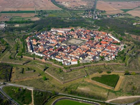
Neuf-Brisach is settlement that arouse on the site of the former fortress in Haut-Rhin department of France. It was designed by Vauban as an octagonal citadel that protected border against German states. It was constructed between 1698 and 1707. It consists of two walls of protection and the city is broken into 48 squares for ease of defense. A central church Eglise St- Louis was added in 1731- 36 and dedicated to the saint patron of French king Louis XIV known as Sun King. If you want to learn more about fortress' history you can visit Musee Vauban at the Porte de Belfort.
1. The Fortifications and Ramparts (Vauban’s Masterpiece)
The
star-shaped walls, bastions, moats, and outer works are the primary
attraction. You can walk along large sections of the ramparts (free
access in many areas) for panoramic views. The system includes:
Deep
moats and canals (including one used to transport red sandstone from the
Vosges).
Eight major bastions and advanced detached works designed to
maximize crossfire and delay attackers.
Well-preserved earthworks and
grassy glacis.
A blue line on the ground guides visitors on a
self-tour. Guided tours (sometimes with costumed guides) provide deeper
insight and access to restricted areas like bastion interiors.
2.
Gates (Portes)
Porte de Belfort (Belfort Gate): One of the main
entrances, housing the Vauban Museum. Impressive stone architecture with
defensive features.
Porte de Colmar (Colmar Gate): The other primary
gate still open to traffic. Both gates showcase Vauban’s monumental
style.
3. Place d’Armes (Central Parade Ground / Market Square)
The heart of the town, a large open square flanked by key buildings.
Originally for military parades and drills, it now serves as a lively
central plaza with markets and events. Its scale and symmetry are
striking.
4. Église Royale Saint-Louis (Royal Church of Saint
Louis)
A prominent Baroque-style church built in the early 18th
century, facing the central square. It features a relatively sober
exterior for the period but serves as a focal point of the town’s grid
layout. It replaced earlier temporary structures.
5. Other
Historic Buildings
Town Hall (Hôtel de Ville): Elegant civic building
on or near the central square.
Governor’s Residence, Arsenal, and
officers’ houses: Several original military and administrative buildings
survive, though many were adapted over time.
The orthogonal street
grid creates a very walkable, uniform townscape with uniform blocks.
6. Vauban Museum (Musée Vauban)
Located under the Belfort Gate.
It features a large scale model of the town and fortifications,
historical documents, maps, artifacts, and information on Vauban’s life
and engineering. A highlight for understanding the defensive system.
7. MAUSA – Musée Art Urbain et Street Art
A more contemporary
attraction inside the historic casemates (underground defensive
chambers). It showcases street art and urban art installations
integrated into the old military architecture, creating a striking
contrast between 18th-century engineering and modern creativity.
Best Time to Visit
Shoulder seasons (May–June and
September–October): Mild weather, fewer crowds, and pleasant conditions
for walking the ramparts. Spring brings blooming surroundings; fall
offers nice light and harvest vibes nearby.
Summer: Good for outdoor
exploration but can be warmer; still relatively uncrowded compared to
Colmar.
December: Consider the themed Christmas market ("Village
1700"), which recreates the Vauban era at the foot of the
ramparts—unique and atmospheric, though busier.
Avoid deep winter if
you dislike cold, as outdoor rampart walks are the highlight.
How
to Get There
By car (easiest): About 20–25 minutes east of Colmar via
the D415. Exit the A35 motorway toward Freiburg/Neuf-Brisach. Free
parking is available in the central Place d'Armes (large square that
doubles as a parking lot) and nearby streets. EV charging is available
near the Tourist Office.
By public transport: Train to Colmar
(well-connected from Strasbourg, Basel, or Mulhouse), then bus (lines
like 301 or 1076). Buses run regularly; check Vialsa or local schedules.
The town is small and walkable once there.
By bike: Excellent
option—flat terrain, on the Rhine cycle route (EuroVélo 15). Loops from
Colmar (around 20–50 km) or along the Rhine plain are popular and
scenic.
From Germany: Short walk or drive across the Rhine from
Breisach am Rhein.
Tip: Rent a car if combining with other Alsace
spots (Colmar, Haut-Koenigsbourg Castle, wine route). The town is
compact (about 1.3 km²), so you don't need transport inside.
Practical Tips
Tourist Office: On Place d'Armes—grab free maps, book
tours, and get current info.
Accessibility: Flat town center;
ramparts involve some walking (check for mobility needs).
Crowds &
Atmosphere: Very low overtourism—quiet and authentic.
With Kids:
Costumed tours, street art, and hunts work well.
Photography: Best
from bastions for aerial-like views of the star shape; golden hour is
magical.
Weather: Bring layers—ramparts are exposed. Comfortable
shoes for cobblestones/grass.
Food and Drink
Alsatian
classics: choucroute garnie (sauerkraut with meats), flammekueche,
pretzels, Munster cheese, and local wines (Riesling, Pinot Gris).
Options are limited but solid—try Hôtel Restaurant Aux Deux Roses or
other spots in/near the center. For more variety, base in Colmar and
day-trip.
Where to Stay
Few options in town (it's small), so
many visit as a day trip.
Hôtel Restaurant Aux Deux Roses: Central,
traditional, with restaurant.
Other guesthouses or nearby in the
Alsace plain. Colmar (20 min away) offers far more hotels and charm if
you want an overnight base.
Nearby Attractions
Colmar (Little
Venice, Unterlinden Museum).
Alsace Wine Route villages.
Breisach
(Germany).
Europa-Park (theme park, short drive).
Rhine cycling or
thermal baths.
Origins: The Loss of Breisach and Strategic Need
The story
begins with the older town of Breisach am Rhein (Old Breisach) on
the right bank of the Rhine in what is now Germany. This medieval
stronghold controlled a key Rhine crossing and had been a strategic
prize for centuries. During the Thirty Years’ War and subsequent
conflicts, France under Louis XIV seized it in 1639/1664. Vauban
himself fortified and improved Breisach between roughly 1664 and
1670.
The Treaty of Ryswick (1697), ending the War of the League
of Augsburg, forced France to return Breisach (and other
territories) to the Holy Roman Empire (Habsburg Austria). This
created a dangerous gap in France’s eastern defenses along the Rhine
between Huningue and Strasbourg. Louis XIV ordered Vauban to design
a replacement fortress on the French (left) bank to secure Alsace
and counter the lost stronghold.
Vauban surveyed the area and
chose a flat site a few kilometers west of the Rhine—close enough to
monitor and threaten Breisach but out of range of its cannons. He
presented three plans; the king selected the most ambitious and
expensive: a completely new "ideal city" built from scratch with the
most advanced fortifications of the era.
Construction
(1698–1702/1706): Vauban’s Third System Masterpiece
Construction
officially began in 1698 (some sources cite 1699 for major
stonework) under the direction of Jacques Tarade, with oversight
from Vauban. It was a massive engineering feat completed in roughly
four years, involving 1,500–2,000 workers daily.
Materials and
Logistics: A dedicated canal (the Vauban or Neubreisacher canal) was
dug to transport pink sandstone from the Vosges Mountains (about 30
km away) via barges. Rubble from the demolished French works at
Breisach was also reused.
Design: The town is laid out as a
perfect octagon with a regular grid street pattern inside. It
features a double defensive system (Vauban’s “third system,” his
most advanced):
Inner enceinte de sûreté: A bastioned wall with
curtain walls, towers, and echauguettes (watchtowers).
Outer
enceinte de combat: Concentric star-shaped earthworks including
detached bastions, tenailles, ravelins (some with reduits), a
covered way with traverses, counterscarp, and a broad glacis.
Eight large pentagonal bastion towers at the corners.
Four main
gates (Belfort, Colmar, Strasbourg, Basel) with drawbridges,
portcullises, and guardrooms.
Urban Planning: Centered on a
large parade ground (Place d’Armes) with a church (Église
Saint-Louis, built 1731–1736), town hall, governor’s residence,
arsenal, and other military buildings. Housing included grander
homes in gardens for officers and denser tenement blocks along the
ramparts (which doubled as bomb shelters with vaulted cellars). The
design balanced military needs with a functional garrison town for
up to ~4,000 people.
Vauban died in 1707; his successor Louis
de Cormontaigne helped complete aspects of the work. Some elements
(like the northeast crownwork and full completion of the Belfort
gate) were never finished, partly because France recaptured Breisach
during the War of the Spanish Succession (Vauban’s last major siege
in 1703).
18th–19th Centuries: Limited Military Role and the
Franco-Prussian War
For much of the 18th century, Neuf-Brisach
served primarily as a garrison town and deterrent rather than seeing
major action (a brief alert in 1743 aside). Its strategic importance
waned somewhat after France’s borders shifted.
Its big test came
during the Franco-Prussian War (1870–1871). Prussian forces
bombarded it heavily from November 2–10, 1870, firing over 6,000
shells. The town capitulated after sustaining significant damage.
Following the war and the annexation of Alsace-Lorraine by the
German Empire (1871), the Prussians repaired and modified the
fortifications—elevating parapets to counter rifled artillery and
replacing some drawbridges with fixed ones. Many buildings were
rebuilt according to the original plans.
20th Century: World Wars
and Occupation
World War I: The town returned to France in
1918.
World War II: It was in the Maginot Line zone; civilians
were evacuated in 1939. Germany occupied it from June 1940 and used
it as a transit/Dulag prison camp for tens of thousands of French
POWs. In 1945, as Allied forces advanced, the town was heavily
bombed (over 85% destruction in some accounts) by Americans who
mistakenly believed it was still occupied. Remarkably, the
fortifications themselves survived largely intact.
Post-war
reconstruction restored the town’s historic layout while modernizing
the interior.
Modern Era and Preservation
Today,
Neuf-Brisach has a population of around 1,900. The ramparts are
well-preserved and open for walking tours, offering excellent views
of the star-shaped design. It features a Vauban Museum (housed in
the incomplete Belfort gate) with models, documents, and exhibits on
its history.
The town is a prime example of 17th–18th century
military urbanism and Vauban’s lasting influence on European
fortification design (his "iron belt" around France included over
160 sites). Its UNESCO status highlights its outstanding universal
value in military architecture, urban planning, and the history of
siege warfare.
Location and Coordinates
Geographic coordinates: Approximately
48°01′04″N 7°31′43″E (48.0177°N, 7.5285°E).
Elevation: 194–198 m
(636–650 ft) above sea level, with an average of about 197 m (646 ft).
The terrain is remarkably flat.
It lies in the Upper Rhine Plain
(Plaine d'Alsace), a broad, low-lying alluvial valley.
The town
is positioned strategically a few kilometers west of the Rhine River,
which forms the modern border with Germany. Directly opposite, on the
German (right) bank, is its historical counterpart, Breisach am Rhein
(Old Breisach). This placement allowed it to guard the border and
control crossings after France lost Breisach under the 1697 Treaty of
Ryswick.
It is about 15–20 km east of Colmar, the nearest major town,
and sits in the Alsace Rhin Brisach intercommunality.
Topography
and Terrain
Neuf-Brisach occupies an exceptionally flat site in the
Rhine floodplain, chosen deliberately for military engineering purposes.
The surrounding landscape consists of:
Fertile alluvial plains used
for agriculture (cereals, corn, and other crops).
Remnants of the
Rhine's historical river dynamics, including canals and former channels.
The town itself covers only about 1.33 km² (very compact).
The
natural flatness was ideal for constructing an "ideal city" with perfect
geometric symmetry. Vauban enhanced this with extensive earthworks: deep
moats, ramparts, bastions, ravelins, tenailles, a covered way, and a
glacis (sloped open ground) that extend well beyond the urban core. The
outer fortifications occupy more land than the town itself.
The
star-shaped (octagonal with projecting bastions) design is a masterpiece
of Vauban's "third system" of fortification—his final and most advanced
work.
Aerial views highlight the striking contrast between the
geometric town/fortifications and the surrounding patchwork of fields
and modern infrastructure.
Hydrology and Water Features
The
Rhine River is the dominant regional feature, lying a few kilometers to
the east. Historically vital for defense and transport.
A canal
(Neubreisacher canal) was built during construction to transport
materials.
The area connects to the broader Rhine waterway network,
including links to the Rhône-Rhine Canal system, supporting navigation
and historically aiding logistics.
Climate
Neuf-Brisach has a
temperate oceanic climate (Köppen Cfb) influenced by its position in the
Rhine Valley, shielded somewhat by the Vosges Mountains to the west and
the Black Forest to the east. Key characteristics:
Mild temperatures
year-round.
Moderate to high precipitation distributed fairly evenly,
with no extreme dry season.
Warm summers (average highs above
72°F/22°C from June to early September) and cool winters.
The flat,
open plain can experience fog, especially in cooler months, and
occasional Rhine-related humidity.
Human and Strategic Geography
Built from scratch starting in 1698–1699 on Louis XIV's orders to
Vauban, the town exemplifies 17th–18th century military urban planning:
Internal layout: A regular square grid of streets forming 48 quarters
around a central parade ground, inside an octagonal walled core. This
"ideal city" design included housing, a church, and defensive
integration.
Fortifications: Double lines of defense (inner safety
wall and outer combat earthworks) with eight bastions, making it one of
the best-preserved examples of Vauban’s work. It is a UNESCO World
Heritage Site (part of the "Fortifications of Vauban" group since 2008).
The surrounding region is part of the culturally rich Alsace, with
its mix of French and German influences, vineyards (though more
prominent westward toward the Vosges foothills), and agricultural
productivity.