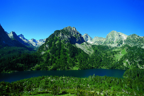
Location: Hautes-Pyrénées, Pyrénées-Atlantiques Map
Area: 457 km²
Parc national des Pyrénées (Pyrenees National Park) is one of
France’s 11 national parks, established in 1967. It spans the
Hautes-Pyrénées and Pyrénées-Atlantiques departments along the
France-Spain border. The park covers a core "heart" zone of
about 45,700 hectares under strict protection and a larger
adhesion zone for sustainable development.
It features
dramatic glaciated landscapes: high peaks (over 3,000m), immense
limestone cirques (like Gavarnie, a UNESCO site with Spain’s
Pyrénées-Mont Perdu), U-shaped valleys, waterfalls, over 230
high-altitude lakes, ancient forests, and rich biodiversity.
It’s a paradise for hikers, nature lovers, and wildlife
watchers.
Best Time to Visit
Peak hiking season: Late June to mid-September.
Trails are mostly snow-free, weather is mildest (daytime 15–25°C/59–77°F
at lower elevations), and refuges are open. July–August is busiest with
higher prices and crowds at iconic spots.
Shoulder seasons (late
May–early June or September): Fewer crowds, beautiful spring flowers or
autumn colors, but higher passes may still have snow, and some services
close. Weather is more variable.
Winter: Snowy and scenic for
cross-country skiing or snowshoeing, but many trails and high areas are
inaccessible or require specialized gear/experience. Shorter days.
Weather notes: Mountain weather changes rapidly—always prepare for rain,
wind, cold, and sudden storms. The French side is generally wetter than
the Spanish side due to Atlantic influences.
How to Get There
The park is accessible but not huge on public transport, so a car offers
the most flexibility. Key gateway towns include Cauterets (great for
Pont d’Espagne/Lac de Gaube/Vignemale area), Luz-Saint-Sauveur,
Gavarnie-Gèdre (for the cirques), Argelès-Gazost, and towns in the Ossau
or Aspe Valleys (western side).
By air: Nearest airports are
Lourdes-Tarbes-Pyrénées (LDE, ~30–50 km) and Pau-Pyrénées (PUF, ~80 km).
Toulouse-Blagnac (TLS) is larger but farther (~2–2.5 hours drive).
By
train + bus: TGV to Lourdes or Pau, then local buses (liO lines, e.g.,
965) or shuttles to Cauterets, Gavarnie, etc. Summer shuttles run to
trailheads like Pont d’Espagne.
By car: From Toulouse ~2–2.5 hours to
Cauterets/Gavarnie via A64. From Bordeaux ~3 hours. Mountain roads are
winding but well-maintained; parking at popular sites can fill up in
peak season.
Tip: In summer, use park shuttles where available to
reduce traffic and parking stress.
Top Attractions and Hiking
The park has hundreds of kilometers of marked trails (part of the GR10
long-distance path). Difficulty ranges from easy valley walks to
strenuous high-mountain routes. Popular highlights:
Cirque de
Gavarnie — Iconic amphitheater with Europe’s highest waterfall (~427m
drop). Moderate 10–11 km round-trip from Gavarnie village (4–5 hours).
Stunning views; can extend to higher points.
Pont d’Espagne & Lac de
Gaube (near Cauterets) — Waterfalls, emerald lake, and views toward
Vignemale (highest peak entirely in France at 3,298m). Moderate 8+ km
options; cable car or shuttle helps.
Néouvielle Nature Reserve
(eastern part) — Granite landscape with dozens of lakes, ancient pines.
Great for multi-day circuits.
Ossau Valley & Pic du Midi d’Ossau —
Dramatic peak with lake circuits (e.g., Lacs d’Ayous).
Other gems:
Cirques de Troumouse and Estaubé, Lac d’Estom, various high passes.
Multi-day options: Hut-to-hut treks along GR10 or loops staying in
refuges. Day hikes suit most visitors.
Trail resources: AllTrails,
park maps, or local tourist offices. Apps like Visorando or IGN maps are
useful. Guided hikes are available for safety or interpretation.
Accommodations
Base towns: Cauterets (lively, thermal spas, close to
trails), Luz-Saint-Sauveur (charming, strategic), Gavarnie (immersive
but smaller), Argelès-Gazost, or Ossau Valley villages like Laruns.
Options: Hotels, gîtes (guest houses), campsites, Airbnbs. Book early
for July–August.
Mountain refuges: Guarded huts offer meals and dorm
beds (~€20–60/night, book ahead). Basic unguarded shelters exist. Ideal
for multi-day hikes.
Camping/bivouac: Bivouacking (light overnight)
allowed in the heart of the park from 7pm–9am, at least 1 hour’s walk
from roads/trailheads. No fires; follow Leave No Trace.
Rules and
Practical Tips
Free entry — No entrance fee, but respect regulations.
Strict rules (especially in core zone): No picking flowers/plants, no
dogs (even leashed), no drones, no wild camping outside allowed times,
stay on trails, pack out all trash. Fishing/hunting restricted.
Safety:
Check weather forecasts (Météo France).
Wear sturdy hiking
boots; bring layers, rain gear, headlamp, first aid, water (2L+),
map/compass/GPS.
Altitude sickness possible; acclimatize.
Tell
someone your plans; consider a mountain insurance.
In summer,
thunderstorms are common in afternoons.
What to pack extra:
Sunscreen (high altitude), trekking poles, cash for some
refuges/shuttles, insect repellent.
Sustainability: Support local
businesses, use public transport/shuttles, and follow "Esprit Parc
National" principles.
Accessibility: Some lower trails and visitor
centers are easier, but the park is mountainous overall—check specifics
for mobility needs.
Additional Activities
Beyond hiking:
Wildlife watching, photography, thermal spas (Cauterets has a history),
cycling, horseback riding, winter sports, or cultural visits to nearby
Lourdes or traditional Pyrenean villages.
Pro tips:
Spend at
least 3–5 days to explore different valleys—don’t try to see everything
in one day.
Combine with the Spanish side (e.g., Ordesa) for a fuller
Pyrenees experience if time allows.
Visit local tourist offices or
the park’s visitor centers for up-to-date maps, conditions, and guided
programs.
Geological and Deep Prehistory
The Pyrenees formed roughly 100–66
million years ago from the collision of the Iberian and Eurasian
tectonic plates, creating a rugged range with peaks over 3,000 meters,
deep cirques, canyons, and valleys. Human presence in the region dates
back to the Upper Paleolithic (40,000–10,000 BCE), with evidence from
caves like Añisclo and Escuain, stone circles at Gavarnie, and dolmens.
Ancient and Medieval Human History: Pastoralism and Transhumance
The park’s cultural landscape is deeply shaped by agro-pastoralism and
transhumance (seasonal livestock movement), which have defined the
Pyrenees for millennia. Neolithic and later periods saw early farming
and grazing. By the Middle Ages, a sophisticated transhumance system
developed, with communities moving sheep, cows, and horses to high
summer pastures. This created a unique cross-border culture where
mountain valleys shared more ties with each other than with lowland
plains.
Ancestral agreements (some dating to the 13th century)
governed grazing rights, including Spanish herders using French
pastures. Features like pastoral huts (mallatas), trails, bridges, and
high pastures (e.g., Gaulis or Ossoue) testify to this enduring system.
Transhumance remains active today, supported by the park and EU
policies, and is recognized as intangible cultural heritage.
19th–Early 20th Century: Exploration, Development, and Early
Conservation
The 19th century saw increased scientific and touristic
interest. Figures like Ramond de Carbonnières explored peaks (e.g.,
first ascent of Monte Perdido/Mont Perdu in 1802). Hydroelectric
projects in the 1920s, such as dams, led to infrastructure like the
Petit Train d'Artouste.
On the Spanish side, the Ordesa y Monte
Perdido National Park was created in 1918 (one of Spain’s oldest) to
protect species like the Spanish ibex. France saw classified sites
(e.g., Gavarnie, Troumouse, Estaubé in 1941) and hunting reserves. Rural
depopulation in the early-to-mid 20th century reduced grazing pressure,
leading to vegetation changes (e.g., forest regrowth and shifts in
floristic diversity).
Establishment of the French National Park
(1967)
The Parc national des Pyrénées was formally created by
governmental decree in 1967 as one of France’s early national parks
(following Vanoise and Port-Cros in 1963). Its core mission emphasizes:
Protecting exceptional natural heritage without fences or barriers,
allowing free movement of wildlife.
Preserving biodiversity and
landscapes.
Enabling public access and appreciation (“make nature
available to all”).
Scientific study and sustainable management.
It covers six main valleys with elevations from about 1,060 m to 3,298 m
(Vignemale). Unlike stricter “integral” reserves, it balances
conservation with traditional activities like limited pastoralism. A
buffer or “adhesion” zone involves surrounding communities.
Post-Establishment Developments and UNESCO Recognition
In 1997, the
eastern portion (around Mont Perdu) was inscribed on the UNESCO World
Heritage List as part of the Pyrénées – Mont Perdu site (shared with
Spain’s Ordesa y Monte Perdido). This recognizes both natural
(geological, scenic) and cultural (transhumance landscape) values under
multiple criteria. A small French extension was added in 1999.
The
park has faced challenges like rural exodus, balancing tourism (over 1.5
million visitors annually), species reintroductions (e.g., Pyrenean ibex
in 2014, brown bears), and modern pressures (climate change,
infrastructure). It collaborates transboundary with Spain on management,
research, and sustainable development.
Key Conservation
Milestones and Ongoing Role
1960s–1970s: Formal protection and early
scientific monitoring.
1980s–present: Focus on biodiversity (70+
mammal species, rich flora, birds like golden eagles), rewilding, and
eco-tourism.
Integration into Natura 2000 and other frameworks.
Support for pastoralism as a landscape-maintaining practice amid
depopulation.
Topography and Key Features
The park features dramatic alpine
terrain with elevations ranging from about 1,060 m (3,478 ft) in the
lower valleys to 3,298 m (10,820 ft) at Pique Longue du Vignemale, the
highest peak in the French Pyrenees.
Six principal north-south
valleys: From west to east, these include the Aspe, Ossau, Azun,
Cauterets, Luz-Gavarnie, and Aure valleys. These valleys, carved by
rivers and glaciers, define the landscape and provide access points.
Cirques and Glacial Features: Iconic U-shaped glacial cirques dominate,
especially in the Gavarnie area. The Cirque de Gavarnie is renowned,
with walls up to 1,500 m high and one of Europe’s tallest waterfalls
(Grande Cascade de Gavarnie, ~422 m drop). Nearby are the larger Cirque
de Troumouse and the more secluded Cirque d’Estaubé. These formed during
Quaternary glaciations.
Peaks and Massifs: Notable summits include
Vignemale (with its north face and glaciers), Pic du Midi d’Ossau (an
ancient volcano-like peak at 2,884 m), and parts of the Balaïtous
massif. Mont Perdu (3,352 m / 10,990 ft) anchors a major limestone
massif with French-side cirques.
Lakes, Rivers, and Waterfalls: Over
230 high-altitude glacial lakes (e.g., Lac de Gaube), cascading
waterfalls, torrents, and river ravines. Features like Pont d’Espagne (a
natural bridge) are popular gateways.
Varied Rock Formations:
Granite, gneiss, schist, and limestone create diverse scenery—granite
massifs (e.g., Cauterets), limestone karst (Gavarnie), and mixed zones.
Tectonic uplift and erosion produced deep canyons and cliffs.
The
terrain is rugged, with steep slopes, rocky peaks (often snow-capped),
alpine meadows, and forested lower slopes. It suits hiking, climbing,
and skiing but requires preparation due to its remoteness and weather.
Geology
The Pyrenees are a relatively young range (Alpine
orogeny) formed mainly by the collision of the Iberian and Eurasian
plates starting ~65–100 million years ago (late Cretaceous to
Eocene/Oligocene), with major uplift in the Eocene. This renewed an
older Hercynian (Variscan) basement from ~370–290 million years ago.
Rocks include ancient granites and metamorphics in the axial zone, plus
sedimentary layers (limestones from Cretaceous/Eocene periods) that form
karst features, cirques, and canyons. Glacial and fluvial erosion during
the Quaternary shaped the modern landscape, creating U-shaped valleys
and cirques. The range shows asymmetry: steeper northern (French) slopes
in places and varied north-south structures with pre-Pyrenean ridges.
Climate
The park sits at the transition between Atlantic
(oceanic) and Mediterranean influences, with strong west-east and
north-south gradients. Western areas receive more moist Atlantic air,
leading to higher precipitation (rain and snow) and denser vegetation.
Eastern sections are drier. Northern slopes are more humid and maritime;
southern ones lean Mediterranean.
Winters are cold (average ~
-2°C / 28°F at higher elevations), with heavy snow.
Summers are mild
to cool, with possible thunderstorms.
Precipitation is higher in the
west/central areas; snow persists at high elevations, supporting small
glaciers (though retreating due to climate change).
Altitudinal
zonation creates microclimates from temperate valley floors to harsh
alpine/nival zones above treeline (~1,800–2,000 m).
Vegetation
and Ecosystems
Vegetation follows elevation bands:
Lower
slopes/forests (up to ~1,800 m): Mixed deciduous (downy oak, silver
birch, ash, willows) and conifers (Scots pine, silver fir, yews).
Subalpine (~1,800–2,000+ m): Mountain pine dominates.
Alpine meadows
(higher): Grasses, flowers like edelweiss, bellflower, Pyrenean violet,
long-leafed butterwort, Pyrenean lily, ramonda (a Tertiary relict), and
saxifrages. About 2,500 plant species total, with ~200 endemics.
Above treeline, rocky peaks are largely bare or snow-covered. The park
protects biodiversity hotspots with varied geology and climate.
Wildlife
The park hosts rich fauna typical of the Pyrenees:
Mammals — Pyrenean chamois (emblematic), brown bears (reintroduced,
small population), marmots, boar, red deer, desman (endemic aquatic
mammal), badgers, and squirrels.
Birds — Golden eagles, griffon
vultures, bearded vultures, western capercaillie, and others.
Other
species — Amphibians like the common midwife toad; diverse insects.
It supports ~70 mammal species and thousands of animal species overall,
with many protected or endemic.
Human and Conservation Context
The park preserves natural heritage while allowing sustainable
activities (hiking, limited grazing). It includes 64 municipalities and
cultural elements like transhumance (seasonal herding). No permanent
habitation exists in the strict core zone, which has regulations to
protect the environment.
Flora: Zoned Vegetation and Endemism
The park hosts roughly 2,500
plant species (with estimates up to 4,500 including subspecies in
broader Pyrenean contexts), including 80–200 endemic or sub-endemic
species. Vegetation follows clear altitudinal bands shaped by
temperature, snow cover, wind, and soil.
Collinean/Montane
Forests (up to ~1,700–1,800m): Dominated by broadleaf trees like beech
(Fagus sylvatica), sessile oak (Quercus petraea), and mixed woods with
silver fir (Abies alba), Scots pine (Pinus sylvestris), yews, and ashes.
These lower slopes feature rich understories with ferns, wildflowers,
and shrubs.
Subalpine Zone (~1,700–2,400m): Mountain pine (Pinus
uncinata / black pine) dominates, often forming open stands.
Rhododendrons (Rhododendron ferrugineum), junipers, and colorful meadows
appear here. This zone marks the transition to treeline.
Alpine Zone
(above ~2,400m): Treeless meadows, rocky screes, and snowfields host
hardy, low-growing species adapted to short growing seasons, intense UV,
and poor soils. Flowering is synchronized with snowmelt in late
spring/early summer, creating spectacular displays.
Notable and
Endemic Plants:
Pyrenean lily (Lilium pyrenaicum) — striking yellow
flowers.
Ramonda pyrenaica (Pyrenean ramonda) — a "resurrection
plant" that survives extreme desiccation.
Pyrenean iris or English
iris.
Saxifrages (e.g., Saxifraga longifolia, S. iratiana) — many
endemic species cling to rocks.
Borderea pyrenaica — from a genus
endemic to the Pyrenees.
Androsace pyrenaica (Pyrenean rock jasmine).
Edelweiss (Leontopodium alpinum), gentians (Gentiana spp.), Pyrenean
violet, long-leaved butterwort (Pinguicula longifolia), alpenrose, and
bellflowers.
Other highlights: Pyrenean squill and various orchids.
The park's flora shows high endemism due to the Pyrenees acting as a
glacial refuge and biogeographic barrier. Picking flowers is strictly
forbidden to protect these fragile populations.
Fauna: Iconic
Mammals, Birds, and Specialists
The park supports around 70 mammal
species (out of ~167 in mainland France), over 170 bird species, plus
rich reptile, amphibian, fish, and invertebrate communities. Total
animal species often cited exceed 4,000 when including insects.
Mammals
Pyrenean Chamois (Rupicapra pyrenaica pyrenaica, locally
"isard"): The park's emblem, with thousands of individuals. Agile
goat-antelopes thriving on steep slopes up to 3,000m.
Brown Bear
(Ursus arctos): Small but recovering population (reintroduced
individuals; historically native). Shy and elusive, mainly in
central/western areas. Controversial due to occasional livestock
conflicts.
Alpine Marmot (Marmota marmota): Common in high meadows;
reintroduced or naturally present. Often seen basking or whistling
alarms.
Wild Boar, roe deer, red deer, red fox, badger, stoat/ermine,
weasel, and otters in rivers.
Pyrenean Desman (Galemys pyrenaicus):
Highly specialized, semi-aquatic insectivore (related to moles) with a
snorkel-like snout and webbed feet. Rare, endemic to the Pyrenees and
northern Iberia; threatened by water pollution and habitat alteration.
Birds
Raptors: Golden eagle, griffon vulture (common and
soaring), bearded vulture/lammergeier (iconic bone-breaker with
reintroduction success), Egyptian vulture, peregrine falcon.
Western
Capercaillie (Tetrao urogallus): Large, threatened forest grouse.
Rock Ptarmigan: High-altitude specialist that changes plumage
seasonally.
Others: Wallcreeper, citril finch, ring ouzel, and
various owls and woodpeckers.
Other Groups
Reptiles and
Amphibians: Common midwife toad (endemic subspecies or notable
populations), lizards (including some high-altitude specialists), and
snakes.
Invertebrates: Extremely diverse, with many endemic
butterflies, moths (e.g., Spanish moon moth), and other insects. Rich
aquatic life in streams and ~300 lakes.
Ecological Context and
Conservation
The park's biodiversity stems from its position as a
meeting point of Mediterranean, Atlantic, and Alpine influences, plus
glacial history creating isolated habitats. Pastoralism (transhumance of
sheep, cows, goats) has shaped landscapes for centuries, maintaining
open meadows that support wildflowers and herbivores.
Threats include
climate change (affecting snow cover and high-altitude species), tourism
pressure, and human-wildlife conflict (e.g., bears). Strict regulations
apply in the core zone: no dogs (even leashed), no picking plants, no
camping outside designated areas, and controlled access in sensitive
spots.
Rangers and scientists conduct long-term monitoring. The park
offers guided wildlife observation, especially in summer.