Location: Saint-Geniez-ô-Merle, Corrèze département Map
Constructed: 12th and 15th century
Official site
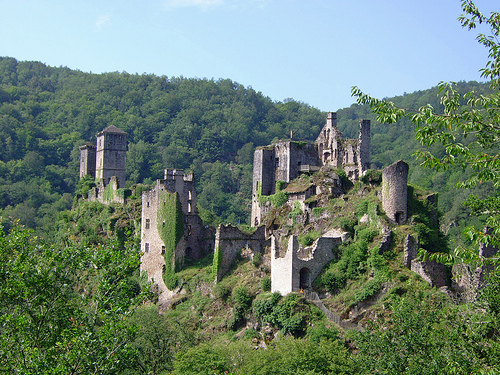
Tours de Merle (Les Tours de Merle), also known as the Towers of Merle, is a unique medieval castrum (fortified settlement) rather than a single castle. It sits in the Corrèze department of Nouvelle-Aquitaine, in the heart of the Xaintrie region, perched dramatically on a rocky promontory overlooking a meander of the Maronne River (a Dordogne tributary).
Getting There
Location: Saint-Geniez-ô-Merle, Corrèze. It's remote
and scenic, reached via winding D13 departmental roads (some narrow
single-lane sections).
Driving distances: ~45 min from Aurillac, 1
hour from Tulle, 75 min from Brive-la-Gaillarde.
Public transport:
Limited; nearest stations are in Tulle (~35 km), Aurillac, or Brive (~45
km). A car is strongly recommended.
Parking: Free lot available.
Expect a noticeable downhill walk from the parking area to the entrance
(and a climb back up afterward). Pass through a small hamlet with a gift
shop/snack bar.
Tip: Drive carefully on the narrow, twisting roads,
especially in poor weather. GPS works but can be unreliable in deep
valleys.
Opening Hours and Pricing (2026 Season)
The site is
typically open from early April to late October (Easter to All Saints'
period). Hours vary by month:
April: Daily ~10:30 AM–6 PM.
May–June: Often closed Tuesdays; afternoons or extended hours.
July–August: Daily ~10 AM–7 PM (peak season).
September–October:
Afternoons, with some days closed; extended during holidays.
Last
entry is usually 1 hour before closing. Check the official website
(toursdemerle.fr) closer to your visit for exact 2026 dates, as they can
shift.
Prices (approximate, vary by season):
Adults:
€5.50–€9.50.
Reduced/child: €5–€7.50.
Free for children under 6.
Guided tours or special events cost extra.
Visiting Tips
Duration: Allow 1–2 hours for a self-guided visit (longer with a guided
tour or if picnicking). The site spans about 10 hectares with paths
between towers.
Access and Mobility: Steep, uneven rocky paths,
narrow/dark staircases inside towers, and climbs to terraces. Not
suitable for wheelchairs, strollers/pushchairs, or those with
significant mobility issues. Good walking shoes with grip are essential
— several visitors report ankle sprains on descents.
Self-Guided
vs. Guided:
Free visit with a welcome booklet (available in English
and other languages) explaining the towers, strategic importance, and
daily life.
Highly recommended: Guided tours (1.5 hours) with
costumed guides or lecturers for deeper immersion. Themed events
("Naturally Medieval") and family activities occur, especially in
summer.
Some visitors praise audio guides or apps for comprehensive
info.
Best Time to Visit:
Spring/Fall: Fewer crowds, pleasant
weather, good for hiking.
Summer: Longer hours but busier; lush
greenery.
Early morning or late afternoon for softer light and fewer
people. Avoid midday heat in July/August.
What to Bring:
Sturdy shoes.
Water and snacks (picnicking is allowed; nice spots
near the river).
Binoculars for birds of prey.
Rain jacket
(weather can change quickly).
Flashlight/phone light for darker tower
interiors.
Dogs: Allowed on leash.
Facilities: Toilets and
basic services near the entrance. No facilities inside the main ruins.
Gift shop and snack options nearby.
Highlights and Experiences
Climb the towers for breathtaking panoramic views over the river and
forests.
Explore the ruins freely, squeezing through narrow passages.
Walk down to the Maronne River for the old stone bridge remains and a
peaceful picnic spot.
Look for medieval farm/garden areas and
reenactments in season.
The site’s isolation enhances the
atmospheric, almost mystical feel.
Safety Note: Paths are rugged with
limited railings. Watch children and take it slow on stairs.
Nearby Attractions and Combining Visits
Picturesque villages like
Laroquebrou, Curemonte, Argentat-sur-Dordogne, or Beaulieu-sur-Dordogne.
Dordogne Valley sites, other Corrèze castles, or hiking in the
surrounding gorges and oak forests.
Combine with a road trip through
the "Land of 1001 Castles."
Origins and Early Development (11th–13th Centuries)
The exact
origins are somewhat obscure and lost in the "mists of the 11th
century," but the site was likely chosen for its naturally defensible
position overlooking a key transport route and acting as a border
stronghold between the Duchy of Aquitaine, the County of Auvergne, and
influences from the County of Toulouse, as well as between two dioceses.
The name "Merle" may derive from the bird (blackbird, common in the
area) or from "merlon" (the solid part of a battlement between
crenellations).
A first tower or fortified house was probably built
in the late 11th or early 12th century by the Merle family, possibly
with authorization from the Counts of Turenne. This family is attested
from the end of the 11th century.
Over time, it evolved into a
castrum—not a single castle owned by one lord, but a shared fortified
community with multiple donjons (tower houses), residences, ramparts,
and supporting village structures. Each noble family built and
maintained its own tower within the enclosure.
By the 13th
century, several families had established themselves through alliances,
marriages, and shared defense:
Merle family (core family, with
branches like those of Hugues, etc.).
Allies and co-seigneurs:
Veyrac, Saint-Bauzille (or Saint-Bauzile), Rochedragon.
Southern end:
Carbonnière (who gradually became dominant, with other families paying
homage to them by 1294) and Pesteils (Pestels/Pesteil, who arrived via
marriage around the early 13th century—Aymeric de Pesteil with Hélis de
Merle).
Other families mentioned include Noailles, d'Alboy, and
Veilhan. Seven families cohabited or succeeded each other, building
square-plan towers to maintain strength without dispersing.
The first
documentary mention of the site dates to 1219.
Peak Period (14th
Century)
At its height around 1350, the castrum was a thriving,
self-contained feudal community:
Seven fortified houses/towers
(maisons fortes or donjons).
Two chapels (one dedicated to Saint
Léger; the site notably lacked a full parish church).
A village with
about 30 houses/cottages, gardens, and orchards.
Roughly 100
inhabitants: nobles, artisans, peasants, woodcutters, priests, and legal
professionals.
It functioned as the center of a châtellenie (a
territorial lordship) with a toll (péage) and mutual obligations:
villagers paid rents/taxes and provided labor in exchange for
protection, use of mills/ovens, and justice. The co-seigneurs shared
power in an unusual "co-seigneury" arrangement, with each controlling
their tower while collaborating on defense.
Conflicts and Decline
(14th–17th Centuries)
The site's military role brought both
importance and vulnerability:
Hundred Years' War: English forces
(active in the region since 1357) captured one tower and a castle in
1371 but were pushed out. The site suffered during the broader chaos.
A period of relative peace and prosperity followed around 1475 after the
war.
Wars of Religion: In 1574, Calvinist (Protestant) forces seized
the citadel and held it as a garrison for nearly two years until the
co-seigneurs recaptured it in 1576.
The rise of artillery made the
elevated but exposed position vulnerable to bombardment from surrounding
heights, reducing its defensive value. By the late 16th–17th centuries,
the noble families increasingly preferred more comfortable and
accessible residences elsewhere, leading to abandonment of the castrum.
The supporting village population dispersed without noble protection.
Some occupation continued at the base into the early 20th century, but
the site fell into ruin.
Later History and Preservation
The
ruins were classified as a historic monument (Monument Historique) on
July 30, 1927. Today, the site (about 10 hectares) is owned by the
commune and open to the public as a tourist attraction, with remains
including towers (notably the better-preserved Pesteils towers), houses
(e.g., of Fulcon, Pierre, and Hugues de Merle), wall sections, chapel
sites, and defensive features.
It draws around 25,000 visitors
annually and is promoted for its atmospheric, almost mystical setting
amid wild oak forests, evoking Game of Thrones-like imagery. Guided
tours and events help interpret the site.
Overall Layout and Historical Context
Construction began around
the late 11th–12th century and continued through the 15th century. At
its peak in the 14th century (around 1350), the site housed seven
separate donjons (towers/fortified residences), two chapels, and about
30 houses/cottages for nobles, artisans, and villagers—totaling over a
hundred inhabitants.
It was a co-seigneury (shared lordship or
coseigneurie), where multiple noble families (primarily the Merle,
Pesteils, Carbonnières, Veyrac, Saint-Bauzile, and others) each built
and occupied their own tower while sharing governance, defenses, and
resources like tolls from a river bridge.
This "gated community" for
medieval aristocrats lacked the classic single keep, moat, or extensive
ramparts of a typical castle; the rocky spur and river provided primary
defense, supplemented by the clustered towers.
The site declined
after the Wars of Religion (16th century), when it was damaged and
abandoned by the nobility for more comfortable residences elsewhere. It
is now a protected historic monument (classified in 1927) and open to
visitors as ruins.
Architectural Features
The architecture is
typical of medieval Limousin and Auvergne regional styles, blending
defensive military elements with residential comfort for the period. The
towers were built primarily of local stone (granite and schist), with
thick walls for strength.
Key characteristics include:
Multiple Independent Donjons/Towers: Seven towers (or fortified houses)
were built over time, often square or rectangular in plan. They were
positioned along the rocky platform rather than as one unified
structure. The Pesteils towers (at the southern end) are among the
best-preserved examples—tall, imposing, with visible multi-level
structures. Other notable remains include those linked to the Merle,
Carbonnière, and Noailles families.
Crenellations and Battlements:
Towers featured crenellated (notched) tops for defensive archery and
observation. These provided a commanding view over the river valley and
surrounding forests.
Interior Residential Features (indicating
relative comfort):
Multiple Fireplaces: Large chimneys and fireplaces
on several levels for heating and cooking, suggesting the towers were
lived in year-round by noble families.
Large Windows: Unlike many
stark military keeps, these had relatively generous windows (including
mullioned examples), allowing light and some ventilation while
maintaining defensibility.
Gothic Doorways and Architectural Details:
Pointed Gothic arches in doorways and openings, reflecting 13th–15th
century influences. Remains of grand fireplaces, staircases, and room
divisions show multi-story living spaces.
Supporting Structures:
Remains of fortified houses, walls, and enclosures.
Two chapels (one
13th-century family chapel inside the walls; another rebuilt in 1674).
Village ruins below the main platform with thatched cottages, gardens,
and orchards.
Defensive elements like murder holes (for dropping
projectiles), latrines, and possibly a drawbridge (Veilhan area).
Construction Evolution: Early towers (11th–12th centuries) were
simpler for basic defense. Later additions (13th–15th centuries)
incorporated more refined Gothic elements and residential comforts as
the co-seigneury prospered. The clustered design emphasized shared
defense without a central dominant keep.
The site integrates
seamlessly with its dramatic natural setting—the towers rise like stone
sentinels from the rocky cliff, creating a picturesque, almost mystical
ruin amid the greenery.
Materials and Techniques
Builders used
local stone for durability against the rugged terrain. Walls were thick
to withstand sieges (e.g., during the Hundred Years' War, when the
English briefly occupied part of it in 1371). Staircases were often
narrow and spiral or straight within the towers; modern visitors note
they can be steep, dark, and uneven.
No extensive outer ramparts were
needed due to the topography, which is a distinctive feature of this
castrum.
Visiting and Current State
Today, the Tours de Merle
are evocative ruins. You can explore the towers (including climbing
some), walk paths between them, and see panoramic views. The
best-preserved sections convey the original majesty through surviving
stonework, fireplaces, and doorways. It is not heavily restored,
preserving an authentic, rugged medieval feel. Guided tours and
self-guided options (with booklets) are available, often highlighting
the unique feudal organization.
Note on Access: Paths are steep and
uneven—suitable for those with good mobility but challenging for others.
The surrounding 10-hectare park adds to the natural beauty.