Location: Provence- Alpes- Cote- D’Azur Map
Length: 12 mi (30 km)
Age of the gorge: 25 million years
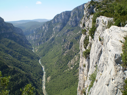
Verdon Gorge (Gorges du Verdon), often called Europe's Grand Canyon, is one of France's most spectacular natural wonders. Located in the Provence-Alpes-Côte d'Azur region (straddling Var and Alpes-de-Haute-Provence departments), it features dramatic limestone cliffs up to 700 meters high, turquoise waters from glacial minerals, and a mix of adventure and scenic beauty.
Best Time to Visit
June to August is prime time: consistent
sunshine, warm weather (ideal for swimming and boating), and open
rentals/activities. However, it gets very crowded, especially mid-July
to mid-August.
Shoulder seasons (May or September) offer fewer crowds
and pleasant temperatures for hiking, though some boat rentals may have
limited hours or close. April–June and September–October suit hiking
best due to milder conditions.
Avoid winter if possible (trails can
be icy or risky due to rockfalls), but the roads and some viewpoints
remain accessible year-round.
How to Get There
By car
(recommended): Essential for flexibility. From Nice: ~1.5–2.5 hours;
from Cannes: ~1.75 hours; from Aix-en-Provence: ~2 hours; from
Marseille: ~2.5 hours. Set GPS to Pont du Galetas for the main access
point at Lac de Sainte-Croix.
Public transport/tours: Limited buses
(e.g., from Nice to Castellane). Organized day tours from Nice, Cannes,
or Marseille are convenient but restrictive for activities.
Gas tip:
Fill up beforehand—stations are scarce in the gorge area.
Top
Ways to Experience the Gorge
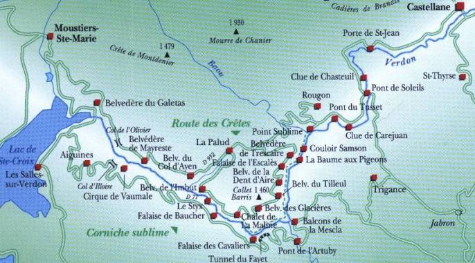
1. Scenic Drives (Route des Crêtes &
More)
Drive the Route des Crêtes (D23) — a ~23 km one-way loop from
La Palud-sur-Verdon with 14+ belvederes (viewpoints) offering
jaw-dropping panoramas. Drive clockwise for best views. Combine with the
north (Route des Gorges) and south banks for a full loop (~130 km
total).
Key viewpoints:
Pont du Galetas — Iconic bridge
overlooking the turquoise entrance to the gorge and boat area.
Point
Sublime (near Rougon) — Breathtaking view of the Samson Corridor.
Balcons de la Mescla, Corniche Sublime, and others along D71/D19.
Tip: Start early to avoid traffic and secure parking. Narrow, winding
roads—drive cautiously.
2. On the Water (Highlight for Most
Visitors)
Rent boats at Pont du Galetas (Lac de Sainte-Croix) to
paddle ~1.5 km into the gorge (further restricted for environmental
protection).
Pedal boats/kayaks/canoes: ~€10–20/hour. Great for
swimming stops.
Electric/motor boats: Better for groups or covering
ground (~€70 for 2 hours).
Other spots: Beaches around the lake
(e.g., Plage de Chabassol for swimming).
Practicalities: Arrive early
(before 10am) or book ahead in peak season. Bring sunscreen, hat, water,
snacks/picnic, and a dry bag. Water shoes recommended (pebbly beaches).
You can swim from boats or beaches.
Advanced options: Rafting,
canyoning, or multi-day canoe descents (best around La Palud-sur-Verdon
or Castellane). Guided for safety.
3. Hiking
Countless trails
suit all levels:
Sentier Blanc-Martel (Martel Trail): Iconic ~14 km
one-way (or sections). Tunnels, ladders, stunning gorge views.
Family-friendly from ~7 years with care.
Imbut Trail and others for
more challenge.
Safety essentials: Good hiking shoes, plenty of
water, windbreaker, headlamp/torch, first-aid kit, detailed map/app.
Check weather (thunderstorms common). Stay on paths—no shortcuts. Never
cross the river casually (dangerous currents).
Guided hikes available
if inexperienced.
4. Other Activities
Rock climbing (Verdon is
legendary), paragliding, electric biking on ridges, cliff jumping (with
caution).
Visit nearby villages: Moustiers-Sainte-Marie (charming,
pottery-famous, great base), La Palud-sur-Verdon, Castellane.
Where to Stay
Moustiers-Sainte-Marie: Picturesque, close to the
action (~10 min to Pont du Galetas). Top choice for charm.
La
Palud-sur-Verdon or Rougon: Closer to upper gorge hikes/viewpoints.
Cotignac or lake villages (e.g., Sainte-Croix-du-Verdon): Relaxed bases
~30–45 min away.
Camping/glamping: Popular in summer near lakes.
How long? 1 full day for highlights (drive + boat); 2–3+ days for
hiking, relaxation, and deeper exploration.
Practical Tips &
Safety
Crowds & timing: Go early. Peak summer is busy—book
boats/accommodations ahead.
What to pack: Sunscreen, hat, swimsuit,
towel, hiking shoes, water (lots), snacks/picnic, binoculars, cash/ID
for rentals, bug spray.
Safety: Respect heights (vertigo warning on
some paths). Watch for rockfalls. Check forecasts. Leave no valuables
visible in car (theft reported at some lots).
Food: Picnic often
best, or try Provençal spots in villages (panoramic terraces
recommended). Markets in Cotignac or Moustiers for supplies.
Accessibility: Some viewpoints/drives ok, but hikes and boats not ideal
for limited mobility.
Environment: Leave no trace. Respect protected
areas.
Geological Formation (Hundreds of Millions of Years Ago)
The
gorge's story begins in deep geological time. During the Triassic period
(around 250–200 million years ago), the Provence region subsided and was
covered by sea, depositing thick layers of limestone. In the Jurassic
period, a warm shallow sea supported coral growth, adding more limestone
deposits. The Cretaceous saw uplift in parts of Provence.
Major
tectonic activity during the Tertiary era (part of the Alpine orogeny)
fractured these limestone deposits, creating relief with valleys. The
Verdon River began adapting its course to these deformations. The
Messinian salinity crisis (~6–5.3 million years ago), when the
Mediterranean dried up dramatically, likely influenced early karst
systems (caves and underground networks) in the limestone.
Intense
erosion accelerated in the Quaternary period (starting ~2.58 million
years ago), driven by glaciation and river action. Glaciers scoured the
landscape, and post-glacial river erosion—combined with the river's high
flow rates (historically up to 2,000–3,000 m³/s during floods)—deeply
carved the limestone plateau. Recent studies using cosmogenic nuclides
suggest the main downcutting of the High Verdon Gorges began around
1.5–2 million years ago, influenced by tectonic/isostatic uplift and
climate cooling.
The result is a dramatic canyon with features like
the Styx du Verdon (a sub-canyon) and the Imbut (where the river
temporarily disappears underground). The river's distinctive color comes
from glacial sources, minerals (like fluorite), and microalgae.
Prehistory and Early Human Occupation
Humans have inhabited the
Verdon area for hundreds of thousands of years. The first settled
populations date back to around 400,000 years ago (or even earlier
traces over 300,000 years). Numerous prehistoric caves along the middle
and lower gorges make this one of France's key prehistoric sites.
Paleolithic and Neolithic eras: Nomadic hunter-gatherers used caves as
shelters. By ~6,000 BCE, Neolithic people became more sedentary,
developing agriculture, animal husbandry, wool spinning, ceramics, and
building dolmens.
Antiquity: The Gaulish Vergunni people inhabited
the valley. Romans incorporated the area into the province of
Narbonensis (~118 BCE) and later the Alpes-Maritimes. Sites like Riez (a
Roman colony) and Castellane (Salinae, known for salt springs)
flourished with villas and agriculture.
Medieval to Early Modern
Periods
The region saw successive influences: Frankish kingdom (from
536 CE), brief independence, Saracen raids (late 9th–10th centuries),
and monastic renewal in the Middle Ages. Feudal restructuring,
Romanesque art, and trade brought prosperity to villages.
The
14th–15th centuries brought crises: economic troubles, the Black Death,
and religious wars. Recovery followed in the 17th–18th centuries with
population growth, village development, and local industries (glassware,
pottery, faience in Moustiers-Sainte-Marie under Louis XIV). The
Enlightenment produced local intellectuals, but the 1720 plague
devastated Provence.
"Discovery" and Exploration (18th–Early 20th
Centuries)
Despite long human presence, the deep gorges remained
largely inaccessible and underappreciated until modern times. Early
printed descriptions appeared in 1782 and 1804; it featured in French
guides by the mid-19th century. Élisée Reclus highlighted it in 1879.
The pivotal moment came in 1905, when geologist and speleologist
Édouard-Alfred Martel (often called the "father of modern speleology")
led the first full documented descent of the gorges, accompanied by
locals including teacher Isidore Blanc. They navigated rapids, cliffs,
and the Imbut. This expedition popularized the term "canyon" for the
site and led to the Blanc-Martel trail (also called Sentier Martel).
Earlier efforts by the Touring Club de France (from 1906) improved
access.
20th Century: Tourism, Infrastructure, and Modern Changes
Tourism grew slowly in the 1920s–1930s with road improvements,
viewpoints (e.g., Point Sublime), and trails. The Route des Crêtes
(Corniche Sublime) offered dramatic views.
Post-WWII hydroelectric
development transformed the area: EDF built five dams (Castillon 1948,
Chaudanne 1952, Sainte-Croix 1974—the largest—and others), creating
artificial lakes like Lac de Sainte-Croix. Some villages were relocated
or submerged. The Parc naturel régional du Verdon was established in
1997 to balance conservation, tourism, and local development.
The
gorge gained fame in rock climbing, especially in the 1980s with
pioneers like Patrick Edlinger. Today, it hosts over 1,500 climbing
routes and attracts hikers, kayakers, rafters, and sightseers.
Vernacular and Medieval Village Architecture
The architecture
around the Verdon Gorge reflects centuries of adaptation to the rugged
limestone terrain, with tight clusters of stone buildings for defense
and climate control. Key examples include:
Moustiers-Sainte-Marie
(often called one of France’s most beautiful villages, at the western
entrance to the gorge):
This perched village clings dramatically to
cliffs. Its narrow, winding cobblestone streets, vaulted passageways,
and stone houses with pink-tiled roofs are quintessential Provençal. The
Église Notre-Dame-de-l’Assomption (12th–14th centuries) mixes Romanesque
and Gothic styles, highlighted by a distinctive Lombard-style bell tower
(one of Europe’s few "moving" or reinforced towers, stabilized in the
17th century with iron keys and beams). The Chapelle Notre-Dame de
Beauvoir (12th century) sits higher up, accessible via 262 steps,
offering panoramic views; it exemplifies early Romanesque simplicity.
Fountains, washhouses (lavoirs), defensive ramparts, and an aqueduct add
to the historic fabric. The village is also renowned for its faïence
(tin-glazed earthenware) tradition, with workshops in historic
buildings.
Castellane (eastern gateway to the gorge):
A medieval
town with remnants of fortifications, including stone gates like the
Porte de l’Horloge (with a belfry and wrought-iron campanile) and Porte
de l’Annonciade. The Église Saint-Victor (12th century) blends
Romanesque and Gothic elements, with a vaulted aisle rebuilt in the 17th
century. The town hall shows neoclassical influences. The Pont du Roc
(early 15th century) is a notable stone bridge spanning the Verdon.
Aiguines:
Overlooks Lake Sainte-Croix with traditional stone houses.
Dominated by the Château d’Aiguines (origins in the 13th century as a
fortified Templar structure, transformed in the early 17th
century/Renaissance period). It features a square plan with round corner
towers topped by glazed tiles from Moustiers, crenellations,
machicolations, and a private chapel. Terraced gardens enhance the site.
Other villages like Bauduen, Esparron-de-Verdon, Rougon, and Annot
showcase similar stone construction, narrow streets, Romanesque churches
(e.g., 16th-century elements in Bauduen), and medieval remnants
integrated into the hilly terrain.
Religious and Defensive
Architecture
Churches and chapels often occupy elevated positions for
both spiritual and defensive reasons:
Romanesque and Gothic
influences dominate, with thick stone walls, vaulted ceilings, and bell
towers suited to the seismic and climatic conditions of Provence.
Perched chapels (like Notre-Dame du Roc in Castellane) provide dramatic
integration with the cliffs.
Engineering and Modern Structures
Human interventions have dramatically shaped the area:
Sainte-Croix
Dam (constructed 1971–1974): A reinforced-concrete arch dam, about 94
meters high. It created the large artificial Lac de Sainte-Croix
(fourth-largest in France), flooding the original village of Les
Salles-sur-Verdon (rebuilt higher up in a more modern style). It serves
hydroelectric power, water supply, and tourism.
Pont du Galetas: A
modern bridge at the gorge’s outlet to the lake, iconic for photographs
and as a boating access point. Built in the 1970s alongside the dam.
Pont de l’Artuby (near Aiguines, 1938–1940): A striking
reinforced-concrete arch bridge (110m main span, 182m height) designed
by Pelnard-Considère et Caquot and built by Thorrand et Cie. It
exemplifies early 20th-century engineering boldness in a dramatic
setting; popular for bungee jumping.
Other historic bridges include
the Pont de Tusset (17th century, stone) and older crossings dating back
to the 11th century in some spots.
Contemporary and Adaptive
Elements
Museum of Prehistory at Quinson: A modern almond-shaped
building designed by Norman Foster, contrasting with the ancient
surroundings.
Many villages feature restored bastides (fortified
houses), troglodyte-inspired elements (e.g., in nearby Cotignac), and
terraced gardens.
Tourism has led to sensitive adaptations like
viewpoints, trails (e.g., Sentier Martel), and eco-friendly
infrastructure that respects the natural and historic character.