Location: South Central France Map
Length: 125 km
Height: 12,316 ft (3,754 m)
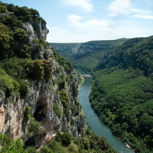
The Ardèche Gorge (Gorges de l'Ardèche) in southern France is one of the country's most spectacular natural wonders, often called the "European Grand Canyon." It is a dramatic limestone canyon carved by the Ardèche River over millions of years, stretching approximately 24–30 km (about 15–19 miles) from near Vallon-Pont-d'Arc to Saint-Martin-d'Ardèche. The gorge features towering cliffs up to 300 meters (nearly 1,000 ft) high, lush Mediterranean vegetation, pebble beaches, rapids, and a rich prehistoric heritage. It was designated a nature reserve (Réserve Naturelle des Gorges de l'Ardèche) in 1980 to protect its unique geology, biodiversity, and archaeological sites.
Geology and Formation
The gorge was formed primarily through
karstic erosion in a limestone plateau. The Ardèche River, originating
in the Cévennes Mountains, gradually cut through the rock over millions
of years, creating meanders, cliffs, and natural arches. Key processes
include chemical dissolution by water, mechanical abrasion by pebbles
and sediment, and collapse of underground caves. The Pont d'Arc itself
formed around 124,000 years ago (during the Pleistocene) when the river
cut off a meander loop.
The landscape includes sheer vertical walls,
grottoes (caves), and varied flora/fauna adapted to the Mediterranean
climate—oak forests, scrubland (garrigue), and species like eagles,
vultures, and otters.
Iconic Landmark: Pont d'Arc
The
undisputed star of the gorge is the Pont d'Arc, a massive natural stone
arch spanning the Ardèche River. It measures about 54–60 meters high and
59–60 meters wide, making it one of the largest and most impressive
natural river arches in the world (and the only major one in France over
an active river).
Formation: The river eroded a meander until it
created a shortcut through the rock.
Significance: It serves as the
symbolic "gateway" to the gorge. A pebble beach below is popular for
swimming, picnicking, and launching canoes/kayaks.
Views: Best seen
from the river (by boat) or nearby viewpoints/parking areas. Early
morning or late afternoon offers golden light and fewer crowds.
Prehistoric and Cave Sites
The gorge is famous for its caves, many
containing evidence of Upper Paleolithic human activity.
Chauvet-Pont-d'Arc Cave (and Chauvet 2 replica): Discovered in 1994, the
original cave (near Pont d'Arc) contains extraordinary
30,000–36,000-year-old paintings—the oldest known figurative art. It is
a UNESCO World Heritage Site. The public visits the exact replica,
Chauvet 2 – Ardèche, which faithfully reproduces the artworks, geology,
and atmosphere. Reservations are essential.
Grotte de la Madeleine:
Located within the gorge, this cave features impressive stalactites,
stalagmites, and illuminated formations. It offers guided tours and is
accessible via paths from the gorge road.
Aven d'Orgnac (Grand Site
de France): A massive underground system nearby (not directly in the
gorge but closely associated) with colossal chambers, towering
stalagmites (some over 10–20m), and exceptional acoustics. It includes a
"Grand Salle" and modern visitor facilities.
Viewpoints and
Scenic Drive
The Route des Gorges (D290) is a stunning panoramic road
along the rim, with numerous belvederes (viewpoints) offering
breathtaking overlooks. Highlights include:
Belvédère du Serre de
Tourre: Views of meanders.
Belvédère de la Madeleine: Dramatic narrow
passages.
Belvédère des Templiers and others resembling Utah canyons.
Cirque d'Estre and Cathedral viewpoints for vertical walls.
The drive
is especially beautiful in spring (wildflowers) or autumn (colors).
Activities and Exploration
Canoeing/Kayaking: The most popular
way to experience the gorge—full or half-day trips (with ~26 rapids).
Many start near Pont d'Arc. Bivouac (overnight camping) sites are
available in the reserve.
Hiking: Trails like the Grotte du Parapluie
loop or rim paths offer moderate-to-challenging hikes with views and
swimming spots.
Climbing and Swimming: Excellent limestone routes and
river beaches.
Nearby Villages: Vallon-Pont-d'Arc (gateway town),
Aiguèze, Ruoms, and medieval sites like Balazuc.
Practical Tips
Best Time: Late spring to early autumn for water activities; avoid peak
summer crowds if possible.
Access: Easy from Vallon-Pont-d'Arc. The
reserve has restrictions (e.g., no private cars in some sections).
Conservation: Stick to trails, respect wildlife, and follow fire/bivouac
rules.
The Ardèche Gorge (Gorges de l'Ardèche), a stunning 30-kilometer
(19-mile) canyon in southern France, is accessible via various
transportation modes, making it a popular destination for nature lovers
and adventurers. Located in the Ardèche department of the
Auvergne-Rhône-Alpes region, the gorge starts at Vallon-Pont-d'Arc (home
to the iconic Pont d'Arc natural arch) and ends at
Saint-Martin-d'Ardèche. Reaching it typically involves traveling to
nearby towns like Vallon-Pont-d'Arc or Ruoms, from where you can explore
by car, canoe, or on foot. The area is well-connected by road, rail, and
air, with major hubs including Lyon (about 2 hours north), Marseille
(2-3 hours south), and Paris (5-7 hours north). As of November 2025,
transportation options remain reliable, though summer crowds can cause
delays—book in advance for rentals or tours. Below is a detailed guide
on how to get there, covering multiple starting points and tips for a
smooth journey.
By Car
Driving is the most flexible and
popular way to reach and explore the Ardèche Gorge, allowing stops at
scenic viewpoints along the D290 road (Route des Gorges), which runs
parallel to the river for about 29 kilometers (18 miles) with 11
designated overlooks. The area is accessible via the A7 motorway
(Autoroute du Soleil), exiting at Montélimar-Nord (exit 18) or Bollène
(exit 19), then following the D994 or D86 toward Vallon-Pont-d'Arc. From
there, the gorge entrance is just a short drive east. Expect tolls on
the A7 (around €20-30 from Lyon or Marseille), and note that the D290 is
winding and narrow in spots—drive cautiously, especially in summer when
RVs and tour buses are common.
From Paris (approx. 600 km/373
miles, 6-7 hours): Take the A6 south toward Lyon, then merge onto the
A7. This route offers rest stops and scenic views through Burgundy and
the Rhône Valley. Fuel costs average €80-100 one-way, depending on
vehicle efficiency.
From Lyon (approx. 200 km/124 miles, 2-3 hours):
Head south on the A7, exiting at Montélimar-Nord. This is a
straightforward drive through vineyard country.
From Marseille
(approx. 220 km/137 miles, 2.5-3.5 hours): Take the A7 north, exiting at
Bollène. The route passes through Provence landscapes, with options for
detours to Avignon.
Tips: Rent a car from major airports (e.g.,
Lyon-Saint-Exupéry or Marseille-Provence) for €30-50/day. Parking is
available in Vallon-Pont-d'Arc (free lots or paid garages at €5-10/day).
Electric vehicle charging stations are increasing, but plan ahead for
rural areas. Avoid peak summer weekends due to traffic.
By Train
France's efficient rail network provides convenient access, though the
gorge itself lacks direct stations—plan for a transfer to bus or taxi
from nearby hubs. High-speed TGV trains connect major cities to
Montélimar, Pierrelatte, or Valence, from where local transport leads to
the gorge.
From Paris (4-5 hours total): Take a TGV from Gare de
Lyon to Montélimar (2.5-3 hours, €50-120), then a bus or taxi (45
minutes, €10-30) to Vallon-Pont-d'Arc. Direct connections via
Eurostar/Thalys for international travelers.
From Lyon (1.5-2.5
hours): TGV or regional TER trains to Montélimar or Valence (1 hour,
€20-50), followed by a bus transfer.
From Marseille (2-3 hours): TGV
to Avignon or Montélimar (1-1.5 hours, €30-70), then bus/taxi.
Tips:
Book tickets via SNCF Connect app or website for discounts (e.g.,
youth/senior passes). Trains run frequently, but rural connections are
limited—check schedules. For eco-friendly travel, trains emit less CO2
than cars.
By Bus
Buses offer budget-friendly options,
especially for those without cars, connecting from regional cities via
operators like FlixBus, Blablabus, or local Ardèche lines.
From
Paris (7-9 hours): Direct buses to Montélimar or Aubenas (€40-60), then
local bus to Vallon-Pont-d'Arc (1 hour, €5-10).
From Lyon (3-4
hours): Buses to Montélimar (€15-30), with transfers.
From Marseille
(3-4 hours): Direct to Montélimar (€20-40).
Tips: Use apps like
Rome2Rio for routes. Local buses (e.g., line A15 from Montélimar) run
seasonally—confirm via ardeche.fr. Comfort varies; opt for
air-conditioned coaches in summer.
By Plane
Flying is ideal
for international visitors, with several nearby airports offering car
rentals or shuttles.
Major Airports:
Lyon-Saint-Exupéry (LYS,
2 hours drive): Direct flights from Europe/USA; rent a car (€30-50/day)
or bus/train combo.
Marseille-Provence (MRS, 2.5 hours): Budget
flights; similar transfers.
Nîmes (FNI) or Avignon (AVN, 1-1.5
hours): Smaller, with seasonal flights from UK/Europe.
From Paris
Airports (CDG/ORY): Fly to Lyon or Marseille (1 hour, €50-150), then
drive/bus.
Tips: Use shuttles from airports (e.g., Rhône Express from
LYS, €15). For groups, private transfers cost €200-300 from Lyon.
Practical Tips and Considerations
Best Time: Spring (April-June)
for mild weather and fewer crowds; avoid mid-summer heat (up to
35°C/95°F) and flash floods.
Costs: Budget €100-200 for transport
from major cities, plus €20-50 for canoe rentals.
Accessibility: The
gorge is rugged; wheelchair access is limited to viewpoints. Eco-tours
available for all abilities.
Sustainability: Follow Leave No Trace
principles; use public transport to reduce emissions.
Resources:
Check rome2rio.com for routes, sncf.com for trains, and
ardeche-guide.com for local info.
Best Time to Visit
Ideal periods: May–June and September. These
months offer pleasant temperatures (warm but not extreme), fewer crowds,
good water levels for paddling, and comfortable hiking conditions.
Peak summer (July–August): Lively with events and full services, but
very hot (often 30°C+), crowded on the river and at viewpoints, and
busier roads/parking.
Shoulder/Off-season: April and October can work
for milder crowds and lower prices, though water may be cooler and some
services limited. Winter is quiet but cold and less suited for water
activities.
Accommodation Tips
Camping: Very popular—riverside
sites near Vallon or in the gorge (book early for summer). Luxury
glamping options like Prehistoric Lodge exist.
Hotels/Gîtes: In
Vallon-Pont-d’Arc, Saint-Martin, or villages like Aiguèze. Self-catering
gîtes suit longer stays.
Bivouac: Strictly regulated—only at two
managed sites in the reserve. No wild camping.
Practical Visiting
Tips
What to Bring: High-SPF sunscreen (limestone reflects
intensely), hat, reusable water bottle, sturdy shoes for hikes,
quick-dry clothes, snacks/picnic supplies. For paddling: old
sneakers/water sandals (no loose laces), waterproof phone case.
Safety:
River levels vary—check conditions. Rapids can be tricky for
beginners; go with guides if unsure.
Stay on trails at viewpoints
(cliffs are dangerous).
Heat exhaustion in summer; carry plenty of
water.
Drive cautiously on gorge roads.
Costs: Canoe rental
~€20–50/person depending on route/duration. Entry to sites low or free;
meals affordable in villages.
Crowds & Etiquette: River gets busy on
weekends/summer—start early or late. Respect the nature reserve: no
littering, stick to paths.
Food & Drink: Try local Ardèche
products—chestnuts, wines, charcuterie, and caillettes (meat patties).
Night markets in summer.
Nearby & Extending Your Trip
Combine
with:
Beautiful villages like Aiguèze or Ruoms.
Other caves or the
Vivarais region.
Proximity to Provence (lavender, Avignon) or the
Rhône Valley.
Duration Recommendation: 2–4 days minimum for a good
mix of paddling, driving, and relaxing. A full gorge descent is
unforgettable.
Location and Dimensions
The gorge lies primarily in the
Ardèche department (Auvergne-Rhône-Alpes region), with its lower
section forming the boundary between Ardèche and Gard
departments. It stretches approximately 30 km (19 miles) from
Vallon-Pont-d'Arc (upstream entrance, famous for the natural
Pont d'Arc arch) to Saint-Martin-d'Ardèche (downstream exit),
where the river joins the Rhône.
Depth: Up to 300 meters
(about 1,000 feet) in places.
Cliffs: Steep, often vertical
limestone walls.
Area: The core zone is a 1,575-hectare
nature reserve established in 1980.
The surrounding
region is part of the eastern edge of the Massif Central,
transitioning from higher plateaus to the Rhône Valley lowlands.
The gorge cuts through a limestone plateau in the Bas-Vivarais
area, creating a rugged, incised landscape amid more open
Mediterranean-influenced terrain.
Geological Formation
and Features
The gorge formed over millions of years through
a combination of sedimentation, uplift, and erosion:
Sedimentation: In ancient times, the area was covered by a warm
shallow sea. Marine deposits accumulated, forming thick layers
of limestone (primarily Urgonian limestone).
Uplift: Tectonic
forces, linked to the formation of the Alps and Massif Central,
raised these sediments into a plateau.
River Incision: The
Ardèche River, flowing southeastward, gradually eroded downward
through the limestone via mechanical abrasion, chemical
dissolution (karst processes), and seasonal floods. This created
the deep, winding canyon.
Key rates and history:
Significant incision occurred during the Pleistocene (last ~2.6
million years), with river downcutting influenced by climate
cycles (glaciations and interglacials), base-level changes, and
moderate tectonic uplift of the Massif Central. Mean incision
rates in the Middle-Late Pleistocene are estimated around 76 ± 7
meters per million years.
Notable formations:
Pont
d'Arc: A massive natural stone arch (54 m high, 60 m wide)
spanning the river, formed ~124,000 years ago when the river
breached a meander loop. It serves as the iconic "gateway" to
the gorge.
Vertical cliffs, overhangs, caves, and potholes.
Dramatic bends, rapids, and features like "the Cathedral" (a
striking rock formation).
Extensive karst landscape with
numerous caves (e.g., Chauvet-Pont-d'Arc Cave, a UNESCO site
with ~36,000-year-old paintings).
The river itself is ~78
miles (125 km) long overall but transforms dramatically in the
gorge section, with calmer pools and faster sections with
mini-rapids.
Topography and Hydrology
The gorge
features a classic canyon morphology: narrow floor with the
river, flanked by towering walls and a plateau above. The
plateau has forested crests, scrubland, and garrigue vegetation.
The river's course is sinuous, creating meanders and steep
drops.
Climate: Mediterranean influence in the
lower/southern parts — warm, dry summers and mild winters, with
hot days and cooler nights. Higher elevations see more
continental traits with greater temperature swings, occasional
snow, and heavy autumn rains. The Mistral wind can be strong.
Water dynamics: Subject to flash floods; the river can rise
rapidly after heavy rains, sculpting the landscape. Clear,
turquoise waters in normal flow.
Geological Formation (Millions of Years Ago)
The gorge's
story begins millions of years ago when the region lay under a
vast ocean. Marine sediments formed thick limestone plateaus.
Tectonic uplift, river erosion, and climatic cycles (including
glaciations) shaped the landscape over time. The Ardèche River
exploited faults in the limestone, gradually incising a deep
canyon through meanders and erosion processes.
The iconic
Pont d'Arc—a natural limestone arch about 54–66 m high and 34–60
m wide—is a key feature. It formed when the river cut through a
meander loop (likely between 108,000 and 138,000 years ago, or
at least 500,000 years old by some estimates), creating a
shortcut and leaving the arch as a gateway to the gorge.
This
karst landscape produced thousands of caves and rock shelters,
which later became crucial for human habitation and art
preservation.
Prehistoric Era (Upper Paleolithic and
Earlier)
Humans have inhabited the area for over 300,000
years, with evidence in caves and rock shelters. The gorge is
world-famous for its Upper Paleolithic sites, especially from
the Aurignacian period (around 37,000–28,000 years ago).
The
standout is the Chauvet-Pont d'Arc Cave (Grotte Chauvet),
discovered in December 1994 by speleologists Jean-Marie Chauvet,
Éliette Brunel Deschamps, and Christian Hillaire. Located above
the former riverbed near Pont d'Arc, it contains some of the
oldest and best-preserved figurative cave art in the world—over
400 animal paintings and engravings (lions, rhinos, mammoths,
horses, bears, etc.) using advanced techniques like shading,
perspective, and scraping walls for contrast.
Radiocarbon
dating places most artwork in two main phases: ~37,000–33,500
years ago and ~31,000–28,000 years ago.
The cave was sealed
by rockfalls ~20,000–23,000 years ago, preserving it pristinely
until modern discovery.
It was designated a UNESCO World
Heritage Site in 2014. The original is closed to the public to
prevent damage (as happened at Lascaux); a full-scale replica,
Caverne du Pont d'Arc (Chauvet 2), opened in 2015.
Other
sites include engravings in caves like Chabot, Deux-Ouvertures,
and Points, plus ~800 dolmens and menhirs on the plateau from
the Neolithic period (~5,000 BC onward). Artifacts like flint
tools and arrowheads are common.
The gorge provided shelter,
resources, and possibly ritual significance for early modern
humans in Europe.
Ancient History (Gauls, Romans, and
After)
The area was home to the Gaulish Helvii tribe, part of
Gallia Narbonensis. Their capital shifted from Alba-la-Romaine
(Alba Helviorum) to Viviers. Roman influence brought
infrastructure, though the rugged gorge itself remained more
peripheral. Saint Andéol is traditionally credited with
evangelizing the region in the early 3rd century.
Medieval Period (9th–15th Centuries)
The Vivarais (historical
name for the Ardèche region) suffered depopulation from
9th-century raids by Hungarians and Saracen slavers. Recovery in
the 10th–11th centuries saw Romanesque churches built.
In the
12th century, the gorge's remoteness made it a refuge. The
Knights Templar reportedly built a maladrerie (leper hospital or
plague hospital) in the Cirque de la Madeleine for Crusaders
returning with diseases. Ruins remain today.
The region was
contested: held by Counts of Toulouse, then the French crown
(1229 onward), and influenced by bishops of Viviers. It featured
feudal castles, keeps, and perched medieval villages (e.g.,
Balazuc, Vogüé) that still characterize the area. During the
Hundred Years' War, it largely stayed loyal to the French crown
despite raids.
Early Modern Period (16th–18th Centuries)
The Ardèche became a Protestant stronghold during the
Reformation, influenced by nearby Geneva and Lyon. It saw heavy
fighting in the Wars of Religion (1562–1598), with battles,
sieges (e.g., Privas burned in 1629), and emigration after the
Revocation of the Edict of Nantes (1685). The Camisard Revolt
followed, with brutal "dragonnades" by royal forces.
Economically, silk (mulberry trees), tobacco, and agriculture
developed, alongside figures like Olivier de Serres (pioneer of
modern French farming) and the Montgolfier brothers (hot air
balloon inventors from Annonay, 1783).
19th–20th
Centuries: Revolution to Modernity
The French Revolution
brought rights for Protestants but also the Reign of Terror. The
department of Ardèche was created in 1790. The 19th century saw
modest growth in silk and mining, followed by decline due to
disease (silkworms, phylloxera) and competition. Population
peaked mid-century then declined as people migrated to cities.
The gorge remained relatively isolated until roads improved in
the 20th century.
Modern Tourism and Conservation
(Mid-20th Century Onward)
Tourism boomed after World War II.
A road along the gorge (D290) opened access to viewpoints.
Canoeing/kayaking down the river (popular since the late 20th
century) became iconic, with Pont d'Arc as the starting point.
The area draws over a million visitors yearly.
Key
milestones:
1980: Designated a Nature Reserve for
biodiversity protection (over 1,000 plant/animal species).
1994: Chauvet Cave discovery.
2015: Chauvet 2 replica opens.
Ongoing: Hiking trails, viewpoints, and sustainable tourism
efforts balance access with preservation.
The Ardèche Gorge (Gorges de l'Ardèche) in southeastern France
is a spectacular limestone canyon carved by the Ardèche River
over millions of years. It stretches about 30 km between
Vallon-Pont-d'Arc and Saint-Martin-d'Ardèche, forming part of a
designated Réserve Naturelle Nationale (National Nature Reserve)
covering around 1,575 hectares.
This Mediterranean-influenced
landscape—characterized by steep cliffs (up to 300 meters high),
caves, rocky plateaus, riverbanks, oak forests, and scrubland
(garrigue)—supports exceptional biodiversity. The reserve is
often cited as hosting over 1,000 plant species and hundreds of
animal species (with estimates of around 200 vertebrates or more
in some counts), making it a hotspot for botanists,
birdwatchers, and nature enthusiasts.
The climate is
Mediterranean: hot, dry summers and mild, wetter winters, with
limestone soils favoring drought-resistant and calcicole
(lime-loving) species.
Flora (Vegetation)
The gorge
features a mosaic of habitats: riverine forests, cliffs and
rocky outcrops, Mediterranean garrigue/scrub, and woodlands.
Vegetation is adapted to rocky, calcareous (limestone)
substrates, steep slopes, sun exposure, and periodic flooding or
drought.
Key plant communities and species include:
Mediterranean scrub and woodlands (garrigue and holm oak
forests): Dominant on plateaus and slopes. Holm oak (Quercus
ilex), a tough evergreen, forms dense stands. Other common
elements: boxwood (Buxus sempervirens), junipers (several
species), wild olives, lavender, thyme, savory, and aromatic
herbs typical of Provence.
Cliff and rock-face specialists:
Rare and protected species thrive in crevices and ledges,
including gorge sandwort (a localized endemic or rare plant),
rockroses (Sedum species and Cistus), and various saxifrages or
stonecrops adapted to minimal soil.
Riverbanks and riparian
zones: Alder (Alnus), ash (Fraxinus excelsior), willows (Salix),
poplars, and invasive or naturalized species like Impatiens
(balsams). Wild fig trees and other moisture-loving plants
appear near the water.
Notable or protected plants: Wild
orchids (numerous species), Helichrysum italicum (curry plant),
Teucrium species (germanders), Cistus salviifolius, and
bryophytes (mosses and liverworts—over 216 taxa recorded, making
it a bryological hotspot).
Other highlights: Pine species
(including rarer ones like Salzmann's pine in broader Ardèche
areas), vines, and spring wildflowers such as anemones, violets,
and daffodils on higher or varied terrains.
The flora
transitions from more temperate influences in shaded or higher
areas to classic Mediterranean drought-resistant plants on
exposed south-facing slopes.
Fauna
The gorge's varied
topography—cliffs for nesting, river for aquatic life, forests
and scrub for cover—supports rich wildlife. Many species are
protected, and the area is important for raptors and
reintroduced or recovering mammals.
Birds (Avifauna): One
of the standout groups, especially on cliffs.
Raptors:
Bonelli's Eagle (Aquila fasciata)—very rare in France, with only
a couple of pairs in the southern Ardèche (one of the key sites
nationally). Peregrine Falcon (Falco peregrinus), Short-toed
Snake Eagle (Circaetus gallicus), Egyptian Vulture (Neophron
percnopterus), Griffon Vulture, and others like kestrels.
Other birds: Crag Martin (Ptyonoprogne rupestris—very common on
cliffs), jackdaws, sand martins, various owls, woodpeckers, and
passerines. The area supports significant bird diversity
overall.
Mammals:
Semi-aquatic: European Beaver
(Castor fiber)—well-established along the river, playing a key
ecological role in habitat modification. Otters are also
present.
Others: Wild boar, deer (roe and red in surrounding
areas), bats (colonies in caves), and semi-wild goats that roam
the cliffs and roads (descendants of former domestic herds, now
a charismatic feature).
Broader Ardèche supports around 75
mammal species in regional parks, including smaller rodents and
predators.
Reptiles and Amphibians:
Green lizards,
ocellated/jewelled lizards, grass snakes, viperine snakes,
Aesculapian snakes, palmate newts, spotted salamanders, and
others. The warm, rocky environment is ideal for sun-basking
reptiles.
Aquatic life: Brown trout, other fish, dragonflies,
and diverse aquatic insects in the river and side streams. The
clear waters support healthy invertebrate populations.
Insects and others: High diversity, including butterflies and
many pollinators benefiting from the floral richness.
Designated a Natural Reserve in 1980, the gorge is protected under French environmental laws, prohibiting hunting, mining, and excessive development to safeguard its biodiversity. Management by the Syndicat de Gestion des Gorges de l'Ardèche focuses on erosion control, water quality monitoring, and invasive species removal, while promoting sustainable tourism through visitor caps and eco-education. Challenges include overtourism (e.g., litter and erosion from hikers) and climate change impacts like droughts affecting river levels, addressed via reforestation and habitat restoration projects. As part of larger networks like the Parc Naturel Régional des Monts d'Ardèche, it serves as a model for balancing recreation with preservation in fragile canyons.