Location: Lozère and Gard départements Map
Area: 913 km²
Official site
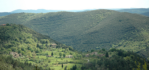
Cévennes National Park (Parc national des Cévennes) is a vast protected area in southern France, renowned for its rugged mountainous landscapes, rich biodiversity, and unique blend of natural and human heritage. Established in 1970, it stands out as the only French national park with a permanently inhabited core, encompassing around 250 villages and supporting traditional agropastoral lifestyles. Covering approximately 938 square kilometers in its core zone and extending to over 3,000 square kilometers including the buffer area, it is one of the largest national parks in metropolitan France. The park is a UNESCO Biosphere Reserve since 1985 and part of the UNESCO World Heritage-listed "Causses and Cévennes, Mediterranean agro-pastoral Cultural Landscape" since 2011, highlighting its role in preserving both ecological and cultural values.
Cévennes National Park (Parc national des Cévennes) is located in
southern France's Massif Central, spanning parts of the Lozère, Gard,
Ardèche, and Aveyron departments in the Occitanie region. It's a UNESCO
World Heritage Site known for its diverse landscapes, including
mountains, rivers, and forests. The park covers a large area (about 938
square kilometers in the core zone), so access depends on your starting
point and which section you want to visit—key entry towns include Florac
(park headquarters), Alès, Mende, and Millau. The best way to explore is
by car due to the rural, winding roads, but public options exist.
By Car
Driving is the most flexible and recommended method, as
public transport is limited within the park. Access via major highways:
From the north (e.g., Paris or Clermont-Ferrand): Take the A75
autoroute south toward Millau or Mende.
From the south (e.g.,
Montpellier or Nîmes): Use the A9 or A7 autoroutes, then connect to
regional roads like the D907 or D986 toward towns such as Alès or
Florac.
From the east (e.g., Marseille): A7 north to connect with the
A9, then head northwest.
Key roads inside the park: D907B (near Mont
Aigoual), D986 (through the Bougès area), and N106 (to Mont Lozère). You
can drive close to summits like Mont Lozère (via Le Bleymard) or Mont
Aigoual.
Roads are narrow, curvy, and mountainous—allow extra
time (e.g., measure in hours, not kilometers) and check for closures in
winter. Rent a car in nearby cities like Montpellier or Nîmes for
convenience.
By Plane
Fly into one of these nearby airports,
then continue by bus, train, or rental car:
Nîmes-Alès-Camargue-Cévennes (FNI): Closest small airport, about 1-2
hours drive to the park's southern edges. Direct access via regional
buses or taxis to Alès.
Montpellier (MPL): 1.5-2.5 hours away. From
here, take a bus to Val-d'Aigoual or La Serreyrede via Montpellier city
center, or rent a car.
Marseille (MRS): Around 2-3 hours drive; the
nearest major international airport. Bus or train connections to Nîmes
or Alès.
Other options: Rodez (RDZ) or Béziers (BZR) for northern
access, about 1.5-2 hours.
Major cities like Montpellier,
Toulouse, and Marseille serve as good hubs for flights and onward
travel.
By Train
High-speed TGV trains connect to gateway
cities, followed by regional TER lines:
From Paris: TGV to Nîmes
(about 3 hours), then TER to Alès (30-45 minutes).
From other cities:
TGV to Montpellier or Marseille, then local trains to Alès or Mende.
Inside the region: Trains run to Alès (southern access) or La
Bastide-St-Laurent (northern), with connections to buses for deeper park
entry. Note that train service to interior towns like Florac is
sparse—check SNCF schedules.
By Bus or Public Transport
Public
options are available but infrequent, especially in rural areas—plan
ahead and combine with hiking or taxis for last-mile access.
From
Alès or Mende: Regional buses (e.g., LiO network in Occitanie) to Florac
or other villages.
From Montpellier: Buses to Val-d'Aigoual or other
park entry points.
Shuttles: Seasonal shuttles may operate in summer
for popular trails; check local tourism sites.
Tips
The park
is best visited from spring to fall (April-October) for milder weather
and open roads—avoid winter due to snow.
Use apps like Rome2Rio or
Google Maps for real-time routes, but verify with official sources as
rural coverage can vary.
For eco-friendly travel, consider
trains/buses to minimize car use in this protected biosphere reserve.
If focusing on specific areas like the Gorges du Tarn or Mont Aigoual,
enter via Sainte-Enimie or Meyrueis.
Situated in the southern part of the Massif Central, the park primarily spans the departments of Lozère and Gard, with extensions into Ardèche. It features mid-mountain terrain with elevations ranging from 378 meters to 1,699 meters at Mont Lozère, the highest point. The landscape is diverse, including limestone plateaus (causses) like the Causse Méjean, deep gorges carved by rivers such as the Tarn and Jonte, schist valleys, granite massifs, and Mediterranean hillsides. Rivers and streams crisscross the area, creating waterfalls, canyons, and lush valleys that support varied ecosystems from dense forests to open grasslands. The park's geology reflects ancient processes, with karst formations, cliffs, and caves adding to its dramatic scenery.
The Cévennes region has been shaped by human activity for millennia, from prehistoric settlements to Roman influences and medieval agriculture. It gained historical prominence during the 16th-18th centuries as a stronghold for French Protestants (Huguenots), who faced persecution and rebelled in the Camisard Wars, leaving a legacy of resilient communities and stone-terraced landscapes. The park was officially created on September 2, 1970, with its administrative headquarters at Florac Castle in Lozère, to protect the area's natural and cultural assets amid growing environmental concerns. Unlike many national parks that exclude human presence, Cévennes was designed to integrate local inhabitants, promoting sustainable land use while conserving biodiversity. This innovative approach has influenced global conservation models.
Cévennes is a biodiversity hotspot, hosting over 2,500 plant species,
which represent about half of France's floral diversity. The flora
varies by altitude and climate: Mediterranean zones feature evergreen
oaks, chestnuts, and aromatic herbs like thyme and lavender; higher
elevations have beech, fir, and pine forests, while open meadows bloom
with orchids and wildflowers in spring. Rare endemics include the
Cévennes violet and various carnivorous plants in peat bogs.
The
fauna is equally impressive, with over 2,400 animal species recorded.
Mammals include red deer, roe deer, wild boars, otters, and reintroduced
beavers. Birdlife thrives with golden eagles, peregrine falcons, griffon
vultures (successfully reintroduced in the 1980s), and rare species like
the short-toed snake eagle. Reptiles and amphibians, such as the
Montpellier snake and fire salamander, inhabit the rivers and forests,
while insects like the Apollo butterfly add to the ecological richness.
The park's diverse habitats support this abundance, making it a key site
for wildlife observation.
The park's cultural significance lies in its living heritage, where traditional practices like sheep transhumance (seasonal herding) and chestnut cultivation continue. Stone-built hamlets, terraced fields, and ancient paths reflect centuries of human adaptation to the harsh terrain. The region is dotted with historical sites, including megalithic monuments, Roman ruins, and Protestant temples. Festivals and museums, such as the Ecomuseum of the Cévennes, preserve stories of silk production (once a major industry) and the Huguenot resistance. This integration of culture and nature earned it UNESCO recognition for its agro-pastoral landscape.
Visitors can explore over 5,000 kilometers of marked trails for hiking, mountain biking, or horseback riding, with routes like the Stevenson Trail (inspired by Robert Louis Stevenson's 1878 journey) being particularly popular. Water-based activities include canoeing or kayaking on the Tarn and Chassezac rivers, while rock climbing, caving, and paragliding appeal to adventurers. Wildlife safaris, stargazing (thanks to low light pollution), and guided tours on ecology or history are offered year-round. In summer, free ranger-led events provide insights into the park's secrets. Eco-friendly accommodations, from campsites to gîtes, support sustainable tourism.
As a UNESCO Biosphere Reserve, the park focuses on balancing conservation with human development. Efforts include reforestation, species reintroduction (e.g., vultures and beavers), and habitat restoration to combat climate change impacts like droughts and wildfires. Local communities participate in sustainable farming and tourism initiatives to reduce environmental pressure. Recent developments as of 2025 emphasize biodiversity monitoring and eco-education programs to address ongoing challenges like invasive species and habitat fragmentation. The park's model promotes "living in harmony with nature," serving as a blueprint for protected areas worldwide.