Location: Lembach in the Bas- Rhine department Map
Château de Frœnsbourg (also spelled Frœnsbourg, Froensbourg, or Frundsberg in German) is a striking semi-troglodytic ruined castle in the Northern Vosges mountains of Alsace, France. It sits on a narrow, isolated sandstone spur rising about 40 meters above the Steinbach valley, northwest of Lembach (near Niedersteinbach and the Ferme du Froensbourg) in the Bas-Rhin department. Classified as a monument historique since 1898, the castle blends natural rock formations with medieval construction: caves and rock-cut chambers serve as rooms, cisterns, stairs, and passages, while upper structures (mostly wooden or half-timbered originally) were anchored into the cliff. Today, only evocative ruins remain—accessible via hiking trails (marked blue rectangle from the farm parking area, about 30 minutes' walk)—though safety concerns (degraded stairs) have led to occasional access restrictions.
Situated in the Bas-Rhin department of the Grand Est region (formerly Alsace), the château lies northwest of the town of Lembach, near the village of Niedersteinbach. Its precise coordinates are approximately 49°02'13"N 7°44'35"E. The site is perched on an isolated sandstone spur in the forested hills of the Northern Vosges, oriented north-south and separated from the surrounding mountain by a large artificial ditch. Access is via hiking trails, such as the GR53 long-distance path or trails marked by the Club Vosgien (a blue rectangle symbol), starting from points like the Fleckenstein pond or the Froensbourg farm along the D3 road. The walk to the castle typically takes about 20 minutes on an easy forest path, followed by a steeper climb to the ruins themselves.
13th-Century Origins and Construction
The castle
dates to the 13th century, emerging alongside the noble family de
Froensbourg (or Frundsperg). An indirect reference appears around 1235
with a mention of Eberhard von Frundesberg near the powerful
Fleckenstein castle. It receives its first clear attestation in 1269,
linked to brothers “of Frundsperg.” Historians widely view the
Froensbourg lords as a cadet (younger) branch of the influential
Fleckenstein family, with whom they shared armorial bearings and close
ties, though direct proof of the branch relationship remains elusive.
Builders chose a dramatic defensive site: a north-south oriented
sandstone spur separated from the main ridge by a deep artificial ditch.
The spur naturally splits into two main rocks—a larger, higher northern
one and a smaller southern one—connected mid-height in modern times by a
footbridge. The design is classic for Vosges Felsenburgen (rock
castles): lower levels exploit natural caves for stables, storerooms,
and cisterns; rock-cut stairs and passages provide vertical circulation;
and upper platforms supported keeps, living quarters, and defenses. A
hoisting wheel (mentioned in sources) aided in lifting supplies to the
higher levels. The northern rock hosted the main defensive core
(including a later pentagonal keep), while the southern featured
residential elements.
14th Century: Division, Robber Knights, and
Destruction
Until the 1340s, the Froensbourgs held the castle
exclusively. It then fragmented among multiple co-owners: the
Froensbourgs retained roughly half, while shares went to the lords of
Loewenstein and Sickingen (among others). This period marked the
castle’s notorious phase as a “den of robber knights”
(chevaliers-brigands). Feudal fragmentation in the Holy Roman Empire
enabled such strongholds to serve as bases for raiding and ransoming
travelers or prisoners along regional routes.
In 1348–1349, the
castle’s bandit activities provoked a major response. Reinhard von
Sickingen, one co-owner, epitomized the robber-knight problem. A
coalition known as the Landfriedensbund (Alliance for Public Peace or
League of the Public Weal)—comprising cities, bishops, and
nobles—besieged and largely destroyed the castle. Jean de Lichtenberg
(soon to become Bishop of Strasbourg) played a leading role. A 1349
transaction compensated Siegfried de Loewenstein with 500 florins for
damage to his share while preserving his inheritance rights. Emperor
Charles IV issued a 1354 ban on reconstruction to curb such lawless
fortresses.
Sources differ slightly on immediate aftermath: some
indicate a brief restoration around 1358, when the site was offered (or
pledged) as a palatine fief to Count Palatine Rupert I (Robert the
Elder). However, it faced further destruction shortly afterward,
possibly in 1359 by forces linked to the Bishop of Strasbourg. The
imperial prohibition remained in effect for decades.
Late
14th–15th Century: Rebuilding and Fleckenstein Restoration
The ban
lifted in 1389 under Count Palatine Robert the Old. Brothers Emich and
Sygfrid (Siegfried) de Loewenstein rebuilt the castle and formally
dedicated it as a palatine fief (oblation to the Count Palatine),
integrating it into the broader Palatinate sphere.
By the late 15th
century, ownership shifted again. In 1481 (with works dated 1484–1485),
the Fleckenstein family acquired or regained a significant share and
carried out substantial restorations. They constructed or rebuilt a
residential (dwelling) tower on the southern rock, featuring a fine
Gothic ogival arched doorway still visible today and bearing the
construction date. Other late-medieval adaptations included converting
the northern pentagonal keep area into an artillery terrace with gun
embrasures, reflecting the shift toward firearms. Rock-cut
features—kitchens (with a possible early-16th-century dragon engraving
near a hearth), latrines, cisterns, and multi-level chambers—date from
or were enhanced in this era. The castle likely operated with at least
three stories in places: stone bases below, half-timbered upper levels
anchored by grooves in the rock.
16th–17th Centuries: Abandonment
and Final Demolition
The castle appears to have declined and been
largely abandoned by the 16th century amid changing warfare and regional
power shifts. After France’s annexation of Alsace (formalized by the
1648 Treaty of Westphalia and consolidated in subsequent decades), royal
policy targeted private fortresses near the new borders to prevent their
use against the crown. In 1677, French troops under cavalry general
Joseph de Montclar systematically dismantled Frœnsbourg—along with many
other Alsatian castles—rendering it militarily useless. By then, it had
probably stood empty for years.
Legacy and Modern Era
No major
reconstruction followed. The ruins weathered into the forested
landscape, becoming a picturesque hiking destination within the Parc
naturel régional des Vosges du Nord and along the GR53 long-distance
trail. Detailed archaeological and architectural studies, notably André
Lerch’s comprehensive 2012 monograph in the Châteaux-forts d’Europe
journal (issues 60–62), have clarified its complex phasing, rock-cutting
techniques, and integration of natural geology.
The site’s
troglodytic elements—rock-hewn halls, filtered cisterns, zigzag
staircases, and beam-anchor holes—remain its most fascinating features,
offering insight into medieval engineering in the sandstone Vosges.
Though modest in scale compared to nearby giants like Fleckenstein or
Wasenbourg, Frœnsbourg exemplifies the turbulent history of Alsace: a
frontier zone of imperial fragmentation, feuds, banditry, and eventual
French centralization.
Today, it stands as a quiet monument to
medieval lordship, best appreciated on foot through the surrounding
woods, with panoramic views over the Steinbach valley from its rocky
terraces. Note that due to ongoing erosion and safety issues (e.g.,
unstable staircases), visitors should check local advisories before
ascending.
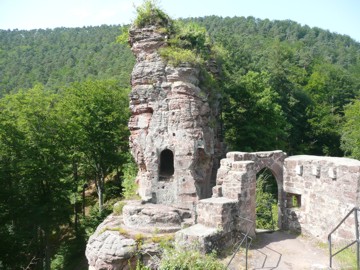
Site and Overall Layout
The castle occupies an
isolated, narrow sandstone spur oriented north–south, roughly 125 m long
and 8–15 m wide, rising 20–40 m above the surrounding terrain at ~370 m
altitude. A large artificial ditch (fossé) to the east separates the
spur from the main mountain massif, while the western and northern sides
drop steeply, providing natural defense. A geological fault splits the
spur into two autonomous rocky masses:
Northern rock (longer and
higher) — the “big castle” (grand rocher), containing the primary
defensive core, keep area, lower courtyard, and most troglodytic spaces.
Southern rock (smaller) — the “small castle” (petit rocher), almost
entirely occupied by a residential tower.
A modern footbridge
links the two at mid-height. The lower western courtyard on the northern
rock once held wooden dependencies (stables, etc.), while the ditch was
later enlarged to accommodate them. Access originally focused on the
northwest corner, with evidence of a drawbridge. Multiple rock-cut
staircases (north, south, and interior zigzag flights) and a hoist
system (monte-charge with a wheel against the rock wall) facilitated
vertical movement of people, supplies, and materials up the precipitous
site.
Materials and Construction Techniques
Builders used the
local reddish-pink Vosges sandstone almost exclusively: the rock itself
was quarried and carved in situ for lower levels, foundations, cisterns,
wells, stairs, and corridors, creating a seamless integration of natural
and built fabric. Upper stories combined ashlar stone masonry (lower
courses) with half-timbered (colombage or pans de bois) framing for
lightness on the narrow, elevated platform. Wooden beams were anchored
into rock sockets (visible traces remain). Defensive overhangs (hourd or
wooden galleries) and internal wooden floors are attested by notches and
corbels. Water management was critical: rock-cut cisterns (one square
near the footbridge, another conduit-shaped within a multi-story
building), a filtration cistern (later disused, with a well sunk into
its base), and protected springs. A 13th-century lordly lodging cellar
was fully carved from the rock. Later 15th–16th-century work added
artillery adaptations (embrasures for firearms) and engravings
(Fleckenstein coat of arms in a corridor; a dragon in the kitchen facing
the hearth, early 16th century).
Defensive Architecture
The
design prioritized inaccessibility and vertical defense:
Topography
and ditch — natural cliffs plus the eastern fosse created a strong
perimeter.
Pentagonal keep (donjon) — at the vulnerable northern tip,
facing the main approach; it served as the ultimate refuge. Dismantled
in the late 15th/early 16th century, its rock base was converted into an
open artillery terrace with wide embrasures for cannon/firearms.
Entrances and barriers — drawbridge evidence above a northern base door;
rock-cut corridors with floor notches for overhanging wooden sections;
protected water sources (well and cisterns shielded by narrow accesses).
Internal circulation — zigzag rock staircases, multiple levels of
troglodytic rooms, and a hoist system allowed defenders to move quickly
while exposing attackers to enfilade or vertical fire.
Lower
courtyard — west side of the northern rock, with traces of stables and
service buildings set into the enlarged ditch.
The castle evolved
from a pure rock stronghold in the 13th century to a more comfortable
seigneurial residence with artillery updates in the 15th century.
Key Architectural Elements by Section
Northern Rock (Big Castle)
Base (NW side): low rock-cut room joined by a narrow bay to a tiny
cylindrical chamber (likely the upper part of an old well-cistern).
Western projection: access door, winding rock staircase, traces of
stables, corner well, and additional rock stair vestiges.
Middle
level (east side): two rock-cut rooms; upper part of the old
well-cistern.
Upper terrace: remnants of keep and southward-facing
living quarters (largely inaccessible today).
Multi-story building
traces: at least three levels (stone lower, timber upper) containing a
conduit-shaped cistern-reservoir and zigzag rock staircase leading to
the inter-rock fault.
Kitchen: dragon engraving oriented toward the
former hearth.
Lordly cellar: 13th-century rock-carved space.
Fleckenstein arms engraved on a corridor wall.
Southern Rock
(Small Castle)
Entirely occupied by the residential (dwelling) tower,
built or heavily restored by the Fleckenstein lords. The standout
feature is the well-preserved Gothic ogival (pointed) arched doorway,
dated 1481 (variants in sources: 1484 or 1485). Associated rock-cut
elements include stairs to the fault and a small chamber accessed via a
probable cistern platform (perhaps with unfinished wooden
superstructure).
Historical Phases Shaping the Architecture
13th century — Original construction by the Froensbourg family (likely a
branch of the Fleckensteins), focused on rock-carved core and pentagonal
keep.
Mid-14th century — Divided among multiple lords; used as a
robber-knight base; besieged and largely destroyed in 1348–1349 by the
Landfriedensbund (Public Peace Alliance).
Late 14th–15th century —
Restorations (post-1358/1389); major Fleckenstein works in 1481–1485
added the south residential tower, timber upper stories, and later
artillery terrace after dismantling the old keep.
16th–17th centuries
— Abandoned; finally dismantled in 1677 by French royal troops under
Louis XIV to neutralize potential strongholds after Alsace’s annexation.
Current State and Visitor Experience
Only evocative ruins
survive: impressive rock-cut features (rooms, stairs, cisterns,
engravings), the Gothic doorway, wall fragments, and the layered
sandstone stratigraphy revealing construction history. The site is
freely described in guides but has been closed at times for safety
(degraded access staircase). It offers one of the finest surviving
examples of Alsatian rock-castle architecture, blending extreme
defensiveness with seigneurial comfort in a spectacular natural setting.
Detailed scholarly works, especially André Lerch’s studies on Vosges
rock castles, provide plans, reconstructions, and technical analyses of
its unique features.
This hybrid troglodyte–masonry design, adapted
over 400 years of conflict and ownership changes, makes Frœnsbourg a
quintessential specimen of medieval engineering in the contested
Rhineland borderlands.