Location: Scherwiller, Bas Rhin department Map
Constructed: 13th century
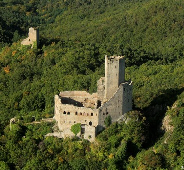
Château de L'Ortenbourg (or Ortenberg) is, with
the Ramstein, one of the two castles which dominate the town of
Scherwiller, located 7 km from Sélestat, in the Bas-Rhin department.
The ruins of the castle rise on a rocky peak, 437 m above sea level.
All of the two castles have been classified as historical monuments
since July 1924.
This castle takes its name from the
Ortenberg family, present in Scherwiller since the tenth century.
The chateaux is located on
the same ridge as the Ramstein chateau; at an altitude of 437m, it
overlooks the town of Scherwiller.
It can also be found (as
the crow flies) at:
6.25 km from Haut-Kœnigsbourg
7 km from
Sélestat
The current remains
The Château de l'Ortenbourg,
built in smooth and white granite in the 13th century, is a fine
example of military architecture from medieval Alsace. It still has
a 32m pentagonal keep, a 17m rampart with three rows of arches and a
stately home with Gothic windows. A large ditch separates it from
the rest of the mountain.
Origins (c. 1000 – mid-13th century)
The site’s history begins
around the year 1000, when Count Werner (Wernher) d’Ortenberg —
founder of the nearby Honcourt Abbey — built the first castle. The
Ortenberg family had been established in Scherwiller since the 10th
century. A diploma from Emperor Otto III confirms their presence.
The direct male line died out in the early 12th century (c.
1120–1162) with the death of the last heirs (Adélaïde and her
childless marriage to Count Lutold d’Achalm). The property then
passed to the powerful Counts of Hohenberg
(Zollern-Hohenberg-Haigerloch branch).
The Habsburg
Reconstruction (1258–1265)
The pivotal transformation occurred
when Rudolf (Rodolphe) I of Habsburg, Landgrave of Upper Alsace and
future King of the Romans (1273) and Holy Roman Emperor (1273–1291),
received the lordship as a dowry through marriage alliances with the
Hohenberg family. In 1258 Rudolf decided to rebuild the castle
entirely to make Alsace a strategic military stronghold for his
expansionist plans. Work began immediately on widening the rocky
platform and raising the ground level.
Construction faced early
setbacks: in 1261, during the war between Bishop Walter de
Geroldseck of Strasbourg and the city, the building site was
ravaged. The bishop was defeated and paid 700 marks in compensation,
allowing completion around 1265. The result was hailed as “the most
beautiful castle in Alsace” and one of the most advanced
13th-century fortifications in the region.
Key architectural
features (largely dating from this phase, with 1300 enhancements):
Pentagonal donjon (keep), 32 m high, built of white granite.
Surrounding chemise (enclosing wall) raised to 17 m, with five
defensive levels: high archers’ loopholes on the lower three, a
wooden hoard (brattice) gallery on the fourth, and crenellations on
the fifth.
Seigneurial logis (residential building) with elegant
Gothic windows.
Large defensive ditch separating the main castle
from the ridge.
Impressive entrance gate topped by an arrow slit.
The design allowed a tiny garrison (as few as 10–12
well-supplied men with artillery) to hold off much larger forces.
Early Sieges and Habsburg Struggles (1265–1314)
The castle
saw conflict almost immediately. In 1265, while possibly still
finishing, it endured a siege by episcopal troops. After Rudolf’s
death in 1291, his son Albert I clashed with Adolf of Nassau for the
imperial throne. In 1293 the Alsatian landvogt Otto IV of
Ochsenstein (supporting Nassau) besieged Ortenbourg, which was
defended by a strong episcopal garrison loyal to the Habsburgs. To
break the stalemate, Otto built the nearby Ramstein as a siege
castle and base. After three weeks of heavy losses for the
attackers, the defenders capitulated. Following negotiations and
Adolf’s death in 1298 (Albert becoming emperor), the castle returned
to Habsburg control.
Around 1300 the Habsburgs carried out
further upgrades: the enclosure wall was doubled in height, wooden
staircases to the residence were replaced by stone ones with a tower
landing, and additional arrow slits were added — confirming its
reputation as the most sophisticated fortification of its era in
Alsace.
In 1314, financially strained after wars against the
Swiss, the Habsburgs sold the castle and village of Scherwiller to
Henri de Müllenheim (a Strasbourg knight) for 3,000 marks.
Müllenheim Ownership, Brigandage, and Burgundian Interlude
(1314–late 15th century)
The Müllenheim family held it for
roughly two centuries, appointing a sworn guardian (Burguot)
responsible for defense. In 1374 troops of John I, Duke of Lorraine,
damaged the castle.
By around 1440, mounting maintenance costs
led to a “ganerbinat” — a form of co-ownership shared among up to 40
impoverished knights and minor lords. Many turned to brigandage,
ransoming travelers on the roads below the ridge.
In 1470 Pierre
de Hagenbach, bailiff for Duke Charles the Bold of Burgundy, seized
the castle to end the lawlessness. The small garrison (two nobles,
five hired soldiers, and six to eight laborers) surrendered without
resistance. A 1471 Burgundian report praised its defensibility: with
food and artillery, 10–12 men could hold the upper castle and keep
even if the lower court fell. Provisions recorded included a freshly
slaughtered cow, two salted pigs, herring, flour, and wine. The site
was briefly modernized with crossbows, culverins (one
Strasbourg-made fragment was later found), and powder. In 1471, with
help from Strasbourg troops and the bishop, Philippe de Müllenheim
recovered the rights.
16th–17th Centuries: Further Turmoil
and Destruction
In 1525, during the German Peasants’ War (“War of
the Rustauds”), peasant rebels were massacred at the foot of the
castle. In 1551 ownership passed to Nicolas de Bollwiller.
The
fatal blow came during the Thirty Years’ War. In 1632 Swedish troops
captured the castle without difficulty, pillaged it, and burned it.
Local peasants loyal to the imperial side launched a surprise attack
but were repelled; by 1633 the Swedes had largely dismantled the
structure, leaving the romantic ruins visible today.
Later
Owners and Romantic Restoration (17th–19th centuries)
The ruins
passed through several hands: briefly to the Fuggers of Augsburg,
then the Zurlauben nobles (1681, under Louis XIV), the
Choiseul-Meuse family (from 1710 until the French Revolution), and
finally, in 1806, to Baron Philippe-Gaétan Mathieu de Faviers, who
carried out major restoration and consolidation works. It later
transferred to the commune of Scherwiller.
Modern
Preservation (20th–21st centuries)
Classified as a Monument
Historique on 1 July 1923 (ruins protected 1924). In 1966 the
commune leased the site for 30 years to “Opération Taupe,” whose
goal was to restore it as the finest feudal monument in the Vosges.
Major consolidation works occurred in 2003. Since 2016 the local
association Les Sentinelles de l’Ortenbourg has managed ongoing
preservation, scientific restoration, public access, and cultural
animation.
Today the ruins are freely accessible via marked
hiking trails (e.g., from the Huhnelmühle parking area following red
GR5 rectangles, or from the Taennelkreuz chapel with blue crosses).
They offer sweeping panoramic views over the Alsace plain and remain
a powerful witness to medieval military engineering, dynastic
struggles, and the turbulent history of the Holy Roman Empire’s
western frontier.
Materials and Construction Context
The castle is built almost
entirely of smooth, white local granite, quarried from the site itself
or nearby outcrops. This gives the walls a clean, monolithic appearance
even in ruin, with precisely fitted ashlar masonry typical of
13th-century Alsatian high-quality fortification work. Sandstone was
used sparingly for decorative or functional details such as window
frames, gutters (chéneaux), and certain thresholds. Construction
occurred primarily between 1260 and 1265 under Rudolf (Rodolphe) of
Habsburg, who acquired the seigneurie through marriage and undertook a
near-total rebuild on the site of an earlier (possibly 10th–12th
century) fortification. The rocky platform was widened and leveled, and
the ground raised, creating a highly engineered defensive position
adapted to the steep terrain. Work was briefly interrupted by regional
conflicts (e.g., with the Bishop of Strasbourg), but the core structure
was completed rapidly.
Overall Layout and Design Principles
The castle follows a compact, linear plan optimized for a narrow
ridge-top site: it is essentially defensible from only one main approach
(the gentler ridge side), while the other flanks drop steeply or are
protected by natural rock. It divides into:
Basse-cour
(lower/outer courtyard): An enclosed service area with ancillary
buildings (stables, livery, possibly chapel or small rooms).
Haut
château (upper/inner castle): The residential and military core,
dominated by the keep and seigneurial logis (palace/residence).
A
large rock-cut fossé (moat/ditch), excavated directly into the granite
bedrock, isolating the main structures from the rest of the ridge and
preventing direct undermining or easy approach.
Access is via a
ramp (originally with a 15th-century drawbridge) interrupted by a haha
(sunken barrier for visibility and animal control) and protected by a
tour palière (stair or flanking tower). A postern (secondary gate) and
main gate (vast entrance topped by a vertical arrow slit) control entry.
The entire design emphasizes passive defense through elevation, natural
rock barriers, and minimal garrison requirements—contemporary accounts
note that 10–12 well-provisioned men could hold the upper sections
indefinitely, even if the basse-cour fell.
A preserved legend/plan
labels key elements: pentagonal keep, high chemise (enclosing wall),
lower courtyard, main gate, access ramp, postern, palace (logis),
stable-livery, small room, chapel, cistern, bridge, high gate, and
kitchen/guard room. A large central cistern collected rainwater via high
sandstone gutters from the roofs.
The Pentagonal Keep (Donjon)
The architectural centerpiece is the pentagonal keep, approximately
32–35 m tall with five (or up to six) levels of firing positions. The
unusual pentagonal form—rare but highly effective in 13th-century
mountain castles—provided optimal fields of fire and better deflection
of projectiles compared to square or round towers. It stands slightly
forward and is closely protected by a high chemise (outer enclosing
wall, also called rampart or mur-bouclier/shield wall) about 17 m high
and polygonal in plan.
Defensive layering on the keep/chemise:
Lower three levels: High, narrow archères (arrow slits/loopholes), often
niched for better coverage.
Fourth level: Gallery for wooden hourds
(projecting hoardings or fighting platforms, supported on corbels/beam
holes or consoles), allowing vertical defense (dropping stones, boiling
liquids, etc.) and additional loopholes.
Top: Crenellated chemin de
ronde (wall-walk/battlements) for archers or early artillery.
Total:
Up to six firing levels when including the chemise parapet and keep
summit.
Access to the keep was via a door roughly one-third up
its height (on the palace side), reached from the chemise via a former
balcony or bridge (beam holes visible). The keep’s interior is largely
ruined but originally contained multiple floors for storage, garrison
quarters, and command.
Residential Logis (Seigneurial Palace) and
Domestic Features
Adjacent to the keep is the seigneurial logis, a
substantial residential block that blends military austerity with Gothic
comfort. Its most distinctive feature is the series of large Gothic
windows—tall, pointed arches, often geminated (paired/twin openings)
with sandstone framing—on the first floor and upper levels. These
provided light and views while the ground floor remained more defensive
(smaller openings or none on attack sides). Inside the logis: a large
fireplace and sink (indicating a kitchen/guard room), and evidence of a
refectory or hall separated by a high wall. The attack-facing side has
no windows, serving as a solid shield wall. High sandstone gutters
drained water to the central cistern.
Defensive Systems and
Unique Military Features
Multi-layered defense: Natural rock + deep
fossé + chemise + mur-bouclier + keep created successive barriers.
Archery and vertical fire: Three rows of archères on the chemise; hourds
and crenellations for enfilade and plunging fire.
15th-century
upgrades: Artillery modernization (couleuvrines/cannons, powder stores)
and a drawbridge, reflecting late medieval adaptations.
Passive
strength: Massive granite walls absorbed siege impacts; the pentagonal
geometry and ridge position made it nearly impregnable to heavy engines
from most angles.
Small garrison efficiency: Designed for a handful
of nobles, soldiers, and servants, with self-sufficiency (cistern,
provisions storage).
The castle exemplifies the transition in
Alsatian fortifications: early reliance on natural topography and
high-quality masonry, with emerging Gothic residential elements in the
lord’s quarters.
Current State as Ruins
Today, the castle
stands as impressive ruins: the keep survives to near-full height
(though roofless and crenellations partially lost), large sections of
the chemise and logis walls remain with visible Gothic windows, beam
holes, and archères. The rock-cut moat is still evident, and the overall
layout is easily readable on site. Vegetation has reclaimed parts, but
the granite’s durability preserves the smooth, monumental quality. No
major post-13th-century structural additions survive except minor
15th-century repairs; it was burned by Swedish troops in 1632–1633
during the Thirty Years’ War and never fully rebuilt.