Location: 46 Rue du Ramstein, Baerenthal, Moselle department, Lorraine Map
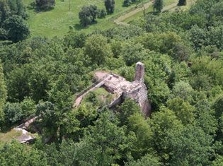
Château du Ramstein (also known as Ramstein Castle) in Baerenthal, Moselle department, northeastern France, is a ruined medieval rock castle (château-rocher) perched dramatically on a sandstone outcrop called Schlossberg at about 292 meters elevation. It overlooks the village of Baerenthal and the Zinselbach (Zinsel du Nord) valley in the Northern Vosges, a region rich in such fortifications. The ruins stretch approximately 265–270 meters along a narrow rocky crest (averaging 6 meters wide), making it one of the longest castles in the Vosges mountains. Today, only fragmented walls, rock-cut chambers, stairs, galleries, and the base of what was likely the palas (lordly residence) remain—no trace of a traditional donjon (keep) exists. The site offers sweeping panoramic views and is accessible via hiking trails from Baerenthal, with safety improvements completed around 2009–2010.
Origins and Construction (Mid-13th Century)
The
castle's history begins in the mid-13th century, with documentary
attestations as early as 1254 and clearer mentions by 1269. It was
built by a branch of the lords of Windstein (Winstein), specifically
the Ziedeler family, who served as ministeriales (hereditary
imperial officials or knights) and avoués (advocates/bailiffs) under
the Hohenstaufen emperors. This branch adopted the name "Ramstein"
(from the local Germanic "Rammestein," meaning "raven/crow rock" or
"crow stone," referring to the rocky site and possibly ravens in the
area).
Contrary to older sources that sometimes attributed it to
the lords of Falkenstein (a common mix-up with the separate Château
de Ramstein near Ortenbourg in Bas-Rhin), modern
scholarship—particularly the detailed 2026 study by
historian-archaeologist Jean-Michel Rudrauf in Châteaux forts
d’Alsace—confirms the Windstein connection through archival and
on-site analysis (including stone markings, notches, and landscape
context). The fortress was constructed on instructions tied to the
Bishopric of Strasbourg (to which it was dependent), to control the
strategic Zinselbach valley and the important route linking
Pirmasens (in the Palatinate) to Bouxwiller (in Alsace). It also
marked a border zone between the episcopal principalities of Metz
and Strasbourg.
The site exploited the natural sandstone geology
for defense: the vertical rocky platform itself formed the main
bulwark, with buildings adapted to the irregular crest. Construction
likely focused on the lordly residence, defensive walls, and
rock-hewn elements (two troglodyte rooms are still visible). Some
inventories, like Base Mérimée, date the main campaign to the 4th
quarter of the 13th century, though earlier documents suggest
initial fortification or planning in the 1250s–1260s.
Early
Ownership and Operations (Late 13th–Early 14th Century)
The
Ramstein family held primary control. Henri (Heinrich) de Ramstein
appears in records from around 1291–1294. Other mentions include
Heinrich von Uchterer (1306) and spellings like "Ramenstein" or
"Ramestein" (1318). Ownership was shared at times: in 1319 with the
lords of Fleckenstein, and by 1326 with the Dorschweiller (or
Dorschweiler) family of Torcheville.
The lords participated in
regional feudal networks—one notable episode involved Henri de
Ramstein and allies (including Walter de Mietesheim, Frédéric de
Wasigenstein, and Walter de Falkenstein) acting as guarantors for
the release of Henri de Windstein, imprisoned in Bitche Castle by
the Duke of Lorraine. The castle served its intended purpose as a
watchtower and control point but remained relatively modest compared
to larger neighboring strongholds.
The Brigand Period and
Destruction (14th Century)
By the early 14th century, the lords
of Ramstein had devolved into "pillaging knights" or robber barons,
using the isolated castle as a base for brigandage—raiding travelers
and locals along the valley route. They were summoned before the
powerful Lord of Lichtenberg to answer for their crimes but ignored
the call, relying on the slowness of feudal justice and the site's
defensibility.
In response, a punitive expedition in 1335 (not
1355, as some older English sources erroneously state) was launched
by troops of the Bishop of Strasbourg, allied with forces from Bern
(Switzerland). The castle was attacked, pillaged, and systematically
destroyed. It was never rebuilt, marking the end of its brief active
life (roughly 80–100 years). This event fits a pattern in the
Northern Vosges, where several small castles were razed due to
lawlessness during the fragmented Holy Roman Empire era.
Later History of the Ruins (15th–19th Centuries)
After
destruction, the site fragmented. In the 15th century, half the
ruins belonged to Count Louis V of Lichtenberg; the other half to
the lords of Bootzheim (Bootsheim), an illustrious family whose
notable member Johann von Bootsheim was a friend of Erasmus. Michel
de Bootzheim later sold his share to Philippe de Ramstein, a master
(high official) of the city of Strasbourg. Upon Philippe's death in
1569, the entire property reverted to the Count of
Hanau-Lichtenberg.
The ruins passed into the Hanau forest domain
and eventually became state property in modern times. They saw no
significant military reuse until the 20th century.
20th–21st
Centuries: Protection, WWII Connections, and Modern Access
The
ruins have been protected since at least the 1930s–1940s (listed or
inventoried around 1924/1938 per various sources; official Base
Mérimée reference IA00037761). Two underground passages/tunnels were
excavated below the castle in 1936 by French military engineers as
part of the Maginot Line fortifications (for supply storage or
shelters). These were used by locals during the harsh winter battles
of 1944–1945 but are now gated to protect bat colonies and closed to
the public.
In March 2008, the commune of Baerenthal signed an
18-year emphyteutic lease (long-term lease) with the state for the
site. Safety and accessibility works in 2009–2010 stabilized the
ruins, added railings, and improved paths. Today, it is a popular
hiking destination within the Northern Vosges Regional Nature Park
(Parc naturel régional des Vosges du Nord), with an orientation
table at the top describing the landscape. Recent archaeological and
historical research, especially Rudrauf's 2026 monograph (based on
extensive fieldwork since ~2007–2010, including precise site plans
and comparisons), has corrected longstanding errors about builders
and ownership, highlighting how the castle was long underestimated.
The ruins remain a poignant example of a short-lived medieval border
fortress—strategic yet vulnerable to internal feudal disorder. Its
pinkish-red sandstone remnants blend dramatically with the forested
Vosges slopes, evoking the turbulent history of Alsace-Lorraine.
For visitors, the site is best reached by foot from Baerenthal
(moderate hike, part of local "Sentiers d'excellence" trails). It
offers a quiet, atmospheric contrast to better-known castles like
nearby Grand-Arnsberg or the Ortenbourg group. Sources for this
history include French Wikipedia, Base Mérimée, the commune of
Baerenthal's site, Châteaux forts d’Alsace, and regional studies by
authors like Émile Mandel and André Lerch.
Site Integration and Overall Layout
The castle sits
atop the Schlossberg, a natural rocky outcrop of pinkish-red grès
bigarré (Buntsandstein or variegated sandstone) at approximately 292 m
elevation. This platform forms the entire foundation and primary
defensive system. It measures 265–270 m long (recent precise surveys by
Jean-Michel Rudrauf give 265 m; older sources cite ~270 m) by an average
width of only 6 m. The crest is irregular but remarkably straight and
narrow—like a natural stone spine rising steeply above the Zinselbach
(Zinsel du Nord) valley and the village of Baerenthal.
Because the
sides drop away in near-vertical cliffs (often 10–20+ m high), the
builders needed almost no artificial curtain walls along most of the
length. The rock itself served as impregnable “curtains.” The result is
a purely linear fortress stretched end-to-end along the ridge, with
functional zones (residential, service, observation) arranged
sequentially rather than in concentric baileys or courtyards. No central
donjon (keep) ever existed; the highest point of the crest provided
natural watch positions. A possible small moat or ditch (fossé) is noted
in inventories but remains unstudied and was probably minimal or relied
on natural gullies.
The layout is best understood as a single
defended “street” or platform walkway, with buildings and rock-cut
features fitted tightly to the available width. Access to different
sections relied on stairs and galleries carved directly into the
bedrock.
Defensive Architecture
Defense was almost entirely
passive and geological:
Sheer sandstone cliffs on both flanks made
direct assault extremely difficult.
Panoramic visibility over the
valley routes (Pirmasens–Bouxwiller) allowed early warning of any
approach.
The narrow crest prevented large siege engines from being
brought up easily.
Entrances were likely at the gentler ends or via
controlled rock-cut stairways, funneled into choke points.
No
trace remains of advanced defensive features such as machicolations,
arrow loops in built walls, or a gatehouse with towers. The natural
topography rendered them largely unnecessary.
Built Structures
and Masonry
The main surviving built element is the logis seigneurial
(lordly residence or palas). Its base and tall vertical fragments of
pink sandstone walling (up to 5–10 m high in places) are the most
prominent ruins visible from the valley. These walls use local rubble
and coursed sandstone masonry, bonded directly to the bedrock where
possible. Stone sizes and jointing vary according to function, as
meticulously documented by Rudrauf.
Other wall fragments (partition
or low curtain sections) divide the long platform into zones. All
masonry is modest in scale, reflecting the site’s constraints and the
castle’s short lifespan (built ~1250s–1290s, destroyed 1335, never
rebuilt). Notably absent are pierres à bossage (bossed or rusticated
stones), consistent with regional styles after ~1292.
Rock-Cut
(Troglodytic) Architecture
A hallmark of Vosges rock castles,
Ramstein features extensive carving into the living sandstone:
Two
chambres troglodytes — small cave-like rooms hollowed out of the rock,
probably used for storage, guard posts, or emergency shelter.
Rock-cut stairs (escaliers) — still visible and usable today, allowing
movement up and down the crest and between levels.
Galleries and
passages — narrow rock-hewn corridors for circulation or defense.
Beam sockets, notches, and entailles — numerous holes and grooves in the
bedrock (studied in detail by Rudrauf) that once supported timber
floors, roofs, joists, door frames, or even temporary wooden
hoardings/breastworks.
These troglodytic elements effectively
extended the usable space without widening the narrow crest.
Rudrauf’s 2026 Architectural Study
The most authoritative modern
analysis comes from Jean-Michel Rudrauf’s 32-page monograph published in
Châteaux forts d’Alsace (early 2026). Based on more than ten full days
of fieldwork (2007–2010 and final observations in 2025), plus archival
work and computer reconstruction, it provides the first truly precise
plan of the site. Rudrauf measured every remaining stone, mapped every
rock notch and socket, and reconstructed the likely timber
superstructures and phased adaptations. His work corrects centuries of
misattribution and shows how the builders constantly adjusted to the
irregular geology—every wall footing, stair tread, and room follows the
natural contours of the rock.
Later and Modern Interventions
1936: Two artificial underground tunnels were excavated beneath the
ruins by French military engineers as part of the Maginot Line
(supply/storage shelters). These are not medieval but are now part of
the site; they are gated to protect bat colonies.
2009–2010: Major
safety and conservation campaign by the commune of Baerenthal (under its
18-year emphyteutic lease from the state). Unstable masonry was
stabilized, modern safety railings were installed along the exposed
platform edges, and access paths were improved. These works preserve the
authentic ruined state while making the site safely visitable.
Current Appearance and Visitor Experience
Today the ruins appear as a
dramatic, atmospheric line of fragmented pink sandstone walls and
exposed bedrock stretching along the forested ridge. From below, the
tall palas remnant stands out like a broken tooth against the sky. On
the crest itself, visitors walk the narrow platform (now with railings),
climb the original rock-cut stairs, peer into the troglodyte chambers,
and enjoy 360° views. A natural “mushroom-shaped” sandstone outcrop
stands near the ruins as an additional landmark.
In summary, the
architecture of Château du Ramstein is a masterclass in 13th-century
pragmatic military engineering: it uses the geology as 90 % of the
fortress, supplements it with minimal but precisely placed masonry and
rock carving, and creates an efficient, elongated border watch-post
perfectly suited to its narrow, elevated site. Its brevity of occupation
(less than a century) preserved it as an unusually “pure” example of
early Vosges rock-castle design—modest, functional, and breathtakingly
integrated with the landscape.
The Château du Ramstein has been a protected historic monument since 1938, under the auspices of the French Ministry of Culture. It was classified as a monument historique in that year, recognizing its cultural and historical significance. However, public access has been prohibited since 1999 to safeguard a resident colony of bats, which use the ruins and caves as a habitat. This closure emphasizes ongoing conservation efforts, balancing heritage preservation with ecological concerns. Despite the restrictions, the site remains visible from afar and is a popular feature in local hiking trails, such as the 3.4-mile (5.5 km) Hasenkopf loop, which offers moderately challenging paths through the surrounding forests and provides panoramic views of the ruins.
While no specific myths or legends are prominently associated with Château du Ramstein in available records, its history as a brigands' lair evokes tales of medieval lawlessness and feudal intrigue. The castle's dramatic destruction and remote location contribute to a romanticized image of a forgotten stronghold amidst the Vosges wilderness. In the context of Baerenthal's broader lore, the area is steeped in stories of ancient Celtic druids, invasions, and the interplay between legend and reality, though these are more tied to the village than the castle itself.
Although the ruins are off-limits for close inspection, visitors can appreciate them from designated viewpoints along hiking routes in the Northern Vosges Regional Nature Park. The site is about 15 km southeast of Bitche, near the border with Bas-Rhin, making it accessible for day trips from Strasbourg or nearby towns. For those interested in exploring, trails like the one to Ramstein Castle via Komoot or AllTrails provide safe, scenic alternatives without entering restricted areas. Always check local regulations, as the prohibition on entry is strictly enforced to protect both the structure and its wildlife.