Location: Scherwiller, Bas- Rhin Department Map
Constructed: 1293
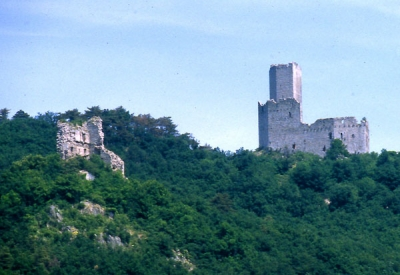
The Château de Ramstein, located in the Bas-Rhin department of France, is a medieval ruined castle perched on a rocky outcrop in the Vosges Mountains. It represents a classic example of Alsatian rock castle architecture, built primarily for defensive purposes during a period of intense feudal conflicts in the late 13th century. Unlike grander fortresses, Ramstein's design emphasizes functionality and adaptation to its rugged terrain, with a focus on a central residential tower and enclosing walls. Its history is intertwined with the neighboring Château de l'Ortenbourg, located just 200 meters northeast on the same ridge. The name "Ramstein" derives from Middle High German, combining "Ram" (meaning crow or raven) and "Stein" (stone), translating to "rock of the crow," likely referencing the site's avian inhabitants or ominous appearance. The castle's ruins today serve as a monument to medieval warfare, regional power struggles, and the enduring legacy of Alsace's Germanic influences under the Holy Roman Empire.
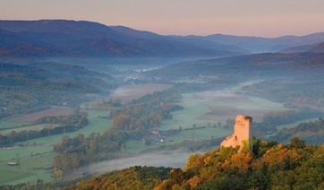
Ramstein is situated in the commune of Scherwiller, approximately 5 km northwest of Sélestat, in the Grand Est region. It occupies the southern end of the Rittersberg ridge at an elevation of about 390 meters, overlooking the surrounding valleys and forests of the Middle Vosges. The coordinates are 48°17′40″N 7°23′18″E. The site is naturally defended by steep slopes to the south and west, with access historically controlled via an L-shaped ditch that isolates it from the rest of the crest. This strategic position allowed oversight of key routes in the area, though it was overshadowed by the higher Ortenbourg Castle (at 437 meters). The surrounding landscape is densely forested, contributing to the ruins' picturesque yet overgrown state. Hiking trails, such as a 2.3-mile loop from Scherwiller with 728 feet of elevation gain, provide views of the site, often combined with visits to Ortenbourg.
Construction of Ramstein began at the end of the 13th century,
attributed to Otto IV d'Ochsenstein (also known as Otton von
Ochsenstein), the imperial landvogt (bailiff) of Alsace under Holy
Roman Emperor Adolf of Nassau. The earliest documented mention
appears in the Dominican Annals of Colmar from summer 1293, noting
that "the bailiff undertook the construction of the Ramstein
fortification near Sélestat against the will of many men." This was
amid a siege of the rebellious Château de l'Ortenbourg, held by the
Hohenstein family. Traditional historiography viewed Ramstein as a
dedicated siege castle, positioned a "crossbow shot" away to house
artillery for bombarding Ortenbourg. However, modern research
(post-2000s) challenges this, suggesting it may not have been
optimally sited for siege warfare—lacking supply line interdiction
and with better alternatives nearby. Instead, it might have started
as a wooden fortification, evolving into a permanent stone structure
post-siege.
By 1303, the castle came under Habsburg control
following their seizure of Ortenbourg in 1298. Otto renounced his
rights in 1307, and the Habsburgs transferred it to Volmar de
Reichenberg in exchange for his share in another castle. After
Volmar's death, his sons inherited it, with partial ownership
passing to Ulrich III de Wurtemberg in 1342. The Reichenberg line
extinguished in 1361, leaving the Wurtemberg family as primary
owners. Around 1388, Walther de Müllenheim held it as a fief, funded
for repairs by the Count of Wurtemberg. By 1420, Rudolf Zorn de
Bulach occupied it, leading to its sacking during the Guerre de
Dachstein (a conflict involving Strasbourg and Bishop Guillaume II
de Diest). Zorn recovered it post-war.
From at least 1437, the
Uttenheim family held the fief, adopting "zum Ramstein" in their
name. In 1470, during the Burgundian Wars, the Uttenheims allowed
Pierre de Hagenbach's forces passage, aiding the siege of Ortenbourg
and contributing to its surrender. The castle remained with the
Uttenheims until 1664. It was still habitable in the early 16th
century, as depicted in a 1514 drawing by artist Hans Baldung Grien.
However, it was burned by Swedish troops on April 1, 1633, during
the Thirty Years' War and never rebuilt. In 1810, Philippe-Gaétan
Mathieu de Faviers purchased the ruins, along with Ortenbourg; his
son consolidated them in 1864 with support from the Société pour la
conservation des Monuments historiques d’Alsace.
Ramstein exemplifies a medieval "tour-habitat" (residential tower)
fortress, adapted to its rocky site. The initial phase involved digging
an L-shaped ditch (about 10 meters wide) to isolate the outcrop,
providing granite moellons (rubble stones) for construction via on-site
quarrying. The core structure is a large, near-rectangular polygonal
tower (20 meters long by 15 meters wide), originally four levels high,
raised by two floors in the 14th century. Walls vary in thickness: north
at 1.4 meters (later plated to 2 meters), east at 2.3 meters. Materials
include local granite for the base and grès (sandstone) for upper
elements like window frames and chimneys, with original stucco coating
for weatherproofing.
The tower's levels include:
Lower level
(cellar): Three shooting slits (mostly infilled) for defense.
Second
level: Original ground floor with two north windows and one east (later
walled).
Third level (original habitation, 5 meters high): Four
cusped windows north, an eastern crossbow slit (possibly from the 1293
siege), supported by 14 beam consoles.
Fourth level (14th-century
addition): Habitation with cusped windows framing a chimney.
Fifth
level (attic): Small slits, low-pitched roof, and a rounded parapet path
with rainwater channels.
Below the tower to the west lies the
basse-cour (low courtyard), connected by a ramped wall. In the early
15th century, a fausse-braye (outer enclosing wall) was added for
additional defense, featuring thin walls with circular and
horseshoe-shaped towers: a U-flanking tower on the west, a smaller
southwest one, northeast and southeast circular towers, and a horseshoe
gate tower projecting 10 meters. Defenses focused on the northeast
terrace, with natural slopes protecting other sides. The ditch's western
arm directed runoff to a depression, possibly for watering livestock.
Access was via the eastern ditch end, crossing to the low courtyard
gate, then to the tower.
Ramstein suffered multiple assaults. It was sacked and pillaged by Strasbourg forces in the early 15th century during the Guerre de Dachstein due to Zorn de Bulach's alliances. Though recovered, it declined in strategic importance. The final blow came in 1633 when Swedish troops burned it during the Thirty Years' War, leaving it uninhabitable. Post-1664, it fell into gradual ruin until 19th-century acquisitions prevented further decay.
Today, the ruins consist primarily of the north wall and eastern half of the residential tower, along with partial basse-cour and fausse-braye elements, cleared through recent efforts. Classified as a monument historique in 1924 (reference PA00084970), it is owned by the commune of Scherwiller. Due to landslide and rockfall risks, the site has been officially closed to visitors since 1983, with entry prohibited. However, volunteer maintenance began in 2002, leading to the formation of the Les Veilleurs du Ramstein association in 2009. Restorations, including work on the tower, occurred as recently as 2020, revealing more of the enceinte and towers through archaeological digs. The site remains overgrown but stabilized, preserving its historical integrity.
Defensive Innovations: The fausse-braye with specialized towers
(e.g., U-flanking for enfilade fire) and ditch runoff system highlight
adaptive engineering.
Artistic Depiction: Hans Baldung Grien's 1514
drawing provides one of the earliest visual records, showing it intact.
Historiographic Debate: Once emblematic of siege castles, recent studies
(e.g., Wagener 2008, Bischoff/Rudrauf 2019) suggest it was more a
permanent fortification, possibly starting wooden.
Burgundian
Connection: The 1470 passage of Hagenbach's troops underscores its role
in broader European conflicts.
While direct access is forbidden for safety reasons, the ruins can be viewed from nearby hiking paths leading to Ortenbourg. Trails start from Scherwiller or Orschwiller, taking 1-2 hours round-trip. No entry fees apply, but respect closure signs. For virtual exploration, resources like the Alsace tourism site offer photos and histories. As of December 2025, no major changes to access have been reported, but check local updates via the commune or association websites.