Location: 2 Rue du Couvent, Dambach- la- ville
Bas-Rhin département Map
Constructed: 11-15th century
The Bernstein is a castle built on a granite ridge which dominates the town of Dambach-la-Ville, in the Bas-Rhin. It is located at an altitude of 562 m. It has been the subject of an inscription as a historical monument since December 12, 1932. It stands on a cliff at an altitude of 557 meters.
Legend tells us that the castle was built on the rock where a family of bears lived, hence its name. Indeed, Bernstein (or Bärenstein) literally means bear rock (from Bär, bear and Stein, rock).
The castle is one of the oldest fortresses in Alsace, if not the
oldest. It is mentioned for the first time around 1009. The present
ruins are much later and date from the end of the 12th or the
beginning of the 13th century.
The Bernstein originally
belonged to the Counts of Eguisheim-Dabo, Landgraves of Lower
Alsace. The first mention of the castle dates back to Hugues IV
d'Eguisheim when he supported the Emperor Henry II against the
Bishop of Metz. To better protect it, the count brought his wife,
Heilwige, mother of Pope Leo IX, there. The castle was alleu des
Eguisheim-Dabo from 1144 to 1225.
Count Albert II, allied
with Otto IV alongside his relative Conrad II of Hunebourg, bishop
of Strasbourg, in the conflict between him and Philippe of Swabia
for the election to the title of Germanic Roman Emperor. The
original building was probably destroyed at the end of the twelfth
century by Philippe, during a punitive expedition. The Counts of
Eguisheim subsequently reconstructed and reworked it in the volumes
that we know of today.
The two sons of Albert II de Dabo-Moha
died during a tournament organized by the Count of Flanders, Baudoin
IV. His daughter, Gertrude de Dabo, married to Thiébaud I of
Lorraine, therefore became the only heir. This is how Bernstein fell
into the possession of the Duke of Lorraine on the count's death in
1211.
When Gertrude de Dabo died in 1225, the fortress was
the object of heated disputes. Indeed, despite three marriages, she
did not give birth to any child. Supported by the bishop of
Strasbourg, Simon of Saarbrücken (Sigismond von Leinigen), count of
Linange, Gertrude's third husband, occupied the castle. But finally,
the bishop, revoking his protection, seized Bernstein after a
one-month siege in the year 1227. Bernstein was officially granted
to the bishopric by the Peace of 1236 with the consent of Emperor
Frederick II.
The castle came out ruined from this episode.
The bishop carefully restored it and made it the seat of a vast
episcopal bailiwick, the administration of which was entrusted to a
governor.
At the end of the 14th century, the building served
as a residence for bishops Jean de Lichtenberg from 1354 to 1365 and
Lambert de Burne in 1374.
In 1421, mercenaries from
Strasbourg invested it with the support of the bourgeoisie of
Dambach during the Dachstein war. In 1422, the Peace of Speyer
returned him to the bishopric. The Armagnacs ignored it in 1444.
During the Bundschuh revolts, it served as a refuge for peasant
insurgents.
At the end of the 16th century, the bishop bought
the city of Benfeld and transferred the seat of his bailiwick there
in 1580. The castle was deserted and remained abandoned. It was
looted and burnt down by the Swedes in 1632. During the
revolutionary period the castle served as an outlet for the
surrounding peasants and was sold as national property.
Architectural evolution
The first constructions on the Bernstein
site probably date from prehistoric times. The current northern
perimeter wall remains. It is a dry stone wall that scrupulously
follows the ridge border of the terrace.
Referring to the
uses of the time, the castle cited around 1009 was to be a
construction made mainly of wood.
The current remains of the
castle are very homogeneous, however it has been the subject of
additions and alterations over the centuries.
Most of the
fortress was built in several construction campaigns between the end
of the 12th century and the first third of the 13th century. The
oldest part is the high castle (keep, stately home and Roman tower).
Subsequently, the lower castle was built then the advanced
structures (front yard, drawbridge, garden and corner tower).
Much later, the house was transformed so as to create a ditch at
the foot of the keep, the Romanesque tower was raised and the
bastion built. The lack of excavations and the poor condition of the
remains make it impossible to date the work precisely. We can
nevertheless place them around the fourteenth century.
To
adapt to the progress of artillery, the Sainte-Marguerite tower was
built in the northwest corner of the lower castle towards the end of
the 15th century. At the same time, the ditch of the keep was
transformed into a cistern. The walls surrounding the upper
courtyard were also enhanced at this time.
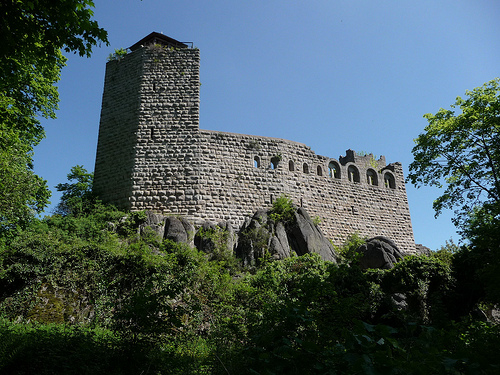
The fortress is entirely built in granite. The ruins that have come down to us are fairly well preserved6. The building sits on a granite ridge on two levels. This clearly delimits three distinct parts, namely the high castle located on the upper west ridge, the lower castle located on the lower east ridge, and finally the advanced structures resting on the south face of the rock.
The high castle is the oldest part of the
fortress, but also the best preserved. In fact, only a few rows of
stones are missing. From west to east, the high castle is divided
into several elements: the keep, the cistern, the stately home, the
Romanesque tower and the high barbican.
The pentagonal keep
faces Dachfirst Mountain and presents itself as a shield. Its
remains are approximately 18 meters high. In the nineteenth century
its battlements were still perfectly visible. The interior of the
dungeon is still accessible today, which shows the smallness of the
place. We deduce that the function of the keep was purely military.
At most, the lower level could serve as a dungeon. The keep has two
loopholes on its south face, a door facing east about 11 m above the
ground and latrines on the north face at the same level. Access to
the keep was via a sheltered and retractable footbridge from the
attic of the house.
The stately home or palas has two floors.
The first level was originally pierced with ten loopholes, four
facing south and the other six facing north. The loopholes in the
west of the house were condemned during the installation of the
cistern. The access portal is to the east. The second level housed
the ceremonial room and various living rooms. The south facade is
pierced with four twin windows to the east and five single windows
to the west. The windows are all semicircular. The east wall also
has a twin window vertically above the portal. The mullion featured
two carved bears. On the other hand, it is difficult to describe the
openings to the North except for a doorway on the side of the Roman
tower. Indeed, the northern wall of the second level has almost
entirely disappeared.
A tower, called the Romanesque tower,
stands in the northeast corner of the high castle. It stood on four
levels. The first of them is located slightly below the house. Its
ceiling is higher than that of the other rooms (about 5 meters). The
east wall is pierced with a loophole. The second level was to be a
more sumptuous room insofar as it had a ribbed vault and walls
pierced on all four sides by a twin window to the east, a single
window to the north and south and finally a door. semicircular to
the west. It is likely that the vault was destroyed during the later
elevation of the tower. The masonry of the third level is different
from that of the lower levels. Access to the three levels was from
the house. The remains of the fourth level show traces of
battlements. There is also an additional door, later, allowing
access to the attic of the house. Finally, the Romanesque tower
seems to have housed the castle chapel.
The east of the high
castle is occupied by the high barbican which occupies the space
between the two towers. It is currently encumbered by large
embankments. The access staircase between the lower and upper parts
of the castle crosses it from East to West. Two terraces of uneven
surfaces are located on either side of the staircase. In the
northeast corner, a staircase provided access to the
Sainte-Marguerite tower. The eastern retaining wall has a loophole
to watch over the lower castle. The north wall has obviously been
raised during subsequent improvements. The openings in the adjacent
wall of the Romanesque tower, the remains of a rectangular opening
to the north as well as the underlying corbels suggest the presence
of a floor extended by a small corbelled building on the enclosure.
The barbican could therefore have three levels.
A rainwater
recovery cistern has been fitted between the keep and the main
building.
The lower castle
The lower castle is currently
presented as a space of about 40 meters from west to east over 13
meters from north to south. Few vestiges remain from medieval times.
The northeast corner is currently occupied by the ruins of a 19th
century hunting lodge.
The northwest corner is occupied by the Sainte-Marguerite tower.
Judging by its location and structure, its function was essentially
defensive: it allowed the entrance gate to the lower castle to be
monitored. The tower, rectangular in shape, is pierced with
loopholes, suitable for firearms, staggered on the east and south
facades. Two accesses allowed access to the tower: one on the south
facade, located 6.50 meters from the ground and provided with a
drawbridge, formed the outlet of a staircase perpendicular to the
main staircase. The other, on the west facade, overlooked the high
barbican. To the right of the tower, a postern allowed passage to
the outside North. Some authors place the castle chapel in the tower
of the lower castle.
Other buildings forming the main
building existed in the courtyard, both on the north wall and the
south wall. In view of the remaining traces, they rose to two
floors. However, we note that their first level was blind on the
side of the surrounding wall. Some windows remain in the eastern
part of the courtyard: they are simple or twin, semicircular or
rectangular. On the other hand, the state of the ruin is not
sufficient to deduce the arrangement of the openings in the western
part.
Advanced works
The advanced works are located at the
foot of the high castle at the south-eastern corner of the rocky
outcrop. They include from East to West three main parts: the
bastion, the garden and the front yard.
The bastion has a
wall curving outwards from the castle. To the south-east stood a
corner tower. This was the only protection of access to the well
before the construction of the bastion in the 15th century.
The garden extends the bastion. Its southern wall rises on a rocky
base that can reach several meters. To the east, to the right of the
bastion, a passage provides access to the northern ditch. The
entrance to the passage to the underground well is located in the
southwest corner: a Romanesque portal gave access to the well via a
vaulted passage nine meters long.
The front yard is the best
preserved part of the advanced works. This courtyard is the only
access to the castle. In the eastern part, we can clearly see the
Romanesque portal. This had a drawbridge and a rectangular postern
to the south. North of the gate a wall separated the front yard from
the garden. It is pierced with a door and a loophole. The remains of
corbels and stone arches allow us to deduce the presence of a
walkway. Through a narrow corridor of about twenty meters by five,
the front courtyard leads to the portal of the lower castle.
The fortress also had a surrounding wall. The northern part is still
perfectly visible although very ruined. While walking along the
southern rampart walk, the visitor notices the presence of an
alignment of stones flush with the ground in the continuity of the
northern wall. One can thus imagine that the surrounding wall also
extended on the south face.
Military analysis
In its
design, the Bernstein castle presents a perfect defense. The natural
location is particularly favorable: the fortress is built on a rocky
outcrop which, combined with the surrounding terrain, offers a
significant drop in height over practically its entire periphery.
The military architecture is, for its part, particularly ingenious:
a thick pentagonal shield, pointed in the direction of the attack,
hides and protects all the outbuildings built in a row.
Put
in situation, the building has important weak points. The rocky
outcrop, and therefore the castle, points to a nearby hill - to the
east - but not to the attacking side. Indeed, the attackers found
more favorable terrain to the south-east. In addition, the water
supply comes from a well located outside the two main parts (upper
and lower castles). Preserving this access to water condemns any
idea of building a perimeter ditch at this location and makes
advanced structures all the more vulnerable.
These elements
undoubtedly explain the later adaptations of the castle, namely the
construction of the bastion and the installation of a cistern at the
foot of the keep. Developments in weaponry, and in particular the
appearance of cannons, ultimately made the castle obsolete. By the
end of the 16th century, the Bernstein had lost its strategic and
military importance and was therefore abandoned.
A few
kilometers to the south, stands another fortress, the Ortenberg
which has great similarities. Built between 1262 and 1269, it seems
to have been inspired by the architecture of Bernstein while drawing
on his experience.