Location: Rue de Schotten, Oberhaslach Map
Château du Grand Ringelstein, also known as Château Ringelsbourg, is a dramatic medieval ruined castle perched on a rugged sandstone outcrop in the commune of Oberhaslach, in the Bas-Rhin department of France's Grand Est region, within the heart of Alsace and the Vosges Mountains. Situated at coordinates 48°33′47″N 7°19′16″E and an elevation of 644 meters, it overlooks the lush Bruche Valley, dense forests, and distant glimpses of the Alsace plain, offering a commanding view that once served as a strategic vantage point for surveillance and defense. Constructed in the early 13th century (with masonry suggesting late 12th-century origins), the fortress was built around natural rock formations, embodying the era's innovative rock-integrated architecture. Classified as a monument historique since December 1898 and owned by the French state, it attracts around 20,000–30,000 visitors annually, drawn to its haunting ruins, hiking trails, and immersive connection to Alsace's feudal past. As of October 2025, the site remains free and open for self-guided exploration, with no major events or restorations reported, though minor trail maintenance by the Club Vosgien ensures safe access amid the site's natural isolation.
The castle's documented history begins in the mid-12th century, when
it first appears in records as a possession of the influential
Eguisheim family—counts of a prominent Alsatian lineage tied to the
Holy Roman Empire and even the election of Pope Leo IX (born Bruno
d'Eguisheim) in 1049. Following the extinction of the Eguisheim line
in the late 12th century, the estate passed to the Bishopric of
Strasbourg, reflecting the region's ecclesiastical control over
secular fortifications. By 1228, it was explicitly noted as an
episcopal holding, serving as an administrative center for domain
management in the 14th century. This period of stability was
short-lived; in 1366, during the sale of the Bruche Valley by the
bishop to the Count of Salm, the castle was notably excluded,
possibly due to its strategic or administrative value.
The 14th
century marked a turbulent shift. During the 1338 siege of the
nearby Château de Hohenstein by forces of the Bishop of Strasbourg,
Grand Ringelstein was hastily fortified as a forward base: its upper
enclosure was elevated rapidly, and a catapult projectile was later
discovered embedded in the walls, attesting to the conflict's
intensity. By the late Middle Ages, the castle had devolved into a
notorious lair for "robber knights" (chevaliers-brigands)—outlawed
nobles who preyed on trade routes through the Vosges
passes—exacerbating regional instability amid the Hundred Years' War
and feudal fragmentation. This lawlessness culminated in its
destruction in 1470, ordered by authorities to curb banditry; the
fortress was razed and never rebuilt, its stones quarried for local
use. Post-destruction, it faded into obscurity, preserved only by
its remote location. The 19th-century Romantic revival of interest
in medieval ruins led to its 1898 classification, with
archaeological surveys in the 1970s–1980s (e.g., by Charles-Laurent
Salch) uncovering its layered history. Today, it stands as a
testament to Alsace's borderland volatility, bridging imperial,
episcopal, and imperial influences under French sovereignty since
1648.
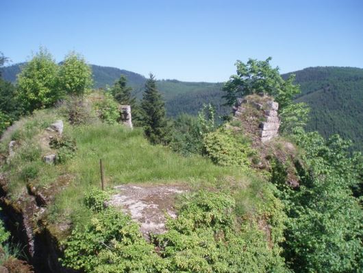
Grand Ringelstein exemplifies early 13th-century rock castle
(château-rocher) design, ingeniously integrated into multiple
sandstone spurs that form a natural defensive motte, spanning about
1–2 hectares. The core structure is a polygonal enclosure wall of
bossed (protruding) pinkish sandstone blocks—up to 2 meters thick in
places—hugging the irregular rock contours for maximal protection on
three sides, with only the northern approach vulnerable. This
enceinte, best preserved on the southwest facade, features small
arched openings likely for drainage or archery slits, and a dry moat
(fossé) that doubled as a quarry during construction around 1200. At
the site's northern summit, the most accessible point, stands the
remnant of a pentagonal keep (donjon), its five-sided form adapting
to the cliff's geometry; only the lower walls and foundations
survive, measuring roughly 10–12 meters across, with evidence of a
vaulted base.
Other scant remains include low buildings leaned
against the rocks for shelter, a rock-hewn cistern (citerne) carved
directly into a fissure for water storage—vital in sieges—and traces
of hasty 14th-century reinforcements like elevated ramparts. No
grand halls or chapels persist, emphasizing its austere military
purpose over residential comfort. The ruins' fragmented
state—ivy-clad arches, tumbled boulders, and exposed bedrock—evokes
a raw, untamed aesthetic, enhanced by the site's tri-spur layout
connected by narrow ledges.
The surrounding landscape amplifies
its isolation: nestled in the Ringelsberg massif of the Middle
Vosges, it rises amid thick beech, oak, and fir forests, wildflower
meadows, and sheer 50–100-meter drops into the Hasel and Bruche
gorges. Spring orchids and ferns carpet the slopes, while autumn
brings vibrant foliage; on clear days, vistas extend 20–30
kilometers to the Black Forest and Strasbourg's silhouette. Nearby
quarries supplied dressed stones for the castle and siblings like
Petit-Ringelstein (a primitive dry-stone ring 61m x 21m, possibly a
siege camp from 1338) and Hohenstein, forming a clustered "castle
group" in the massif.
Though not a designated reserve, the site's Vosges setting fosters rich biodiversity. Forests host native hardwoods (beech, oak) and conifers (silver fir), with understory ferns, mosses, and edible berries like bilberries drawing foragers. Meadows bloom with wild orchids, gentians, and alpine asters in summer, supporting pollinators. Fauna includes Vosges staples: red deer and roe deer roam the woods, foxes and badgers den in rocky crevices, while birds like peregrine falcons, buzzards, and woodpeckers nest on cliffs—ideal for spotting during dawn hikes. The cistern and moist rocks harbor amphibians like salamanders, and insect diversity peaks in warmer months. Conservation by the Club Vosgien maintains trails without disturbing habitats, preserving this as a quiet ecological haven amid Alsace's wine-focused lowlands.
Hiking is the premier activity, with the Club Vosgien's well-marked
paths offering immersive exploration. The main 3–4 km round-trip
trail ascends 300 meters from Oberhaslach's town center (starting at
the Hasel River bridge), taking 1–1.5 hours uphill through shaded
forests and boulder fields to the ruins—moderate difficulty with
some steep, rooty sections and chain-assisted scrambles near the
keep. At the summit, a 20–30-minute loop circles the spurs, crossing
precarious rock bridges for vertigo-tinged views and photo ops.
Extend to the 1 km side trail to Château de Hohenstein (another
13th-century ruin, 10–15 minutes away) or the primitive
Petit-Ringelstein (additional 1–2 km, via dry-stone enclosure),
creating a 5–7 km "castle circuit" with interpretive signs on
medieval sieges.
Birdwatching thrives year-round, especially
spring migrations, while families enjoy rock-scrambling and picnics
on the enclosure walls. In winter, snowshoes transform paths into
scenic treks (check conditions). No formal guided tours, but the
Saverne tourism office offers free audio guides via app for
historical narration. As of 2025, no dedicated events like
reenactments are scheduled—unlike busier sites like
Haut-Koenigsbourg—but the site ties into broader Vosges heritage
walks, including the GR5 long-distance trail nearby.
Minimal on-site: no facilities beyond basic signage and a summit bench for rests; pack water, snacks, and maps (downloadable from visitalsace.com). The ascent trailhead in Oberhaslach has free parking (20–30 spots) and connects to village amenities—a bakery, café (e.g., Café de la Paix for tarte flambée, €10–15), and restrooms. For overnights, Oberhaslach offers cozy gîtes and B&Bs like Hôtel du Barrage (€60–90/night, river views) or campsites 2 km away. Strasbourg, 40 km north, provides broader options via TER train (30 minutes, €5–10). Picnic areas abound in the forests below.
Free access year-round from dawn to dusk, weather permitting—no barriers or fees, but the terrain demands fitness: uneven rocks, steep inclines (20–30% gradients), and exposed edges make it unsuitable for wheelchairs, strollers, or those with vertigo/mobility issues. Sturdy hiking boots are essential; leashed dogs allowed but watch for wildlife. Rules follow French heritage norms: stay on paths to prevent erosion, no littering (pack out), drones prohibited without permit, and fires banned. Club Vosgien signage warns of rockfalls—avoid after rain. Check Météo France for fog/snow, which can obscure trails; in 2025, no closures from restorations, but seasonal overgrowth may narrow paths.
Drive D1420 from Strasbourg (45 minutes) or hike from the TER station in Oberhaslach for eco-friendly arrival. Start early (8–9am) to dodge midday heat or crowds (rare, but weekends busier); allocate 2–3 hours total, longer for the full circuit. Bring layers for variable altitudes (cool breezes at summit) and binoculars for views. Tripadvisor and Petit Futé reviews (4.5/5 average, 50+ in 2025) rave about the "magical, untouched ruins" and "epic panoramas," with hikers praising the "authentic scramble" but noting "slippery after rain." Families call it a "hidden gem for adventure," while history fans appreciate the "robber knight lore." Combine with nearby Nideck Waterfall (5 km) or wine tasting in Barr (15 km). As one 2025 reviewer quipped, "Like stepping into a forgotten fairy tale—raw, rewarding, and utterly Alsatian." For solitude-seekers, it's a quieter alternative to restored fortresses, embodying the wild spirit of the Vosges.