Location: 4 km (2.5 mi) West of Paiania
Tel. 210 664 2108
+30 10 664 2910
Open: 9am- 4:30pm daily
Entrance Fee: 2 Euro
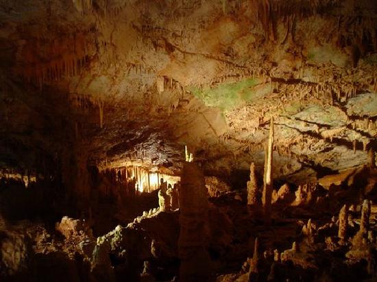
Koutouki Cave (Greek: Σπήλαιο Κουτουκιού), also known as Paiania Cave or Spilia Koutouki, is a remarkable limestone cave located on the eastern slopes of Mount Hymettus in Paiania (Peania), East Attica, Greece, approximately 25 kilometers southeast of Athens and near the Athens International Airport. Discovered in 1926, it is the largest and most accessible cave in the Attica region, spanning a total explored length of about 350 meters with a main chamber measuring 60 meters by 60 meters and a maximum depth of 38.5 meters. The cave is renowned for its rich and diverse speleothems (cave formations), including multicolored stalactites, stalagmites, columns, draperies, and flowstones, many tinged with rust-red hues from iron oxide deposits. As a protected natural monument, it maintains a constant temperature of around 17°C (63°F) and high humidity, creating an otherworldly subterranean environment. Managed by the Greek Ministry of Culture, it serves as a popular day-trip destination from Athens, attracting visitors for its geological beauty and guided tours featuring a light and sound show. In 2025, the cave continues to be a highlight for eco-tourism in Attica, emphasizing sustainable visitation.
By Car
From central Athens, head east on the Attiki Odos (A6)
highway toward Eleftherios Venizelos Airport.
Take exit 17 for
Markopoulo/Paiania.
Follow the signs toward Paiania, then continue
following signage for Koutouki Cave (Σπήλαιο Κουτουκιού).
The total
distance is about 35 km, and the drive typically takes 40-60 minutes
depending on traffic.
Parking is available near the cave entrance.
If coming from Athens International Airport, it's even closer (about 20
km): take Attiki Odos (A6) west toward Athens, then exit 17 for
Markopoulo/Paiania and follow the same signs.
By Public Transport
Public transport gets you to Paiania town, but the final 4-4.5 km to the
cave is uphill and often requires a taxi or walk, as no buses go
directly to the entrance. The cave is at an elevation of 510 meters, so
walking involves a steep climb.
From Central Athens (e.g.,
Syntagma Square):
Take Metro Line 3 (blue line, toward Airport) to
Nomismatokopio station (about 20-25 minutes from Syntagma).
From
Nomismatokopio, transfer to bus 308 toward Koropi Station.
Get off at
the 1st Agias Triadas stop (or 2nd Agias Triadas if coming from the
opposite direction; confirm with the driver).
From there, walk
approximately 4 km uphill (20-30 minutes) or hail a taxi for the last
leg (about 5-10 minutes, costing 5-10 euros).
Alternative Route:
From Nomismatokopio or Ethniki Amyna station (also on Metro Line 3),
take bus 125 toward Varkiza.
Get off at the 1st Koryfis stop in
Paiania.
Then, take a taxi or walk the remaining 4-4.5 km uphill to
the cave.
Other Buses: Lines 307 and 308 also serve areas near
Paiania and may stop closer depending on the exact route—check real-time
via Moovit for options from stations like Doukissis Plakentias or
Koropi.
Total time: 1-1.5 hours from central Athens, plus the final
walk/taxi. Buses run frequently (every 15-30 minutes during the day),
but service is reduced on weekends/holidays.
By Taxi or
Ride-Share
A taxi from central Athens to the cave costs around 30-40
euros and takes 40-60 minutes, depending on traffic.
From Athens
International Airport, it's shorter (about 20-30 minutes) and cheaper
(around 20-30 euros).
Use apps like Uber, Bolt, or local taxi
services for convenience. Many drivers know the location, but specify
"Σπήλαιο Κουτουκιού" in Greek.
Organized tours or private transfers
are also available, often combining the cave with other sites, starting
from 270 euros for a small group.
What to Expect Inside
Koutouki is a single large chamber (roughly
60x60m) divided into smaller sections by columns and walls of
formations. The tourist path is a well-maintained, easy 350m loop (about
30-minute guided tour) with stairs, railings, and paved
walkways—suitable for most visitors, including families with small
children, though those with mobility issues should note some steps.
Key highlights include:
Diverse speleothems (stalactites,
stalagmites, columns) in varied colors due to iron and other mineral
oxides—ranging from white/cream to reddish-brown.
Named formations
like the "Harmonium," "Red Waterfall," and "Olympic Torch."
Constant
17°C (about 63°F) temperature and high humidity year-round—cool and damp
regardless of outside weather.
Visiting Tips
Best time to
visit: Mornings or early afternoons. Tours run on a schedule (often
hourly), so arrive early to avoid waiting. Spring and autumn offer
pleasant outside weather; summer visits provide a refreshing cool
escape, but bring a light jacket/sweater. Winter can be chilly outside
but still comfortable inside.
Duration: 30–45 minutes for the tour +
time for views outside. Combine with a half-day trip from Athens.
Photography: Generally allowed, but avoid flash if restricted to protect
formations. Tripods may not be practical on the guided path.
What to
wear/bring:
Comfortable, non-slip closed-toe shoes (paths can be
slippery when wet).
Light jacket or layers for the constant cool
temperature.
Water bottle and perhaps a small backpack.
Cash for
tickets (cards may not always be accepted).
Accessibility &
rules: Guided tours only—no self-guided. No touching formations. Follow
guide instructions for safety and preservation. Children must stay with
adults.
Crowds: Not usually overwhelming, but weekends and holidays
can be busier. Tours may pause if guides need breaks (temperature
management).
Practical Info
Tickets: Historically €4–5 adults,
reduced for students/seniors/children (sometimes as low as €2 in
winter/off-season). Free or discounted for certain groups. Confirm
on-site.
Opening hours (when open): Typically daily
~8:30/9:00–15:00/15:50, last tour around 14:30. Varies seasonally—always
verify.
Location & views: Stunning panoramic views over the Mesogeia
plain and toward Athens from the parking/entrance area—great for photos,
especially at sunset.
How to get there:
By car (recommended):
~30–40 minutes from central Athens. Easy drive via highways; parking
available. Ideal for airport visitors (short taxi ride).
Public
transport: Metro to Nomismatokopeio station + Bus 308 (or 307/125). Get
off at Agias Triadas stop, then taxi or ~4km uphill walk (steep in
parts). Not the most convenient.
Taxi/Tour: From Athens or airport
~€30–50 one way. Private tours or airport transfers often include it.
Nearby: Pair with Paiania town, other Hymettus spots, or even a quick
airport layover visit (when open).
The cave's discovery in 1926 was accidental: a local shepherd noticed his goat had fallen through a small opening in the hillside, leading him to explore the fissure and uncover the vast underground chamber. Initial explorations revealed its impressive size and formations, prompting scientific interest. By the 1950s, the cave was developed for tourism under the auspices of the Greek Archaeological Service. An artificial entrance tunnel, 17 meters long and sloping downward, was constructed to provide safe access, replacing the original narrow vertical shaft. The site opened to the public in the 1960s, with pathways, stairs, and lighting installed to facilitate guided tours. Over the decades, it has undergone restorations to preserve its natural features, including measures to control humidity and prevent vandalism. Archaeological surveys have found limited evidence of ancient human use, such as Neolithic tools and pottery fragments, suggesting occasional shelter by prehistoric inhabitants, though no major settlements were established due to the cave's inaccessibility. In modern times, Koutouki has been featured in travel guides and documentaries, boosting its popularity. As of 2025, it remains under protection, with ongoing monitoring for seismic activity given Greece's earthquake-prone geology.
Geological Setting and Host Rock
The cave developed within the
Jurassic thick-bedded marbles (metamorphosed limestones) of the "Lower
Marble" unit, part of the Attica Geotectonic Unit. These marbles form
the core of Mount Hymettus, which is a north-south trending limestone
range along the eastern border of the Athens basin and belongs to the
broader Attic-Cycladic metamorphic belt. The protoliths (original
limestones) date to the Mesozoic (Triassic to Lower Jurassic), later
metamorphosed during the Alpine orogeny. The local structure is an
anticline with a NE-SW axis, dipping southeast toward the Messogia
region.
The host rock consists of massive, thick-bedded marbles with
prominent discontinuities: joints, faults, and bedding planes. These
tectonic features were critical in guiding cave development. Regional
karstification affects much of Hymettus, but caves here tend to be
vertical due to the steep topography and fracture-controlled hydrology.
Speleogenesis (Cave Formation Processes)
Koutouki Cave is a
classic karst cave, formed primarily through chemical dissolution of
calcium carbonate (CaCO₃) by meteoric (rain) water enriched with
dissolved carbon dioxide (CO₂), forming weak carbonic acid (H₂CO₃). This
process dissolves the marble along fractures and bedding planes,
enlarging voids over time. Over 95% of caves worldwide form this way,
and Koutouki is no exception.
Tectonic activity played a major
role:
Fractures and joint sets provided initial pathways for water
infiltration.
The cave's overall form and internal divisions align
with the main joint systems: primary E-W (090°–270°) and N-S
(010°–190°), with secondary NNE-SSW (025°–205°) and NE-SW (050°–230°).
Measurements of discontinuities (both surface outcrops and inside the
cave) confirm these orientations control corridor and speleothem
placement.
Speleogenesis began in the pre-Pliocene (likely
Miocene or earlier), with two distinct corridor types:
Narrow and
high corridors — formed by dissolution along steeply dipping joints,
faults, and bedding planes, often filled with secondary calcite.
Low
and wide corridors — resulting from subsurface erosion, roof/wall
collapse, and block fall along bedding planes parallel to the ceiling.
Development started in the western part (higher elevations) and
widened eastward. A tectonic crack in the bedrock roof later created the
natural vertical entrance shaft. The cave is part of the larger
underground karst system of Mount Hymettus. Some popular sources
approximate the process as taking ~2 million years, though precise
dating is tied to pre-Pliocene initiation with ongoing speleothem
growth.
Morphology and Structure
Koutouki is a vertical pit
cave that opens into a single, enormous chamber:
Natural entrance: A
38.5 m deep vertical shaft on the northwest side (originally the only
access; a goat famously fell through in 1926).
Main chamber: Roughly
60 m × 60 m horizontally.
Tourist route: ~350 m long circular path
(artificial 17 m tunnel entrance added later for visitors).
Vertical
relief: Floor elevations range from ~504 m (east, lowest) to ~525 m
(west, highest), with a mean of ~516 m. Maximum roof-to-floor distance
reaches ~18 m near the natural shaft.
Cavity volume: Approximately
6,800 m³ (open space), plus ~91 m³ of speleothems.
The chamber is
subdivided into smaller halls and corridors by massive stone curtains
(draperies/flowstones) and walls of joined speleothems that grew along
bedrock fissures and joints. This creates a labyrinthine feel despite
being one primary void. The cave widens westward, with greater vertical
differences there.
Speleothems and Decorations
Koutouki is
renowned for its rich, multicolored speleothems (secondary mineral
deposits), primarily calcite:
Stalactites, stalagmites, and columns —
Abundant; a 2020 high-resolution 3D laser-scanning study identified
exactly 55 columns. Average height ~2.5–3.9 m; tallest ~7.2–7.23 m (near
natural entrance). Widest and tallest columns cluster in the
west-central area, marking the likely origin of cave development.
Curtains, draperies, and flowstones — Prominent along fissures, dividing
the chamber.
Other forms — Named features include the “Red
Waterfall,” “Olympic Torch,” “Harmonium,” “Owl,” “Corals,” and “Armor.”
Colors — Striking reds, oranges, and earth tones from iron oxides (and
other minerals) carried by percolating water.
Speleothem growth
post-dates the main cavity formation (vadose zone deposition). Columns
often connect stalactites and stalagmites; growth rates and volumes are
higher in the western part (associated with higher, joint-controlled
corridors). A notable 7 m long marble block fell from the ceiling,
deflecting later speleothem growth and creating two generations of
formations.
Microclimate and Other Features
The cave maintains
a stable microclimate: temperature 14–17 °C year-round (often cited as
~17 °C) and relative humidity ~87–90 %. It once hosted bats and supports
troglobitic fauna, including endemic cave crickets (Dolichopoda
petrochilosi) and spiders.
Modern Scientific Insights
High-resolution 3D modelling (using handheld laser scanning, ~80 million
points) by Konsolaki et al. (2020) produced detailed digital surface
models (DSMs) of floor, roof, and speleothems. This allowed precise
quantification of volumes, column statistics, and correlation of
features to tectonic joint sets—confirming structural control on both
cave morphology and speleothem distribution. The methodology also
enables future monitoring of karst evolution. Earlier work (e.g.,
Dermitzakis & Lekkas, 1970s) highlighted the discontinuous tectonic
deformation influencing cave orientation.
While not as rich in fossils as some Greek caves, Koutouki has yielded paleontological finds, including bones of Ice Age animals like deer and small mammals embedded in the sediments, dating back tens of thousands of years. These remains provide insights into the region's prehistoric fauna and climate. Ecologically, the cave hosts a fragile ecosystem with troglobitic (cave-adapted) species, such as blind insects, spiders, and bats (including the lesser horseshoe bat). The high humidity supports fungal growth and microbial communities that contribute to the cave's ongoing formation processes. Human impact has been minimized through controlled access, but light pollution from tours can affect bat populations. No major archaeological sites exist, but scattered Neolithic artifacts suggest brief use by early humans for shelter or rituals. The cave is part of broader conservation efforts in Mount Hymettus, a protected area under Natura 2000 for its biodiversity, including endemic plants and birds above ground.