Location: Map
Philippi (Φίλιπποι), in northeastern Greece near the modern village
of Krinides (about 15 km northwest of Kavala), is one of the most
significant archaeological sites in the country and a UNESCO World
Heritage Site since 2016. The remains of this walled ancient city
lie at the foot of a fortified acropolis along the Via Egnatia—the
major Roman road linking Europe and Asia—preserving layered history
from the Hellenistic, Roman, and Early Christian periods spanning
over 1,600 years.
Only about 25–30% of the original walled area
has been excavated, but the visible monuments vividly illustrate the
city’s evolution: from a Macedonian stronghold founded in 356 BCE by
King Philip II (father of Alexander the Great) on the site of the
earlier Thasian colony of Crenides, to a Roman “small Rome” (Colonia
Augusta Iulia Philippensis) after the Battle of Philippi in 42 BCE,
and later a key center of early Christianity following the Apostle
Paul’s visit around 49–50 CE, where he established Europe’s first
Christian community.
The site’s landmarks reflect this
multicultural past, with public buildings, religious structures, and
infrastructure that highlight its strategic importance. Below is an
in-depth look at the primary landmarks, in roughly the order
visitors encounter them when exploring from the main entrance.
1. City Walls and Acropolis
The Hellenistic-era walls, originally
built by Philip II in the mid-4th century BCE and later reinforced
in the Byzantine period (including under Justinian I), stretch about
3.5 km. They begin at the summit of the acropolis hill and descend
to enclose the lower city and part of the surrounding plain. The
acropolis itself features a Byzantine fortress tower and offers
panoramic views over the ruins, the fertile plain of Philippi, and
distant Mount Pangaion.
These fortifications underscore
Philippi’s military role as a gateway between Europe and Asia.
Today, substantial sections of the walls and gates remain visible,
giving a sense of the city’s defended perimeter. The acropolis also
housed sanctuaries and rock-cut shrines dedicated to various
deities, reflecting religious syncretism during Macedonian and Roman
times.
2. Ancient Theatre of Philippi
One of the site’s
most impressive and best-preserved structures, the theatre was
likely commissioned by Philip II in the mid-4th century BCE—making
it one of the earliest stone theatres in Greece. Carved into the
hillside below the acropolis, it originally seated thousands and
hosted dramatic performances, later adapted by the Romans (2nd–3rd
centuries CE) for gladiatorial contests and spectacles with added
features like a protective barrier and arena modifications.
In
summer, it still hosts the Philippi Festival with theatrical
productions. Visitors see the semicircular cavea (seating area) with
well-preserved stone tiers, the orchestra (circular performance
space), and remnants of the stage building (skene). It is often the
first major monument encountered and provides a dramatic
introduction to the site’s scale.
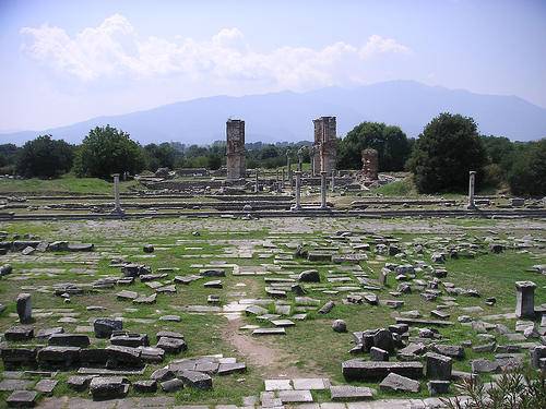
3. Roman Forum (Agora) and
Via Egnatia
At the heart of Roman Philippi lies the grand Forum,
constructed in the 2nd century CE (during the reign of Marcus
Aurelius) as the administrative, commercial, and civic center. This
vast rectangular plaza was surrounded by porticoes, shops, public
buildings, a basilica (law court), and a monumental terrace with
temples to the north. Colorful mosaic floors, column bases, and
paved surfaces are still visible, along with inscriptions and
architectural fragments that evoke its former grandeur as a “small
Rome” in the eastern provinces.
The Via Egnatia—the ancient
highway—runs directly through the site, bisecting the Forum and
connecting the city to major centers like Thessaloniki and
Constantinople. You can walk along preserved sections of this road,
imagining Roman legions, merchants, and pilgrims passing through.
Nearby are remains of latrines, baths, a palaestra (wrestling
school), and a cistern.
4. Early Christian Basilicas and the
Octagon Complex
Philippi’s transformation into a Christian
pilgrimage center is evident in its grand basilicas (4th–6th
centuries CE), built atop earlier Roman structures and among the
best-preserved examples of Early Christian architecture in the
Balkans.
Basilica A (northern slope, late 5th century): The
largest church in Philippi, a three-aisled basilica with an atrium,
galleries, marble paving, frescoes, and a baptismal font. It was
destroyed by a major earthquake around 619 CE and never rebuilt.
Scattered architectural elements and foundations remain.
Basilica
B (south of the Forum, mid-6th century): The most visually striking
ruin, with tall surviving pillars, arches, and brickwork in an
experimental domed/transept style influenced by Constantinopolitan
architecture (similar to Hagia Irene). Its ruins were among the
first visible before modern excavations and appear in historical
engravings. Recent restoration work has stabilized parts of the
superstructure.
Octagon Church (Octagonal Basilica) Complex:
Dedicated to the Apostle Paul (the city’s first bishopric
cathedral), this sophisticated 4th–6th century ecclesiastical center
includes the distinctive octagonal church, atrium, baptistery,
mosaics, and the “Bishop’s Palace.” It was built over Roman-era
buildings and served as the metropolitan seat. The octagonal plan is
rare and architecturally innovative; protective roofing now covers
sensitive areas.
A traditional (though debated) site identified
as Saint Paul’s Prison—a Roman cistern or cell near the Forum—is
also signposted and tied to the biblical account in Acts 16.
5. Additional Features and the Archaeological Museum
Other
notable elements include the Hellenistic funerary heroon (hero
shrine/temple), rock sanctuaries, and scattered public buildings
like workshops and thermal baths uncovered in recent excavations.
On-site, the modern Archaeological Museum of Philippi houses
artifacts from the city (tombs, inscriptions, sculptures, and
everyday objects) spanning its full history, providing essential
context.
The site is open to visitors (with a small entrance fee)
and can be explored in 2–3 hours on foot via paths. It remains
partially active for archaeology, with ongoing conservation (e.g.,
fire safety and Basilica B restoration).
By Air (Recommended for International Travelers)
The most
practical entry points are the two nearby airports:
Kavala
International Airport "Megas Alexandros" (KVA): The closest, about
26–30 km / 20–45 minutes away (depending on exact routing). Direct
flights from Athens (around 1 hour 10 minutes) and some seasonal
international/charter routes.
From the airport: Taxi (around
€25–40, 20–30 minutes), private transfer, or bus (to Chrysoupoli
then connect; less direct). Airport buses may run to Kavala city
center first.
Many visitors fly into Kavala for a quick onward
trip.
Thessaloniki International Airport "Makedonia" (SKG):
Larger hub with many international and domestic flights (about
127–160 km away, 1.5–2 hours drive).
From here, rent a car, take
a bus to Kavala (then connect), or arrange a private transfer/driver
(popular for day trips).
Other distant options include Athens
(long bus/train + connections) or Alexandroupolis, but these are
less efficient.
By Car (Most Flexible Option)
Driving is
straightforward and recommended for exploring the site and nearby
areas (Kavala, Drama, or St. Lydia's Baptistery).
From Kavala:
15–16 km, 20–25 minutes via the main Kavala-Drama road
(well-signposted turnoff to the site).
From Thessaloniki: ~150
km, about 1 hour 45–2 hours via Egnatia Odos (A2 motorway, tolls
apply).
From Athens: 6–7+ hours (with tolls); not ideal as a
direct drive—better to fly first.
Parking: Large lot at the
site entrance (suitable even for campers/RVs). The site spans both
sides of the old road.
Rentals are available at airports or in
major cities. Roads are good, but drive carefully in rural areas.
By Public Bus (Budget-Friendly)
Greece’s KTEL regional buses
are reliable and affordable.
From Kavala: Frequent buses to
Drama stop at/near Krinides (by the Philippi site). Tell the driver
“Philippi archaeological site” or “Krinides.” Journey: ~30–40
minutes, every 30–60 minutes (more frequent weekdays). Tickets
bought at the station or on board; cheap (~€2–4). Last buses return
in the evening.
Kavala bus station (KTEL Kavala) is central;
check schedules on ktelkavalas.gr (Greek site, but useful for
times).
From Thessaloniki: Direct or via Kavala (2–2.5 hours
to Kavala, then short connection). Total ~3.5–4 hours. KTEL
Macedonia buses run regularly.
From Athens: Long direct or
semi-direct KTEL Kavala buses (~8–10 hours, €50–80). Or train to
Thessaloniki then bus.
Buses drop near the entrance; the site is
walkable from there.
By Train
Limited options.
Thessaloniki to Drama (then bus/taxi to Philippi, ~25 km from
Drama). Slower and less convenient than bus (~5 hours total from
Thessaloniki).
Private Transfers, Taxis, and Tours
Taxis/Private Drivers: Readily available from Kavala (~€25 one-way),
airport, or Thessaloniki. Companies like Philippi Taxi offer
airport/port transfers and sightseeing.
Organized Tours/Day
Trips: Very popular from Thessaloniki or Kavala (often include
Kavala old town, St. Lydia’s Baptistery, and a guide). Private or
small-group options with hotel pickup are ideal if you want context
without hassle. Cruise port arrivals in Kavala often offer these.
At the Site
Hours: Typically 8:00–20:00 (summer) or
8:30–15:30 (winter); confirm as they vary. Closed on some holidays.
Tickets: Around €6–10 (includes museum combo options); reduced for
certain groups/seasons.
Time Needed: 2–3 hours to explore fully
(theater, basilicas, forum, prison of St. Paul, acropolis climb for
views). Flat paths mostly, but some uneven terrain and sun
exposure—wear hat, sunscreen, comfortable shoes, and bring water.
Nearby: Archaeological Museum of Philippi, St. Lydia’s Baptistery
(short distance), Krinides village for food.
Practical Tips
Best Base: Kavala (charming, port town) for proximity or
Thessaloniki for more amenities/flights.
Season: Spring/fall
ideal (milder weather); summer hot and sunny—visit early/late. Site
has limited shade.
Combinations: Pair with Kavala (old town,
castle), Drama, or a Via Egnatia route.
Accessibility: Museum is
better for mobility needs; site is mostly outdoors and expansive.
Currency/Language: Euros; English widely understood in tourist
areas, but basic Greek helps for buses.
Always check current
schedules on Rome2Rio, KTEL sites, or Google Maps, as they can
change seasonally.
What to See: Key Highlights and Self-Guided Walking Tour
The site
spans both sides of the modern road (about 2 km of walking, mostly
flat but on uneven ancient stones/paths). Plan 2–3 hours for the
main ruins plus museum. A logical route starts near the entrance:
Theatre (4th century BC, Philip II era): Hellenistic origins,
Roman expansions for gladiatorial games (added arena, animal
chambers). Still used for summer performances in the Philippi
Festival.
Basilica A (5th century AD): Early Christian basilica
destroyed by earthquake.
Paul’s Prison (traditional site): Likely
a Roman cistern later used as a chapel; fresco remnants visible.
Symbolic for pilgrims.
Roman Forum (Agora): 2nd century AD
administrative/commercial center along Via Egnatia. Paved sections,
shops, temples, and Latin inscriptions remain.
Basilica B
(Direkler): Massive 6th-century pillars; collapsed during
construction.
Octagon Complex / Basilica of Paul: Key Early
Christian site with 4th–5th century church dedicated to Paul;
octagonal design, mosaics.
Via Egnatia traces: Ancient Roman road
paving visible.
Archaeological Museum of Philippi (near
entrance): Excellent collection of prehistoric to Roman artifacts
(sculptures, coins, jewelry) on the ground floor; Christian-era
items upstairs. Modern, accessible, with elevator.
Nearby:
Baptistery of Saint Lydia (1–2 km away, free, in the hamlet of
Lydia): Modern octagonal church (1970s) with vibrant mosaics
depicting Paul’s story. Outdoor riverside baptistery on the Zygaktis
River marks Lydia’s baptism site (first Christian in Europe).
Peaceful, pilgrim-friendly spot with shop/cafe. Combine easily with
the main site.
Other nearby: Dikili Tash prehistoric mound
(Neolithic finds); Krinides Mud Baths (therapeutic clay/spa
experience).
Practical Visiting Tips
Opening Hours
(approximate; confirm via official Odysseus site as they vary
seasonally): Site and museum generally 8:00/8:30 AM–3:30/8:00 PM or
later in summer (longer June–Aug); shorter in winter. Closed
Tuesdays in some periods or national holidays.
Tickets (as of
recent updates): Around €10 for the site and €10 for the museum
(separate; combined ~€20). Reduced rates for seniors/students; check
for free days or winter discounts. Prices standardized in recent
years.
Best Time to Visit: Shoulder seasons (late April–June or
September–October) for mild weather (20–25°C), fewer people, and
pleasant countryside. Avoid midday summer heat (can hit 32°C+ with
little shade). Early morning is ideal for light and solitude. Winter
visits are possible but cooler/damper.
What to Wear/Bring:
Comfortable, sturdy walking shoes (uneven terrain). Hat, sunscreen,
water (exposed site), light layers. Umbrella possible for rain. No
major accessibility issues at the museum; site is partially
challenging for mobility.
Weather/Other: Check forecasts. Little
shade—hydrate. Download a map or use QR codes on-site for info.
Guided tours (local licensed guides) enhance understanding,
especially for biblical/history context.
Where to Stay and
Eat
Base in Kavala for amenities (hotels, restaurants, nightlife)
or quieter Krinides (e.g., Philippeio Hotel). Limited options right
at Philippi.
Eat at site cafe or nearby tavernas in
Krinides/Kavala for fresh Greek fare (souvlaki, seafood, local
wines). Philippi area has reasonable prices (€10–25/meal).
Additional Tips for an Enjoyable Visit
For Pilgrims: Strong
biblical tie—focus on Paul/Lydia sites; ceremonies sometimes held.
Families/Accessibility: Kid-friendly open space; museum engaging.
Combine with More: Mud baths, Drama (caves, parks), wineries, or Via
Egnatia remnants.
Sustainability: Stick to paths; site is active
archaeologically in parts.
Current Info: Verify hours/tickets on
odysseus.culture.gr or local tourism sites, as details can shift.
Philippi (Ancient Greek: Φίλιπποι, Phílippoi; modern Greek: Φίλιπποι,
Fílippoi) is one of the most historically significant archaeological
sites in northern Greece, located about 13 km northwest of modern Kavala
(ancient Neapolis) in the region of Eastern Macedonia and Thrace.
Situated at the foot of Mount Orbelos (now Mount Lekani), it overlooked
a once-marshy plain bordering the Pangaion Hills, with strategic control
over the route linking Amphipolis to the Aegean coast. The site
controlled key east-west passages and nearby gold and silver mines,
making it valuable across eras. Today, the ruins form a UNESCO World
Heritage Site (inscribed 2016), showcasing an exceptional layered
history spanning Hellenistic, Roman, and early Christian periods. The
city was founded in the 4th century BC, flourished as a Roman colony
dubbed a “small Rome,” became the birthplace of Christianity in Europe,
and was abandoned in the 14th century after the Ottoman conquest.
Nearby Dikili Tash (about 1.5 km east) reveals prehistoric occupation
from the Neolithic period (around the 6th millennium BC, possibly as
early as 6400 BC) through the Bronze Age (to ~1100 BC), indicating
long-term human presence in the fertile region, though the classical
city of Philippi itself dates from the mid-4th century BC.
Foundation as Crenides (c. 360–356 BC)
Thasian colonists (from the
island of Thasos, with Athenian support led by Kallistratos) established
the settlement around 360/359 BC, originally named Crenides (Κρηνῖδες,
“the Fountains” or “Springs”) or sometimes Datum/Datos, due to abundant
water sources. It was a modest colony on the northern edge of a marshy
plain, aimed at exploiting nearby mineral resources amid tensions with
local Thracian tribes.
In 356 BC, the Thasians, facing Thracian
attacks, sought aid from Philip II of Macedon (father of Alexander the
Great). Philip intervened, conquered the site, enlarged and refortified
it with strong walls (partially blocking the marsh-Mount Orbelos
passage), partially drained the swamps for agriculture, and renamed it
Philippi after himself. He sent Macedonian colonists, established a
mint, and exploited new gold mines (e.g., at Asyla), which produced
significant wealth—reportedly up to 1,000 talents annually in some
accounts. The city retained some autonomy as a “free city” with its own
Greek institutions (like the Assembly of the demos) within the
Macedonian kingdom.
Hellenistic remains from this era include parts
of the original city walls (large marble blocks with square towers and
gates), the first phase of the theater (one of Greece’s largest at the
time), and a heroön (funerary temple/shrine) possibly dedicated to the
city’s founder-hero Exekestos, located near the agora.
Roman
Period and the Battle of Philippi (168 BC–1st century AD)
Rome
conquered Macedonia in the Third Macedonian War (171–168 BC), defeating
the Antigonids at Pydna in 168 BC and dividing the kingdom into four
districts (merides). Philippi fell into the eastern district (initially
with Amphipolis as capital). By the mid-2nd century BC, as part of the
Roman province of Macedonia, the city gained new importance when the
Romans reconstructed the old royal road as the Via Egnatia, a vital
artery linking the Adriatic to the East (Europe to Asia). This boosted
trade, commerce, and military movement.
The city’s most famous event
occurred in October 42 BC: the Battle of Philippi, the final major clash
of the Liberators’ civil war following Julius Caesar’s assassination.
Forces of the Second Triumvirate—Mark Antony and Octavian (later
Augustus)—defeated the Republican army led by Brutus and Cassius
(Caesar’s assassins). The two-day battle on the plain west of the city
involved massive armies (around 100,000–110,000 men per side). Antony’s
troops broke Cassius’s camp (leading to his suicide); three weeks later,
Brutus was defeated and also took his own life. Casualties were heavy
(tens of thousands). This victory effectively ended meaningful
Republican resistance and paved the way for the Roman Empire.
Post-battle, Philippi was refounded as a Roman colony (Colonia Victrix
Philippensium), settled with veterans (initially from Legion XXVIII,
later reinforced). Octavian/Augustus further reorganized it around 30–27
BC as Colonia Iulia (Augusta) Philippensis, granting it “Italic right”
and centuriating surrounding land for settlers (including Italians,
veterans, Thracians, Greeks, and a small Jewish community). It became a
“small Rome” in miniature, with Latin as the dominant language in
official inscriptions, governed by Roman-style duumviri magistrates. The
population mixed, and the city prospered from mines, agriculture, and
its position on the Via Egnatia.
Roman additions transformed the
urban layout: a large forum (laid out in terraces along the Via Egnatia,
expanded under emperors like Claudius and Antoninus Pius), a basilica,
shops, a monumental terrace with temples, and modifications to the
theater for gladiatorial games and spectacles.
Early Christian
Era and Paul’s Visit (1st–4th centuries AD)
Philippi holds immense
significance in Christian history as the site of Europe’s first
Christian community. In 49/50 AD, during his second missionary journey,
the Apostle Paul (accompanied by Silas, Timothy, and possibly Luke)
crossed from Asia Minor to Europe after a vision of a “man of Macedonia”
(Acts 16:9–10). Landing at Neapolis, he traveled to Philippi—a Roman
colony with a small Jewish presence.
Key events (Acts 16):
Paul preached by the river; Lydia of Thyatira (a purple cloth dealer and
“worshiper of God”) became the first recorded European convert and
hosted the missionaries.
He exorcised a spirit of divination from a
slave girl, leading to his and Silas’s arrest, beating, and
imprisonment.
An earthquake opened the prison doors; the jailer
converted after Paul and Silas refused to escape.
Paul and Silas were
released after revealing their Roman citizenship.
Paul visited
again on his third journey (~56–57 AD). The church he founded remained
loyal and supportive (e.g., sending aid during his later imprisonment).
Paul’s Epistle to the Philippians (written c. 61–62 AD, likely from
Rome) is one of the warmest and most joyful New Testament letters,
addressing unity, joy in suffering, and thanks to the community. It
mentions figures like Euodia, Syntyche, and Epaphroditus.
Christianity grew rapidly here. The earliest church (a small
prayer-house, later the “Basilica of Paul”) dates to the 4th century,
with a mosaic inscription. By the 4th–6th centuries, at least seven
churches were built, including large basilicas rivaling those in
Thessaloniki or Constantinople. Philippi became an episcopal see and
pilgrimage center.
Byzantine Period, Decline, and Abandonment
(4th–14th centuries)
Philippi continued as a prosperous Byzantine
city and garrison on the Via Egnatia, with rebuilt fortifications (e.g.,
under Emperor Nicephorus II Phocas c. 969 and Bishop Basil in 1077). It
produced wine and served as a commercial center (noted by Arab
geographer Al-Idrisi c. 1150). Brief occupations occurred (Bulgarians in
838, Franks after the Fourth Crusade in 1204, Serbs later).
Decline
set in due to Slavic invasions (late 6th century, ruining agriculture),
the Plague of Justinian (547), and a devastating earthquake c. 619 AD
that destroyed much of the city. It shrank to a village but retained
some military importance. By the 14th century, following Ottoman
advances in the Balkans, Philippi was abandoned. French traveler Pierre
Belon (1540s) described only ruins used as quarries. The name survived
in nearby villages.
Archaeology and Modern Significance
Excavations began in 1914 by the French School of Athens (interrupted by
WWI, resumed later) and continue under Greek authorities. Key visible
monuments include:
Hellenistic: Walls, gates, acropolis
fortifications, theater, heroön.
Roman: Expansive forum, Via Egnatia
sections, modified theater/arena.
Christian/Byzantine: Multiple
basilicas (e.g., Octagonal Church linked to Paul with mosaics; Basilica
A, the largest; Basilica B with dome), bishop’s residence, and later
walls.
The site exemplifies the transition from Hellenistic
garrison town to Roman colony to early Christian center, meeting UNESCO
criteria for outstanding testimony to Roman imperial architecture and
early Christianity.
Regional Setting and Topography
Philippi occupies a strategic
position in the Drama Basin (also called the Philippi Plain or plain of
Drama), a large intramontane tectonic basin (roughly 2,300 km²) at the
southeastern edge of the plain. The basin floor sits at low elevation,
around 40–80 m above sea level, while the modern village of Filippoi is
at about 78–181 m. The ancient city itself was founded on the northern
border of this plain, at the foot of a prominent rocky hill that served
as its acropolis (approximately 265 m elevation). This hill provided a
defensible high point overlooking the low-lying plain to the south.
The basin is dramatically enclosed by mountain ranges that create a
natural amphitheater-like setting and influence local climate and
hydrology:
North and northeast: Mount Lekani (ancient Mount
Orbelos, ~1,296 m), against whose foothills the city was built. The
acropolis and city walls (total perimeter ~3.5 km) originated from the
hill’s peak and extended down the slopes to enclose foothills and part
of the plain.
West: Mount Falakro (Phalakron, up to ~2,233 m).
South: Pangaion Mountains/Hills (~1,956 m), which historically separated
the marshy plain from the coast.
East/southeast and additional
ridges: Mount Symvolon and Menikion ranges.
This topography made
Philippi a natural control point for the passage between the mountains
and the plain, as well as for routes toward Amphipolis and the gold
mines in the surrounding hills (particularly around Mount Pangaion).
Hydrology and the Philippi Peatland
The area’s name
origin—Crenides (“springs” or “fountains”)—reflects abundant karst
springs and water sources. In antiquity, an extensive marsh or swamp
covered much of the plain south of the city, stretching toward the
Pangaion Hills. Philip II of Macedon (who renamed and fortified the
settlement in 356 BCE) partially drained this marsh to make the land
more usable and to support mining and colonization.
The most
distinctive hydrological feature is the Philippi peatland (Tenaghi
Philippon or Tenagi Philippon), one of Greece’s largest and most
significant wetlands. Before large-scale drainage in the 1940s, the mire
covered up to ~274 km² (with a core peatland area of ~55 km²). It is an
alkaline peat bog—one of the deepest in the world, with peat and limnic
sediments reaching thicknesses of 190–300 m (average ~75 m) and a
paleoenvironmental record spanning ~1.35 million years. This makes it a
globally important climate archive. The peatland is fed by groundwater,
mountain runoff, and karstic springs; it drains via streams (including
the Angitis/Gangites or Zygactes River) into a tributary of the Strymon
River and ultimately the northern Aegean Sea.
Post-drainage, the area
became highly productive farmland, though intensive cultivation has
caused soil subsidence and periodic flooding issues due to the
underlying peat.
Climate
The Drama Basin experiences a
transitional Mediterranean climate with strong continental influences,
shaped by its enclosed topography, elevation, and surrounding high
mountains. Cold air pools in the basin, katabatic winds descend from the
slopes, and nocturnal radiation contributes to lower temperatures than
coastal areas experience. Frost and occasional snow are more common here
than in typical Greek lowlands.
Approximate data (based on nearby
Drama station records):
Mean annual temperature: ~16°C.
Summer
(July): average highs ~27°C.
Winter (January): average ~5°C.
Annual precipitation: ~520 mm, with a Mediterranean pattern—wetter in
autumn and winter (peak in December), very dry summers (August/September
often <30 mm). Higher elevations in the surrounding mountains receive
significantly more rain/snow (up to ~1,100 mm).
This climate
supported agriculture in the plain while the mountains provided timber,
minerals, and summer pastures.
Geology, Resources, and Modern
Landscape
Geologically, the basin is a tectonic graben filled with
thick Quaternary sediments, including the massive peat deposits. The
surrounding mountains are part of the Rhodope Massif and related
formations, rich in minerals—most famously gold deposits that drew
Thasian colonists and later Philip II.
Today, the Philippi Plain is
one of Greece’s most fertile agricultural zones (“breadbasket” areas),
producing cotton, wheat, maize, tobacco, sugar beets, kiwi, and olives.
The archaeological site itself (a UNESCO World Heritage Site covering
~87.5 ha with a buffer zone) sits amid this farmland, with ruins
spreading from the acropolis hill across the stable foothill ground into
the former marsh edge.