Location: Crete Island
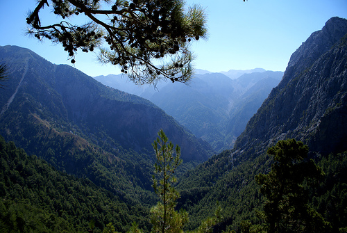
Samaria Gorge, located in the southwestern part of Crete, Greece, is one of Europe's most spectacular natural wonders and a UNESCO Biosphere Reserve. Stretching approximately 13-16 km (depending on the measurement: 13 km through the national park proper, plus an additional 3 km to the coastal village), it carves through the rugged White Mountains (Lefka Ori), descending from an elevation of about 1,230 meters at the Xyloskalo trailhead on the Omalos Plateau down to sea level at Agia Roumeli on the Libyan Sea. Often hailed as the continent's longest gorge (though some sources note France's Gorges du Verdon exceeds 20 km), it features dramatic landscapes with towering cliffs, a winding riverbed, and diverse ecosystems that make it a haven for hikers and nature enthusiasts. Established as a national park in 1962, it attracts up to 2,000 visitors per day during peak season, yet its vast scale allows for a sense of solitude if timed well. The gorge is not just a geological marvel but also a symbol of Cretan resilience, serving historically as a refuge during conflicts.
Step 1: Getting to Crete
By Air: Fly into Chania International
Airport (CHQ), the closest major airport (about 1 hour from the gorge
entrance). Heraklion International Airport (HER) is an alternative but
farther (about 3-4 hours by car or bus). Direct flights are available
from many European cities, especially in summer.
By Ferry: From
mainland Greece (e.g., Piraeus port in Athens), take a high-speed ferry
to Chania or Heraklion (operated by companies like Minoan Lines or ANEK;
journey time 4-9 hours depending on the route).
Chania serves as
the primary base for most visitors due to its proximity.
Step 2:
From Chania (or Other Parts of Crete) to the Gorge Entrance (Xyloskalo)
Options include public bus (most budget-friendly and convenient for the
one-way hike), car rental, or organized tours. The gorge hike is 16 km
one-way downhill (taking 5-7 hours for most hikers), ending at Agia
Roumeli on the Libyan Sea coast, so plan for return logistics
accordingly.
By Public Bus (KTEL): Recommended for independent
travelers. Buses run daily during the season from Chania's central bus
station to Xyloskalo.
Departure times: 5:00 AM, 7:45 AM, and 8:45 AM.
Journey time: About 1 hour.
Fare: Approximately €7-8 one-way (buy
tickets at the station; English-speaking staff available).
Tip: Take
an early bus (e.g., 7:45 AM) to start hiking by 9:00 AM and avoid
crowds/heat. Buy a combined bus + ferry ticket at the station for the
full loop (around €30 total per adult for round-trip transport). Buses
are comfortable and reliable, but arrive early as they may depart a
minute or two ahead of schedule.
By Car Rental: For flexibility,
rent a car from Chania airport or city center (agencies like Hertz or
local options; expect €30-50/day). Drive south via the E75 highway, then
follow signs to Omalos/Xyloskalo (winding mountain roads, about 1 hour).
Parking at the entrance costs €5/day. However, since the hike is
one-way, you'll need to arrange a return to your car—either by bus from
Sougia (departs 7:00 AM or 18:15 PM after the ferry) or a taxi
(expensive, €100+).
By Organized Tour: Book a guided day trip from
Chania, Rethymno, or Heraklion (via GetYourGuide or local agencies;
€40-60/person including transport). Tours handle bus transfers to/from
the entrance and return via ferry/bus, often with a guide for the hike.
From Other Areas: If starting from Rethymno or Heraklion, take an
intercity KTEL bus to Chania first (1-2 hours, €8-15), then transfer to
the Omalos bus.
Key Logistics for the Visit
Entry Fee: €10 per
person (pay at the Xyloskalo entrance; keep your ticket as it's checked
at the exit).
Opening Hours: Gates open around 7:00 AM; last entry
typically by 4:00 PM, and all visitors must exit by 6:00 PM. Start early
to allow time for the hike.
What to Bring: Sturdy hiking shoes, water
(refill stations along the trail), snacks/lunch, hat, sunscreen, and
swimsuit (for a dip in Agia Roumeli). The trail is well-maintained with
rest areas, but it's rocky and steep in parts—no pets or bikes allowed.
Returning After the Hike
The hike ends in Agia Roumeli (no road
access), so take a ferry east along the coast, then a bus back.
Ferry from Agia Roumeli: Operated by ANENDYK; departs daily at 5:30 PM
during the season to Sougia (40 minutes, €13) or Hora Sfakion (1 hour,
€15). Buy tickets in advance with your bus ticket or at the Agia Roumeli
dock (no advance booking needed, but confirm schedules as they can
change).
Bus Back:
From Sougia: To Chania at 6:15 PM (after
ferry arrival; €8, 1.5 hours) or to Xyloskalo/Omalos at 6:15 PM if
retrieving a car.
From Hora Sfakion: To Chania at 6:30 PM (after
ferry; €11, 2 hours).
Alternative: Stay overnight in Agia Roumeli
or Loutro (a stop on some ferries) for a relaxed pace, then ferry/bus
the next day.
Season, Opening Hours, and Fees (as of 2025–2026)
Open: Typically
May 1 to October 31 (weather-dependent; may open later or close early
due to rain, wind, or flash flood risk). Check conditions the day
before.
Hours: Roughly 7 AM–4 PM entry (exact times vary; last full
entry often 1–3 PM to ensure exit before dark). Rangers monitor for
safety.
Entrance fee: €10 per adult (cash or card; buy online in
advance via samaria-tickets.necca.gov.gr if available). Free for
children under 15–18 (show ID) and often seniors 65+. Keep your ticket
for exit check.
Closures: Common in bad weather (wind, rain). Boats
from Agia Roumeli can also cancel in high winds, stranding hikers
overnight.
Best time to visit: May–June (cooler, wildflowers
blooming, possible water in streams) or September–early October (fewer
crowds, milder heat). July–August is hottest and busiest (up to
thousands daily).
Difficulty and Duration
Moderate to
challenging for most fit hikers. The first 4–5 km is a steep, zigzagging
rocky descent (tough on knees). The middle section has flatter riverbed
walking with crossings. The final stretch opens up before the "Iron
Gates" (narrowest point with sheer cliffs). Some small uphill parts
exist.
Time: 5–7 hours for the full hike (faster for strong hikers,
slower with photo stops/rests). Add time for the final walk/shuttle to
the beach/port.
Not suitable for young children, those with
knee/ankle issues, or poor fitness without preparation. Hiking poles are
highly recommended.
Getting There and Logistics
Standard route
(north to south, Xyloskalo to Agia Roumeli):
From Chania (most common
base): Early KTEL bus (~6:15 AM, ~1 hour, ~€7–8). Arrive early for
ticket/breakfast.
By car: Drive to Omalos/Xyloskalo (~1 hour from
Chania). Parking available (fee sometimes applies). Not ideal for return
(you'll need to retrieve the car via Sougia bus/taxi).
Organized
tour: Easiest for logistics (bus, guide, entrance, ferry included). Good
for first-timers but crowded.
At the end: Ferry from Agia Roumeli
to Chora Sfakion (~1 hr), Sougia (~40 min), or Paleochora. Then bus back
to Chania (ferry schedules align with buses). Last ferries often ~5:30
PM—don't miss them.
Alternatives:
Short hike from Agia Roumeli
(boat in, hike to Iron Gates ~1.5–2 km, boat out)—easier, flatter, great
for families or knee concerns.
Overnight in Agia Roumeli or Omalos
for a relaxed pace.
What to Bring (Packing List)
Footwear:
Sturdy hiking boots or trail shoes with good grip and ankle support
(trainers possible but risky on rocks; many regret it).
Water: 1–2
liters start; refill at springs/spigots (drinkable, but check if dry in
late summer).
Snacks/food: Picnic lunch, energy bars, nuts, fruit—no
shops inside. Cafe at entrance for breakfast/coffee.
Clothing: Layers
(cool at top, hot lower down), hat, sunglasses, sunscreen, light rain
jacket, swimsuit/towel (for beach at end).
Other essentials: Hiking
poles, small backpack, cash (toilet at entrance, possible extras),
headlamp (if late), personal meds, toilet paper/wipes, trash bag (Leave
No Trace).
Optional: Camera/binoculars for wildlife/views,
electrolyte tablets.
Do not bring: Heavy bags, alcohol, unnecessary
items—pack light to avoid fatigue/injury.
On the Trail: Tips for
a Safe, Enjoyable Hike
Start early — Beat crowds and heat. The trail
gets busy quickly.
Pace yourself — Steep start; take breaks at
viewpoints, old village of Samaria (restrooms, water, first aid), and
rest areas. Follow signs/rangers.
Terrain — Rocky, some stream
crossings (stepping stones/bridges). Watch for loose rocks, slippery
areas when wet. Stay on the marked path.
Wildlife & nature — Spot
kri-kri goats (bold but don't feed), birds, flowers. No swimming in
rivers/streams. No littering, fires, smoking (only designated spots), or
disturbing plants/animals.
Toilets — Available at key points (some
basic/squat; bring TP).
Safety — Emergency 112. Report issues to
rangers. Knees take a beating on descent—poles help. In heat, hydrate
and rest in shade.
Photos — Plenty of spots; the Iron Gates
(Portes/Sideroporta) are iconic.
After the Hike
Agia Roumeli:
Pebbly beach for a swim/relax (cold, refreshing water). Tavernas for
food/drinks. Simple guesthouses if staying over.
Return — Ferries can
be crowded; book if possible. Buses from drop-off points wait for
ferries.
Additional Tips
Fitness prep: Train with downhill
walks if possible. Listen to your body—turn back if needed (short
sections allowed early/late).
Crowds: Very busy in peak season; early
start or shoulder months help.
Accessibility: Not
wheelchair-friendly; mules sometimes used for rescues.
Sustainability: Support the park with your fee (path maintenance, etc.).
Respect rules strictly.
Check updates: Official sites like samaria.gr
or samaria-gorge.gr for real-time info. Apps like Maps.me or AllTrails
for offline maps.
The one-way hike is a demanding 16 km descent on rough, rocky terrain, typically taking 5-8 hours (or 3 for experienced hikers), requiring good fitness and sturdy footwear. It begins with steep switchbacks at Xyloskalo, passes the Agios Nikolaos chapel, the abandoned Samaria village (with a doctor on-site), and culminates at the Gates before flattening toward Agia Roumeli. The path crosses the stream multiple times via bridges or rock-hopping, with rest stops, springs for water, toilets, and wardens for assistance (including mules for the injured). Open from early May to late October (potentially closing for rain or repairs), entry costs €10 (free for under-18s and over-65s), with tickets available online. Best visited in spring for wildflowers and milder weather; start early (dawn) or late morning to avoid crowds and optimize shade. Organized tours from Chania handle logistics, including buses to Omalos and ferries from Agia Roumeli to Chora Sfakion. Pack essentials: hiking shoes with ankle support, hat, sunscreen, snacks, minimal water (refill at springs), and swimwear for the beach finale. Warnings include rockfall risks on rainy days, no overnight stays, and the need to exit before dark—tickets are checked to ensure safety. For a shorter option, ferry to Agia Roumeli and hike uphill 2-3 km into the gorge.
Location and Regional Context
The gorge lies in the heart of the
Lefka Ori massif, between the Omalos Plateau to the north and the Libyan
Sea to the south. It runs roughly north–south for about 16 km (the
hiking trail through the national park is typically described as 13 km
from the entrance to the old village of Samaria, plus another 2–3 km to
the coastal village of Agia Roumeli, for a total walking distance of
around 15–18 km depending on the exact starting point). The surrounding
mountains include over 50 peaks exceeding 2,000 m, with the highest,
Pachnes, reaching 2,453 m. The gorge itself is flanked by Mt. Volakias
to the east and the main Lefka Ori ridges to the west. From Agia Roumeli
at the southern exit, the southernmost point of Europe (Gavdos island)
is visible on the horizon.
The park covers approximately 58,400
hectares (with a small marine component), encompassing the gorge, side
ravines, high plateaus, and coastal areas. Elevations range from sea
level at the Libyan Sea outlet to over 2,400 m on the surrounding peaks
(the park’s average elevation is around 953 m).
Topography and
Dimensions
The trail begins at the northern entrance, Xyloskalo
(“wooden staircase”), on the edge of the Omalos Plateau at approximately
1,230–1,250 m above sea level. From there, it descends steeply (over
1,000 m vertical drop in the first few kilometers) through switchbacks
into the gorge proper. The landscape transitions from high-mountain pine
and cypress forest to sheer limestone cliffs, a boulder-strewn riverbed,
and finally a coastal plain.
Key dimensions:
Length: 16 km
(gorge proper) / 13 km main park trail section.
Width: Varies
dramatically from ~150 m at its widest to just 3–4 m at the famous
narrowest point, known as the Gates (Portes or “Iron Gates”).
Height
of walls: At the Gates, the near-vertical cliffs soar up to nearly 300 m
(some descriptions note sections approaching 500 m in the broader gorge
system). Overall relief in the park reaches over 2,400 m from sea level
to the highest summits.
The topography is highly dissected:
steep, near-vertical rock faces, deep karstic depressions, scree slopes,
and numerous side gorges. The initial descent from Xyloskalo is
dramatic, with panoramic views of the White Mountains’ snow-dusted or
sun-bleached limestone ridges.
Geological Formation and Structure
The Samaria Gorge is a classic example of fluvial erosion combined with
tectonic uplift and karst processes in a limestone-dominated terrain.
Its rocks belong primarily to two main geological units:
Plattenkalk Group (the dominant and thickest unit in Crete): Thinly
bedded, platy marbles and limestones with chert nodules and
intercalations (often containing fossil diatoms and sponges from ~180
million years ago). These form the central and lower parts of the gorge.
Trypali Unit (more localized to western Crete): White recrystallized
limestones/marble and conglomeratic limestone with solution holes,
appearing at the upper entrance (Xyloskalo) and summits.
Additional layers include Gigilos schists (yellowish with sandstone) and
stromatolitic dolomites (dark, iron-striped rocks formed by ancient
microbial activity).
Formation timeline and processes:
The
bedrock originated as marine sediments hundreds of millions of years ago
(Mesozoic era).
Tectonic compression from the African plate pushing
against the European plate (ongoing since the Miocene, ~25 million years
ago) caused uplift, folding, faulting, and metamorphism. This began
accelerating ~13 million years ago and intensified in the last 5 million
years, raising the Lefka Ori dramatically.
During the Quaternary
period (last ~2.6 million years), a small river (the Tarraios or similar
seasonal stream) exploited faults and fractures, carving the gorge
through differential erosion. Karstic dissolution of calcium carbonate
by acidic rainwater deepened the canyon, created caves (over 1,400
documented in the Lefka Ori, including some >1,000 m deep), springs (22
major ones), and poljes.
Glacial-interglacial cycles caused sea-level
fluctuations, further influencing erosion rates and forming marine
terraces visible near Agia Roumeli.
The result is a highly
karstified landscape with sinkholes, dolines, caves, and the deep,
narrow gorge perpendicular to major faults.
Hydrology and Climate
A seasonal river flows through the gorge (dry in summer, flowing in
winter/spring), fed by 22 springs and numerous torrents. Water emerges
from karst aquifers and creates clear, turquoise pools and small
waterfalls, especially in the lower sections. The riverbed becomes the
trail in many places, with wooden bridges crossing it.
The climate is
Mediterranean with strong orographic effects: high altitudes (up to
3,000 mm annual precipitation on the peaks) support cooler, wetter
conditions with winter snow, while the lower gorge and coast are hot and
dry in summer. Soils are generally thin and poor—mainly terra rossa (red
clayey soils from limestone dissolution)—limiting vegetation but
creating specialized microhabitats.
Ecology and Landscape
Features
The extreme altitude gradient (sea level to >2,000 m) and
isolation have produced exceptional biodiversity. Vegetation zones
include high-altitude cypress (Cupressus sempervirens) and pine (Pinus
brutia) forests, maquis, phrygana (shrublands with Pistacia and Cistus),
and chasmophytes (cliff-dwelling plants) in rock crevices. Roughly
one-third of Crete’s flora (hundreds of species, many endemic) occurs
here, including rare taxa like Zelkova abelicea and Anthemis
samariensis.
Fauna highlights include the iconic kri-kri (Cretan wild
goat, Capra aegagrus cretica), largely protected within the park, along
with endemic birds (e.g., golden eagle, bearded vulture), mammals
(Cretan badger, wildcat), and invertebrates. The gorge and surrounding
cliffs provide critical refuge.
Notable Features Along the Trail
Xyloskalo to Samaria village: Steep forested descent, passing ruins and
the old village (abandoned in 1962).
Mid-gorge: Riverbed walking,
side gorges, and increasing cliff height.
The Gates: Dramatic
narrowing—4 m wide with 300 m walls.
Exit to Agia Roumeli: Coastal
plain opening to the Libyan Sea beach.
Samaria Gorge (Φαράγγι Σαμαριάς), located in the White Mountains
(Lefká Óri) of southwestern Crete in Greece’s Chania regional unit, is
one of Europe’s longest gorges (approximately 16–18 km long) and a major
natural and cultural landmark. It stretches from the Omalos plateau at
about 1,250 m elevation down to the Libyan Sea at Agia Roumeli. Renowned
for its dramatic cliffs (reaching nearly 300–500 m high at the narrow
“Iron Gates” or Portes section, where the gorge squeezes to just 4 m
wide), it has been a National Park since 1962 and a UNESCO Biosphere
Reserve. While famous today as a world-class hiking destination, its
history spans geological deep time, prehistoric human presence, ancient
settlements and sanctuaries, medieval villages, and repeated use as a
“haven of freedom” during centuries of foreign occupation and revolts.
Geological Formation: Millions of Years in the Making
The gorge’s
formation is tied to Crete’s complex tectonic history. The rocks of the
Lefká Óri massif—primarily Mesozoic (225–140 million years ago) marble,
limestone, and dolomite—originated as sediments on the floor of the
ancient Tethys Sea. Tectonic convergence between the African and
European plates uplifted the region dramatically, especially in the last
million years (gaining roughly 1,000 m in altitude). Crete emerged as an
island around 8 million years ago during the late Miocene, with ongoing
uplift, subsidence, and sea-level changes during the Pliocene and
Pleistocene.
The Samaria Gorge itself formed during the Quaternary
period through a combination of karstic erosion (rainwater dissolving
calcium carbonate in the dolomite beds), fracturing from glacial action
and tectonics, and the erosive power of a small river flowing between
the White Mountains and Mt. Volakias. This created the steep, vertical
walls and deep gorges characteristic of the highly karstified Lefká Óri
(which features over 1,400 caves, including some of Greece’s deepest).
Fossils of ancient marine organisms (like diatoms and sponges from ~180
million years ago) are visible on the gorge’s rock faces today. Southern
Crete’s coastline has also risen relative to the north (about 3.65 m
higher), evident in ancient sea-level marks.
Prehistoric and
Ancient History: Sanctuaries, Cities, and Resource Exploitation
Humans have interacted with the gorge for thousands of years. Recent
finds suggest possible Paleolithic colonization, with more organized
habitation from the Early Iron Age onward. Permanent settlements likely
arose due to the gorge’s shelter, water sources, and defensibility in an
otherwise rugged landscape.
Key ancient sites include:
Ancient
Tarra (or Tara/Tarrha): Located at the southern exit near modern Agia
Roumeli, this was one of Homer’s “100 cities of Crete.” It dates back to
the Late Minoan period (evidenced by artifacts like a double-axe column
now in Chania’s museum) and flourished as an autonomous polis from the
Early Archaic period. It minted its own Hellenistic coins featuring a
bee and the head of the Cretan wild goat (kri-kri). Tarra had a major
temple to Apollo (possibly linked to a sanctuary at Agios Nikolaos
inside the gorge, where terracotta fragments and votive offerings have
been found). The city prospered in Greek, Roman, and early Byzantine
times, lying on key sea routes to Egypt. Its inhabitants exported
high-quality cypress wood from the gorge for shipbuilding and palace
construction (possibly supplying pillars for Knossos and Mycenae) and
engaged in trade and even piracy. Tarra declined after the 6th century
AD due to earthquakes, Arab raids, shifting trade routes, and the end of
major wheat shipments between Egypt, Rome, and Constantinople. It was
destroyed or severely damaged around 66 AD by coastal uplift.
Ancient
Kaino: Inside the gorge, this site was mythologically significant as the
reputed birthplace of the goddess Britomartis (an early Cretan form of
Artemis, associated with hunting and the wild).
Legends tie the area
to Apollo: one story holds that the god sought purification here from
the priest-healer Karmanor after slaying the Python at Delphi.
The gorge’s cypress forests provided valuable timber for Minoan,
Mycenaean, and later shipbuilders, linking it economically to Egypt and
the eastern Mediterranean.
Byzantine and Medieval Periods:
Village Founding and Early Refuge Role
The village of Samaria (inside
the gorge) was first inhabited in the Byzantine era, possibly around 900
AD during the Komnenos dynasty. It took its name from the ancient church
of Óssia María (Osia Maria or Saint Mary of Egypt), a 14th-century
Byzantine chapel dedicated to the 4th–5th-century saint (popularly
shortened to “Samaria”). A few Sfakian families lived there as
woodcutters and herders. The gorge’s isolation made it a natural refuge
even then.
Venetian Rule (13th–17th Centuries): Resistance and
Legends
Under Venetian control, the gorge sheltered freedom fighters.
A notable 14th-century incident involved the Skordilis family from
nearby Hora Sfakion: after a Venetian commander insulted a local woman
(“Chryssomaloussa”), the family avenged it by slaughtering the garrison.
Venetians tried but failed to enter the gorge to punish them, leading to
an uneasy truce. The woman reportedly became a nun at the Ossia Maria
convent. The gorge’s steep terrain repeatedly thwarted Venetian
incursions during revolts (e.g., after the failed 1570 uprising, when
Venetian authorities ordered destruction in Sfakia but couldn’t fully
penetrate Samaria).
Ottoman Period (1669–1898): A Haven of
Freedom
The gorge became legendary as a hideout during Cretan
uprisings against Ottoman rule. Its narrow passes and cliffs made it
nearly impregnable:
1770 (Daskalogiannis Revolt): About 4,000 women
and children fled into the gorge; defenders under Giannis Bonatos held
the Iron Gates, repelling Turkish forces.
1821 (Greek War of
Independence era): Defeated revolutionaries retreated here.
1866–1867
Revolt: Omalos plateau, Samaria, and Agia Roumeli served as rebel
strongholds and supply points. A provisional government formed in Agia
Roumeli. Ottoman forces under Mustafa Pasha bombarded the coast; in
1867, Omer Pasha landed 4,000 troops, but Cretans blockaded the gorge,
burned supplies to deny them to the enemy, and held out. The Turks
burned Agia Roumeli but never entered the gorge itself. An Ottoman
koules (fortress tower) was built at Agia Roumeli to control rebels.
20th Century: World War II and National Park Era
During the
German occupation of Crete in WWII, the gorge hid Cretan partisans and
Allied units (including radio operators relaying intelligence to Middle
East headquarters). Germans repeatedly failed to capture them. In May
1941, as German forces advanced, King George II of Greece and Prime
Minister Emmanouil Tsouderos hid in the abandoned or sparsely populated
Samaria village, issuing final orders before evacuating via Agia Roumeli
to a British destroyer bound for Egypt.
In 1962, the last ~30
inhabitants of the Samaria village (mostly woodcutters and their
families) were relocated to Agia Roumeli or elsewhere to establish the
National Park of Samaria. The primary goal was protecting the rare
kri-kri (Cretan wild goat, Capra aegagrus cretica), endemic flora/fauna,
and the gorge’s unique ecosystem. The park has since earned multiple
designations: UNESCO Man and the Biosphere Reserve (part of the World
Network), European Diploma of Protected Areas, Natura 2000 site, and
more. It opened to controlled tourism (May–October), with the famous
13–16 km hike from Xyloskalo to Agia Roumeli (followed by a boat ride
out). Permanent residence in the core was prohibited, but the area
remains culturally vital to local Sfakian communities.
Samaria Gorge (Farangi Samarias) in Crete, Greece, is the centerpiece
of Samaria National Park, a protected area in the White Mountains (Lefka
Ori) of western Crete. Declared a national park in 1962 primarily to
safeguard the endangered Cretan wild goat (kri-kri), it spans rugged
terrain with steep cliffs, a seasonal river, and diverse microhabitats
shaped by its geology, altitude (from sea level to over 2,000 m on
surrounding peaks), and Mediterranean climate. The park, including the
gorge and branching ravines, is a biodiversity hotspot and part of
Greece’s Natura 2000 network. It harbors rich flora and fauna with high
endemism due to Crete’s long isolation.
Approximately 450–650 plant
taxa have been recorded in the broader White Mountains area, with 70–97
endemic to Crete and about 25 stenoendemic (found nowhere else). Fauna
includes 32 mammal species (one endemic), ~200 bird species, 11
reptiles, 3 amphibians, and notable invertebrates. Many species are
protected under EU directives, Greek law, or IUCN listings.
Flora: Diverse Vegetation Across Altitudes and Habitats
The gorge’s
vegetation reflects three main zones influenced by altitude, soil, and
moisture: Euromediterranean (lower, drier slopes with pines and maquis),
oromediterranean (mid-to-high forests and shrublands), and subalpine
(high peaks with cushion plants and chasmophytes—rock-dwelling species).
Habitats monitored under EU Directive 92/43/EEC include Cupressus
forests, Mediterranean pine forests with endemic pines (Pinus brutia),
Kermes oak woodlands, phryganas (aromatic shrublands), chasmophytic
vegetation on calcareous rocky slopes, riparian galleries with oleander
and plane trees, and endemic oro-Mediterranean heaths.
Dominant
trees and forests:
Tall, centuries-old Cretan cypresses (Cupressus
sempervirens var. horizontalis) dominate upper reaches and cliffs,
forming iconic stands that provide deep shade and habitat stability.
Calabrian pines (Pinus brutia) create pure or mixed forests, especially
in lower sections.
Kermes oaks (Quercus coccifera) appear as shrubs
or small trees depending on grazing pressure.
In upper areas: Cretan
maples.
Lower gorge and riverbed: Oriental plane trees (Platanus
orientalis) and oleanders (Nerium oleander) line the watercourse with
pink blooms in summer; chaste trees (Vitex agnus-castus) also occur.
Shrubs, herbs, and aromatic plants (phrygana and maquis):
Aromatic species thrive, including mountain tea (Sideritis syriaca
subsp. syriaca), marjoram (Origanum microphyllum), thyme, sage, and
savory—many with traditional medicinal uses.
Pink rockrose (Cistus
creticus) blankets slopes in spring.
Dittany (Origanum dictamnus,
also called erontas or Dictamus creticus) is a famous Cretan endemic: a
small, hairy-leaved shrub growing in high rocky crevices. Ancient texts
note its wound-healing properties, and kri-kri reportedly seek it out.
Endemic, rare, and threatened plants (many chasmophytes adapted to
cliffs):
Petromarula pinnata (rock lettuce or petrofilia): A striking
endemic with purple flower spikes emerging from rock crevices.
Zelkova abelicea: A rare, endemic tree.
Bupleurum kakiskalae:
Monocarpic (flowers once then dies), restricted to specific high
summits.
Nepeta sphaciotica: Stenoendemic aromatic shrub limited to
one summit side.
Anthemis samariensis: Recently discovered (2007)
perennial chasmophyte.
Others include Cephalanthera cucullata
(endangered hooded helleborine orchid), Helichrysum heldreichii
(vulnerable, legally protected), Centaurea lancifolia, Ebenus cretica
(Cretan ebony, hanging from cliffs), Crocus sieberi (early spring at
snowmelt), Cyclamen creticum, Paeonia clusii (Cretan white peony), and
Dracunculus vulgaris (dragon arum with dramatic purple spathes).
Wildflowers and seasonal displays: In spring, anemones (Anemone
coronaria), asphodels (Asphodelus ramosus), and numerous orchids carpet
the ground. Many species are listed in Annex II/IV of the EU Habitats
Directive or on the IUCN Red List due to their restricted ranges.
Fauna: Iconic Mammals, Soaring Birds, and Specialized Species
The
park’s isolation and varied terrain support high faunal diversity,
including many endemics or subspecies unique to Crete.
Mammals
(32 species recorded):
Cretan wild goat or kri-kri (Capra aegagrus
cretica, also called agrimi): The park’s flagship species and symbol of
Crete. This agile, cliff-climbing ibex (males up to 40 kg with long,
knobby horns) is largely confined to the White Mountains and nearby
islets. Its population has increased under protection; it is genetically
distinct and adapted to steep, rocky slopes.
Cretan wildcat (Felis
silvestris cretensis): Elusive and larger than domestic cats, with
ringed tail; rediscovered in the 1990s after presumed extinction.
Cretan spiny mouse (Acomys minous): Concentrated in Crete.
Cretan
lesser white-toothed shrew (Crocidura zimmermani): The only endemic
mammal, rare and found mainly above 1,150 m.
Other mammals: Badgers,
polecats, hares, bats (including Blasius’ horseshoe bat), and the
endemic Cretan hedgehog subspecies.
Birds (~200 species, 67
nesting):
Bearded vulture (Gypaetus barbatus, or lammergeier): One of
Europe’s rarest raptors (wingspan up to 2.8 m). Only a few breeding
pairs remain in Greece (two in the White Mountains). It feeds almost
exclusively on bones dropped from height and has distinctive orange
plumage from iron-oxide rubbing.
Griffon vulture (Gyps fulvus):
Common scavenger with 2.6 m wingspan; often seen soaring in groups.
Other raptors: Golden eagles, Bonelli’s eagles, hawks, owls, and ravens
on cliffs.
Ground birds: Partridges (common near springs), migratory
species like turtledoves, quails, woodcocks, hoopoes, thrushes, and
swallows.
Reptiles, amphibians, and invertebrates:
11 reptile
species and 3 amphibians (e.g., frogs, tree frogs, toads on the Omalos
plateau).
Invertebrates include the endemic spider Macrothele cretica
(IUCN-protected).
Conservation and Ecological Significance
Samaria Gorge’s flora and fauna thrive due to minimal human disturbance,
steep topography, and altitudinal gradients. Endemism is exceptionally
high (nearly half of Crete’s endemic plants occur here). The park is a
UNESCO tentative World Heritage site candidate and supports ongoing
monitoring of habitats and species. Threats like fires, grazing, and
climate change are managed through protection measures. Hiking the 16 km
gorge trail (open seasonally) offers glimpses of this living museum, but
visitors must follow strict rules to preserve it.