Location: Cyclades Islands Map
Official site: www.thira.gr
Santorini Island is also known as Thera or Thira. It is a small volcanic island in the South Aegean Sea and make up Cyclades group of islands. It in the ancient times it was a large round island, but after eruption of the Bronze Age around 1500 BC it was reduced to a rim of land and a small volcanic island in the centre. This horrible eruption became the largest in the recorded history overshadowing even eruption of Krakatau in the 19th century. Archaeological digs on Santorini yielded ruins of a magnificent ruins of a Minoan civilization. Unfortunately the centre of the city was destroyed along with palaces, temples and rich residences and villas. All that was left were poorer, less prosperous suburbs of the city, but what was discovered in the ancient archaeological site of Akrotiri stunned scientists. Many immediately drew similarities between Santorini and the legendary island nation of Atlantis from the Classical Greek myths.
1. The Caldera of Santorini
The caldera is Santorini’s
defining natural landmark: a vast, crescent-shaped crater formed by
the massive Minoan eruption (one of the largest in recorded
history). It spans about 12 km across, with sheer cliffs plunging
300+ meters into the deep blue Aegean Sea. The central lagoon
contains the active volcanic islands of Nea Kameni and Palea Kameni.
Villages like Fira, Imerovigli, and Oia cling to the rim, offering
panoramic vistas of the water, volcanic islets, and distant islands
like Thirassia. The caldera’s layered rock faces reveal the island’s
volcanic past in striking reds, blacks, and whites. It’s best
experienced at sunset or via a caldera-edge hike (e.g., Fira to Oia,
about 3–4 hours with epic views).
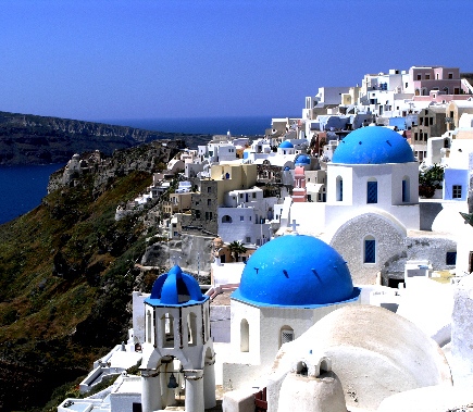
2. Oia (Ia) Village
Oia,
at the northern tip of the caldera, is Santorini’s most photographed
village and a postcard of Cycladic beauty. Perched on steep cliffs,
it features narrow cobblestone paths, whitewashed cave houses carved
into the rock, bougainvillea-draped terraces, and iconic blue-domed
churches (like those at Panagia Platsani).
Highlights include:
Oia Castle (ruins of Agios Nikolaos): A 15th-century
Venetian/Byzantine fortress offering the island’s premier sunset
views over the caldera.
Ammoudi Bay: A tiny harbor at the base of
300+ cliffside steps, with seafood tavernas, a small beach, and boat
access.
Windmills and art galleries lining the streets.
Oia is romantic and upscale but can be crowded—visit at sunrise or
early morning for quieter magic. It’s a cultural heritage site,
embodying Santorini’s blend of history and aesthetics.
3.
Fira (Thira) – The Capital
Fira sits dramatically atop the
caldera cliffs as the island’s bustling heart and main hub. Founded
in the 19th century, it offers lively squares, boutique shops,
open-air cafés, and jaw-dropping views of the volcano and cruise
ships below.
Key spots:
Cliffside terraces and the cable
car down to the old port (a thrilling ride).
Three Bells of Fira
and Orthodox/Catholic cathedrals with classic blue domes.
Museum
of Prehistoric Thera: Houses Akrotiri artifacts like frescoes and
pottery.
Fira feels more cosmopolitan and energetic than Oia,
with great dining and shopping. It’s the perfect base for exploring
the caldera rim.
4. Akrotiri Archaeological Site
Often
called the “Minoan Pompeii” or “Greek Pompeii,” Akrotiri is
Santorini’s premier historical landmark. This Bronze Age settlement
(dating back to ~5000 BCE, flourishing ~17th century BCE) was buried
under volcanic ash during the massive eruption but remarkably
preserved—no bodies were found, suggesting the inhabitants evacuated
beforehand.
You’ll walk through paved streets, multi-story houses
with advanced drainage/sewage systems, storage rooms, and frescoes
(originals now in Fira’s museum; replicas on site). Highlights
include the “Blue Monkeys” and “Spring Fresco.” A modern roof
protects the ruins. It offers a fascinating glimpse into
Minoan/Cycladic daily life, trade, and art—far more advanced than
many realize. Located near the south of the island; combine with a
beach visit.
5. The Active Volcano (Nea Kameni) and Hot
Springs
The caldera’s heart is still volcanically active. Boat
tours from Fira or Athinios port take you to Nea Kameni (the newest
island, formed in the 18th–20th centuries), where you can hike the
crater rim amid sulfur vents and rugged lava fields. Nearby Palea
Kameni offers natural hot springs for swimming (the water turns
reddish from minerals).
These trips highlight Santorini’s ongoing
geology and are a highlight for adventure seekers. The volcano last
erupted in 1950 but remains monitored.
6. Red Beach (Kokkini)
and Other Volcanic Beaches
Red Beach, near Akrotiri, is one of
Santorini’s most dramatic: rust-red volcanic cliffs tower over a
small stretch of reddish-black sand and pebbles, with turquoise
water. Accessible by short path or boat, it’s stunning but can be
crowded and has limited facilities—bring shade and water.
Other
beaches showcase the island’s volcanic diversity:
Black sand
beaches (Perissa, Perivolos, Kamari): Long stretches with dark sand
from lava, backed by tavernas and often organized with
umbrellas/loungers.
White Beach or Vlychada: Sculpted white
pumice cliffs, more secluded.
7. Ancient Thera
Perched
high on Mesa Vouno mountain (between Perissa and Kamari), this
ancient city dates to the 9th century BCE (Dorian colonists) and
thrived through Hellenistic and Roman times. Ruins include the agora
(marketplace), theater, temples (e.g., to Apollo), gymnasium, baths,
and a terrace for festivals. The elevated position offers sweeping
ocean views.
It’s a rewarding hike or drive-up site for history
buffs seeking a more classical (vs. prehistoric) perspective.
Other Notable Landmarks
Pyrgos: A traditional medieval
village with a hilltop Venetian castle (Kasteli) offering 360° views
and quieter charm than Oia/Fira.
Imerovigli and Skaros Rock:
“Balcony of the Aegean” with a short hike to fortress ruins and
unbeatable caldera panoramas.
Profitis Ilias Monastery: Highest
point on the island, with monastery buildings and panoramic views.
Wineries (e.g., Santo Wines, Koutsogiannopoulos Wine Museum):
Volcanic soil produces excellent Assyrtiko wines; many offer
tastings with caldera views.
Akrotiri Lighthouse: Remote and
scenic, great for sunset photos.
1. By Air (Fastest and Most Convenient for Most Travelers)
The
primary gateway is Santorini International Airport (JTR), also called
Thira Airport, located near Kamari on the east side of the island (about
5-7 km from Fira).
From Athens (ATH): The most common route.
Direct flights take 45-50 minutes. Aegean Airlines and Sky Express
operate multiple daily flights year-round. This is ideal after an
international arrival in Athens.
Direct International Flights:
Seasonal (mainly May-October) from many European cities, including
London, Paris, Rome, Milan, Amsterdam, Frankfurt, Manchester, and
others. Airlines include British Airways, easyJet, Ryanair, Transavia,
Lufthansa, and more.
From North America/Other Long-Haul: No direct
flights. Fly to Athens (or sometimes a European hub like Frankfurt,
Zurich, or London for a connection to JTR). Book as one ticket if
possible for better protection on connections.
Airport Tips:
JTR is small and can get very busy in peak season.
Facilities include
ATMs, car rentals, and basic food options.
Getting from JTR to
Your Hotel (e.g., Fira, Oia, or elsewhere):
Bus: Cheap (~€2 to Fira,
10-15 min). Buses run from outside arrivals; pay cash. Change in Fira
for Oia (~another €2).
Taxi: €30-50 to Fira (5-10 min), €40-70+ to
Oia (20-30 min). Limited supply—queues form quickly.
Private
Transfer/Shuttle: Recommended. Pre-book via your hotel, Welcome Pickups,
or similar (~€20-50+ depending on group/size). Reliable and stress-free.
Car Rental: Available at the airport, but driving on Santorini's narrow,
cliffside roads isn't for everyone.
2. By Ferry (Scenic and
Relaxing Option)
Ferries arrive at Athinios Port (main commercial
port, ~7-8 km from Fira). This is a great way to experience the Aegean
and arrive with a classic caldera view on some routes.
From
Athens (Piraeus Port): Daily year-round, multiple sailings in summer (up
to 9+).
High-speed (e.g., SeaJets): 4.5-6 hours, more expensive
(~€50-90+).
Conventional (e.g., Blue Star Ferries): 7-8+ hours,
cheaper and more stable/comfortable (~€40-60+).
From Other
Islands: Frequent connections from Mykonos, Crete, Naxos, Paros, etc.
(via companies like SeaJets, Blue Star).
Rafina Port (closer to
Athens Airport): Seasonal option, useful if arriving by air.
Booking: Use Ferryhopper.com or similar for schedules/prices. Book in
advance for summer.
From Athinios Port to Hotels:
Bus: Meets most
ferries, ~€2-3 to Fira (20-30 min). Change in Fira for Oia. Pay cash;
can be crowded.
Taxi/Private Transfer: €30-60+ to main towns.
Pre-book for reliability.
Note: Schedules align with ferry arrivals,
but always check KTEL Santorini buses.
Pro Tip: For the most
scenic arrival, take a slower ferry into the caldera (visible on some
approaches).
3. By Cruise Ship
Many Mediterranean cruises stop
in Santorini (tender port). Ships anchor in the caldera; passengers
tender to the Old Port below Fira (Skala).
From there: Cable car
up to Fira (€6-10+), donkey/mule (controversial), or 600+ steps. Then
bus/taxi to Oia or elsewhere.
Water taxis or organized transfers
sometimes go directly toward Oia.
Day visits are rushed due to
typical 8 AM–6 PM schedules; multiple ships amplify crowds.
Practical Tips for a Smooth Trip
Best Time to Visit: Shoulder
seasons—May/June or September/early October—offer great weather (warm
but not extreme), swimmable seas, and fewer crowds than July-August
peak. Avoid peak summer if you dislike congestion. April/October are
milder but riskier for ferries/flights due to weather.
Booking Ahead:
Essential for summer flights/ferries/hotels. Book transfers too.
Luggage: Ferries are easier with lots of bags; flights have stricter
limits.
Seasickness: High-speed ferries can be bumpy in wind (common
in Cyclades). Fly if prone.
Customs/Connections in Athens: For
international arrivals, clear immigration, then connect domestically
(same or separate ticket). Allow 2-3+ hours buffer.
On the Island:
Rent a car/ATV/quad for flexibility, or use buses/taxis/tours. Roads are
winding—drive carefully.
Costs: Expect higher prices in peak season.
Ferries ~€40+, short flight ~€50-150+ one-way.
Best Time to Visit
The island’s main season runs from late March
to early November. Shoulder seasons (late April–early June and
mid-September–late October) strike the best balance: pleasant weather
(18–27°C/65–80°F), warm sea for swimming, fewer crowds, and lower prices
than peak summer.
Peak summer (July–August): Hottest (up to
30°C+), busiest with cruise crowds, and most expensive. Great for beach
time but packed.
Spring (April–May) or Autumn (Sept–Oct): Ideal for
hiking and exploring without extreme heat.
Winter (Nov–March): Quiet
and cheaper, but many hotels/restaurants close, weather is cooler (often
10–15°C), and seas can be rough.
Pro tip: Visit in early October
for near-perfect conditions with thinner crowds.
How Many Days?
3–4 days (4–5 nights): Enough for highlights (Oia sunset, caldera hike,
boat tour, one beach day).
5–7 days: Better for a relaxed pace,
wineries, inland villages, and more beach time
Where to Stay
Choose based on vibe and mobility:
Oia: Iconic sunsets, luxury cave
hotels, blue domes. Most romantic/crowded/expensive. Good for couples.
Walk to Ammoudi Bay for seafood.
Fira: Capital, central hub, widest
budget range, nightlife, shopping, easy bus access. Lively but crowded.
Imerovigli or Firostefani: Quieter caldera views between Fira and Oia.
Great balance.
Finikia (near Oia): Peaceful alternative to Oia
crowds, charming and more affordable.
South/east (Akrotiri, Perissa,
Kamari, Megalochori, Pyrgos): Closer to beaches, cheaper, traditional
feel. Better with a car.
Booking tip: Caldera-view rooms with
plunge pools are premium. Book early, especially for sunset spots. Many
hotels offer transfers.
Getting Around
Buses (KTEL): Cheapest
(€1.80–2.80), reliable but infrequent off-peak. Main station in Fira.
Cash only.
Car/ATV/Quad rental: Most flexible for exploring inland
villages and beaches (~€15–50/day). Roads are narrow, steep, and
winding—drive cautiously. International license often needed.
Taxis:
Available but scarce/pricey during peaks; pre-book. Apps like Uber/Bolt
work but costly.
Walking: Caldera path (Fira–Oia) is scenic and
doable (3–5 hours one way).
Boat: For tours or short hops to
Thirassia.
Safety note: Roads see many accidents—especially with
inexperienced ATV riders. Wear helmets.
Top Things to Do
Watch
sunset in Oia (or Imerovigli/Fira for fewer crowds). Arrive early.
Hike Fira to Oia (or sections): ~10km along the caldera rim. Best early
morning. Stunning views, moderate difficulty.
Caldera boat/catamaran
tour: Swim in hot springs, visit the volcano (Nea Kameni), stop at
beaches. Sunset versions popular; include BBQ/drinks. Book small-group
for better experience.
Beaches: Black sand (Perissa/Kamari), Red
Beach (dramatic but rocky/falling stones risk), White Beach (boat
access). Beach clubs or free spots.
Wineries: Volcanic soil produces
excellent Assyrtiko whites. Visit Santo Wines, Venetsanos, Sigalas for
tastings with views. Tours available.
Akrotiri Archaeological Site:
Well-preserved Minoan ruins (ancient "Pompeii").
Inland villages:
Pyrgos (views, traditional), Megalochori, Emporio for quieter charm.
Other activities: Sea kayaking, scuba diving in caldera, horseback
riding, Skaros Rock hike.
Practical Tips
Crowds: Cruise ships
(capped at ~8,000/day) hit Fira/Oia mornings. Visit early or late.
Shoulder season helps hugely.
Money: Euros. Cards widely accepted,
but cash for buses/small spots. ATMs charge fees—use bank ones.
Food:
Fresh seafood, Greek salads, fava, tomatokeftedes, grilled octopus.
Caldera-view dinners romantic but pricier (€25–35/person with drinks).
Souvlaki/gyros for budget (~€6–12). Tipping: 5–10% optional but
appreciated.
Water: Don’t drink tap—use bottled (hotels often
provide).
Dress/essentials: Comfortable walking shoes (stairs
everywhere), hat/sunscreen (intense sun), light layers for evenings,
reusable water bottle. Modest clothing for churches.
Health/Safety:
Safe island, low crime. Watch cliffs after dark/drinks. Pharmacies and
hospital in Fira. Emergency: 112.
Sustainability: Limited water;
respect no-new-build rules and environment.
Photography: Golden hour
best. Drones restricted in some areas.
Geological Formation and Prehistory
Santorini is part of a
volcanic island arc formed by the subduction of the African tectonic
plate beneath the Eurasian plate. Volcanism here began around 3–4
million years ago, with activity on Thera itself starting about 2
million years ago. The island rests on a non-volcanic basement of
metamorphosed limestone and schist from the Miocene era. Over time,
repeated shield volcano building and caldera collapses created the
modern landscape. At least 12 major explosive eruptions have occurred,
with four forming large calderas. The oldest southern caldera dates to
about 180,000 years ago, followed by the Skaros caldera (~70,000 years
ago) and Cape Riva caldera (~21,000 years ago).
Before the most
famous eruption, the island was likely more rounded (sometimes called
Strongili, meaning “round” in ancient Greek). Human presence dates to
the Late Neolithic period (4th millennium BC or earlier), but
significant settlement emerged in the Bronze Age.
The Bronze Age:
Akrotiri and the Catastrophic Minoan Eruption (~1600 BCE)
The most
pivotal event in Santorini’s history was the Minoan (or Thera) eruption
around 1645–1600 BCE (radiocarbon and tree-ring dating; some traditional
chronologies place it near 1500 BCE). This VEI 7 (or possibly higher)
Plinian eruption ranks among the largest in the last 10,000 years,
ejecting 60+ km³ of magma and producing massive tephra deposits up to 60
meters thick in places. It unfolded in phases: initial pumice fallout,
phreatomagmatic surges (when seawater met magma), pyroclastic flows, and
caldera collapse, which generated destructive tsunamis that likely
impacted Crete and other Aegean coasts.
The eruption buried the
thriving Minoan settlement of Akrotiri on the island’s southern coast,
often called the “Pompeii of the Aegean.” Excavations (led by Spyridon
Marinatos from 1967) reveal a sophisticated Bronze Age port town with
multi-story buildings, paved streets, advanced drainage systems
(including hot and cold water pipes), workshops, and storage pithoi. No
human remains have been found, suggesting residents evacuated after
precursor earthquakes. The ash preserved exquisite frescoes depicting
daily life, nature, and maritime scenes—saffron gatherers, antelopes,
dolphin-filled boats, and ritual offerings—highlighting a wealthy,
cosmopolitan society with trade links to Crete, Egypt, Cyprus, Syria,
and the Greek mainland.
The disaster likely contributed to the
decline of Minoan civilization on Crete through tsunamis, ashfall, and
economic disruption, though direct causation is debated. Some scholars
link it (speculatively) to the Atlantis legend in Plato’s works, though
archaeological evidence does not strongly support this.
Post-eruption, the island was largely abandoned for centuries as the
caldera filled with seawater, creating the iconic landscape we see
today. Smaller post-Minoan eruptions later formed the central Kameni
islands (Palaea and Nea Kameni), with historical activity continuing
into the 20th century (last in 1950).
Ancient Greek Period (9th
Century BCE Onward)
Phoenicians reportedly settled briefly (calling
it Calliste, “the most beautiful”), but Dorian Greeks from Sparta, led
by Theras, colonized the island around the 9th century BCE. They founded
Ancient Thera on the mesa-like ridge of Mesa Vouno (396 m elevation), a
strategic defensive and trade hub overlooking the sea. The city included
an agora, theater, temples (notably to Apollo), stoas, and houses;
inscriptions reveal Dorian customs, including ritual pederasty.
Thera
sided with Sparta during the Peloponnesian War (5th century BCE) and did
not join the Delian League. It later became a Ptolemaic naval base after
Alexander the Great. A famous myth in Apollonius Rhodius’ Argonautica
ties its origins to the Argonauts. Around the 7th century BCE, Therans
colonized Cyrene in Libya during a drought.
Byzantine, Medieval,
and Venetian Eras (4th–16th Centuries)
Under Roman and then Byzantine
rule, Christianity spread, with early churches built. A major volcanic
event in 727 CE (during Emperor Leo III’s reign) was interpreted as
divine support for Iconoclasm. Pirate raids plagued the island from the
7th–14th centuries, prompting fortified settlements.
After the Fourth
Crusade (1204), Santorini became part of the Venetian Duchy of Naxos.
The name “Santorini” derives from “Santa Irini” (Saint Irene), first
recorded in the 12th century. Venetian families like the Barozzi
controlled it, building castles (casteli) at sites like Skaros, Pyrgos,
Emporio, and Oia for defense against pirates and Turkish raids. Catholic
influence grew alongside Orthodox Christianity, with goulas
(watchtowers) and clustered hilltop villages for protection.
Ottoman Rule (1579–1821)
Ottoman admiral Piyale Pasha captured
Santorini in 1579. It enjoyed semi-autonomy under figures like Joseph
Nasi (a Jewish advisor to the sultan). No significant Muslim population
settled, and Orthodox faith thrived. The island developed a strong
merchant fleet and exported volcanic soil-enriched wines (notably
Vinsanto) to Russia and beyond. It faced occasional Venetian raids and
Russian occupation (1768–1774) during Russo-Turkish wars.
In the
Greek War of Independence (1821), Santorini actively supported the
revolution with ships, sailors, wine supplies, and funds, expelling
Ottoman officials and joining the new Greek state by the 1830s.
Modern History: From Agriculture to Tourism (19th–21st Centuries)
In
the 19th–early 20th centuries, the economy relied on wine, tomatoes
(canning factories), shipping, and pumice mining. The island prospered
but faced challenges.
World War II brought Italian (1941) then German
(1943) occupation; a British raid in 1944 led to reprisals. Post-war
decline followed, exacerbated by the devastating 1956 Amorgos earthquake
(magnitude ~7.5–7.8), which destroyed much of the island, killed dozens
locally, triggered tsunamis, and caused mass emigration.
Tourism
began modestly in the 1950s with yacht visitors but exploded from the
1970s onward. Infrastructure improvements, the closure of pumice
quarries (1986) for preservation, and the island’s unique geology and
archaeology drove growth. Today, Santorini welcomes ~2 million visitors
annually, with whitewashed villages (Fira, Oia), luxury resorts, and
wine tourism dominating the economy. It ranks among the world’s top
islands while emphasizing sustainable development.
The legend of Atlantis originates entirely from the ancient Greek
philosopher Plato (c. 427–347 BCE) in his dialogues Timaeus and Critias
(written around 360 BCE). These works present it as a story told by
Egyptian priests to the Athenian lawgiver Solon (c. 600 BCE), who passed
it to Plato’s ancestors. Atlantis is depicted as a vast, advanced island
civilization in the Atlantic Ocean, beyond the “Pillars of Heracles”
(Strait of Gibraltar). It featured concentric rings of alternating land
and water (two rings of land and three of sea), a central plain,
sophisticated engineering (canals, harbors, bridges, irrigation), a
powerful navy, and a prosperous society that eventually turned
hubristic. It waged war against prehistoric Athens but was defeated.
Then, “in a single day and night of misfortune,” violent earthquakes and
floods caused it to sink beneath the sea, leaving an impassable mud
shoal that blocked navigation.
Plato’s account is philosophical and
allegorical—likely contrasting an ideal Athens with a corrupt imperial
power—but many have sought a historical kernel behind it. One of the
most persistent and compelling hypotheses links it to Santorini (ancient
Thera), a volcanic island in the southern Aegean Sea (part of the
Cyclades, Greece), and the catastrophic Minoan eruption that reshaped it
around 1620–1600 BCE.
Santorini’s Geology and the Minoan Eruption
Santorini is not a typical island but the remnant of a massive
stratovolcano. Before the Bronze Age eruption (known as the Minoan or
Thera eruption), it was a more complete, roughly circular landmass
formed by earlier volcanic activity, with a central shield volcano or
cone. The cataclysmic event—one of the largest volcanic explosions in
the last 10,000 years (Volcanic Explosivity Index 6–7, comparable to or
larger than Krakatoa in 1883)—ejected enormous volumes of ash, pumice,
and rock. The central part of the island collapsed into the emptied
magma chamber, forming the iconic caldera (a water-filled crater up to
400m deep) we see today. The modern islands (Santorini proper, Therasia,
Aspronisi, and smaller ones like Nea Kameni) are fragments of the
pre-eruption ring.
This collapse effectively made a large section of
the island “sink” into the sea overnight, accompanied by earthquakes,
massive tsunamis (estimated 20–65+ feet high, devastating northern Crete
~70–120 km south), widespread ash fallout, and temporary blockage of sea
routes by pumice rafts. Radiocarbon, dendrochronology (tree-ring
dating), and ice-core data pinpoint the eruption around 1613–1620 BCE,
with some older estimates around 1500 BCE.
Archaeologically, the
eruption buried the Minoan settlement of Akrotiri (on the southern part
of the island) under meters of ash and pumice—preserving it remarkably,
much like Pompeii. Excavations (led notably by Spyridon Marinatos from
the 1960s onward) revealed a sophisticated Late Bronze Age town:
multi-story houses with advanced drainage and plumbing, elaborate
frescoes (including the famous “Fleet Fresco” depicting a flotilla of
ships, suggesting naval prowess), storage facilities, and no human
remains (implying possible prior evacuation due to precursor
earthquakes). The Minoans, centered on Crete but with outposts and trade
networks across the Aegean and beyond, were a highly advanced maritime
culture known for palaces (e.g., Knossos), vibrant art, bull-leaping
rituals, and extensive commerce.
Key Parallels Supporting the
Santorini-Atlantis Link
Proponents argue that Plato’s tale preserves
a distorted cultural memory of this real Bronze Age catastrophe,
transmitted via Egyptian-Minoan trade contacts (Minoans appear in
Egyptian records as “Keftiu,” traders bringing luxury goods). The main
points of convergence include:
Geographical and Topographical
Matches: Plato describes concentric rings of land and water around a
central island/mountain. Pre-eruption Thera’s circular shape, with its
central volcanic edifice and surrounding topography, closely resembles
this layout. The post-eruption caldera—with its lagoon and encircling
cliffs—evokes the “sinking” and ringed structure even more dramatically.
Geological studies confirm the pre-Minoan island had a ring-like form
with a central shield. Some reconstructions show it as strikingly
similar to artistic depictions of Atlantis.
Catastrophic Destruction:
The “single day and night” of earthquakes and floods mirrors the caldera
collapse, seismic activity, and tsunamis. Post-eruption pumice made
parts of the Aegean temporarily “impassable,” akin to Plato’s mud
shoals. The eruption’s regional impact (ash darkening skies, tsunamis
hitting Crete) could explain the sudden “vanishing.”
Advanced
Civilization: Akrotiri and Minoan Crete featured urban planning,
engineering, wealth, and seafaring power that echo Atlantis’s
description. The Minoan decline (palaces damaged or abandoned around
1450–1400 BCE, possibly exacerbated by the eruption’s economic ripple
effects like disrupted trade) parallels Atlantis’s fall from divine
favor and military overreach. Some link the bull cult and other motifs
culturally.
Timeline and Transmission Adjustments: Plato’s date
(9,000 years before Solon, ~9600 BCE) is far too early. A common
proposal (popularized by geologist Angelos Galanopoulos in the 1960s) is
a scribal or interpretive error: Egyptian priests may have used lunar
years or a factor-of-10 mistake (900 years instead of 9,000), aligning
it with ~1600 BCE. The story’s Egyptian source fits Minoan-Egyptian
trade.
A 2026 refinement by Elias Stergakos (Atlantis: An Aegean
Island) addresses geography: Plato contrasts the Mediterranean (“sea
within the Straits of Heracles,” like a harbor) with the “true sea” (a
vast, dangerous body surrounded by a “boundless continent”).
Traditionally problematic for an Aegean site, Stergakos identifies the
“true sea” as the Black Sea (ancient Póntos Áxeinos, later just Pontos),
with the Aegean/Santorini as the island route leading to Anatolia and
other lands encircling it. This makes the Mediterranean fit Plato’s
“harbor” description perfectly.
Criticisms and Why It’s Not
Universally Accepted
Despite the appeal, the theory faces significant
challenges and is not mainstream scholarly consensus:
Scale and
Location Mismatch: Plato’s Atlantis is enormous (“larger than Libya and
Asia combined”) and explicitly in the Atlantic Ocean, not the tiny
Aegean. Santorini’s pre-eruption size was modest (~10–15 miles across).
Defenders argue Plato exaggerated for philosophical effect or that
“Libya and Asia” referred to known regions in a relative sense (or a
translation error for “between”).
Chronological Issues: The eruption
(~1620 BCE) predates the final major Minoan palace destructions (~1450
BCE) by over a century. Minoan society recovered and continued (with
possible Mycenaean influence), not collapsing immediately. Egyptian
records of Keftiu show no sudden catastrophe.
Lack of Direct
Evidence: No inscriptions call Akrotiri or Thera “Atlantis.” Plato
likely invented or heavily stylized the tale as moral allegory (ideal
Athens vs. imperial hubris). No Greek historians before Plato mention a
Thera catastrophe in this context.
Alternative Explanations: Atlantis
could draw from multiple sources (e.g., other floods, Troy, or pure
fiction). The Minoan decline involved multiple factors (earthquakes,
invasions, internal strife).
Scholars like those critiquing the
“Minoan hypothesis” conclude the links are intriguing but insufficient
for proof; the eruption was devastating locally but not the sole cause
of regional collapse, and the geographical/scale discrepancies are too
great without heavy reinterpretation.
Overall Assessment
The
Santorini-Atlantis connection remains one of the most scientifically
grounded “real event” theories for the legend. The Thera eruption’s
scale, the preserved sophistication of Akrotiri, and the visual drama of
the caldera provide a plausible kernel of folk memory that could have
reached Plato via Egyptian intermediaries centuries later. It’s not
literal history—Plato almost certainly adapted and mythologized it—but
it offers a compelling explanation for how a real Bronze Age disaster
might have inspired one of the West’s most enduring myths. Ongoing
research (geology, archaeology, and reinterpretations like Stergakos’s)
keeps the debate alive, but Atlantis is probably best understood as
philosophy wrapped in a cautionary tale rather than a literal atlas
entry. The mystery endures, much like the beautiful, brooding caldera of
Santorini itself.
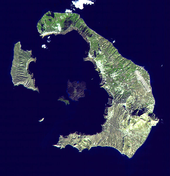
Archipelago Composition and Size
Santorini is not a single island
but a semicircular/horseshoe-shaped archipelago of volcanic islands
surrounding a central water-filled caldera. The municipality of
Santorini includes:
Thira (Santorini proper): the main and
largest island, covering approximately 73–76 km².
Therasia: the
second-largest inhabited island, about 9.3 km².
Smaller uninhabited
islets: Aspronisi (~0.1 km²), Nea Kameni (~3.4 km²), and Palea Kameni
(~0.5 km²), plus even tinier ones like Christiana and Anydros.
The total land area of the municipality is roughly 90–96 km², with a
combined coastline of nearly 69 km. The islands form a ring around the
caldera lagoon, giving the group its distinctive crescent shape when
viewed from above.
The Santorini Caldera: The Defining Feature
The caldera is Santorini’s most iconic geographic element—a large,
mostly submerged volcanic depression measuring about 12 km by 7 km. It
is filled with seawater to a maximum depth of around 385–400 meters,
creating a deep, lagoon-like harbor. Steep cliffs rise dramatically
along three sides of the main islands, often exceeding 300 meters in
height (with a total vertical drop from cliff top to seafloor exceeding
700 meters in places). These cliffs display beautifully layered strata
of lava, pumice, ash, and ignimbrite from successive eruptions, in
colors ranging from white and beige to red, brown, and black.
The
caldera is often described as the world’s only inhabited sunken caldera.
Towns like Fira, Oia, and Imerovigli perch precariously along its rim,
offering breathtaking views over the central volcanic islets (Nea and
Palea Kameni) and the deep blue waters. The outer perimeter of the
islands slopes more gently toward the open Aegean Sea, with smoother
coastlines.
Geological History and Volcanism
Santorini lies at
the heart of the South Aegean Volcanic Arc (part of the Hellenic Arc), a
500 km-long zone of intense volcanism caused by the subduction of the
African tectonic plate beneath the Eurasian plate. Volcanism in the
region began 3–4 million years ago, with activity on Santorini itself
starting around 2 million years ago through dacitic lava flows.
The
island complex has undergone repeated cycles of shield-volcano building
followed by catastrophic caldera collapses. At least four major
overlapping calderas have formed over the past ~180,000 years:
The oldest southern caldera (~180,000 years ago).
Subsequent events
around 76,000 and 21,000 years ago.
The most recent and famous Minoan
eruption (~3,600 years ago, c. 1600 BCE), one of the largest explosive
eruptions of the Holocene (VEI 7). This event emptied a massive magma
chamber, causing the caldera to collapse dramatically and expelling an
estimated 60+ km³ of magma and 100 km³ of tephra. It buried the ancient
settlement of Akrotiri under thick ash and pumice layers and reshaped
the islands into their current form.
Post-Minoan activity has
concentrated on the central Kameni islets, which have grown through
submarine and subaerial eruptions. The most recent eruption on Nea
Kameni occurred in 1950; the volcano remains active, with fumaroles, hot
springs, and ongoing seismic monitoring. The landscape is dominated by
pyroclastic deposits, lava flows, and volcanic domes.
Topography
and Terrain
Santorini’s terrain is rugged and varied due to its
volcanic origins:
Caldera (inner) side: sheer, multicolored cliffs
dropping vertically into the lagoon.
Outer slopes: gentler gradients
leading to the sea, with terraced hills ideal for agriculture.
Highest point: Mount Profitis Ilias (Profitis Elias) in the southeast of
Thira, reaching 566–567 m above sea level, topped by a monastery. Other
notable elevations include Mesa Vouno (~396 m).
Pre-volcanic basement
rocks (metamorphosed limestone and schist from the Oligocene–Miocene)
are exposed in places like Mikros Profitis Ilias and coastal ridges.
The coasts feature some of the most distinctive beaches in Greece:
Black sand/pebble beaches (e.g., Perissa, Kamari) — dark volcanic
material that absorbs heat, warming the shallow waters.
Red Beach
near Akrotiri — striking red cliffs and sand rich in iron oxides.
White, grey, or mixed volcanic-sand beaches elsewhere.
These
color variations reflect different geological layers and eruption
products.
Climate
Santorini has a hot semi-arid climate
(Köppen BSh) with strong Mediterranean (Csa) influences. Summers are
hot, dry, and sunny, moderated by the strong northerly Meltemi winds.
Winters are mild and relatively wetter. Annual precipitation averages
only about 270 mm (mostly in winter months), and the mean annual
temperature is around 19 °C. The low rainfall and porous volcanic soils
create a dry landscape, though sea fog and dew provide some moisture for
vegetation.
Hydrography, Soils, and Vegetation
Due to the arid
climate and highly permeable volcanic soils, Santorini has no permanent
rivers or lakes. Drainage is episodic via small torrents after rare
heavy rains. Freshwater is scarce; the island historically relied on
rainwater cisterns and now uses desalination.
The volcanic soils
(rich in minerals from ash and pumice) are exceptionally fertile despite
the dryness. This supports intensive agriculture, most famously
low-growing basket-trained vineyards (Assyrtiko grapes) that produce
world-renowned wines, along with tomatoes and other crops. Natural
vegetation is sparse and typically Mediterranean—shrubs, wild herbs, and
occasional olives—adapted to the windy, dry, and rocky conditions. The
unique geology also creates micro-habitats around fumaroles and hot
springs on the Kameni islets.