Location: Cēsis Map
Area: 917 km² (92000 ha)
Gauja National Park is a natural reserve in Cēsis
region in Latvia. This nature reserve derives its name from a valley
of a Gauja river. Covering an area of 917 km² it is largest and
oldest national park in the country found in September of 1973. The
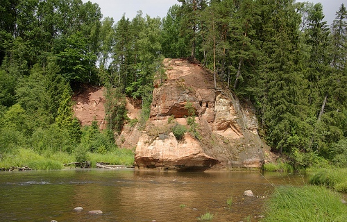
banks of the river are largely made up from sandstone cliffs that
were formed during Devonian period. In some areas they reach a
height of 90 meters. Despite temptation to jump from these
geological formations it is not advisable to carry out this practice
due to low water level in some places. Nicknamed a "Livonian
Switzerland" it attracts thousands of tourists every year. Some of
the caves in the sandstone cliffs preserve graffiti of hikers who
visited these places in the 19th century. Most of the land area of
the Gauja National Park are covered by pine and spruce forests as
well as 900 other plant species. Additionally there are 48 species
of mammals and 149 species of birds. Reserve has several lakes
within its borders, but its largest lake is a Lake Ungurs.
One of the most notable sights in the ancient valleys of Gauja
National Park is a medieval Āraišu Lake Castle as well as Soviet
secret underground bunker of Ligatne that was constructed to protect
population in case of a nuclear war between Soviet Union and United
States.
Geological Origins and Formation
The history of Gauja National
Park begins deep in geological time, with the formation of its defining
feature: the ancient valley of the Gauja River. The reddish, yellow, and
grayish sandstones that characterize the park's dramatic outcrops,
cliffs, and caves date back to the Devonian period, approximately
350-370 million years ago, when sediments were deposited in ancient
seas. The valley itself began taking shape around one million years ago
during the Quaternary glaciation period, as ice sheets sculpted the
landscape. Its current ravine-ridden terrain and meandering river course
were finalized about 12,000 years ago, at the end of the last Ice Age,
when glacial sediments and melting waters carved out the deep gorges and
deposited loose sand and gravel along the riverbed. This process created
a varied terrain with depths reaching up to 85 meters in areas like
Sigulda, featuring over 500 sandstone outcrops, such as the iconic
Sietiņiezis Rock and Ērgļu Cliffs, which are geomorphological monuments
protected for their scientific and aesthetic value. The park's area,
spanning 91,745 to 91,786 hectares across the Vidzeme region from
northeast of Sigulda to southwest of Cēsis, preserves this ancient
valley as its core, encompassing forests (about 47% of the area),
springs, and a high biodiversity with nearly 900 plant species, 149 bird
species, and 48 mammal species.
Prehistoric and Ancient Human
Settlement
Human interaction with the Gauja valley dates back to
prehistoric times, though evidence is sparse and intertwined with the
natural landscape. The river served as a vital trade route and natural
border between the territories of the Livonians (a Finnic people) and
Latgalians (a Baltic tribe) prior to the 13th century. Archaeological
sites, including hill forts (such as those near Cēsis), indicate early
settlements where communities lived harmoniously along the waterways.
These early inhabitants likely exploited the river for fishing,
transportation, and resources, with the valley's network of rivers and
land paths (known as the Via Magna of Livonia) facilitating regional
connections. Legends and folklore, often tied to natural features like
caves and cliffs, suggest a spiritual significance, with stories of
ancient rituals or mythical beings persisting in local oral traditions.
Medieval Period: Crusades, Castles, and Conflict
The medieval era
marked a transformative phase for the Gauja valley, as it became a
strategic frontier during the Livonian Crusades in the 13th century. The
area's extensive waterways and roads made it a key battleground and
territorial divider. In 1207, the Order of the Sword Brothers (later
absorbed into the Teutonic Order) and the Bishopric of Riga vied for
control, leading to the construction of fortified castles along the
riverbanks. Notable examples include:
Sigulda Castle (built in
1207 by the Order of the Sword Brothers), serving as a defensive
outpost.
Turaida Castle (erected in 1214 by the Bishop of Riga), a
red-brick fortress overlooking the valley, now a museum reserve with
exhibits on medieval life and the legend of the "Turaida Rose."
Krimulda Castle (dating to the same period), positioned across the river
for strategic cannon range.
These castles, often described as
standing "at a shooting distance of a cannon from each other,"
symbolized the division of power, with each bank of the Gauja controlled
by rival factions. Cēsis, founded around 1206 (approximately 800 years
ago), emerged as a medieval town with preserved street layouts, its
castle ruins offering insights into Hanseatic League influences and
daily life through interactive excursions involving crafts and games.
Other sites, like Gutman's Cave—the largest grotto in the Baltics—bear
inscriptions from the 17th century onward but are linked to medieval
legends, such as tales of forbidden love. The valley's over 500 cultural
monuments, including churches (e.g., St. Simon's Church in Valmiera),
manors, and mills, reflect this era's architectural and artistic legacy,
many entwined with myths.
Early Modern Period and the Rise of
Tourism in the 19th Century
Following the Crusades, the Gauja region
fell under various rulers, including the Polish-Lithuanian Commonwealth,
Sweden, and eventually the Russian Empire by the 18th century. Manors
like Valmiermuiža and Krimulda Manor developed as agricultural and
administrative centers, preserving historical structures amid shifting
political landscapes. The 19th century heralded the beginnings of
organized tourism, particularly in Sigulda, where the dramatic valley
views attracted Romantic-era travelers. Hiking with walking sticks
became popular, establishing the area as "Little Switzerland" due to its
alpine-like scenery. Gutman's Cave emerged as the oldest tourism site in
the Baltics, drawing visitors for its natural beauty and historical
carvings. This period laid the groundwork for the park's future role in
recreation, blending nature with cultural exploration.
20th
Century: Establishment Under Soviet Rule
The 20th century brought
significant changes, starting with Latvia's independence in 1918, though
the region remained largely rural and natural. World War II and the
subsequent Soviet occupation (1940-1991) influenced the area's
development. In 1973, Gauja National Park was formally established as
Latvia's first and largest national park, covering over 90,000 hectares,
under the Soviet regime. Inspired by Yosemite National Park's
centennial, the establishment aimed to protect cultural landscapes,
historical farmsteads, and traditions tied to national identity from
"unplanned transformations" like intensive agriculture. Unlike strict
Soviet "zapovedniki" (nature reserves), it emphasized recreation and
tourism, with zoning into an "inner park" (core protected area) and
"front park" (buffer zone allowing restricted agricultural use). This
reflected a discourse of human dominion over nature, transforming "wild"
areas into usable resources while preserving architecture for
ideological contrast with socialist progress. A notable Soviet-era relic
is the secret bunker in Līgatne, built in the 1980s and disguised as a
rehabilitation center, intended as a nuclear shelter for Latvian Soviet
elites. Early reserves like Nurmies Hollow and Roču Forest were
incorporated, focusing on geomorphological and biological protection.
Post-Soviet Era and Modern Developments
Following Latvia's
regained independence in 1991, the park's management evolved. In 2004,
it joined the European Union's Natura 2000 network (code: LV0200100),
shifting priorities toward biodiversity conservation, protected species,
and habitats, aligning with IUCN Category II standards. Governed by the
Ministry of Environmental Protection and Regional Development, with
administration in Sigulda under the Nature Conservation Agency's Vidzeme
unit, it adopted management plans (2004-2013, extended to 2018; updated
in 2023) emphasizing ecosystem restoration, such as prescribed burning
for forest habitats. This transition sparked conflicts, including
debates over intensive forestry, habitat projects, and restrictions
perceived as limiting local utilitarian values like small-scale logging.
Public perceptions vary, with moralistic values (ethical responsibility
toward nature) clashing against scientific approaches, as seen in media
coverage from 2004-2022 highlighting issues like bark beetle damage and
clearcuts.
Gauja National Park, located in the Vidzeme region of northeastern
Latvia, is the country's largest and oldest national park, established
in 1973 to protect a diverse array of natural and cultural features.
Spanning approximately 917.86 square kilometers (about 354 square miles
or 91,745 hectares), it stretches along the ancient valley of the Gauja
River, from northeast of Sigulda in the southwest to southwest of Cēsis
in the northeast, encompassing parts of several municipalities including
Sigulda, Cēsis, and Valmiera. This elongated park follows the river's
course for roughly 93 kilometers, forming a natural corridor that
highlights Latvia's glacial and post-glacial heritage. The park is
divided into five functional zones, balancing conservation with
recreation, research, and limited economic activities, ensuring that
core natural areas remain protected while allowing for sustainable
tourism.
The topography of Gauja National Park is remarkably varied,
characterized by a deep river valley system sculpted by ancient
geological processes. The Gauja River valley, the park's dominant
feature, reaches a maximum depth of 85 meters near Sigulda, where it
widens to about 1 kilometer, creating dramatic escarpments and
meandering bends. This ancient valley originated over 300 million years
ago during the Devonian period but acquired its current form
approximately 12,000 years ago through the action of glacial meltwaters
and sediments, which eroded and reshaped the landscape. The terrain
includes steep slopes, ravines, and undulating hills, with elevations
ranging from around 20 meters above sea level in the riverbed to over
100 meters on surrounding plateaus. Sandstone cliffs and outcrops, often
rising 10-20 meters high, punctuate the valley walls, interspersed with
dolomite formations that add to the rugged profile. Numerous springs
emerge from these cliffs, feeding into tributaries and contributing to
the park's hydrological network. The landscape is further diversified by
boulder fields, pebble rapids, and occasional flat meadows in the valley
floor, making it a prime example of Baltic glacial geomorphology.
Hydrographically, the Gauja River serves as the park's lifeline, being
Latvia's longest river at 452 kilometers total, with a significant
portion winding through the protected area. Within the park, the river's
width varies from 60 to 120 meters (200-390 feet), and its depth
fluctuates between 0.3 and 7 meters (1-23 feet), influenced by seasonal
flows and the loose sand-and-gravel riverbed that shifts with currents.
The river's gradient is relatively gentle at about 0.8 meters per
kilometer (2.6 feet per mile), resulting in a flow rate of 0.2-0.4
meters per second during low water and up to 2-3 meters per second in
spring floods. Tributaries such as the Amata and Brasla rivers join the
Gauja, carving secondary valleys and adding to the network of streams
and wetlands. Boulder rapids, including notable ones like Kazu,
Raiskuma, Rakšu, and Ķūķu, create dynamic water features, while natural
springs—numbering in the hundreds—provide clear, mineral-rich water
sources that support local ecosystems. The valley's width expands to
1-2.5 kilometers in places, fostering floodplains that periodically
inundate during high water, enriching the soil and promoting
biodiversity.
Geologically, the park is a showcase of Devonian-era
formations, with exposed sandstones dating back 350-370 million years,
displaying hues of red, yellow, and gray due to iron oxide and other
mineral content. These sedimentary rocks form prominent cliffs, such as
the Ergli Cliffs or Sietiniezis Rock, and numerous caves, including the
largest in the Baltics, Gutman's Cave, which measures about 19 meters
deep and 12 meters wide. The underlying bedrock consists of dolomites
and marls, overlaid by Quaternary glacial deposits like tills, sands,
and gravels, which have been eroded by the river to reveal striking
stratigraphic layers. This erosion has created unique landforms such as
alcoves, pillars, and natural arches, making the park a key site for
studying Baltic geology. Seismic activity is minimal, but the soft
substrates are prone to landslides along steep banks, adding a dynamic
element to the landscape.
Soils in the park are predominantly
podzolic and alluvial, derived from glacial moraines and river
sediments, supporting fertile valleys and forested uplands. The climate
is temperate continental, with average annual temperatures around 5-7°C,
ranging from -5°C in winter to 17°C in summer. Precipitation averages
700-800 mm yearly, with higher amounts in the hilly areas, contributing
to the lush vegetation. Snow cover persists for 80-100 days in winter,
influencing river ice formation and seasonal hydrology.
Vegetation
covers much of the park, with forests occupying nearly half the
area—primarily mixed coniferous-deciduous stands of pine, spruce, birch,
and oak. These woodlands transition into meadows and wetlands along the
river, hosting over 870 plant species, including rare orchids and ferns
adapted to the moist, shaded cliffs. The biodiversity extends to fauna,
with 48 mammal species (such as deer, foxes, and beavers) and 150 bird
species (including eagles and woodpeckers), thriving in the varied
habitats from riverine corridors to upland forests. This rich ecological
tapestry underscores the park's role as a biodiversity hotspot in the
Baltic region.
Gauja National Park, established in 1973 as Latvia's oldest and
largest national park, spans approximately 917 km² in the Vidzeme region
along the Gauja River valley. It is celebrated for its exceptional
biodiversity, driven by diverse ecosystems such as ancient river
valleys, Devonian sandstone cliffs, caves, springs, forests, wetlands,
and mesotrophic lakes. This protected area, part of the Natura 2000
network since 2004, safeguards numerous habitats and species, including
45 protected biotopes. The park supports nearly 900 vascular plant
species, over 5,000 fungal species (with many represented locally),
147-163 bird species, 48-52 mammal species, over 200 vertebrate species
overall, 3,780 insect species, and a variety of reptiles, amphibians,
and fish. Forests cover 47-57% of the territory, providing critical
habitats, while water bodies and swamps add to the ecological richness,
making it a haven for both common and rare species.
Flora
The
flora of Gauja National Park is characterized by its high diversity,
shaped by the park's varied topography, soil types (from sandy to
peaty), and moisture levels. Vascular plants number 876 species, with 93
protected at the European level, reflecting the park's role in
conserving rare and endangered flora. These plants thrive in habitats
ranging from dry upland forests to wet valley slopes and mires, with
many adapted to the nutrient-poor sandstone substrates and seasonal
flooding along the Gauja River.
Forests dominate, comprising species
like Scots pine (Pinus sylvestris) in dry, sandy areas; Norway spruce
(Picea abies) in mixed stands; silver birch (Betula pendula) and downy
birch (Betula pubescens) in transitional zones; pedunculate oak (Quercus
robur), small-leaved lime (Tilia cordata), and ash (Fraxinus excelsior)
in broad-leaved forests on fertile slopes; and alder (Alnus incana and
Alnus glutinosa) along riverbanks and wetlands. Aspen (Populus tremula)
and willow (Salix spp.) are common in disturbed or wet areas,
contributing to dynamic succession. Understories feature grasses (e.g.,
Poa, Festuca, Calamagrostis), horsetails (Equisetum spp.), heather
(Calluna vulgaris), and bilberry (Vaccinium myrtillus), forming
associations like Vaccinio vitis-idaeae-Pinetum in dry pines or
Querco-Tilietum on valley slopes. These forests not only provide habitat
but also support medicinal and edible plants, with locals traditionally
foraging for herbs, berries, and nuts.
Wetlands and mires, such as
Sudas Mire, host specialized flora like sphagnum mosses and water
lilies, while sandstone cliffs and caves foster unique microhabitats for
ferns, mosses, and lichens clinging to exposed rock. The park includes
23 protected moss species, highlighted by the rare Campylopus fragilis,
a brittle moss discovered in expeditions, which thrives in acidic,
disturbed soils. Lichens are equally diverse, with 166 types documented
and recent surveys adding 60 new records for the park, including
lichenized and allied fungi that indicate clean air and old-growth
forests.
Fungal diversity is remarkable, with 551 species of capped
mushrooms alone, part of Latvia's broader 4,000+ fungal species.
Habitats like deadwood, decayed trees, and manor parks foster edibles
and rarities such as the parasol mushroom (Macrolepiota procera,
Latvia's largest cap mushroom), chestnut bolete (Gyroporus castaneus),
lurid bolete (Boletus luridus), sheep polypore (Albatrellus ovinus),
coral mushroom (Ramaria aurea), chanterelles (Cantharellus spp.),
russulas (Russula spp.), king boletes (Boletus edulis), woolly milkcaps
(Lactarius torminosus), orange milkcaps (Lactarius deliciosus), and
gypsy mushrooms (Cortinarius caperatus). These thrive in areas like
Silciems and Lielstraupe forests, varying by season and moisture.
Fauna
Gauja National Park's fauna benefits from its mosaic of
habitats, supporting 58 protected animal and bird species at the
European level. The park's rivers, forests, and mires create niches for
predators, herbivores, and aquatic life, with many species exhibiting
secretive behaviors but observable through trails, observation towers,
or quiet exploration.
Mammals
Out of Latvia's roughly 60
mammal species, 48-52 reside here, representing high mammalian
diversity. Large herbivores include elk (Alces alces), red deer (Cervus
elaphus), roe deer (Capreolus capreolus)—often seen foraging in
fields—and wild boar (Sus scrofa). Predators encompass Eurasian lynx
(Lynx lynx), gray wolves (Canis lupus), red foxes (Vulpes vulpes), and
occasional brown bears (Ursus arctos). Semi-aquatic mammals like
European beavers (Castor fiber)—frequently spotted along rivers by
paddlers or hikers—Eurasian otters (Lutra lutra), and American minks
(Neovison vison) thrive in waterways. Other notables include Eurasian
badgers, martens, and various bats overwintering in caves. Many mammals
are elusive, but trails like those in Ķemeri or Līgatne offer chances to
spot them.
Birds
Avian life is prolific, with 147-163 species,
many protected and nesting in forests (47% of the park). Woodland
specialists include the black stork (Ciconia nigra), lesser spotted
eagle (Clanga pomarina), and Eurasian three-toed woodpecker. Riverine
and cliff habitats support kingfishers (Alcedo atthis), sand martins
(Riparia riparia) in sandstone banks, grey wagtails (Motacilla cinerea),
and white-throated dippers (Cinclus cinclus) along streams. Other
notables are owls, hawks, and migratory waterfowl. Birdwatching peaks in
spring and summer from towers in areas like Gauja Valley.
Fish,
Insects, and Other Invertebrates
The Gauja River and its tributaries
host fish like Atlantic salmon (Salmo salar), brown trout (Salmo
trutta), northern pike (Esox lucius), European perch (Perca
fluviatilis), chub (Squalius cephalus), and European eel (Anguilla
anguilla), supporting aquatic food webs. Insects total 3,780 species,
including pollinators and decomposers vital to ecosystems. Rare
invertebrates like the European pond turtle (Emys orbicularis) inhabit
select wetlands.
Walking through the entire
park from Valmiera to Sigulda is 90 kilometers along the Gaujajoki
(Koivajoki), but by changing the starting place, the distance can be
shortened or extended. The flow of the Gauja River is quite fast for
the paddler, but it does not have difficult rapids. Due to its
rapids, the Gaata tributary Amata is clearly more demanding for
paddlers, especially during the spring floods. There are canoe
rentals, campfire sites and campsites for hikers.
The park
also offers cycling. The body of the route is the part of the LatEst
bicycle route from Valmiera via Cēsis to Sigulda. The entire route
extends all the way to Southern Estonia, and there are many cultural
sites and accommodation along it.