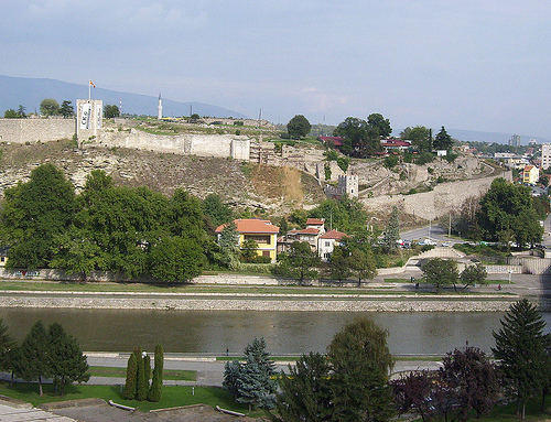
Location: Skopje Map
Constructed: 6th century AD
Kale Fortress or Skopje Fortress is a medieval citadel situated in Skopje, the capital of the Republic of Macedonia. The first human settlement dates back to the Neolithic times 6000 years ago. Roman Empire conquered these lands and established their town of Skupi. However it was destroyed in the earthquake in 518. Emperor Justinian did not wait too long and ordered construction of another military fortifications. Most of the castle that you see today was constructed in the 10th and 11th centuries. Skopje Fortress fell to the invading armies of the Ottoman Turks in the 15th century. They constructed a mosque on the citadel hill as an imposing reminder of their power. Today Kale Fortress underwent a massive reconstruction as well as archeological digs that reveals earlier layers of the castle.
How to Get There
On foot (recommended): From Macedonia Square,
cross the iconic Stone Bridge, pass through the vibrant Old Bazaar
(Çaršija), and follow signs or the crowd uphill. The walk takes
10–20 minutes and is steep in parts — a great way to experience the
bazaar’s atmosphere.
By car/taxi: There’s paid parking near the
entrance (payment often via phone/app). It’s very central, so taxis
are cheap and easy.
Public transport: Buses serve nearby areas in
the city center.
The fortress is right above the Old Bazaar, so
combine it with exploring that historic Ottoman quarter, the Stone
Bridge, and Macedonia Square.
Entrance, Hours, and Cost
Free entry — no tickets or fees.
Hours: Sources vary slightly —
generally open during daylight hours (e.g., ~7 AM–5 PM or 9 AM–7
PM). Many say it’s accessible 24/7 informally, but stick to daylight
for safety and better views.
No formal ticket booth; just walk
in.
What to Expect and See
Panoramic views: The highlight.
From the ramparts, see the Vardar River, Old Bazaar minarets, modern
Skopje (including neoclassical buildings from the Skopje 2014
project), Mount Vodno with the Millennium Cross, and distant
mountains. Sunset is especially beautiful.
Walls and towers: Walk
along restored sections of the walls (some with guardrails, but
watch for drops). There are stone steps and flat areas.
Archaeological remains: Foundations, ruins, and excavation sites
showing different historical layers.
Atmosphere: Peaceful with
locals picnicking or relaxing. It feels like a park/ ruin rather
than a museum.
Nearby: Museum of the Republic of North Macedonia
is close (some sources mention museum buildings inside, but they may
not always be open to the public).
Recommended time to spend: 45
minutes to 2 hours, depending on whether you linger for photos or a
picnic.
Best Time to Visit
Sunset — golden hour lighting
on the city and mountains is magical.
Late afternoon (e.g., 4–7
PM) to avoid midday heat.
Best seasons: Spring (May–June) and
autumn (September–October) for pleasant weather. Summers are hot
(can exceed 35–40°C/95–104°F with little shade on the hill). Winters
can be cold/foggy.
Weekdays or early mornings for fewer people.
Practical Visiting Tips
Wear comfortable shoes — paths are
cobbled, uneven, grassy, or rocky. There are stairs and inclines.
Sun protection — hat, sunglasses, sunscreen, and water. Little
natural shade on the upper areas.
Bring snacks/drinks — no
vendors or cafes inside. Picnics are popular. Eat in the Old Bazaar
before/after (try local Turkish/Macedonian spots like grilled meats
or çigköfte).
Photography — excellent for wide-angle cityscapes,
details of walls, and the Macedonian flag on towers.
Guided tours
— available via local operators or city walking tours for deeper
history. Otherwise, it’s self-guided with limited on-site info.
Accessibility — Challenging for those with mobility issues due to
uneven terrain, cobblestones, and stairs. Some areas reachable, but
not fully wheelchair-friendly. Benches available.
Safety —
Generally safe during the day. It’s a public site, so watch for
litter or overgrown areas. Avoid after dark. Skopje is overall safe,
but standard precautions apply (pickpocketing in busy tourist
spots).
Maintenance note — Many visitors note it’s somewhat
neglected (weeds, litter, unfinished projects), but the views and
historical feel make up for it.
Prehistoric and Ancient Origins
The hill has been inhabited
since the Neolithic period (roughly 4000 BC or earlier, with some
evidence from the late 5th millennium BC). Archaeological layers
reveal multiple prehistoric settlements (labeled Kale I through V in
excavations).
Kale I (Eneolithic, late 5th millennium BC):
Semi-subterranean mud huts dug into clay subsoil, with hearths,
weaving looms, storage pits, and cult pits containing figurines,
animal bones, and ritual objects. This represents an early
transition from Neolithic to Eneolithic cultures in the central
Balkans, with influences from Vinča-Pločnik and eastern Struma
Valley traditions.
Kale II (Early Bronze Age, mid-3rd millennium
BC): Above-ground houses with wooden structures, apses, and
pressed-earth floors. Open hearths and ovens were common outside.
Kale III (Middle Bronze Age, early 2nd millennium BC): Smaller
settlement on higher ground with an earthen rampart and moat (one of
the few known prehistoric examples in the region).
Kale IV (Late
Bronze to Early Iron Age transition, 12th–10th century BC): Larger
settlement with rectangular houses (some with apses), rebuilt
multiple times.
Kale V (Early Antiquity, 5th–4th century BC): Not
a full settlement but a cult/ritual site for surrounding Paeonian
communities. Archaeologists found votive offerings, sacrificial
pits, animal burials (e.g., dogs), Attic red-figure pottery, bronze
jewelry, and coins (including from Alexander III). No major Iron Age
or full Roman/early Byzantine domestic layers appear here; the area
was likely used for religious purposes by nearby villages.
The
nearby Roman city of Scupi (capital of Dardania) was destroyed by a
major earthquake in 518 AD. Builders later reused its limestone and
travertine blocks (with Latin inscriptions) for the fortress.
Byzantine Era and Medieval Period (6th–14th Centuries)
The
first major fortress was built in the 6th century AD during the
reign of Byzantine Emperor Justinian I (who was born nearby in
Tauresium). This marked the shift from the ruined Scupi to a more
defensible hilltop site. The walls used yellow limestone and
materials salvaged from the earthquake ruins.
Further
construction and reinforcement occurred in the 10th–11th centuries,
possibly over damaged Justinian-era remains due to wars. Key
developments:
The city became the capital of the First Bulgarian
Empire (992–1015) and a center for Peter Delyan's uprising against
Byzantium.
In the 11th century, "Cyclopic walls" were built.
Expansions happened under the Komnenian dynasty (12th century) and
into the 13th–14th centuries.
Under Samuel's Kingdom (late
10th–early 11th century), it was a key strategic point; some of the
oldest elements of the main city wall may date to this era (possibly
the only known Samuil walls in Macedonia).
In 1346, Serbian ruler
Stefan Dušan was crowned Emperor at the fortress and made Skopje the
capital of the Serbian Empire. Not much detailed documentation
survives about the medieval fortress's exact appearance, but it
served as a political and military center.
Ottoman Period
(Late 14th–19th/20th Centuries)
The Ottomans conquered Skopje
(Üsküp) in 1392, ruling for over 500 years. The fortress was
initially used but later neglected as a military site. It served
non-military purposes:
Warehouses, arsenals, a military hospital,
and a prison in the 19th century (and into the early 20th).
Detailed 17th-century descriptions come from traveler Evliya Çelebi.
After a major earthquake in 1555, it was repaired but lost much
defensive capability (as noted by General Piccolomini in 1689, who
described it as old-fashioned, without water or cavalry space).
Ottoman additions included gunpowder storage and watchtowers. The
site saw two stages: pre-1555 and post-1555 to the late 17th
century.
By the late Ottoman period (18th–19th centuries), it
functioned more as a support facility than a frontline fortress.
Modern Era and 20th Century
The fortress continued
military-related use into the 20th century until the Yugoslav army
left in 1951. The devastating 1963 Skopje earthquake caused massive
damage, destroying much of the fortifications, towers, and internal
buildings (similar to widespread destruction across the city).
Location and Overall Layout
The fortress sits on a dominant rocky
hill (Kale) that has been inhabited since at least the 5th–3rd
millennium BC (Eneolithic and Bronze Age settlements). The current
visible structure primarily dates to medieval and Ottoman phases, with
the core fortifications occupying the upper plateau. The site features
steep slopes, especially to the west toward the Vardar, naturally
enhancing defensibility (no need for deep trenches on that side). The
layout is roughly irregular but described historically as five-sided.
It includes:
Outer defensive walls enclosing the main area.
Inner
partition walls dividing functional zones (e.g., separating
administrative/military areas).
Towers (round and rectangular) at key
points.
Entrances/gates, including a main southern/eastern approach
with corridors and bridges over ditches.
Interior structures: Remains
of churches, residential buildings, workshops, barracks, storage (e.g.,
gunpowder rooms), and open spaces.
Materials and Construction
Techniques
Builders primarily used yellow limestone and travertine,
often quarried locally or repurposed from earlier Roman structures
(e.g., from the ruined city of Scupi after the 518 AD earthquake).
Fragments of Latin inscriptions appear in some walls.
Key
techniques evolved over time:
Byzantine/medieval core (esp. 10th–13th
centuries): Solid stone construction with mortar. The Samuil stage
(10th–11th c.) used smaller broken stones in mortar cores faced with
larger stones, sometimes separated by terracotta bricks. The later
Komneni stage (12th–13th c.) featured large, roughly dressed travertine
blocks in a cyclopean style (massive, irregular blocks resembling
ancient Mycenaean walls) bound with distinctive pink waterproof mortar.
This "pink stage" is a key chronological marker and gives the most
prominent surviving ramparts their robust appearance.
Ottoman
repairs: Continued use of stone, with additions like cobblestone
streets, new monumental towers, and reinforced entrances. Walls were
repaired after earthquakes and conquests.
Walls reached significant
heights (historically described as around 50 arshini, roughly 35+ meters
in places) with battlements and double-wall systems in parts.
Defensive Architecture: Walls, Towers, and Gates
The fortifications
were designed for strength and visibility:
Ramparts: Dominant
surviving feature, especially the northeastern and eastern sections with
cyclopean masonry. They included an outer wall and inner defenses. A
large external rampart was added in the later Ottoman period to expand
the moat/ditch system on the southern, eastern, and northern sides.
Towers: Multiple bastions (up to 70 mentioned in 17th-century accounts),
including a notable northeastern round tower with cyclopean
construction, internal frescoed chapel-like space, and defensive
features. Rectangular towers with crenellations (battlements) are also
prominent. Towers served as watchpoints, artillery platforms, and
storage.
Gates and Entrances: Main southern/eastern gates with
corridors, wooden drawbridges over trenches (lifted by windlass), and
decorative elements (arms, inscriptions). A 1446 Ottoman inscription
records repairs by a son of Mehmed. Three iron (demir) gates were noted
on the southeast.
Natural defenses (steep cliffs to the west)
complemented engineered features like deep ditches on other sides.
Evliya Çelebi's 1660 description highlights its strength: double walls
of polished chipped stone, five-sided shape, tall construction, numerous
bastions, and strategic positioning.
Interior Architecture and
Buildings
Inside the walls, the fortress evolved from a medieval
urban center (Upper Town) to a military/administrative hub:
Churches:
Foundations of a 13th-century cross-shaped church in the southeast, part
of a larger complex with associated buildings, burials, and drainage
systems. Another possible church near the northeastern tower (St.
Nicholas?). These reflect Byzantine and Serbian medieval Christian
presence.
Residential and Functional Buildings: Wooden or
brick-on-stone houses, workshops (metallurgy, weapons), storage pits,
and barracks. Ottoman phases added craft facilities, warehouses, and
military structures.
Other Features: Cobblestone streets, water
systems, and open areas. Later Ottoman use emphasized barracks and
defense.
Historical Evolution and Restorations
Early phases:
Prehistoric settlements → Byzantine reconstruction under Justinian I
(6th century), using salvaged materials.
Medieval peak: Bulgarian,
Byzantine, and Serbian rule (10th–14th centuries), with major
fortifications under Tsar Samuel and Komnenos emperors. Stefan Dušan was
crowned here in 1346.
Ottoman era (from 1392): Repairs, adaptations
for artillery/gunpowder, expansions, and damage from the 1555
earthquake. Restorations continued into the 18th–19th centuries.
Modern era: Damaged in the 1963 Skopje earthquake. Excavations
(2007–2012) revealed rich stratigraphy. Partial restorations occurred,
but a controversial 2010s church-museum project on medieval foundations
was abandoned amid ethnic tensions, leaving some unfinished structures.