Location: Gozo Map
Open: 9am- 5pm daily
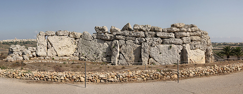
The Ġgantija Temples, located on the Xagħra plateau in the village of Xagħra on the island of Gozo, Malta, represent one of the most remarkable achievements of prehistoric human engineering. Pronounced [d͡ʒɡɐnˈtiːjɐ] in Maltese, the name translates to "place of giants" or "giantess," reflecting ancient folklore that attributed their construction to a mythical giantess named Sansuna, who supposedly built the structures while carrying her child and sustaining herself on broad beans and honey. This legend likely arose from the sheer scale of the megaliths, some weighing over 50 tons, which seemed impossible for ordinary humans to maneuver without modern technology. Dating back to approximately 3600–3200 BC during the Neolithic period, Ġgantija is part of the Megalithic Temples of Malta, a UNESCO World Heritage Site, and is recognized as the second-oldest existing man-made religious structure in the world, surpassed only by Göbekli Tepe in Turkey. These temples predate iconic monuments like the Egyptian pyramids and Stonehenge by centuries, offering profound insights into early human society, spirituality, and technological prowess.
Prehistoric Context and Origins
Malta's human habitation began
around 5900 BC, with early settlers arriving from Sicily or North
Africa, establishing farming communities that domesticated animals and
cultivated crops. By the Neolithic era, specifically the Ġgantija phase
(3600–3200 BC), these islanders had developed a sophisticated
temple-building culture unique to the Maltese archipelago. The Ġgantija
Temples were among the earliest in this tradition, constructed during a
time when the population density on the islands was remarkably high—far
exceeding that of contemporary mainland Europe—supporting several
thousand people through intensive agriculture despite challenges like
drought, storms, and soil erosion. This "Temple Culture" flourished for
about 1,500 years, producing over 30 known megalithic sites across Malta
and Gozo, each evolving independently but sharing common architectural
motifs. Ġgantija's construction around 3600 BC marks the onset of this
monumental phase, with the temples serving as focal points for a highly
organized society.
The builders were Neolithic farmers without metal
tools, wheels, or draft animals, relying on human labor and ingenuity to
quarry and transport massive limestone blocks. Archaeological evidence
suggests they used small spherical stones as rudimentary ball bearings
to move the megaliths, some exceeding 50 tons in weight—over 20 times
heavier than the average blocks in the Great Pyramid of Giza. This era
reflects a shift toward communal rituals, possibly driven by the need to
ensure fertility for both people and the land in a fragile island
ecosystem.
Construction and Architecture
Ġgantija comprises
two complete temples and the remnants of a third unfinished one, all
enclosed within a shared boundary wall made of massive upright stones
(orthostats). The larger southern temple, built first around 3600 BC,
stands about 6 meters (20 feet) tall and features a clover-leaf layout
with five semi-circular chambers (apses) arranged symmetrically around a
central corridor. The northern temple, slightly smaller and constructed
later (around 3200 BC), follows a similar design but with four apses.
Both face southeast, aligning with the equinox sunrise, akin to other
Maltese sites like Mnajdra.
Materials were sourced locally:
hard-wearing Coralline Limestone for the external walls and softer
Globigerina Limestone for intricate interior elements, such as doorways,
altars, and decorative slabs. The walls were filled with rubble between
inner and outer faces, and evidence of corbelled roofing suggests the
apses were once covered. Interior walls bore plaster coated with red
ochre paint, and decorative features included bas-relief spirals,
drilled holes, and motifs of trees, plants, and animals—hallmarks of
Maltese megalithic art. At the entrance, a recessed stone block may have
functioned as a ritual ablution station for purification before
ceremonies. The site's elliptical forecourt and concave façade exemplify
the diversity and sophistication of Maltese temple architecture,
requiring considerable technical skill given the limited resources.
Purpose and Cultural Use
Archaeologists interpret Ġgantija as a
ceremonial complex dedicated to fertility rites, likely centered on a
mother goddess cult symbolizing life, reproduction, and agricultural
abundance. Excavations uncovered numerous female figurines and statues,
including carvings resembling the Paleolithic Venus of Willendorf,
emphasizing themes of fertility. Animal bones found in the apses
indicate ritual sacrifices, possibly to invoke prosperity for crops and
livestock. The temples' design, with altars in the apses, suggests they
were venues for communal gatherings and spiritual practices,
underscoring a highly organized, ritual-focused society. Connections to
nearby sites, like the Xagħra Stone Circle (a hypogeum used for
burials), highlight Ġgantija's role in a broader sacred landscape. Some
theories propose astronomical alignments, though evidence is limited
beyond the equinox orientation.
Decline and Abandonment
The
Temple Culture peaked around 3000–2500 BC but abruptly declined
thereafter, with Ġgantija falling into disuse by approximately 2500 BC.
The third temple's incomplete facade suggests construction halted
mid-process. Environmental factors, including prolonged drought, violent
storms, soil erosion, and resource depletion on the isolated islands,
likely contributed to societal collapse. Overpopulation may have
strained the fragile ecology, leading to famine or migration. By the
Bronze Age, new influences arrived, but the megalithic tradition
vanished, leaving the temples abandoned for millennia.
Rediscovery, Excavations, and Modern Preservation
Awareness of
Ġgantija persisted into the late 18th century, with French artist
Jean-Pierre Houël producing an accurate plan around 1770. In 1827,
Lieutenant Governor Col. John Otto Bayer cleared debris, but without
systematic study, much material was lost; artist Charles Frederick de
Brocktorff documented the site pre-clearance. The ruins decayed until
included on Malta's Antiquities List in 1925. The government
expropriated the land in 1933, initiating major excavations in 1933,
1936, 1949, and 1956–1959 to clear, preserve, and research the site.
UNESCO inscribed Ġgantija in 1980, expanding the listing in 1992 and
2015 to encompass all Megalithic Temples of Malta. Restoration in the
2000s included protective shelters, lightweight walkways (installed
2011) to prevent floor damage, and the opening of the Ġgantija Heritage
Park in 2013. Managed by Heritage Malta under the Cultural Heritage Act
(2002), the site features an Interpretation Centre with artefacts,
audiovisuals, and exhibits on Neolithic life. Today, it attracts
visitors for its educational value, with ongoing conservation ensuring
its survival as a window into humanity's distant past.
According to legend, a giantess is said to have erected the building in a single night while still holding her child in her arms.
Location and Overview
The Ġgantija Temples are a prehistoric
megalithic complex located in the village of Xagħra on the island of
Gozo, part of the Maltese archipelago in the central Mediterranean Sea.
Gozo, the second-largest island in Malta, lies approximately 6
kilometers northwest of the main island of Malta and covers an area of
about 67 square kilometers. The temples are situated at the coordinates
36°02′50″N 14°16′09″E (or approximately 36.04725°N, 14.26903°E), making
them easily accessible from the island's capital, Victoria (also known
as Rabat), which is about 3 kilometers to the west. This positioning
places Ġgantija roughly 90 kilometers south of Sicily and at the heart
of the Mediterranean, contributing to its role in ancient maritime and
cultural networks.
Gozo itself is characterized by a hilly, terraced
landscape with fertile valleys, coastal cliffs, and a rugged shoreline
indented by bays and inlets. The island's geology is dominated by
layered limestone formations, which have shaped its topography through
erosion and karst processes, creating plateaus, valleys, and natural
harbors. Unlike the more urbanized main island of Malta, Gozo is notably
more rural and agriculturally productive, supporting crops like grapes,
olives, figs, and vegetables due to its richer soil and higher rainfall.
The surrounding Mediterranean Sea influences the island's mild climate
and provides distant views from elevated sites like Ġgantija, where the
sea is visible on clear days.
The Xagħra Plateau and Site
Topography
The temples occupy a prominent position on the Xagħra
plateau, a broad, elevated limestone tableland in eastern Gozo that
forms one of the island's key archaeological landscapes. Described as an
"extraordinary archaeological landscape," the plateau rises to about
140-150 meters above sea level and spans several square kilometers,
featuring a mix of flat expanses, gentle slopes, and scattered rock
outcrops. Ġgantija is specifically at the southeastern edge of this
plateau, facing southeast toward lower-lying areas and offering
panoramic views over the surrounding countryside and toward the sea.
This edge location provides a sense of prominence and isolation, with
the site overlooking fertile valleys and terraced fields that descend
toward the coast.
Topographically, the area around Ġgantija features
slopes ranging from 4 to 14 degrees, a pattern observed across many
Maltese temple sites. These slopes are not the steepest or highest
points on the plateau but are chosen for their balance of visibility and
accessibility. The site itself is relatively flat within the temple
complex but benefits from the plateau's natural elevation, which
enhances intervisibility with other prehistoric sites on Gozo and Malta.
For instance, Ġgantija is geographically linked to nearby funerary
complexes like the Brochtorff Circle (also known as the Xagħra Circle),
a hypogeum burial site just a short distance away, suggesting
intentional spatial relationships between temples and ritual landscapes.
The plateau's terrain is karstic, with underlying caves, fissures, and
water channels that have influenced prehistoric settlement and
construction.
Geological Features
Geologically, Ġgantija and
the Xagħra plateau are composed of Malta's characteristic Oligo-Miocene
limestones, which form the backbone of the archipelago's stratigraphy.
The temples are built primarily from locally quarried Coralline
Limestone, a hard, durable rock used for the outer walls and megaliths,
some of which weigh over 50 tonnes and stand up to 6 meters high. Softer
Globigerina Limestone, known for its workability and golden hue, was
employed for interior elements like altars, doorways, and decorative
slabs. These materials reflect the island's sedimentary geology, formed
from ancient marine deposits, with layers including Upper Coralline
Limestone capping the plateau and providing resistance to erosion.
The site's geology also ties into broader environmental features: Gozo's
limestone is highly permeable, leading to limited surface water and
reliance on underground aquifers, which may have influenced prehistoric
water management and ritual practices. Erosion has sculpted the plateau
over millennia, creating natural boundaries and quarries that supplied
building materials directly from the landscape.
Climate and
Environmental Significance
Gozo experiences a Mediterranean climate
with hot, dry summers (average highs of 30-32°C from June to August) and
mild, wet winters (averages of 10-15°C from December to February),
receiving about 600 mm of annual rainfall—slightly more than Malta's
main island due to orographic effects from its hills. This climate
supports diverse vegetation, including maquis scrub, garigue with herbs
like thyme and rosemary, and agricultural fields that surround the site
today. Prehistorically, the area may have been more wooded, but
deforestation for farming and construction likely altered the landscape
by the Neolithic period.
Environmentally, Ġgantija's geography holds
significance as part of a UNESCO World Heritage Site cluster (Megalithic
Temples of Malta), highlighting its role in understanding prehistoric
human-environment interactions. The plateau's fertility and strategic
elevation likely made it ideal for early farming communities, while its
proximity to the sea (about 2-3 kilometers to the northeast coast)
facilitated trade and fishing. Modern threats include urban encroachment
and tourism pressure, but the site's elevated position aids in
preservation by reducing flood risks.
Orientations and
Geographical Alignments
A key aspect of Ġgantija's geography is its
intentional alignment with the landscape and sky, particularly during
the Ġgantija phase (3400–3100 BC). The temples face southeast (azimuths
around 130° and 200°), prioritizing views of the southern horizon while
restricting northern visibility. This orientation favors slopes with
high inter-site visibility but avoids hilltops or extreme inclines.
Statistical analyses show non-random patterns, with declinations between
-33.7° and -28.1° aligning with the rising or setting of southern stars
like Hadar (Beta Centauri), Gacrux (Gamma Crucis), and possibly
Avior—visible low on the horizon (1-4° altitude) under prehistoric
atmospheric conditions. These celestial ties suggest the site's
geography was chosen for astronomical observations, possibly linked to
seasonal rituals or navigation, distinguishing Ġgantija from later
Tarxien-phase temples which lack such strong patterns.