Location: Møre og Romsdal County Map
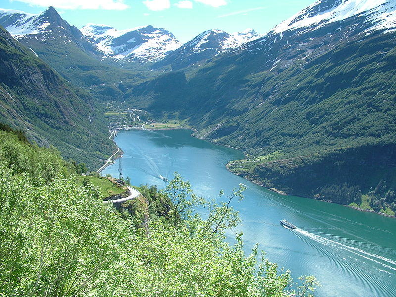
Geiranger Fjord, known in Norwegian as Geirangerfjorden, is a breathtaking 15-kilometer-long fjord located in the Sunnmøre region of Møre og Romsdal county in southwestern Norway. It branches off from the larger Storfjord system, extending inland to the small village of Geiranger at its head, where the Geirangelva River empties into it. Situated about 60 kilometers inland from the coast and roughly 240 kilometers northeast of Bergen, this fjord is nestled amid dramatic landscapes that have earned it UNESCO World Heritage status since 2005, alongside the nearby Nærøyfjord, as part of the West Norwegian Fjords site. Recognized for its archetypal fjord scenery, Geiranger exemplifies the raw power of glacial formation, with its exceptional natural beauty often ranking it among the world's most spectacular places, including being named the best travel destination in Scandinavia by Lonely Planet. The fjord's allure lies in its harmonious blend of deep blue waters, towering cliffs, cascading waterfalls, lush vegetation, and snow-capped peaks, creating a fairytale-like environment that draws millions of visitors annually.
Geiranger Fjord, also known as Geirangerfjord, is a stunning natural
feature located in southwestern Norway, specifically in the Sunnmøre
region of Møre og Romsdal county within Stranda Municipality. It forms a
15-kilometer-long branch of the larger Storfjorden system, extending
from the village of Hellesylt at its outer end to the small tourist
village of Geiranger at its head. This fjord is part of a vast fjord
landscape that stretches approximately 500 kilometers from Stavanger in
the south to Åndalsnes in the northeast, and it is renowned for its
dramatic scenery, which has earned it UNESCO World Heritage status as
part of the West Norwegian Fjords – Geirangerfjord and Nærøyfjord site.
The name "Geiranger" derives from Old Norse, combining "geirr" (spear)
and "angr" (fjord), likely alluding to the fjord's elongated, spear-like
shape.
Geographically, the fjord is positioned about 100 kilometers
inland from the coastal city of Ålesund and roughly 120 kilometers from
the similarly protected Nærøyfjord to the south. Its remote setting,
nestled among steep mountains with the fjord serving as the primary
access route, has historically isolated the area, influencing its
development and culture. The surrounding terrain includes protected
areas like the Geiranger–Herdalen Landscape Protection Area, as well as
nature reserves such as Kallskaret and Hyskjet, emphasizing its
ecological significance.
Geological Formation and Landscape
The geography of Geiranger Fjord is a quintessential example of glacial
sculpting, formed over multiple ice ages when massive glaciers eroded
deep valleys into the bedrock, creating the fjord's U-shaped profile and
the towering mountains that flank it. This process involved repeated
cycles of glaciation, where ice sheets advanced and retreated, carving
out the fjord while depositing moraines and shaping the rugged peaks.
The underlying geology consists primarily of crystalline rock, including
gneiss and granite, which contributes to the steep, sheer walls that
define the fjord's dramatic silhouette.
Submarine moraines—underwater
ridges formed by glacial debris—are present beneath the surface, adding
to the fjord's complex bathymetry. The landscape's verticality is
extreme: the fjord walls rise up to 1,400 meters directly from the
Norwegian Sea, while extending about 500 meters below sea level in
places. This results in one of the world's longest and deepest fjords,
with Geirangerfjord itself reaching depths of up to 260 meters. The
combination of these elements creates a microclimate that supports lush,
green vegetation on the lower slopes, contrasting with snow-capped peaks
higher up, even in summer.
The fjord's formation has also led to
ongoing geological activity, including the risk of rockslides from
unstable mountainsides like Åkerneset, which could potentially generate
tsunamis—a concern monitored by Norwegian authorities. Overall, the
area's natural diversity stems from the short horizontal distance from
sea level to summits exceeding 1,600–1,700 meters, allowing for a rapid
transition through various ecological zones.
Physical Dimensions
and Hydrology
Geiranger Fjord spans approximately 15 kilometers in
length and varies in width from as narrow as 250 meters in some sections
to up to 2.5 kilometers in broader areas, typical of western Norwegian
fjords. Its maximum depth of 260 meters creates a stratified water
column, with freshwater from rivers and waterfalls overlaying denser
saltwater, influencing local marine ecosystems.
Hydrologically, the
fjord is fed by numerous rivers and streams originating from the
surrounding highlands, which receive heavy precipitation due to the
orographic lift from Atlantic weather systems. This results in an annual
water inflow that maintains the fjord's brackish surface layer. Notable
tributaries include those feeding iconic waterfalls, which cascade
directly into the fjord from heights of hundreds of meters. The fjord
connects outward to Sunnylvsfjord and Tafjord, forming part of a larger
interconnected system.
Notable Geographical Features
The
fjord's most striking features are its waterfalls, which tumble down the
precipitous cliffs in misty veils. Prominent examples include De Syv
Søstrene (The Seven Sisters), a series of seven streams dropping 250
meters; Friaren (The Suitor), positioned opposite and named for its
"wooing" appearance; and Brudesløret (The Bridal Veil), a thin, ethereal
fall that resembles a veil. These are best viewed from the water or
viewpoints along the fjord's edges.
The surrounding mountains, such
as those in the Geiranger–Herdalen area, feature plateaus and valleys
carved by glaciers, with elevations reaching over 1,700 meters.
Abandoned mountain farms, like Skageflå, cling to ledges high above the
fjord, illustrating human adaptation to this vertical terrain. Roads
like Ørnevegen (Eagle Road) wind through hairpin bends, offering
panoramic vistas from points like Ørnesvingen, where the fjord's
serpentine shape is fully appreciable.
Wildlife adds to the
geography's dynamism: colonies of seals and porpoises inhabit the
waters, while the steep slopes support diverse flora, from alpine
species at higher elevations to fertile valleys below. The fjord's
aesthetic appeal—often described as among the most beautiful on
Earth—stems from this interplay of water, rock, and vegetation.
Best Time to Visit
Early summer (May–June): Waterfalls are at
their most powerful from snowmelt. Roads are clear, and crowds are
lighter than midsummer.
Midsummer (July–August): Warmest and
brightest, with long daylight hours (nearly midnight sun). Ideal for
hiking and boating, but busiest with cruise ships.
September: Fewer
crowds, beautiful autumn colors, but cooler weather and some services
may close. Roads like Trollstigen can close earlier.
Avoid
October–April unless seeking winter adventures (limited access, snow,
fewer facilities). Many roads and attractions are seasonal.
Weather
is changeable—pack layers, rain gear, and sturdy waterproof hiking
shoes.
How to Get There
By car/road trip: Most scenic option.
Drive the Norwegian Scenic Routes, including Trollstigen (hairpin bends,
open summer) and Eagle Road (Ørnevegen). From Ålesund, it’s a few hours
with ferries. Rent a car for flexibility.
By ferry/cruise:
Popular—ships dock right in Geiranger. The Hellesylt–Geiranger ferry
offers great views (about 65–90 minutes). RIB speedboats or sightseeing
cruises provide closer waterfall access.
Public transport: Buses from
Ålesund or other hubs; combine with ferries.
Tip: Drive or arrive
early/late to avoid cruise ship crowds (typically 10 AM–4 PM).
Top Things to Do
Boat on the Fjord (Essential): Take a 75–120 minute
sightseeing cruise or RIB safari for close-up views of waterfalls and
cliffs. Kayaking is calmer and more immersive. Book ahead.
Viewpoints
from Above:
Flydalsjuvet: Iconic photo spot overlooking the village
and fjord (hike or short drive).
Ørnevegen (Eagle Road): Hairpin
bends with balcony viewpoints.
Dalsnibba / Geiranger Skywalk: 1,500m
above sea level—epic panoramas (toll road, open seasonally).
Hiking (Highly Recommended):
Fosseråsa National Hiking Trail (to
Storsæterfossen): Starts in town, passes behind a waterfall.
Moderate-strenuous; rewarding views.
Skageflå Farm: Boat one way +
steep 45-min hike (or full loop). Historic abandoned farm with
incredible vistas.
Shorter: Waterfall walk (327 steps) to Norwegian
Fjord Centre or Vesterås Farm trail.
Norwegian Fjord Centre:
Learn about fjord geology, history, and culture. Good for rainy days or
families.
Other Adventures: Zipline, via ferrata, e-bike to
Dalsnibba, or guided tours.
Pro Tip: Experience the fjord from
multiple angles—boat (water level), hike (mid-level), and viewpoint
(above)—for the full effect.
Where to Stay
Geiranger village
is touristy and crowded; consider staying higher up or nearby for better
views and peace.
Hotel Union Geiranger: Historic, upscale with spa,
pool, and fjord views. Top pick for comfort.
Hotel Utsikten or Grande
Fjord Hotel: Excellent elevated views.
Outside Geiranger (e.g.,
Valldal): Quieter cabins or hotels with strawberry fields and fewer
crowds. Great if you have a car.
Book early—peak season fills fast.
Look for fjord-view rooms.
Practical Tips
Crowds & Timing:
Cruise ships dominate midday. Visit viewpoints/hikes early morning or
evening. Midweek or shoulder season is better.
Parking & Mobility:
Limited in town, especially on cruise days. Use hop-on hop-off buses,
taxis, or e-bikes for viewpoints if not driving/hiking.
Costs: Norway
is expensive. Expect high prices for boats (~NOK 500+), meals, and
lodging. Book activities in advance via official sites like
visitgeiranger.com or geirangerfjord.no.
Safety & Preparation:
Trails can be steep/slippery—wear proper boots.
Drone restrictions
apply in many areas.
Respect nature: Stick to paths, no littering
(Allemannsretten allows wild camping but follow rules).
Limited
nightlife; focus on nature.
Food: Try local seafood, berries, or
hotel breakfasts. Options are tourist-oriented but quality.
Sustainability: As a UNESCO site, minimize impact. Support local
operators.
For cruise visitors (4–6 hours): Prioritize a short
RIB/kayak, waterfall walk + Fjord Centre, and one viewpoint (taxi or
bus).
The fjord's visual drama is amplified by its numerous waterfalls, which tumble from the cliffs in misty veils, often named poetically to reflect their appearances. The most famous is De syv søstrene (The Seven Sisters), a series of seven streams plunging over 250 meters into the fjord, creating a hazy spectacle especially vivid during the melt season. Opposite it stands Friaren (The Suitor), a single fall that appears to "woo" the sisters across the water, while Brudesløret (The Bridal Veil) drapes delicately over the rocks like lace. Other notable cascades include the Storsæter waterfall, accessible via the Fosseråsa national hiking trail, where visitors can walk behind the thundering flow. The fjord's cliffs also host abandoned mountain farms such as Skageflå, Knivsflå, and Blomberg, perched precariously hundreds of meters up, remnants of a hardy agricultural past where farmers navigated avalanches and isolation. These sites, now preserved, offer panoramic views and highlight the fjord's verticality, where lush green vegetation clings to near-vertical slopes amid snow-covered peaks. Underwater, the fjord supports marine life adapted to its brackish mix of fresh and saltwater, including fish species and occasional seals, though the focus remains on its above-water grandeur.
Geological Formation: The Ice Age Legacy
The fjord's origins trace
back at least 2.5 million years to the Pleistocene epoch and earlier
tectonic uplift along the North Atlantic's rifted margin. During the
Tertiary period, the land was lifted and tilted westward, creating
drainage systems that were later deeply eroded by successive Ice Age
glaciers. Norway was covered in ice until around 10,000 BC; as glaciers
advanced and retreated over multiple cycles, they carved U-shaped
valleys out of Precambrian gneisses of the West Gneiss Region (an area
of deeply subducted continental crust with high-pressure rocks like
eclogites). When the ice finally melted, seawater flooded these valleys,
forming the classic fjord landscape.
This process left behind
polished bedrock, submarine moraines, hanging valleys, avalanche
deposits, and active geological features still visible today. The area
serves as a "natural history laboratory" for studying glacial erosion,
postglacial isostatic rebound, and ongoing slope instability. The
fjord's narrow form (max. width 1.5 km) and sheer walls exemplify the
type locality for fjord landscapes worldwide.
Prehistoric and
Early Human Settlement
Evidence of human activity dates to the Stone
Age and Bronze Age, with archaeological finds around the fjord
indicating small communities exploited its resources for fishing,
hunting, and foraging. By the Iron Age and Viking period (roughly
800–1050 AD), settlement was established. Burial mounds at the Vinje
farm above the fjord provide direct evidence of Viking-era presence. The
name "Geiranger" derives from Old Norse geirr ("spear") and angr
("fjord" or "inlet"), likely referencing the fjord's long, tapered shape
or nearby mountain fields—reflecting deep Norse roots. Farm names
scattered across the hillsides further tie the area to Viking heritage.
Geiranger served as a natural meeting and trading hub: coastal people
exchanged fish, hides, and salt for inland grain and livestock at sites
like Merok on the shore. This geography-driven economy persisted for
centuries.
Medieval and Early Modern Farming Life: Isolation and
Resilience
From the medieval period (c. 1000–1500 AD) through the
early modern era, Geiranger remained a small, isolated farming village.
Christianity arrived early; a chapel likely existed by the mid-15th
century, with the first recorded church (possibly a stave church) noted
as old by 1589. It was administratively part of the Norddal parish,
requiring arduous boat or mountain journeys for regional gatherings.
Life revolved around subsistence farming on terraced mountainside plots
and steep ledges. Livestock (goats, sheep, cows) grazed high pastures,
while families carved out arable land wherever possible. Farms like
Skageflå (about 250 meters above the fjord, inhabited from medieval
times until 1916, with haymaking into the 1960s) and Knivsflå (opposite
the Seven Sisters, settled from the 1600s and abandoned in 1898 due to
rockfalls) exemplified the extreme conditions. Residents navigated
narrow, precipitous paths and iron-bolted bridges; legend says parents
tethered small children with ropes to prevent falls from cliffs. A 1873
rockslide damaged parts of Skageflå, yet families persisted, raising up
to 120–125 goats alongside other animals.
Over 350 historic
buildings, including these transhumant (seasonal) farms, highlight human
adaptation to the landscape's hazards—avalanches, rockslides, and
isolation. The fjord was the primary transport route; overland travel
was limited until modern times. This isolation fostered tight-knit
communities and unique local traditions.
19th Century: Opening to
the World and the Birth of Tourism
The 19th century marked a profound
shift. In 1858, scheduled steamships began calling at Geiranger,
providing the first regular link to Ålesund and beyond. This enabled
export of dairy and wool while importing goods.
Tourism arrived in
1869 with the British Backhouse family aboard their yacht Nereid—the
first recorded cruise visitors. They explored as naturalists, taking
what were likely Geiranger's first photographs. Locals, initially
puzzled, adapted quickly: farmer Martinius Merok opened a small
inn/store at Maråk (later Merok's Hotel), which doubled as a barn.
Road engineering accelerated the boom. The Geiranger Road (completed
1889) connected the village via hairpin turns to inland routes, followed
by extensions in 1894. Hotels sprang up: Hotel Geiranger (1880s
origins), the grand Hotel Union (1893), and others with panoramic views.
Cruise ships increased dramatically—from about 39 in 1888 to 70 annually
by 1898–1900.
Kaiser Wilhelm II of Germany was a pivotal figure. In
1890, he arrived with three royal ships, becoming the first reigning
monarch to visit. Enchanted, he returned nearly every summer until World
War I, elevating Geiranger's fame among Europe's elite as the "pearl of
the Norwegian fjords."
20th Century to Present: Tourism
Dominance, Farm Abandonment, and Preservation
Tourism continued
expanding in the early 20th century, with locals supplementing farming
income through guiding, handicrafts, and transport. The village
population hovered around 400 by 1900, but many mountain farms were
abandoned mid-century due to harsh conditions, rockslides, and economic
opportunities elsewhere—many residents emigrated to America. The last
farms ceased active use by the mid-1900s; today they are protected
cultural sites.
World War II brought occupation, but post-war
infrastructure (e.g., the Eagle Road in 1954) further boosted access. By
the late 20th century, Geiranger had become one of Norway's most visited
sites, with cruise ships and the Geiranger–Hellesylt ferry as key
attractions. The Norwegian Fjord Centre now educates visitors on the
heritage.
In 2005, Geirangerfjord and Nærøyfjord were jointly
inscribed as the "West Norwegian Fjords" UNESCO World Heritage Site
(criteria vii for outstanding natural beauty and viii for geological
processes). The designation recognizes the dramatic glacial landscape
alongside cultural elements like the abandoned transhumant farms, which
add human scale without detracting from nature. It emphasizes
preservation amid tourism pressures.
Modern challenges include
overtourism from cruise ships (prompting zero-emission requirements by
2026), landslide risks from Åkerneset mountain (which could trigger a
megatsunami), and climate impacts. The area inspired cultural works like
Disney's Frozen and the film The Wave (depicting a fictional rockslide
disaster).
Geiranger Fjord offers a wealth of experiences centered on its natural splendor. Boat cruises from Geiranger or Hellesylt provide intimate views of the waterfalls and cliffs, often getting close enough to feel the mist from The Seven Sisters. Hiking trails abound, such as the steep ascent to Skageflå farm from Skagehola landing, rewarding trekkers with fjord vistas and historical insights. Viewpoints like Flydalsjuvet offer iconic overlooks of the fjord's serpentine shape, while the nearby Trollstigen road— a hairpin-turn marvel—leads through the Romsdalen Alps for panoramic drives. In winter, the area transforms for snowshoeing and cross-country skiing, though summer (June–August) is peak season for lush greenery and midnight sun. Nearby Ålesund, with its Art Nouveau architecture, complements fjord trips via scenic rail journeys like the Rauma Railway. Conservation is key, with protected zones safeguarding the ecosystem from overtourism, ensuring future generations can appreciate this jewel of Norway's fjords.