Height: 3,000 ft (900 m)
Maximum width: 3 mi (5 km)
Depth: 3, 960 ft (1,200 m)
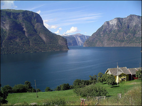
Sognefjord is the largest fjord in Norway that is
situated in Sogn og Fjordane County. It is also the third longest in
the World stretching for 205 kilometres (127 mi) all the way to a
innermost arm of Lustrafjord that leads to a small village of
Skjolden. Tourist cruise ships travel through the whole distance and
makes stops in several locations allowing visitors to explore
medieval villages and structures along a way. This include several
stave wooden churches including Borgund Church, Kaupanger Church,
Urnes Church and many others.
The formation of the
Sognefjord began 2.57 million years ago during the Pleistocene. As a
result of erosion caused by the convergence of glaciers, the river
system turned into a fjord. At the same time, 7610 km³ of rock was
destroyed over the entire area of the Sognefjord basin, which
currently stands at 12,518 km². The average depression caused by
erosion was 610 meters, and the maximum (in the eastern part) - 2850
meters. Annual erosion rates reached 2 mm per year.
The
inner part of the fjord lies on the leeward side of high mountains
like Breheimen (with the glacier Jostedalsbreen). Therefore, there
is a significant difference in climate between pronounced maritime
climate at the mouth into the open sea and continental climate at
the inner end of the fjord and its side arms. Below the mouth of the
fjord is a rocky outcrop that only lets the warm water from the
North Sea flow into the fjord. As a result, the climate is mild and
allows, especially on the north shore, extensive fruit cultivation.
The Sognefjord region is a UNESCO World Heritage Site and has
been attractive to tourists for a long time. It offers various
national parks, such as the Jotunheimen National Park, the
Jostedalsbreen Glacier National Park and the valleys Aurlandsdalen
and Utladalen. The highest mountain pass in northern Europe, the
Sognefjellsveien, runs through the Jotunheimen National Park.
Another attraction point is the Vettisfossen in Øvre Årdal, with 275
meters free fall one of the highest waterfalls in Norway.
In
addition to scenic features, there are numerous culturally
interesting offers. The award-winning Norwegian Glacier Museum in
Fjærland, a wild salmon center or Norway's oldest stave church,
Urnes Stave Church are among them.
Scenically, this part of
Norway is one of the most popular hiking regions in Norway. Glacier
hikes, kayaking on fjords and glacial lakes and cruises or fjord
cruises are some of the popular outdoor activities.
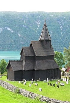
Location: Ornes Farm Map
Urnes Stave Churh is situated on the Ornes Farm along an innermost arm of Sognefjord known as Lustrafjord. It was completed somewhere in the early 12th century.
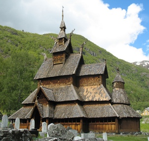
Location: Borgund, Lærdal Map
Borgund Stave Church is a medieval wooden church situated on the shores of Sognefjord near a village of Borgund, Lærdal. It was constructed in the 12th century. In addition to usual European Christian symbols it also contains several inscriptions using traditional runic writing.
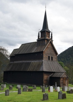
Location: Sogn og Fjordane County Map
Kaupanger Stave Church is a another medieval church in the Sognefjord that was constructed in the mid 12th century.
From the inner parts of Årdal or Skjolden, the fjord gradually becomes deeper outwards (westwards). The deepest part is approximately at Åkrestrand and Vadheim. The outer part of the fjord (at Losna and Sula) has a marked threshold with depths of 100 to 200 meters, where the fjord bottom rises abruptly from 1200 meters deep to about 100 meters. In Sognesjøen there are several small troughs (with depths down to 400-500 meters) with thresholds in between. Across the fjord, the bottom is partly completely flat with less than 1 meter variation in depth of 2 km cross section. The bottom is covered with fine material (clay) which at Vangsnes is up to 300 meters thick. Between 50 and 180 km from the mouth, the fjord bottom is relatively flat. Almost all the side fjords form hanging valleys to the main fjord. For example, the mouth of the Fjærlandsfjord is about 400 meters deep while the main fjord is close to 1200 meters deep just outside the mouth. The mouth of the Vadheimfjord is 400 meters deep. The mouth of the Ikjefjord is only 50 meters deep close to where the main fjord is at its deepest. In large parts of the fjord, it is "abysmal" in that the steep mountain sides continue just as steeply under water.
Terrain formations and
distance to the sea lead to large variations in climate along the
fjord. The amount of precipitation decreases sharply inland in the
fjord. Lærdal is located in the rain shadow and has very little
precipitation, while west-facing slopes further out have a lot of
precipitation and there the precipitation often increases with
altitude. Brekke and Takle in Ytre Sogn are among the places in
Norway with the most precipitation. North of the Sognefjord is the
Jostedalsbreen glacier, Norway's largest glacier, and parts of the
meltwater drain into the Sognefjord. Wind conditions are strongly
affected by terrain formations. In winter, the dominant wind
direction is out into the fjord or out the side valleys in the form
of so-called downwinds. The falling winds can be very strong and
have great significance for cooling and icing. The slopes and
valleys along the inner parts of the fjord have a partly mild
climate and fruit bar which makes the area suitable for growing
fruit and berries, among other things. The slopes along the fjord
have partly large coniferous forest, for example in the roadless
area of Frønningen.
The fjord receives fresh water mainly
from the rivers and very little precipitation directly on the
fjord's water level. In the inner part of the Sognefjord, the total
supply of fresh water during a year corresponds to a depth of 33
meters if it were distributed over the entire area of the fjord.
In the spring and partly in the autumn, the upper 2-3 meters of the
fjord are brackish water, especially in the side fjords. The salt
content of the surface is at least summer and autumn. In June 1954,
for example, 5 ‰ salt was measured in the upper meter of the
Lustrafjord, while at great depths it was 34.5 ‰. Regulation of the
watercourses for power production has led to a larger part of fresh
water flowing into the fjord during the winter.
Jostedøla's
material transport (in the form of sludge) involves a sedimentation
in the Gaupnefjord of 10 to 20 cm / year near the river estuary, and
1 cm / year 2 km from the river estuary. The river transports 50,000
to 100,000 tons of sludge annually. The sludge concentration from
Jostedøla is at most 1 g / liter. It is especially at Gaupne that
the melt water from the glaciers is noticeable on the water color.
In the Sognefjord, incoming current is not very noticeable and
is felt most by strong westerly winds. Outgoing current dominates
and is particularly strong in spring and summer.
The
watercourses Lærdalselvi, Aurlandselvi, Flåmselvi, Mørkridselvi,
Henjaelvi, Grindselvi, Hamreelvi, Njøsaelvi, Kvinnafossen,
Sogndalselvi and Jostedøla flow into the Sognefjord and have normal
spring floods in June. Årdalsvatnet drains to the Sognefjord through
the short Åreidselva or Hæreidselvi through Årdalstangen. Eidsvatnet
in Luster drains to the Sognefjord near Mørkridselvi in Skjolden.
The Sognefjord has herring and good sprat fishing. In the outer parts of the fjord, salmon has traditionally been fished with wedge nets. Salmon warp or "sitjenot" is a traditional method for salmon fishing and skilled fishermen could catch a lot of fish with this method. Hook nets and drift nets have dominated in modern times and do not require the same active fishing as warp. The salmon's migration in the fjord is controlled by currents in the surface and the warps are located where there are favorable current conditions where the salmon is driven close to land on their way into the fjord due to the current. In Leikanger and Balestrand there are many good places for sitejnot with Suppham as the clear best. Good salmon rivers such as Lærdalselva, Aurlandselva and Årøyelva flow into the Sognefjord.
The Sognefjord has
been an important transport artery since ancient times. Gulatinget
was probably held near the mouth of the Sognefjord and probably
because it was convenient to hold the thing where the shipping lane
along the coast met the large fjord. From the innermost arms of the
fjord, there is a relatively short distance to the inner settlements
in Eastern Norway, especially through Lærdal to Valdres over the
moderate mountain pass Filefjell. From the 17th century, Lærdalsøyri
was an important market and meeting place. There, farmers from
Valdres, Hallingdal and Gudbrandsdalen sold slaughter, tar and other
products from the interior and bought fish, salt, hemp and iron from
the fjords and from Bergen. Around the year 1300, the authorities
established a shuttle station on Maristova at the entrance to
Filefjell. The first drivable road between east and west was built
over Filefjell in 1792. From 1843, the wheeled steamer
"Constitutionen" went on a route between Bergen and Lærdal, the
county boats took over the route in 1857. The traffic road over
Sognefjellet was built as a road in 1938. In 1940, the Flåm line
connected the Sognefjord to the railway network. Stalheimskleivi,
between Voss and Sogn, was built in 1850 and turned into a road in
1937. It has made it possible to transport agricultural products,
fruit, berries and fish between the villages in Sogn and Bergen.
Three national roads cross the fjord by car ferry:
E39
between Lavik and Oppedal
Highway 13 between Vangsnes and
Dragsvik
Highway 5 crosses the fjord by car ferry between
Mannheller and Fodnes
E16 touches the Sognefjord's side fjords at
Gudvangen, and between Flåm and Aurland.
There are six ferry
connections that cross the fjord:
Mannheller – Fodnes
Hella –
Dragsvik – Vangsnes
Lavik – Oppedal (E39)
Rysjedalsvika –
Rutledal – Krakhella
Solvorn – Ornes
Ortnevik – Måren –
Nordeide
With the exception of the private Tindevegen, there
is no road connection between the north side and the south side of
the fjord, the vehicles are transported by ferry. On behalf of the
government, the Norwegian Public Roads Administration has initiated
studies on a permanent road crossing of the fjord. Due to the great
depth of the fjord, it is not technically possible with an
underwater tunnel. Instead, the agency is considering two
alternatives: a floating bridge and a pipe tunnel a few tens of
meters below sea level. The proposed fjord crossing will be included
in Ferry-free E39 between Kristiansand and Trondheim.
There
are daily express boat routes from Sogndal to Bergen and Selje in
Nordfjord.
There are ports for cruise ships in Flåm and in
Skjolden.
Flåmsbana, the only railway line in the county, has
a terminus in Flåm by the Sognefjord. When the Bergen line was
adopted, a siding to the Sognefjord was planned to connect Sogn to
the railway network.
The Sognefjord was established as a tourist destination in the 19th century, including the establishment of the county boats. One of the targets was Gudvangen, which in 1889 received 79 large tourist ships with a total of over 10,000 passengers. In 1889, 4,500 passengers came with the county boats. The German emperor Wilhelm visited the Sognefjord and Balestrand for the first time in 1890. The emperor then visited the Sognefjord 25 times. The fjord itself and the surrounding area with Jotunheimen, Jostedalsbreen and several stave churches have made the Sognefjord one of Norway's most distinct tourist destinations. Balestrand, Vangsnes, Aurland and Fjærland were among the early destinations for English tourists in the 19th century.
From 1785, the Trondheim postal road crossed the
Sognefjord by boat between Rutledal and Leirvik in Hyllestad. In
1647, a postal route was established between Bergen and Christiania.
The post office then spent 7-8 days on Gudvangen, Lærdal and
Valdres.
The county boats were established in 1858 with boat
routes on the Sognefjord and to Bergen as an important activity.
In 1934, a ferry route was established along the fjord from
Vadheim to Lærdal. From 1939 until the Lærdal tunnel opened, there
was a car ferry between Gudvangen and Lærdal - first the ferry went
to Lærdalsøyri itself, from 1966 to Revsnes when a road was built
there to shorten the ferry route. In the 1990s, the ferry connection
Revsnes-Kaupanger was replaced by Mannheller-Fodnes, and after this
Kaupanger has only been used by the tourist route
Gudvangen-Kaupanger-Lærdal. The road construction between Sogndal
and Jølster on national road 5, including the Fjærland tunnel,
created a ferry-free road connection on the north side of the fjord.
In the early national romanticism,
Gerhard Munthe and his farm in Luster played a role. Among other
things, Munthe collaborated with the Danish painter Johannes Flintoe
and their journey in the summer of 1819 over the mountains from Hol
in Hallingdal via Aurlandsdalen to Sogn marks the beginning of the
artistic discovery of the Norwegian high mountains. The architect
Hans Ditlev Franciscus von Linstow traveled with Munthe to Sogn.
"Fra Nærøyfjorden" is one of the few well-known drawings made by
Linstow. Thomas Fearnley visited Munthe at Kroken in 1826 where
Fearnley met J.C. Dahl. Fearnley later traveled to Sogn with Andreas
Achenbach and Chr. Breslauer.
Hans Gude was on a study trip
to the Sognefjord in 1849, 1866 and 1889. The painting of Viking
ships shows the area between Lærdalsøyri and Fresvik with the
mountain Bleia. = Hans Dahl worked in the tradition after Anders
Askevold and continued to paint in the old romantic style after
realism and expressionism took over. He spent the summers in
Balestrand and Emperor Wilhelm admired Dahl and made him an honorary
professor in Berlin. Adelsteen Normann liked to visit the Sognefjord
and Romsdalen. Normann was one of the emperors' favorites.
Andreas Achenbach visited Norway in 1839 and then probably painted
Artists in the Sognefjord. Sogn og Sognefjorden had the landscape
and monuments that the romantic painters sought, including Fimreite,
the birch on Slinde, the burial mounds on Balestrand and on
Vangsnes. In 1827, the Swedish painters Carl Johan Fahlcrantz and
the brothers Anckarsvärd visited the Sognefjord and Fahlcrantz
painted a large, dramatic picture from Balestrand after this trip.
Fahlcrantz highlighted the fjord as wild and untamed nature. Francis
Danby is one of the few British artists who visited the Sognefjord
in the Romantic period and he painted after the visit in 1840 or
1841 the Lifjord in Sogn.