Longyearbyen, located on the island of Spitsbergen in Norway’s Svalbard archipelago, is the world’s northernmost permanently inhabited town, situated at 78°13' North, roughly 1,300 km from the North Pole. This small Arctic community, with a population of about 2,400 (2023), is a unique blend of rugged wilderness, multicultural vibrancy, and modern infrastructure, set against a backdrop of glaciers, fjords, and polar extremes.
Regional Context in Svalbard
Svalbard is a Norwegian archipelago
in the Arctic Ocean, spanning roughly 74° to 81° N latitude and 10° to
35° E longitude. The total land area is about 61,000–64,000 km², with
Spitsbergen covering around 37,673 km². The terrain is predominantly
mountainous and heavily glaciated (about 60% of the archipelago is
covered by glaciers), featuring dramatic fjords, rugged peaks, and
tundra valleys. There are no native trees, and vegetation is
sparse—limited to low shrubs, mosses, lichens, and hardy tundra plants
in the brief summer.
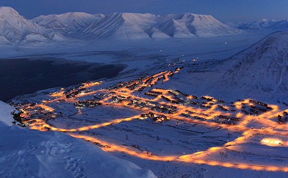
Longyearbyen occupies a small area of about 10
km² on the Nordenskiöld Land peninsula. It is nestled in the lower
reaches of the Longyear Valley (Longyeardalen), along the Longyear River
(Longyearbreen influences the area), on the southwestern shore of
Adventfjorden—a short 7-by-4 km branch of the larger Isfjorden, one of
Spitsbergen’s broadest inlets.
The town stretches along the valley
floor and fjord edge, with buildings climbing the lower slopes of
surrounding mountains. It is surrounded by steep, snow-capped peaks and
glaciers, creating a dramatic, enclosed setting.
Topography and
Landforms
Elevation: The town itself sits at low elevations near sea
level (minimum around -1 m at the fjord), but immediately rises into the
surrounding mountains. The broader topographic map of the Longyearbyen
area shows an average elevation of about 249 m, with peaks reaching over
1,000 m nearby (maximum in the immediate vicinity around 1,060 m).
Glaciers and steep slopes dominate the higher terrain.
Mountains:
Sharp, rugged peaks with exposed rock faces, scree slopes, and permanent
snow/ice fields. Prominent local features include mountains flanking the
Longyear Valley, such as those visible from Platåberget. The broader
Svalbard range includes peaks like Newtontoppen (1,713 m), the
archipelago’s highest.
Valley and River: The Longyear Valley provides
a relatively flat, habitable corridor. Glacial melt feeds the Longyear
River, which flows into Adventfjorden. The landscape shows classic
glacial features: U-shaped valleys, moraines, and alluvial plains.
Fjords and Coast: Adventfjorden offers a sheltered harbor area, but the
broader west coast of Spitsbergen is indented by numerous fjords. The
west coast benefits from the warming influence of ocean currents,
keeping parts more accessible.
Glaciers and Permafrost: Glaciers are
ubiquitous—Longyearbreen is a key local one. Over half of Svalbard is
glaciated. Permafrost is continuous and thick (typically 100+ m near
coasts, up to 500 m+ in highlands), with only the top ~1 meter thawing
in summer. This creates challenges like rock glaciers, solifluction, and
thawing-related instability (e.g., landslides).
The area features
Arctic desert-like conditions in places due to low precipitation (~200
mm/year in Longyearbyen), despite the fjord setting.
Climate and
Environmental Dynamics
Longyearbyen has a polar tundra climate
(Köppen ET), strongly moderated by the North Atlantic Current (a branch
of the Gulf Stream), making it milder than other places at similar
latitudes.
Temperatures: Winters are cold but not extreme (December
averages around -8°C to -14°C); summers cool (July highs 5–9°C, record
~21.7°C). Extreme variations occur.
Light Extremes: Polar night (sun
below horizon) from late October to mid-February (~110 days of
darkness/twilight); midnight sun from late April to late August (~123
days). Aurora borealis is visible in winter.
Precipitation and Winds:
Low annual precipitation qualifies parts as Arctic desert. Snow cover
persists 8–10 months. Weather is unpredictable with strong winds and
rapid changes.
Climate Change Impacts: Significant warming leads to
permafrost thaw, increased landslide risks, glacier retreat, and
infrastructure challenges (e.g., affecting buildings and the historic
cemetery).
Vegetation, Wildlife, and Human Adaptation
Vegetation is limited to tundra (mosses, lichens, dwarf shrubs like
crowberry). The inner fjord areas are relatively more fertile. Wildlife
includes polar bears (a constant consideration—rifles are required
outside town), Svalbard reindeer, Arctic foxes, and marine mammals.
Birds are abundant in summer.
The geography shapes daily life: no
roads connect to other settlements; transport relies on snowmobiles,
boats, planes, and helicopters. The airport is nearby, and the town is
built to withstand harsh conditions, with colorful buildings on stilts
or adapted foundations due to permafrost.
Early Exploration and Pre-Mining Era (1596–Early 1900s)
Dutch
explorer Willem Barentsz is credited with the first undisputed European
discovery of Svalbard in 1596 while seeking the Northeast Passage. He
named the main island Spitsbergen ("pointed mountains"). Earlier
mentions, such as in Icelandic sagas around 1194 referring to
"Svalbarði" (cold shores), may relate but remain unconfirmed.
For
centuries afterward, Svalbard (meaning "the land with the cold shores")
served as a no-man's-land (terra nullius). It attracted whalers
(1600s–1700s, primarily Dutch, British, and others), Russian Pomor
hunters and trappers (1700s–1800s), and later Norwegian overwintering
trappers (1800s–1900s). These activities involved hunting walrus, seals,
polar bears, and whales, leaving scattered remains like blubber ovens
and trapper cabins. Early tourism emerged in the late 1800s, with cruise
ships and a short-lived hotel at Hotelneset.
Founding of
Longyearbyen: The American Mining Era (1906–1916)
Coal discoveries in
the late 1800s/early 1900s shifted focus. In 1900, Trondheim
entrepreneurs claimed fields in Adventdalen. American businessman John
Munro Longyear (1850–1922), a timber and mineral developer from
Michigan, visited as a tourist in 1901. Impressed by coal prospects, he
and partner Frederick Ayer acquired claims and founded the Arctic Coal
Company (ACC) in 1906.
They established Longyear City (later
Longyearbyen) with Mine 1a ("Amerikanergruva"). The settlement included
barracks, docks, and infrastructure. Workers were mostly Norwegian and
Swedish, with American/British administration. Conditions were
primitive: crowded bunks, poor hygiene, monotonous food, and isolation.
An aerial tramway transported coal. Mine 2a opened in 1913. The
"American era" involved significant investment but faced labor unrest,
strikes, and financial challenges, especially during WWI.
Norwegian Takeover and Company Town Era (1916–1930s)
In 1916, ACC
sold operations to Norwegian interests, leading to the founding of Store
Norske Spitsbergen Kullkompani (SNSK). The settlement was renamed
Longyearbyen in 1926. Store Norske expanded infrastructure, building
barracks, a hospital, and even issuing its own currency (valid at par
with the Norwegian krone). A church and school opened in the early
1920s.
The 1920 Svalbard Treaty (effective 1925, now with 44+
parties) recognized Norwegian sovereignty while granting signatories
equal rights to economic activities (e.g., mining) and demilitarizing
the archipelago. This unique framework allowed continued international
involvement, notably by the Soviet Union.
Mining remained dominant,
but the town stayed a rugged company town with seasonal isolation (ships
couldn't reach it in winter). Families were rare; most workers left
families on the mainland.
World War II and Immediate Aftermath
(1939–1950s)
Svalbard's coal and strategic location drew attention.
In 1941, the population (~700–800 in Longyearbyen) was evacuated to
mainland Norway or Scotland. Germans established a weather station. In
1943, Allied and German forces clashed; battleships Tirpitz and
Scharnhorst bombarded settlements, destroying much of Longyearbyen (only
a few buildings like the hospital survived). Repopulation began in 1945.
Post-war reconstruction was rapid. Production recovered by 1948. New
housing (e.g., Nybyen barracks) appeared. The cemetery closed around
1950 due to permafrost preventing decomposition (bodies were sent
south). The community center Huset opened in 1951. Store Norske and
Soviet operations (e.g., in Barentsburg) dominated.
Modernization
and "Normalisation" (1960s–1990s)
The 1960s–1970s brought change
under active Norwegian policy to transform Longyearbyen into a
family-friendly community. Key developments:
Snowmobiles (1960s
onward).
Airport opened in 1975 (year-round access).
Television,
roads, schools, swimming pool, and more amenities.
Nationalization of
Store Norske (1976).
Shift from pure company town; Svalbard Council
(1971), later Longyearbyen Community Council (2002).
New mines
opened (e.g., Mine 3 in 1971, Mine 7 in 1972). Cars became more common
in the 1980s. Infrastructure improved dramatically with the undersea
fiber-optic cable (2004) and other modern links.
Contemporary
Era: From Coal to Tourism, Research, and Diversification (2000s–Present)
Coal mining declined due to economics, environmental concerns, and
policy. Mine 7 (last Norwegian mine near Longyearbyen) ceased operations
around 2025. The economy pivoted to tourism (tens of thousands of
visitors annually), research/education (UNIS – University Centre in
Svalbard, opened 1993), and services. The Svalbard Global Seed Vault
opened in 2008 nearby.
Today, Longyearbyen is a cosmopolitan, vibrant
hub with modern amenities, international residents, and strict
environmental/polar bear safety rules. It faces climate change
challenges (permafrost thaw, avalanches, etc.) but remains a gateway to
Arctic wilderness. Mining heritage (tramways, ruins) is preserved as
cultural landmarks.
Longyearbyen is a cosmopolitan microcosm, with residents from
nearly 53 countries, including significant Norwegian, Thai, Russian,
and Nordic populations. The average residency is seven years, driven
by job opportunities in tourism, research, or services. Despite its
isolation, the town feels vibrant, with a “normal” yet extraordinary
lifestyle shaped by its Arctic context.
Cultural Quirks and
Traditions:
Shoe Removal: A legacy of coal mining, residents and
visitors remove shoes when entering public buildings (hotels,
restaurants, churches, museums) to keep floors clean. Slippers are
often provided.
No Street Names: The town’s small size and simple
layout eliminate the need for street names, though buildings are
numbered.
Gun Culture: Firearms are common due to polar bear
risks, with gun safes at places like the grocery store.
No Births
or Burials: Pregnant women must travel to mainland Norway weeks
before giving birth due to limited medical facilities. Burials are
prohibited because permafrost preserves bodies, as seen with 1918
flu victims. A small graveyard exists, but no burials have occurred
in over 80 years.
Cat Ban: Cats are forbidden to protect local
wildlife, particularly birds.
Low Crime: Crime is nearly
non-existent, with minor incidents like bar brawls. A 2018 bank
robbery was a rare event, and the offender was quickly apprehended.
Community Life:
Longyearbyen has a young population, with 400
children attending preschool through high school. Schools, a
hospital, a library, a cinema, a sports center, and a university
(UNIS) create a surprisingly robust infrastructure. Social life
revolves around restaurants like Huset (known for its wine cellar
and Arctic cuisine) and events like the Dark Season Blues Festival
(late October), Longyearbyen Literature Festival (September), and
Taste Svalbard (October).
The Svalbard Church, a red wooden
structure built in 1958, serves as a community hub, hosting
Norwegian services, concerts, and social gatherings. It’s the
northernmost Lutheran church, with a Russian Orthodox chapel in
Barentsburg as its only rival.
Multiculturalism: The Svalbard
Treaty’s open residency policy attracts a diverse population.
English is widely spoken alongside Norwegian, and Russian is common
due to nearby Russian settlements like Barentsburg. The Thai
community is notable, running businesses like restaurants.
Longyearbyen’s economy has transitioned from coal mining to tourism
and research, with mining now a minor contributor.
Tourism: The
primary industry, driven by Svalbard’s Arctic wilderness, polar bears,
and unique phenomena like the Midnight Sun and Polar Night. Hotels,
restaurants, and tour operators (offering dog sledding, snowmobiling,
and boat trips) thrive, with summer (May–September) as the peak season.
Research: The University Centre in Svalbard (UNIS), established in 1993,
focuses on Arctic studies, attracting students and scientists. The
Svalbard Global Seed Vault, a critical biodiversity repository, and the
Svalbard Satellite Station enhance the town’s research profile.
Mining: Only Mine 7 remains operational, with uncertain prospects.
Historical mining relics dot the landscape, preserved as cultural
heritage.
Tax-Free Status: Svalbard’s duty-free status lowers prices
for alcohol, outdoor gear, and luxury goods compared to mainland Norway,
but food, especially fresh produce, is expensive due to shipping costs.
Residents pay a flat 16.2% tax rate.
The port, accessible only in
summer when pack ice recedes, supports tourism and freight, with weekly
boats to Tromsø and day trips to Barentsburg and Pyramiden.
Longyearbyen is a gateway to Arctic adventures, with activities
ranging from cultural exploration to wilderness expeditions. Most
attractions are in the walkable town center, but the surrounding
wilderness is the main draw.
Key Attractions:
Svalbard Museum:
Offers insights into Svalbard’s history, wildlife, and mining heritage,
with exhibits on polar bears and Arctic exploration.
North Pole
Expedition Museum: Chronicles early Arctic explorers from Norway,
Russia, and beyond, ideal for polar history enthusiasts.
Galleri
Svalbard: Displays Arctic art, maps, and cultural collections, including
works by Kåre Tveter.
Svalbard Church: A community landmark offering
scenic views and cultural events.
Svalbard Global Seed Vault: Perched
on a hill, this iconic facility is visible but not open to the public. A
visitor center for Arctic preservation storage is planned.
Camp
Barentz: A replica cabin honoring explorer Willem Barents, offering
historical meals and storytelling.
Outdoor Activities:
Dog
Sledding: Popular in winter with Svalbard Husky, offering scenic rides
through snowy valleys. Summer tours use wheeled sleds.
Snowmobiling:
A winter staple, with half-day to multi-day trips into the wilderness.
Snowmobiles are a common transport mode, with 883 registered in 1990
alongside 353 cars.
Hiking: Guided hikes to Plateau Mountain or
nearby glaciers ensure safety from polar bears.
Boat Tours: Summer
cruises to Tunabreen glacier, Barentsburg, or Pyramiden offer wildlife
sightings (polar bears, whales, walruses) and stunning fjord views.
Mine Tours: A 3-hour tour of Gruve 3 provides a glimpse into
Longyearbyen’s mining past, complete with helmets and headlamps (not
suitable for claustrophobics).
Ice Cave Exploration: Guided tours
explore caves beneath glaciers, offering a unique Arctic experience.
Wildlife Watching: Polar bears are best seen from May to August via boat
tours, with Arctic foxes, reindeer, and seabirds visible year-round.
Dining and Nightlife:
Huset: A historic restaurant with Arctic
dishes (reindeer, seal) and a renowned wine cellar.
Vinterhagen: A
conservatory restaurant with Arctic cuisine and views of the landscape.
Funktionærmessen: Offers high-end dining with international and
Arctic-inspired menus.
Svalbard Brewery: The world’s northernmost
brewery, serving craft beers.
Kroa: A cozy bar with pizza, burgers,
and live music, known as the northernmost bar.
Airport: Svalbard Airport Longyearbyen (LYR), the northernmost
airport with scheduled flights, offers daily services to Oslo (3 hours)
and Tromsø (90 minutes) via SAS and Norwegian. A shuttle bus connects
the airport to hotels.
Transport: No public transportation exists
except the airport shuttle. Walking is common in the town center, while
snowmobiles dominate in winter and cars in summer. Taxis are available
for deliveries and short trips.
Services: Longyearbyen has a
hospital, schools, a supermarket (Svalbardbutikken), outdoor shops, a
bank, and a cinema. Svalbard Samfunnsdrift manages infrastructure like
roads, water, and power.
Connectivity: Satellite communications
were introduced in 1978, and television broadcasts began in 1984. The
town is outside the Schengen Area, requiring identity checks for travel
to/from mainland Norway.