Location: Crimean peninsula Map
Eski-Kermen, also referred to in Crimean Tatar as Eski Kermen and in Ukrainian as Ескі-Кермен, stands as a remarkable medieval cave fortress and settlement, renowned as one of Crimea's most captivating archaeological landmarks. Nestled in the southwestern region of the Crimean Peninsula within the Bakhchisaray District—territory administered by Russia but internationally recognized as part of Ukraine—this site perches on a flat-topped mesa rising about 30 to 40 meters above the adjacent valley. It lies roughly 14 kilometers south of Bakhchisaray city and around 5 kilometers from the village of Krasny Mak (previously known as Zalesnoye). The name "Eski-Kermen," meaning "Old Fortress" in Crimean Tatar, is a relatively modern label; historical records suggest alternative names like "Kut" or "Kut-Eli," translating to "Gothic fortress" or "City of the Goths," hinting at possible Gothic inhabitants from the Taurian region. Spanning approximately 8.5 hectares, the elongated plateau measures over 1 kilometer in length and up to 200 meters in width. At its zenith during the 10th to 12th centuries, it likely housed between 2,000 and 3,000 residents, functioning as a bustling hub that integrated defensive fortifications, living spaces, and rock-hewn religious structures. In contemporary times, Eski-Kermen draws numerous visitors as a key stop on tours of Crimea's "cave cities," offering evocative ruins, intricate cave networks, and breathtaking vistas over the lush valleys below.
Established toward the close of the sixth century AD by the Byzantine
Empire, Eski-Kermen initially served as a strategic stronghold designed
to shield against nomadic incursions, such as those from the Göktürks,
and to oversee vital trade pathways through the Crimean highlands. It
began as a fortified outpost for Byzantine allies, potentially of Gothic
or Alan descent, leveraging the site's naturally impregnable cliffs for
defense. Some scholars speculate it could have been the fortress known
as Doros, given unique features like its advanced siege well. Through
the seventh and eighth centuries, it evolved into a key military
bastion, possibly falling under Khazar control during that period, which
diminished its frontline role but allowed it to persist as a settlement.
By the tenth century, it had transformed into a vibrant community
supporting crafts, farming, and commerce. Under the influence of the
Principality of Theodoro (also called Mangup) and later the Crimean
Khanate, it formed part of southwestern Crimea's defensive network.
The settlement reached its height in the tenth through twelfth
centuries, emerging as a regional agricultural powerhouse with extensive
viticulture (grape cultivation) and animal husbandry in the fertile
valleys nearby. It endured multiple assaults, including Khazar sieges in
the eighth century and Mongol-Tatar invasions in the thirteenth. Its
downfall accelerated at the end of the thirteenth century when, in 1299,
forces led by Nogai, a temnik (commander) of the Golden Horde, sacked
and torched the city. Although partial recovery occurred, a final
devastating blow came in 1399 from another Golden Horde army under
temnik Edigei, after which the site was abandoned. Survivors probably
relocated to neighboring areas like Chufut-Kale or Mangup-Kale.
Archaeological investigations kicked off in the nineteenth century, with
more rigorous digs in the 1920s and 1930s led by Soviet experts such as
N. Repnikov and A. Yakubovsky. Further excavations occurred in
1931–1933, 2015, and notably from 2018–2020, which uncovered the central
square and the western facade of a major structure in the city's core.
Today, it holds status as a federal cultural heritage site in Russia and
a national monument in Ukraine, with periodic research and preservation
efforts ongoing as part of the Bakhchysarai Historical and Cultural
Reserve.
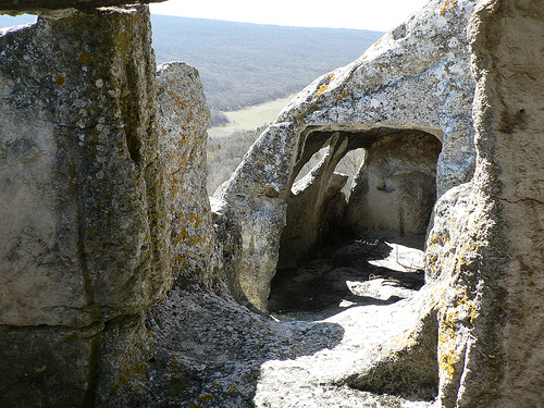
As a quintessential Crimean "cave city," Eski-Kermen blends
surface-level buildings with extensive subterranean excavations in the
soft limestone. The plateau's perimeter features sheer cliffs up to 30
meters high, with access primarily from the north via the main entrance.
The urban layout divided into rectangular blocks connected by
stone-paved streets 2–3 meters wide, some broad enough for wagons.
Defensive Structures: The primary gate consists of a rock-cut tunnel
equipped with arrow slits and a protruding barbican for added
protection. Encircling walls, up to 2 meters thick and constructed from
stone bound with lime mortar, fortified the site. Cliff-embedded
casemates served as battle stations for archers and siege engines,
complete with narrow embrasures. The southern sector included
watchtowers and additional cave-based defenses.
Residential and
Utility Caves: Over 350 artificial caves dot the interior of the city,
with about 50 more beyond its bounds, primarily dating to the 12th–13th
centuries and used for storage, workshops, stables, or livestock
pens—though around 15% had defensive or religious functions. Typical
dwellings featured one or two chambers with built-in niches for storage,
hearths for cooking, and ventilation shafts. Multi-level caves connected
by internal stairs were common.
Temples and Religious Sites: A
standout element is the remnants of a three-nave basilica from the
6th–8th centuries, measuring about 24 by 13 meters (expanded in the 11th
century), with surviving column bases and traces of frescoes. Adjacent
cave chapels include the "Temple of the Three Horsemen," adorned with
carved reliefs of saints George, Demetrius, and Theodore on horseback,
accompanied by Greek inscriptions. Another, the "Judgment Hall," is a
rock-hewn space with an altar and seating, possibly doubling as a venue
for assemblies or judicial proceedings. Evidence suggests a bishop's
residence near the central gates.
Infrastructure: A highlight is the
30-meter-deep siege well, a sophisticated engineering feat with an
84-step staircase divided into six flights and a 20-meter connecting
corridor—operational until the late seventh century and unparalleled
among Byzantine mountain defenses in Crimea. Additional facilities
included rainwater cisterns, grain silos, and wine presses. Excavations
have identified around 50 estates, each with courtyards merging stone
edifices and caves. The modern site resembles a maze of perforated
rocks, overgrown with flora, crisscrossed by visitor paths.
Panoramic Views: The elevated plateau affords spectacular overlooks
of the Kacha Valley, jagged mountains, and nearby hamlets, making it a
prime spot for photography, hiking, and serene reflection.
Archaeological Finds: Discoveries encompass Byzantine and Khazar-era
pottery, coins, weapons, and tools, many housed in museums in Simferopol
and Bakhchisaray. Recent digs (2018–2020) have revealed urban planning
elements like the central square, enhancing understanding of daily life.
Legends: Folklore links the caves to hidden treasures and guardian
spirits, while the "Temple of the Three Horsemen" is said to have warded
off invaders. Its ties to Gothic heritage add a layer of cultural
mystique.
Ecology: Integrated into a protected nature reserve, the
area boasts ancient woodlands of oak, hornbeam, and juniper, along with
endemic flora species, contributing to its appeal as an eco-historical
destination.
Accessing Eski-Kermen involves traveling from Bakhchisaray by bus or taxi to Krasny Mak (about 20 kilometers), followed by a 2–3 kilometer uphill hike on a maintained but steep trail—options include a western steeper path near parking or an eastern gentler route requiring more walking or a paid off-road transfer (around 1,500 rubles for a vehicle like a UAZ). Coordinates: 44°36'30"N 33°44'30"E. Organized tours from Simferopol or Sevastopol typically cost 1,000–2,000 rubles per person. The site operates year-round, though spring and autumn are ideal due to milder weather; summers can be scorching, and winters icy with slippery paths. As an open-air museum within the Bakhchysarai Reserve, entry fees (as of recent reviews) are approximately 300 rubles for adults, free for children under 14, with guided tours at 1,500–2,000 rubles—cash only, and some areas may be cordoned for ongoing excavations. Visits usually last 2–4 hours; prepare with sturdy footwear, water, sun protection, and a flashlight for exploring dim caves. Avoid rainy days for safety. Pair it with nearby sites like Chufut-Kale or Mangup (5–10 kilometers away) for a fuller "cave cities" experience. Eski-Kermen remains a vivid emblem of Crimea's layered medieval past, weaving together natural splendor, architectural ingenuity, and enigmatic history to enchant tourists, historians, and adventurers alike.