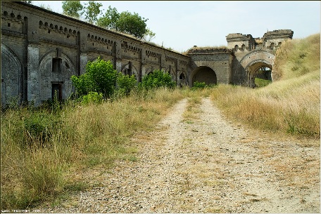
Location: Most of the people living nearby don't know about the fort and its secluded location so probably GPS is your best call. You can find fort's location here.
The construction of Fort Kerch started in 1857 shortly after Crimean war. General Totleben designed the fort in a way that it was impossible to see from the passing ships since according to peace treaty Russia was forced to stop military construction in the region. But due to indecisiveness of the conflict no one really kept a eye on a huge construction project.
The first fortifications on the coast of the Kerch Strait appeared in
1771. On the cape, called Pavlovsky, the first battery was located.
Subsequently, the fortification was repeatedly rebuilt and strengthened.
During the Crimean War, the battery was already armed with 20 guns.
One of the results of the Anglo-French and Turkish troops landing on May
12, 1855 at Kamysh-Burun, south of Kerch, was the need to surrender the
fortification, which was unable to resist the enemy from the land. Faced
with the threat of the capture of the fortress, the command ordered the
guns to be riveted, supplies to be destroyed, and the personnel to
retreat. A fortified camp of the French troops was set up on the
positions of the Pavlovsk battery and the surrounding area, where they
remained until June 1856.
Under the terms of the Paris Peace
Treaty, the Black Sea was declared neutral, and Russia was forbidden to
have a fleet and military ports here. The strengthening of the strait
did not contradict the terms of the agreement, therefore, already in
April 1856, instructions were given to send sapper units to Kerch to
study local conditions and survey the terrain. In August, sappers had
already begun work on the site of the former French camp. Initially, the
strengthening of the old Turkish fortress of Yenikale, located in the
depths of the Kerch Strait, was considered. But in December 1856, a new
project was initiated, according to which the fortifications were
located on the Pavlovsky Cape, which received the highest approval in
February. In addition, Alexander II ordered additional construction of
sea forts at the tip of the Tuzla Spit and on the reef of the Ak-Burun
cape.
Construction began in the same year. By the end of the
year, coastal batteries were roughed out, two barracks and a powder
magazine were erected, construction was also started in the strait from
the tip of the Tuzla Spit in the direction of Cape Pavlovsky. Colonel
Anton Antonovich, an experienced military engineer, supervised the work
on the spot. In October 1859, E. I. Totleben was appointed director of
the engineering department of the military ministry, who enjoyed the
full support of the tsar in the matter of strengthening Kerch and used
his rich experience in siege and defense of fortresses, primarily the
experience of defending Sevastopol. In 1860, earthworks began on the
Ak-Burun cape, the length of the stone barrier in the strait exceeded 3
km. In 1861 Emperor Alexander II visited the fortress for the first
time. After inspecting the construction, he ordered: “In honor of the
labors incurred by the soldiers: name the lunettes, the left Minsk, and
the right Vilna regiment. And the main fort will henceforth be called
Fort Totleben. After examining the work, the Sovereign congratulated
Colonel Nat on his promotion to major general.
In 1867, the Kerch
fortifications received the status of a fortress. When the tsar visited
the fortress for the third time in 1872, the work on the fortifications
was completed, and he was "quite pleased with the finishing of coastal
batteries."
The First World War on the Black Sea began on October
16, 1914 with an attack by ships of the German-Turkish fleet on Odessa,
Sevastopol, Feodosia, Novorossiysk. On this day, at about 6 o'clock in
the morning, the German light cruiser Breslau was discovered at the
entrance to the Kerch Strait, which set up a barrage of 60 mines - two
ships were blown up on it in a day. In connection with the threat of
attack, the Kerch fortifications were declared under martial law, in
accordance with the order of the commander of the fleet, they began
laying a defensive minefield - in Kerch, local ships were used for this.
Underground passages
Underground passages of Fort Kerch served the units stationed here as housing, storage and safe way to transport necessary ammunition. Huge underground towers had naval artillery, but it is long been commissioned and floors have collapsed although some stairs are still visible. Occasionally people do find military memorabilia like bullets, rifles parts and others. One of the grim findings you can discover here are human skeleton in the one towers. No one knows who it is and how this person got here. No one even knows when the person was killed here, but many legends circulate. According to one it is a skeleton of a German soldier who committed suicide here after he fell in love with a local girl and her father came between them. Others say it was a body of a political officer who was killed by his own father for joining the Commies. Aside retelling of famous plots of "Romeo and Joliet" and "Taras Bulba" none of the legends provide credible evidence on the identity of the body.
During the USSR
In Soviet times, military warehouses with property and ammunition of
the Black Sea Fleet were located on the territory of the fortress. The
disciplinary battalion of the Black Sea Fleet was also located here.
In the mid-1970s, thousands of cubic meters of silt, taken out
during the dredging of the Genoese harbor, containing objects dating
back to the 5th century BC, were dumped in shallow water near the Mine
Pier of the fortress.
Modernity
After the collapse of the USSR, the reduction of military units
began, and in 2003 the territory of the fortress was transferred to the
Kerch State Historical and Cultural Reserve.
The fortress is a
landmark of Kerch and Crimea and is protected by the state as a unique
monument of fortification construction of the 19th century. Tourist
excursions are conducted on its territory. Some dungeons are still
little explored.
In August 2019, during demining work, an
ammunition depot was discovered in the fortress. In the warehouse during
the Great Patriotic War there were 1,700 fragmentation bombs weighing
2.5 kilograms each, as well as one 100-kilogram high-explosive bomb.
Strategic Design and Overall Layout
The fortress was built to
guard the entrance to the Sea of Azov and protect Russia's southern
borders after the Crimean War and the Treaty of Paris (1856), which
restricted naval forces but permitted strait fortifications. It occupies
a large area (around 400–420 hectares) with a perimeter of about 7 km
(including ~4 km of coastline). It could house a garrison of up to 5,200
men and featured over 300 structures.
Key Components: Central
Fort Totleben (on the highest point, ~110 m above sea level), flanking
Vilensky (Vilna) and Minsk lunets (lunettes), coastal batteries,
caponiers, demi-caponiers, a deep ditch, and extensive earth ramparts.
"Invisible" Fortress: A hallmark is its low-profile design. Unlike
traditional high-walled castles with visible towers and crenellations,
much of it is integrated into the terrain or subterranean. From sea or
land, it blends into the landscape, making it hard for enemies to spot
or target effectively. This "fortress-in-reverse" or camouflaged
approach relies on natural contours, earth cover, and strategic
placement.
Materials: Primarily stone masonry for durable structures
(casemates, barracks, powder magazines), combined with massive
earthworks for ramparts and glacis. The design drew on lessons from
Sevastopol, emphasizing bomb-proof shelters and counter-siege
capabilities.
Defensive Architecture and Key Features
The
layout follows contemporary bastion/trace italienne principles adapted
for coastal artillery, with polygonal elements and heavy emphasis on
enfilading fire and underground defense.
Ramparts, Ditches, and
Earthworks: A wide, deep defensive ditch (up to 5 m) encircles parts of
the complex, backed by high earthen ramparts. These absorbed artillery
impacts. Coastal batteries commanded the strait.
Caponiers and
Demi-Caponiers: Prominent structures like Caponier No. 6 and No. 7
(grand, vaulted brick or stone enclosures) allowed flanking fire along
the ditch. These are among the most impressive surviving elements, with
thick walls and gun ports for enfilade defense.
Lunettes and
Redoubts: The Minsk and Vilensky lunettes provided advanced positions
with their own barracks, gun emplacements, and protective features. A
covered way (chemin couvert) and reduit offered additional layers.
Artillery Positions: Originally armed with hundreds of guns (over 430
long-range pieces and ~48 mortars with ~12 km range). Gun courtyards,
mortar batteries, and coastal positions featured traversing platforms
and protected embrasures. Firepower allowed a simultaneous broadside of
up to 20 tons of projectiles.
Barracks and Service Buildings: Sturdy
stone barracks (e.g., in the lunettes, sometimes called "French
barracks" from earlier occupation) housed troops. Powder magazines (5
main ones) were heavily protected, with capacity for ~20,000 poods (~320
tons) of powder. There were also workshops, cisterns, and supply
facilities.
Subterranean Architecture (the Most Remarkable
Aspect)
A defining feature is the extensive underground network,
designed for protection against bombardment, troop movement, storage,
and counter-mining.
Casemates and Galleries: Bomb-proof vaulted
chambers and long enfilade galleries connected positions. These served
as living quarters, ammunition storage, and fighting positions.
Countermine Galleries and Tunnels: Intricate systems of listening
passages (to detect enemy mining), counter-mine galleries, and
communication tunnels. These allowed defenders to preempt or explode
enemy tunnels. Some remain unexplored or partially cleared.
Lost or
Restricted Areas: Deep dungeons, powder cellars, and labyrinthine
passages. Many are cool, dark, and require caution (flashlights
recommended for visits). Legends and inscriptions from soldiers (dating
to the 1860s) survive on walls.
The underground emphasis made it
highly resilient, as seen in WWII fighting where it served as a
strongpoint despite limited surface visibility.
Historical
Adaptations and Condition
Later additions included Soviet-era coastal
batteries (e.g., BS-48, BS-9) and anti-aircraft positions. It saw action
in WWII (1941–1942), serving as a warehouse, strongpoint, and site of
fierce combat before being used post-war as a naval arsenal and
disciplinary battalion site.
Today, it is partly ruined but in
relatively good condition for its age, preserved as a museum-reserve
with guided tours (pedestrian and vehicle routes covering key features
like caponiers, batteries, and viewpoints). Access is restricted for
safety (unexploded ordnance, unstable areas); solo visits are not
permitted. It offers panoramic views of the strait and Kerch, including
the Crimean Bridge.