Location: Krasnoyarsk Krai Map
Area: 1 773 300 ha
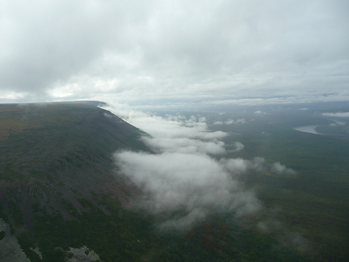
Putorana Plateau (Плато Путорана) covers an enormous area of 1 773 300 ha in Krasnoyarsk Krai in Russia. The highest peak on the Putorana Plateau is Mount Kamen ("rock" in Russia) that reaches a height of 1700 meters (5,600 ft). Putorana Plateau is a basalt plateau on the North- West edge of the Central Siberia. It is named after a Putorana Lake in its center. Local Evenki tribe gave the lake its name and can be translated as "smoky" or "cloudy" since it is commonly covered by a fog. Although another local tribe of Yukagirs claim that name as their own and believe it comes from a name that can be translated as the "Mountain without tops". Whatever the entomology of the name might be one is certain, all indigenous inhabitants of these lands considered Putorana Plateau as sacred ground inhabited by a God of Fire. Beautiful legend was probably formed during early human explorers who remembered the time when Putorana Plateau saw active volcanic activity or showed signs of past eruptions on the surface. Ancient shamans came here to pray, meditate, perform elaborate religious ceremonies and leave offerings to the gods. Majority of people were not allowed here.
Best Time to Visit
Summer (late May/early June to early
September): The main season. Temperatures average around +10–16°C
(50–61°F) during the day, with cool nights near freezing. Expect
variable weather—sun, rain, wind, or even brief snow.
Peak
recommendations: Late June to early July for midnight sun (nearly
24-hour daylight) and before mosquitoes peak. August offers good hiking
with fewer bugs but shorter days.
Avoid winter/off-season unless
experienced with extreme cold (down to -40°C) and specialized
gear—access is very limited.
How to Get There
Gateway: Fly to
Norilsk (from Moscow or other major Russian cities). Norilsk is a closed
industrial city ~180–200 km from the plateau.
Access: No roads.
Common options include:
Boat/hovercraft along lakes (e.g., Lake Lama,
5–6+ hours from Norilsk).
Helicopter (expensive but scenic for
panoramas or drop-offs).
Snowmobile in winter.
Most visitors
join organized tours (highly recommended for logistics, safety, and
permits). Independent travel is challenging and not advised for
first-timers.
Permits and Regulations
The core area is part of
Putorana Nature Reserve (Taimyr Reserves). You need a permit—apply in
advance via the official reserve website (zapovedsever.ru) or through
your tour operator.
A guide is often required or strongly advised.
What to Do
Trekking/hiking: Multi-day routes (e.g., 100–150 km
over 7–12 days) across tundra, canyons, and plateaus. Moderate to
strenuous with steep ascents, river crossings, and rocky terrain.
Waterfalls and lakes: See Talnikovy (seasonal, one of Asia's highest),
Kandinsky, and fjord-like lakes.
Other activities: Fishing (Arctic
char, etc.), wildlife spotting (reindeer migration, snow sheep, bears),
northern lights (better in shoulder seasons), boat trips, or helicopter
flights.
Base camps (e.g., on Lake Lama) offer basic lodging for day
hikes.
Essential Packing List
Waterproof trekking boots +
rubber/gumboots for wet terrain.
Layered clothing: Thermal underwear,
fleece, wind/waterproof jacket, warm down jacket, hat, gloves.
Mosquito net/head net + strong repellent (bugs can be intense in
summer).
Backpack (40–50L), rain gear, personal first aid kit,
headlamp, binoculars.
Sunglasses, sunscreen (Arctic sun), fishing
gear if interested.
Visiting Tips and Safety
Physical fitness:
Routes involve uphill climbs and uneven ground. Assess your health and
experience level.
Weather: Changes rapidly—always carry layers and
rain protection. Be prepared for wind and precipitation.
Wildlife:
Respect bears, reindeer, etc. Store food properly; maintain distance.
Isolation: No mobile signal in most areas. Tours provide satellite comms
or radios.
Costs: Expect high expenses due to remoteness (flights,
boats/helicopters, tours). Package tours range from several hundred
thousand RUB upward.
Environmental respect: Follow Leave No Trace
principles—this is a fragile, protected ecosystem.
Health: Bring
medications; purify water. Norilsk has some services before heading out.
Join a reputable tour operator (e.g., those offering boat access to
bases like Bunisyak) for comfort, safety, and local knowledge.
Location and Extent
The plateau lies east of the Yenisei River
valley, roughly between 67° and 70° N latitude (about 100 km north of
the Arctic Circle). It is bounded to the north by the North Siberian
Lowland, to the south by the Syverma and Tunguska plateaus, and to the
southwest by the Anabar Plateau. Its central coordinates are
approximately 69°2′49″N 94°9′29″E, with the nearest major settlement
being Norilsk (about 200 km northwest, though access to the plateau
itself is extremely limited—no roads penetrate the core, and it is
reachable only by helicopter or boat).
The full Putorana massif spans
roughly 800 km in length and 500 km in width, covering an area often
estimated at around 250,000 km² (comparable in scale to a large European
country). However, the UNESCO World Heritage Site (inscribed in 2010)
focuses on the pristine central portion within the Putoransky State
Nature Reserve, encompassing 1,887,251 hectares (about 18,872 km²), plus
a 1,773,300 ha buffer zone. This protected core preserves the most
spectacular and undisturbed landscapes.
Russia’s official geographic
center is located on the southern edge of the plateau, at Lake Vivi
(66°25′ N, 94°15′ E).
Geological Origins
The plateau
originated from one of Earth’s largest volcanic events: massive plume
volcanism associated with the Siberian Traps around 250 million years
ago (Permian-Triassic boundary). A huge upwelling of magma from deep
within the Earth erupted through fissures, blanketing the region with
successive layers of basalt lava flows up to 3,000 m (10,000 ft) thick
in places, though the central plateau retains about 1,500 m of layered
basalts, tuffs, and sedimentary interbeds.
Over millions of years,
tectonic uplift, glacial action, and river erosion dissected this
ancient lava plateau into its current form. The result is classic
trappean (stepped) relief—alternating layers of hard, erosion-resistant
basalt/dolerite and softer tuffs/sandstones create distinctive
“staircase” slopes and flat-topped mesas. Glaciation during the
Pleistocene further sculpted deep canyons (up to 1,500 m deep) and
fjord-like valleys.
Topography and Relief Features
The
Putorana is a high-lying, dome-shaped highland with an average elevation
of 800–1,200 m. It features numerous flat-topped mountain massifs (table
mountains) separated by deep, wide canyons and gorges. The highest peak
is Mount Kamen (also called Gory Putorana’s summit) at approximately
1,678–1,701 m (5,505–5,581 ft), the tallest point on the entire Central
Siberian Plateau.
Key subranges include the Keta Range, Lontokoisky
Kamen, Kharayelakh Range, Chaya-Ayan, Brus Kamen, and Lama Range. The
terrain is characterized by:
Steep, stepped scarps (300–800 m high)
along much of its perimeter.
Deeply incised valleys with pronounced
“ladder-like” walls visible in outcrops (up to 40 distinct lava layers).
A rugged, markedly eroded landscape that stands out sharply against the
surrounding lower plateaus.
Higher elevations support mountain
tundra, while sheltered valleys and lower slopes transition into sparse
forest. The overall relief creates an otherworldly, fortress-like
appearance with dramatic vertical drops and expansive flat summits.
Hydrological Systems
The plateau is a major watershed of northern
Eurasia, with high precipitation and permafrost supporting an
extraordinary network of water bodies. It features:
More than
25,000 lakes, many of which are long, narrow, and fjord-like due to
glacial and tectonic carving. These reach depths of 180–420 m and
lengths up to 100–150 km. Major examples include Lakes Lama, Keta,
Dyupkun, Glubokoye, Khantayskoye, and Ayan. Collectively, they form the
second-largest freshwater reservoir in Russia by volume after Lake
Baikal.
Countless rivers and creeks that carve deep canyons, creating
thousands of waterfalls. Notable ones reach heights of 108 m (e.g., in
the Kanda River valley, one of Russia’s tallest).
Pristine cold-water
systems fed by snowmelt and rain, with strong seasonal flows.
These features produce some of the most visually striking landscapes in
the Arctic: mirror-like lakes nestled between sheer basalt cliffs,
cascading waterfalls tumbling over stepped ledges, and braided rivers
winding through canyons.
Climate
Lying north of the Arctic
Circle, the Putorana experiences a harsh subarctic climate that is
sharply continental. Winters are long and severely cold (January
averages around –27.5°C, with extremes to –40°C or lower), while summers
are short and cool (July averages +8–14°C, with occasional maxima near
+16°C). Precipitation totals 500–800 mm annually (higher at elevation,
up to 1,200–1,600 mm in some western areas), falling mostly as summer
rain, with relatively sparse but long-lasting snow cover (200–300 days).
Permafrost underlies most of the plateau. In the center, polar day lasts
about 53 days (late May to mid-July) and polar night about 31 days
(early December to early January). Microclimates vary: lake valleys can
be milder due to sheltering from northerly winds, while exposed summits
are windswept and tundra-dominated.
This combination of extreme
latitude, elevation, and relief produces a striking ecological
gradient—from northern taiga forests in valleys to tundra and even
arctic desert on the highest plateaus—making the Putorana a textbook
example of Arctic landscape diversity and processes.
The Putorana Plateau (also known as the Putorana Mountains or
Putorana Plato in Russian) is a vast, isolated basaltic highland in
the northern part of Central Siberia, Russia, within Krasnoyarsk
Krai. It lies roughly 100 km north of the Arctic Circle, east of the
Yenisei River, and southwest of the Taimyr Peninsula, forming the
northwestern edge of the Central Siberian Plateau. The plateau spans
approximately 500 km in length and up to 250–500 km in width (with
the full massif covering around 250,000–500,000 km² depending on
definitions), rising to a maximum elevation of 1,701 m at Mount
Kamen. Its dramatic landscape—characterized by flat-topped
"trappean" (stepped) mountains, deep canyons, over 25,000 lakes
(many fjord-like and up to 420 m deep), thousands of waterfalls, and
pristine subarctic ecosystems—makes it one of the most remote and
untouched wilderness areas on Earth.
Geological History:
Formation of the Siberian Traps (~250 Million Years Ago)
The
plateau's origins trace back to one of the most cataclysmic volcanic
events in Earth's history during the late Permian to early Triassic
period, around 250–252 million years ago. It is a remnant of the
Siberian Traps, a massive flood basalt province formed by plume
volcanism. A huge mantle plume (a column of hot magma rising from
deep within the Earth, possibly from the core-mantle boundary)
caused enormous eruptions through fissures rather than central
volcanoes.
Over tens of thousands of years (estimates range from
60,000+ years of sustained activity), billions of cubic kilometers
of basaltic lava, tuff, ash, and gases poured out, creating layered
deposits up to 1.5–3 km thick in places (with up to 40 distinct
layers visible in outcrops). The Putorana area represents the
northernmost and thickest preserved section of these traps on the
northern flank of the Tunguska Syneclise (a large sedimentary basin
overlying Precambrian basement). Underlying Paleozoic sedimentary
rocks (sandstone, claystone, and coal-bearing strata) were capped by
alternating basalt flows, dolerite sills/dykes, and tuffs.
This
event is widely linked to the Permian-Triassic mass extinction (the
"Great Dying"), the largest in Earth's history. The eruptions
released vast quantities of greenhouse gases (CO₂, methane), sulfur
aerosols, and toxins, triggering global warming, ocean
acidification, anoxia, and climate disruption. Estimates suggest it
wiped out ~96% of marine species, 70–73% of terrestrial vertebrates,
and caused major insect extinctions.
Post-Formation
Evolution: Uplift, Erosion, and Glaciation (Triassic to Present)
After the volcanic phase, the region underwent long-term tectonic
uplift, beginning significantly in the Neogene-Quaternary (~30
million years ago onward) and continuing today at rates of ~11
mm/year. This created a dome-shaped basalt highland (the highest
part of the Central Siberian Plateau), with differential erosion of
the layered rocks producing the classic "trappean" stepped
relief—flat summits and terraced slopes resembling giant staircases.
Tectonic faulting and river incision deepened canyons (up to 1,500
m), while repeated Pleistocene glaciations (especially during the
Zyryan and Sartan stages) carved U-shaped valleys, fjord-like lake
basins, and moraines. Around 10,000 years ago, tectonic movements
redirected ancient river systems (e.g., paleo-rivers that once
flowed south), forming the modern network of deep, narrow lakes
(e.g., Lama, Keta, Glubokoye, Khantayskoye) and high-density
waterfalls (including some of Russia's tallest cascades). The
landscape continues to evolve slowly through fluvial erosion,
permafrost processes, and minor modern glaciation (only ~22 small
glaciers remain).
This combination of ancient volcanism, uplift,
and Quaternary glaciation produced a unique subarctic "island" of
biodiversity at the taiga-tundra transition, with unusually high
plant diversity for its latitude due to its position at the junction
of western and eastern Siberian floras.
Indigenous Peoples
and Cultural Significance (Millennia to 20th Century)
For
thousands of years, the plateau was inhabited (or at least
seasonally used) by indigenous groups, primarily the Evenki
(Evenks), Dolgan, and to a lesser extent Nganasan peoples. They
practiced nomadic reindeer herding, hunting (especially the endemic
Putorana snow sheep, Ovis nivicola borealis, isolated ~15,000 years
ago), fishing, and gathering. The Evenki name "Putorana" (or
variants) is often translated as "country of lakes with steep
banks," "smoking mountains," or "mountains without peaks." Local
legends portrayed it as a sacred or spiritual realm—home to spirits,
the god of fire, or underworld forces—leading to shamanic practices
and avoidance of certain areas. Evenk wooden idols (soul-keepers
carved from larch) and other ethnographic traces (reindeer corrals,
sable traps, cult sites) have been found, though human impact
remained minimal due to the harsh climate and remoteness.
By the
Soviet era, collectivization and state reindeer farms disrupted
traditional life. Domestic herding occurred in peripheral areas
until the mid-1970s, but the last indigenous residents left the
central plateau around 1982, relocating to settlements or state
collectives. Small indigenous communities (e.g., ~400 Dolgan/Evenk
in Khantaisky village on Lake Khantayskoye in the buffer zone)
continue traditional practices outside the strict reserve core
today.
European/Russian Exploration and Scientific Discovery
(19th–20th Centuries)
Systematic knowledge of the plateau came
with Russian scientific expeditions. The pioneering figure was
Alexander von Middendorff (1815–1894), a Baltic German naturalist in
Russian service. During his 1843–1845 Siberian expedition (part of
the Imperial Russian Geographical Society efforts), he crossed the
Taimyr Peninsula and provided the first scientific descriptions of
the region's northern reaches, including observations on
permafrost's effects on flora, fauna, and landscapes. He documented
spurs of the plateau and laid foundational geographic insights.
Further Academy of Sciences expeditions followed in the late 19th
and early 20th centuries. In 1921, Soviet geologist Nikolay
Urvantsev (famous for Norilsk discoveries) conducted a geological
survey, heard the Evenk name, and formally placed "Putorana" on maps
while exploring for minerals. His work helped map the plateau's
resources (basalt, ores) and supported later industrialization
nearby (e.g., Norilsk nickel deposits, though outside the plateau
proper). Soviet-era helicopter-accessed studies by geologists,
biologists, and hydrologists intensified in the mid-20th century,
focusing on volcanism, lakes, and wildlife.
Modern Protection
and Conservation (Late 20th–21st Centuries)
The plateau's
remoteness (no roads; access only by helicopter or boat) preserved
its pristine state. In 1987 (formally 1988), the Putoransky State
Nature Reserve (Zapovednik) was established by decree of the
Krasnoyarsk Krai authorities, covering 1,887,251 ha (core) plus a
1,773,300 ha buffer zone. It was created primarily to safeguard the
world's largest wild reindeer herd (part of the Taimyr population's
migration route) and the rare Putorana snow sheep.
In July 2010,
the reserve was inscribed as a UNESCO World Heritage Site (reference
1234) under natural criteria (vii) for its superlative scenic beauty
(layered basalt traps, canyons, waterfalls, lakes) and (ix) for
ongoing ecological processes in a complete set of subarctic/arctic
ecosystems (taiga to arctic desert). It is strictly protected—no
resource extraction, minimal tourism, and only scientific/monitoring
activities allowed inside the core. The combination of legal
safeguards, isolation, and harsh climate ensures minimal human
influence.
Today, the plateau remains a living laboratory for
studying climate change impacts on Arctic systems, with only a
handful of wardens and rotating researchers. Nearby Norilsk (a major
industrial center) highlights the contrast: the plateau is one of
Siberia's last true wildernesses amid broader regional environmental
pressures.