Location: Khabarovsk Krai Map
Sikhote- Alin (Сихотэ́-Али́нь)
is an extensive mountain range that extends from the Khabarovsk
Krai to Primorye Oblast in the Russian Far East. Parts of the
area is under federal protection. Sikhote- Alin is composed of
volcanic field in the Mesozoic folding of the Pacific Rim. It's
total length is about 1200 km, width of 250 km and maximum height of
2090 meters at the Mount Jani- Tordoki. Other high peaks include Ko
(2003 m), Thou, Jani (1955 m), Annick (1933 m) and many others. The
vegetation of the region ranges from coniferous taiga to tundra at
the highest points.
Sikhote- Alin Biosphere Reserve protects
part of the mountain range. Due to its untounched nature it is
designated as the UNESCO World Heritage List. The best time to visit
Sikhote Alin is between April and November when temperatures allow
unhindered travel through the region.
Sikhote Alin is
inhabited by endemic Far Eastern leopard and Siberian tiger, the
largest specie of the cat family. Needless to say these huge cats is
a dangerous animal that can easily kill any man of any size.
Venturing into this virgin forests without any time of firearms is
foolish at best. Local tigers are known for hunting man as well as
other game. The climate in the region is fairly mild due to cyclones
that hit the region from the South East. Snow cover usually lasts
from November to March. The highest danger from avalanches in the
region usually lasts from January till March.
The most
popular hiking trails include:
Mis Severny (North Cape) lasts for
about 3 hours
Ozero Blagodatnoye (Lake Peaceful) lasts for about
3 hours
Kluch Kabany (Boar Spring) lasts for 7 hours
Nature trails are also equipped with observation towers, observation
decks and wood pathways through the wetlands.
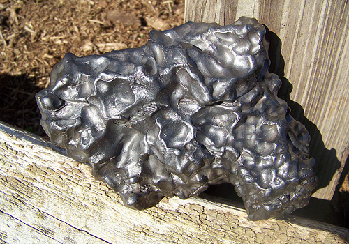
Meteorites
According to one version, Sikhote-Alin is translated from the Manchu language as "coastal ridge". According to another version, Sikhote-Alin can be translated from Nanai as "spruce mountains". The stem "alin" is found in the toponymy of the region: Dusse-Alin and Yam-Alin.
As a rule, the highest peaks of the Sikhote-Alin have
a sharply defined contour and are covered with large stone placers in
vast areas. The relief forms resemble heavily destroyed cirques and
cirques of mountain glaciation - two pronounced such formations of
regular round shape are located 7 km south of the village of
Innokentievskiy (diameter 12.5 km) and 6 km west of the village of
Vanino (diameter 8 km).
They are composed of sandy-shale deposits
with numerous breakthroughs of intrusions, which led to the presence of
deposits of gold, tin and polymetals. In tectonic depressions within the
Sikhote-Alin deposits of hard and brown coal.
In the foothills,
basalt plateaus are common. For example, the rather large Sovgavan
Plateau is stretched approximately 70 kilometers northwest of the city
of Sovetskaya Gavan (Soviet Gavan Plateau is an area consisting mainly
of large hills with very gentle slopes and flat-topped mountains, with a
gradual rise in relief from the sea level cut (approx. 300 meters) up to
800-900 meters, which is much higher than the lower tier of clouds).
Plateau areas are also found on the main watershed. The largest is the
Zevinsky plateau, on the watershed of the upper reaches of the Bikin and
the rivers flowing into the Tatar Strait. In the south and east, the
Sikhote-Alin is represented by steeply sloping mid-mountain ranges, in
the west by numerous longitudinal valleys and basins, and at altitudes
of more than 900 m - bald mountains.
In general, the Sikhote-Alin
has an asymmetric transverse profile. The western macroslope is more
gentle than the eastern one. Accordingly, the rivers flowing to the west
are longer.
There are no areas with a high degree of avalanche
danger on the territory of the Sikhote-Alin. Most of it is occupied by
areas with a low degree of avalanche danger. Only the upper reaches of
the Bikin, Khor, Anyui, Koppi and Samarga rivers are classified as areas
with an average avalanche danger.
The Sikhote-Alin mountain
system is seismically dangerous.
In the cross section of the Sikhote-Alin mountain
range, up to eight ridges of different directions are distinguished.
The western section is represented by three meridional ridges (Blue,
Eastern Blue and Cold).
The southern part of the Sikhote-Alin (in
Primorye) south of the Przhevalsky mountains is represented to a large
extent by wooded mountain peaks of a rounded or simply regular shape.
The Shkotovskoe plateau stands out here.
The northern
Sikhote-Alin differs significantly in landscape and is a highly rugged
mountainous terrain with taiga vegetation, heaps of rocks and deep
ravines in which rivers or streams flow.
The vegetation of Sikhote-Alin is diverse: the
southern and central part of this mountainous country up to an altitude
of about 500 m is covered with coniferous-broad-leaved forests with a
predominance of Manchurian species of vegetation, in the northern part -
coniferous forests of Ayan spruce and white fir. Mountain tundra is
noted at high altitudes. In the lowlands of the mountains, grass can
reach a height of 3.5 m, and it grows in a continuous carpet.
In
the foothills of the Sikhote-Alin, an endemic animal lives - the Far
Eastern leopard. Other mountain endemics are coniferous microbiota and
Olginskaya larch.
In the last few decades, foresters have noted
the drying up of the fir-spruce forests of the Sikhote-Alin (Man'ko,
2003). There are several reasons for this: damage to trees by viral
diseases, changes in the groundwater regime. Nevertheless, the main
cause of this phenomenon should be considered global climate change.
Diseases are already a consequence of the weakening of trees, the
inconsistency of their genetic program with environmental conditions
that have changed as a result of global climate change. As the Ayan
spruce falls, the Korean cedar and some broad-leaved species become more
active. In short, a climatogenic succession of vegetation occurs in
Sikhote-Alin.
The climate on the eastern slopes is quite mild and
snowy, which is determined by the frequent intrusions of cyclones from
the Sea of Japan, while on the western slopes it is sharper continental
and has little snow. The average daily temperatures in January are -8°C
in the southeast to -15...-22°C in the central and northern regions. In
the mountains of the central and northern Sikhote-Alin, however,
nighttime temperatures can drop below -45 degrees.
Snow in the
southern regions lies within 4-5 months, from December to April, and in
the northern regions - from the beginning of October to the end of May
inclusive, that is, about eight months. The distribution of
precipitation during the winter of the period is uneven - the maximum
heights of snow cover are observed in March. During the winter period,
heavy snowfalls, intense snowstorms and deep thaws are observed on the
entire eastern macroslope (coast). The amount of precipitation per year
is high (up to 800-1000 mm), but most of it falls in the spring and
summer.
In general, the climate is quite difficult for humans -
almost the entire territory of Sikhote-Alin, except for the southern
regions of Primorye, is officially classified as an area with adverse
climatic conditions and equated to the Far North.
The duration of
the avalanche period is up to 90 days, with the peak of avalanche
activity in January-March, depending on the nature of precipitation
during the cold period. Avalanches are small. In most of the
avalanche-prone area, there are avalanches with a volume of less than 10
thousand m³, and only some of them in the ridge areas of the central
part of Sikhote-Alin can reach 30-50 thousand m³.
In the floodplains of the Sikhote-Alin rivers,
archaeologists have discovered sites of an ancient man of the Neolithic
era (V-III centuries BC). The villages were located on terraces 4-6 m
high. Experts called this ancient culture of the southern part of
Primorye Zaisanovskaya. Interestingly, many of the artifacts discovered
by scientists are made of obsidian: knife-like plates, piercings,
scrapers, double-sided processed arrowheads, triangular bevelled knives,
slate knives and tips.
During excavations on one of the plateaus
of the Sikhote-Alin, archaeologists discovered the skeleton of a huge
stone structure. The layout of the building indicates that the object
belongs to the Bohai period (VI-IX centuries). The nature of the finds
allows us to conclude that this is the palace of the Bohai Kingdom,
which existed on the territory of Manchuria, Primorsky Krai and the
northern part of the Korean Peninsula more than 1000 years ago. In the
mountains of Sikhote-Alin, the remains of buildings of this ancient
culture have already been found: a signal tower, a castle and several
fortifications, which are credited with not only protective, but also
religious functions.
Like all mountainous territories, the
Sikhote-Alin began to be developed by man along the valleys of large
rivers, primarily along the Amur and Ussuri; along the fertile plains of
the lower reaches of medium-sized rivers, such as Anyui, Khor, Bikin,
Ussurka (Iman). The first centers of civilization also arose near
convenient sea harbors in the mouth parts of the rivers of the sea
basin. The active advance of civilization on the upper reaches of the
rivers in this region began with the appearance of the first mines in
the middle of the 20th century. After the collapse of the USSR, mass,
uncontrolled poaching deforestation of the deep Sukhote-Alin began. In a
relatively short period of active deforestation, the ecological balance
in the region has been fundamentally shaken.
Also, the forests of
the Sikhote-Alin suffer from numerous annual fires - sometimes huge
areas of the taiga burn out, and spruce and larch deadwood is typical
for many tens of kilometers, which is gradually overgrown with deciduous
trees (secondary forest).
The largest forest fire in terms of
area occurred in October 1976 in the Khabarovsk Territory. The scale of
the disaster was so great that a government commission chaired by A. N.
Kosygin was urgently created in Moscow, and an emergency headquarters
under the regional executive committee worked in Khabarovsk. In
different places, the fire engulfed dozens of taiga villages, a number
of enterprises in the forestry and woodworking industries, ammunition
depots were torn. Massive burning of the taiga caused heavy winds up to
40 m/s, which brought down centuries-old trees and tore roofs off
multi-storey buildings. The fire element lasted 14 days, according to
the most rough estimates, about 400 million cubic meters of wood burned
out. Also, the settlements of the Khabarovsk Territory suffered to
varying degrees, there were human casualties. The consequences of this
fire are still perfectly visible, after 40 years.
The mountainous
regions of the Sikhote-Alin remain almost uninhabited by humans. Most of
the cities and large settlements are located in the foothills in the
Southern Primorye, as the most favorable area for life - along the
valleys of the Ussuri and Amur rivers and along the coast of the Sea of
Japan. In the central and northern parts, there are small settlements
along the only railway laid here.
In 1943-1945. A single-track
railway was laid through Sikhote-Alin from Komsomolsk-on-Amur to the
port of Vanino and the city of Sovetskaya Gavan with a length of 445 km.
A railway tunnel with a total length of 413 meters was pierced at the
Kuznetsovsky Pass. In 2011, in order to increase the capacity of the
railway, a new tunnel 3890 m long was punched. Active reconstruction of
the railway tracks is currently underway.
By the autumn of 2017,
a section of the road was laid through the Sikhote-Alin (old number -
P454) from the port of Vanino to the village. Lidoga, with access to the
road from Khabarovsk to Komsomolsk-on-Amur, with a total length of 319
km. The road surface is asphalt. The road crosses the mountains along
the 49th parallel.
In the 1900s and 1920s Sikhote-Alin was the object of
several expeditions of V.K. Arsenyev: in 1906, in 1907, in 1908-1910,
and also in 1927. Prior to Arseniev, the mountainous region of
Sikhote-Alin was considered a "blank spot" on the geographical map. V.
K. Arseniev noted the uniqueness, diversity and mosaic nature of the
mountain forests of Sikhote-Alin, which he defined as the "Great
Forest".
In 1971, the All-Russian Institute of Viticulture and
Winemaking organized a scientific expedition "To the taiga for wild
grapes in Sikhote-Alin" (September 15 - October 5, 1971). The leader of
the expedition was G. I. Anokhin.
In 2001, the Sikhote-Alin
Reserve was included in the UNESCO World Heritage List as a natural
site, thus becoming the fourteenth site with World Heritage status in
Russia. Subsequently, the territory of the site was expanded to include
other protected areas.