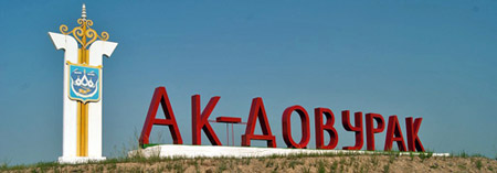
Ak-Dovurak is a city in the Republic of Tyva of the Russian Federation. It forms the urban district, the city of Ak-Dovurak, as the only settlement in its composition.
1. Ak-Dovurak Museum of Labor Glory (Музей Трудовой Славы)
This is
the primary cultural attraction in the town. As a "specialty museum"
focused on labor history, it highlights the town's industrial heritage,
particularly the asbestos mining and processing industry that defined
Ak-Dovurak. Exhibits typically cover the founding of the settlement in
the 1950s, the lives of workers, Soviet-era achievements, local history,
and perhaps Tuvan cultural elements. Such museums in Russia often
feature photos, tools, machinery models, documents, and personal stories
of "labor heroes." It's a modest but authentic window into the town's
identity.
2. Soviet-Era Monuments and Memorials
Lenin
Monument: Like many Russian towns, Ak-Dovurak has a statue of Vladimir
Lenin, a common central landmark.
Monument to the Fallen in the Great
Patriotic War (WWII Memorial): A typical Soviet memorial honoring local
residents who died in World War II, often featuring an eternal flame,
plaques, or sculptures.
Other local statues may include tributes to
workers, pioneers, or Tuvan figures (e.g., references to "Orlyonok" or
cultural symbols).
3. The Asbestos Mine and Industrial Landscape
The open-pit asbestos (chrysotile) mine and associated processing plant
are the town's defining feature. Founded in the mid-1950s as a workers'
settlement for the mine, Ak-Dovurak grew rapidly during the Soviet
period. The mine produced significant amounts of asbestos, but
operations have faced challenges since the 1990s (including closures and
restarts). The scarred industrial landscape, with its pits, tailings,
and dust, is striking (and environmentally controversial due to asbestos
health risks). Visitors are advised to take precautions against dust if
exploring nearby areas. The mine represents a classic example of Soviet
resource extraction in remote regions.
4. Natural Surroundings
and Parks
Mountain Zelenaya (Green Mountain) and surrounding
steppe/mountain terrain: The town is nestled in a valley with views of
hills and mountains. Hiking or scenic drives offer opportunities to
experience the rugged beauty of Tuva.
Park Kul'tury i Otdykha
(Culture and Recreation Park): A local green space for residents,
typical of Soviet planning, with basic amenities for relaxation.
5. House of Culture (Dom Kultury)
This multifunctional Soviet
building often serves as the social and cultural hub, housing events, a
cinema (the town's main entertainment venue), and sometimes basic
lodging for rare visitors.
Historical Context
Ak-Dovurak
was officially founded in 1956 around the asbestos deposit. It embodies
the Soviet push to industrialize remote areas of Siberia. After the
USSR's collapse, the economy struggled with the decline of the mine,
leading to social challenges. The town has a reputation in some Russian
media as a rough or "dangerous" place, though this is often exaggerated;
as with many small industrial towns, caution and local advice are
recommended for outsiders.
Atmosphere and Visitor Experience
Ak-Dovurak feels like a time capsule of Soviet urban
planning—utilitarian apartment blocks, wide streets, and industrial
remnants—set against stunning Central Asian/Siberian natural scenery.
Tuvan culture (Turkic-Mongolic influences, throat singing, shamanism,
Buddhism, and nomadic traditions) is present but stronger in rural areas
or Kyzyl. Nearby attractions include Buddhist temples (e.g., along the
Kyzyl–Ak-Dovurak route) and prehistoric rock art in the region.
Important Safety Note
Russia’s overall travel advisory (especially
from Western governments) is at the highest “Do Not Travel” level due to
security, terrorism, wrongful detention risks, and limited consular
support. Tuva is very remote, and Ak-Dovurak has a reputation—even
locally—as one of Russia’s more dangerous towns, with warnings about
crime, drunk individuals, and avoiding going out alone, especially at
night.
Strong recommendation: Only visit with a trusted local guide,
companion, or as part of an organized (and vetted) tour. Independent
travel here is high-risk and not advised for most people. Check current
advisories and register with your embassy if possible.
Best Time
to Visit
Summer (late June to mid-August): Warmest period, with
average highs around 20–22°C (68–72°F) in July. Best for outdoor
activities and travel on unpaved roads.
Winters are extremely cold
(often -20°C / -4°F or lower), with heavy snow.
Shoulder seasons can
be muddy and difficult for transport.
Tuva has a sharply continental
climate—hot summers, frigid winters, and significant temperature swings.
How to Get There
Ak-Dovurak is isolated:
Fly to Kyzyl (the
main hub in Tuva) from major Russian cities like Moscow or Novosibirsk,
then take a long road trip (4–6+ hours) west. Roads can be rough,
especially outside summer.
No major airport in Ak-Dovurak itself.
Ground transport is the norm—expect bumpy rides across stunning but
remote Tuvan landscapes (steppes, mountains).
Organized tours often
include 4x4 transfers. Public options are limited and unreliable.
Visa: Most visitors need a Russian visa (e-visa options exist for short
stays, but check eligibility and restrictions).
What to See and
Do
Options are limited due to the town’s industrial character and
lack of tourism infrastructure:
Ak-Dovurak Museum of Labor Glory
(Музей трудовой славы): A small specialty museum focused on local
history, Soviet-era labor, and the asbestos industry. One of the few
formal attractions.
Nearby natural and cultural sites in Tuva: Scenic
mountain roads (e.g., A161 toward Khakassia), prehistoric rock art in
the Sayan Canyon, or Buddhist/shamanic sites. Ak-Dovurak serves more as
a transit or overnight point for deeper exploration.
Soviet-era
architecture and remnants of the asbestos plant (now largely closed).
The town has a stark, “lost in the plateau” feel.
The surrounding
region offers throat singing (khoomei), nomadic Tuvan culture, yurts,
and dramatic landscapes, but these are better experienced elsewhere in
Tuva.
Accommodation and Practicalities
Very limited options:
No developed tourism hotels. Rare visitors often stay in basic hostels
or at the local House of Culture (which doubles as a community
center/movie theater). Security may lock doors at night.
Book in
advance through a tour operator. Expect basic facilities.
Food: Local
Tuvan cuisine emphasizes meat (especially mutton/lamb), dairy, milk tea,
and simple hearty dishes. Options are scarce—bring snacks or eat at your
lodging. Respect local hospitality if invited into homes or yurts.
Money: Cash is essential (RUB). Cards may not work reliably. ATMs are
limited.
Language: Russian and Tuvan. English is rare—use translation
apps.
Health and Environmental Concerns
Asbestos dust: The
town was built around chrysotile asbestos mining. Wind-blown dust is a
noted issue—consider face masks for protection, especially on windy
days.
Standard travel health: Vaccinations up to date, travel
insurance with medical evacuation (crucial in such a remote area), and
precautions for food/water.
Cultural Tips and Etiquette
Tuva
blends Tibetan Buddhism, shamanism, and nomadic traditions. Show respect
at religious sites.
Tuvans are often hospitable, but urban areas like
Ak-Dovurak have social challenges.
Avoid discussing sensitive topics
(politics, crime). Be modest in dress at cultural/religious spots.
Photography: Ask permission for people; be cautious with official
buildings.
Overall Visiting Tips
Go with locals or a reputable
tour: This is the single most important piece of advice. Soviet Tours
and similar operators sometimes include it in Tuva itineraries.
Short
stay: Most people use it as a stopover rather than a destination.
Pack appropriately: Layers for variable weather, sturdy shoes, insect
repellent (summer), warm gear if shoulder season, and a good first-aid
kit.
Connectivity: Limited mobile/internet in remote areas. Download
maps offline.
Why visit? For adventurous travelers seeking authentic,
off-the-beaten-path Siberia and Tuvan culture. It’s not for luxury,
comfort, or first-time Russia visitors.
Ak-Dovurak is located in the Tuva Republic (officially the Republic
of Tyva), a remote federal subject in southern Siberia, Russia,
bordering Mongolia. The region's history predates the town's founding by
millennia, shaped by nomadic Turkic peoples who inhabited the area since
ancient times. Archaeological evidence points to early Scythian
influences around 1000 BCE, with burial mounds (kurgans) scattered
across the landscape, reflecting a warrior-nomad culture known for
horsemanship, shamanism, and intricate metalwork. Tuva was part of
various empires, including the Xiongnu (3rd century BCE–1st century CE),
the Turkic Khaganate (6th–8th centuries), and later the Mongol Empire
under Genghis Khan in the 13th century. Tibetan Buddhism arrived in the
17th century via Mongolian influence, blending with indigenous
shamanistic practices that persist today.
In the modern era, Tuva was
incorporated into the Russian Empire in 1914 as the Uryankhay Kray,
following the collapse of the Qing Dynasty in China. It briefly became
the independent Tannu-Tuva People's Republic from 1921 to 1944, a
socialist state recognized only by the Soviet Union and Mongolia. During
this period, Tuva issued its own stamps and currency, and its economy
revolved around nomadic herding, fur trading, and limited mining. In
1944, amid World War II, Tuva was annexed by the Soviet Union as the
Tuvan Autonomous Oblast (later upgraded to an Autonomous Soviet
Socialist Republic in 1961). This integration brought rapid Soviet-style
industrialization, collectivization of agriculture, and suppression of
traditional religious practices, including the destruction of Buddhist
monasteries and persecution of shamans. The post-war era saw an influx
of Russian settlers and development of natural resources, setting the
stage for towns like Ak-Dovurak.
The area around what would become
Ak-Dovurak was historically sparsely populated, used primarily for
seasonal herding by Tuvan nomads along the Khemchik River valley. The
river, a left tributary of the Yenisei, provided water and fertile
pastures in an otherwise arid, mountainous basin surrounded by the
Western Sayan Mountains. Pre-Soviet life here emphasized clan-based
herding of sheep, goats, and yaks, with spiritual ties to the land
through animistic beliefs in nature spirits.
Founding and Early
Development (1950s–1960s)
The direct history of Ak-Dovurak begins in
the mid-20th century, tied inextricably to Soviet industrial ambitions.
In the early 1950s, geological surveys in western Tuva revealed vast
deposits of chrysotile asbestos in the Ak-Dovurak area, estimated among
the largest in the world. Asbestos was a critical material for Soviet
construction, insulation, and military applications, prompting rapid
development. The Tuvaasbest enterprise was established to mine and
process the resource, transforming the remote valley into an industrial
hub.
The settlement was founded in 1956 as a workers' camp to house
miners, engineers, and laborers brought in from across the USSR. Many
early residents were ethnic Russians, Ukrainians, and other Soviet
citizens relocated for the project, alongside local Tuvans. The name
"Ak-Dovurak" derives from Tuvan words meaning "white earth" or "white
field" (ak = white; dovurak = field or earth), likely referencing the
white asbestos dust that blanketed the area or the snowy steppes. By
1964, the settlement had grown sufficiently to receive official town
status, coinciding with the full operational launch of the open-pit mine
and processing plant. This period saw the construction of basic
infrastructure: apartment blocks, schools, a hospital, and roads
connecting to the regional capital, Kyzyl (301 km east). The mine, one
of the world's largest open-pit asbestos operations, employed thousands
and produced up to 250,000 tons annually at its peak, exporting
primarily within the Soviet bloc.
Early development was marked by
Soviet optimism, with the town symbolizing progress in a backward
region. However, challenges emerged quickly: harsh continental climate
(winters dropping to -40°C, summers hot and dry), isolation, and
environmental hazards from asbestos dust, which caused respiratory
issues among workers.
Soviet Era Boom and Social Changes
(1970s–1980s)
During the height of the Soviet era, Ak-Dovurak
flourished as Tuva's second-largest city and industrial center. The
population swelled to over 15,000 by the 1989 census, drawn by stable
jobs and state subsidies. The economy was monolithic, centered on
Tuvaasbest, which included mining, enrichment, and fiber production.
Ancillary industries supported the mine, such as machinery repair and
transportation. Agriculture played a minor role, with collective farms
(kolkhozes) providing food for residents.
Socially, the town
reflected Soviet multiculturalism, with Tuvans (about 80% of the
population) mixing with Slavic immigrants. However, tensions arose from
cultural clashes: forced sedentarization disrupted nomadic traditions,
and state atheism suppressed shamanism and Buddhism, though these
persisted underground. Key infrastructure projects included the
expansion of the Kyzyl-Ak-Dovurak highway in the 1970s, improving
access. The town also became a focal point for regional events, though
no major historical incidents like uprisings are recorded—unlike broader
Tuva, where anti-Soviet sentiments simmered due to collectivization
hardships.
Environmental and health concerns grew: The open-pit mine
created a massive crater, and dust pollution earned the town its "white
dust" moniker, linked to higher rates of lung diseases.
Post-Soviet Decline and Challenges (1990s–Present)
The 1991 collapse
of the USSR devastated Ak-Dovurak. Subsidies vanished, demand for
asbestos plummeted amid global health concerns, and the mine nearly
closed, leading to mass unemployment. Population declined steadily: from
15,191 in 1989 to 12,965 in 2002, 13,468 in 2010, and an estimated
12,456 in 2021—a 7.5% drop in the last decade alone. Many ethnic
Russians left for central Russia, leaving a more homogeneous Tuvan
population.
Economically, Tuvaasbest partially recovered in the 2000s
under private ownership but operates at reduced capacity, exporting to
Asia despite international bans on asbestos. Diversification efforts
have been limited, with small-scale agriculture and tourism emerging,
but poverty remains high—over 34% of Tuva's population lives below
subsistence levels. The town gained a notorious reputation as Russia's
"most dangerous" due to soaring crime rates, fueled by alcoholism, drug
abuse, unemployment, and social despair. Homicide rates in Tuva exceed
those in war-torn Chechnya, with Ak-Dovurak particularly infamous for
violent assaults, especially at night. Travelers are warned against solo
visits, with locals citing "drunk aggression" as a key risk. This stems
from post-Soviet trauma: loss of spiritual education, traditional
livelihoods, and economic stability turned Tuva into Russia's most
violent republic.
Culturally, the 1990s saw a revival of Tuvan
traditions, including throat-singing (xöömei) and shamanism, with
Ak-Dovurak hosting local festivals. Shamanic practices, involving
rituals against "curses" and spirits, reflect ongoing adaptations to
Russian influence and modern conflicts. Recent years have brought modest
improvements, such as federal investments in roads and health, but
challenges persist: environmental cleanup from mining, youth
outmigration, and integration into Russia's economy.
Location and Overview
Ak-Dovurak is a town located in the Tuva
Republic, part of the Siberian Federal District in Russia. It sits
at geographic coordinates 51°11′N 90°36′E, approximately 301 to 309
kilometers west of Kyzyl, the republic's capital. The town is
positioned in the western part of the Tuva Basin, within the central
Khemchik Valley, and serves as a key economic hub in the region,
connected by major highways such as the Abakan-Ak-Dovurak and
Kyzyl-Teeli routes. Its elevation is around 850 to 887 meters above
sea level, placing it in a relatively elevated intermontane
depression typical of southern Siberia.
Topography and
Terrain
The terrain surrounding Ak-Dovurak is characterized by a
vast, relatively flat steppe landscape within the Tuva Basin, which
is an expansive intermountain depression enclosed by mountain
ranges. To the north, the area is bordered by the Western Sayan
Mountains, which provide a dramatic backdrop and contribute to the
region's varied relief, transitioning from open grasslands to more
rugged foothills. The Khemchik Valley itself features gentle slopes
and broad plains, with occasional rocky outcrops and low hills. This
steppe environment is typical of southern Siberia, with dry
grasslands dominating the immediate vicinity, though forested areas
and higher elevations appear in the nearby mountains. The overall
topography supports limited agriculture and herding, but the
flatness facilitates transportation routes through the valley.
Hydrology
Ak-Dovurak is situated on the left bank of the
Khemchik River, a significant left tributary of the Yenisei River,
one of Russia's major waterways. The Khemchik flows through the
valley, providing a vital water source for the town and surrounding
areas. Nearby tributaries, such as the Edegeychik River, add to the
local hydrological network. The rivers in this region are fed by
mountain snowmelt and precipitation, with seasonal variations
leading to higher flows in summer and potential freezing in winter.
There are no major lakes immediately adjacent, but the broader Tuva
Basin includes various water bodies influenced by the enclosing
mountains.
Climate
Ak-Dovurak has a sharply continental
subarctic climate (Köppen classification Dfc), marked by extreme
temperature swings, low humidity, and moderate precipitation. The
average annual temperature is around -0.7°C, reflecting the harsh
Siberian conditions. Winters are frigid and dry, with January
averages featuring daily highs of -7.8°C (18°F) and lows of -17.8°C
(0°F), often dropping below -30°C. Summers are short and relatively
warm, with July highs averaging 25.6°C (78°F) and lows around 13.3°C
(56°F), though temperatures can exceed 30°C on occasion.
Precipitation totals about 279 mm annually, with the bulk falling as
rain during the wetter summer months (May to September), peaking at
around 58 mm in July. Winters see minimal precipitation, mostly as
light snow, with February being the driest. The growing season lasts
approximately 4.5 months (May to September), when temperatures
remain above freezing. Wind patterns show seasonal variation, with
stronger winds (averaging 7.3 mph) in spring (March to June),
predominantly from the west, and calmer conditions in winter.
Humidity is consistently low, with no muggy days year-round, and
cloud cover is milder in summer (clearer skies in August) compared
to the cloudier fall and winter.
Geological Features and
Natural Resources
Geologically, Ak-Dovurak is notable for the
Aktovraksky deposit of chrysotile-asbestos ores, which gives the
town its name ("white land" in Tuvan, referring to the white
asbestos fibers). This deposit is a key natural resource, supporting
mining operations for long-fiber asbestos and slate. The region's
geology is shaped by ancient tectonic activity in the Sayan-Altai
fold belt, resulting in mineral-rich formations. Surrounding areas
feature archaeological-geographical sites, including burial mounds
from the 1st millennium BC (Uyuk culture), petroglyphs from the
Bronze Age to the Middle Ages, and an 8th-9th century Uighur
fortification on the Edegeychik River banks, about 6.5 km northwest
of the town. These elements highlight the area's long history of
human interaction with the landscape, influenced by its stable
valley terrain and resource availability.
The total number of able-bodied population is 7388 people (54.2% of
city residents, 2018); the city's economy employs 2,621 people (2018).
The level of officially registered unemployment is 3.57%, according to
the methodology of the International Labor Organization - 20% (2018).
About 70% of the working population (2019) is employed in the public
sector: in public administration, education and healthcare. The volume
of shipped products of the city's enterprises is 108.1 million rubles.
(2019).
The city-forming enterprise - Mining and Processing Plant
(GOK) "Tuvaasbest" (in 1976–2014 - named after V.I. Lenin) was
launched in 1964, simultaneously with the assignment of Ak-Dovurak city
status, for the extraction and enrichment of chrysotile-asbestos ores
Aktovraksky deposit and production of long-fiber asbestos, slate and
other materials (as part of the GOK - mines, processing plant). After
1991, it experienced stagnation, after privatization and transfer to
private ownership, the work of the plant was practically stopped,
attempts were made to restore production with the help of federal and
private investments, and in 2021, part of the production facilities was
dismantled.
In Ak-Dovurak there are food industry enterprises
(bread and bakery products) and building materials industry.
The
service sector is represented by a hotel with 56 beds (2019) and small
trade enterprises.
Agricultural production in Ak-Dovurak is
concentrated in personal subsidiary plots of the population. Ak-Dovurak
has 636 personal subsidiary farms with 2,794 head of cattle (2019).
Farms of all categories harvested 122.4 tons of potatoes and 37.8 tons
of vegetables, produced 41 tons of livestock and poultry meat, 273 tons
of milk and 27 thousand eggs (2020).
In Ak-Dovurak, as well as in Kyzyl, there are four mobile operators - Beeline, MTS, MegaFon and ETK.
Near Ak-Dovurak there are burial mounds and groups (Ak-Dovurak 1–4, in the tracts of Edegey, Kozheelig-Khovu, etc.) of the 1st millennium BC - 1st millennium AD. (Uyuk culture, Turks), there are also memorial monuments in the form of fences and balbals. The locations of petroglyphs from the Bronze Age to the Middle Ages are also known (Sary-Dash, Katyn-Shat 2, etc.) 6.5 km north-west of the city, on the banks of the Edegeychik River, there is the site of Malgash-Bazhin, an Uighur fortification of the 8th–9th centuries .