Alagir is a city in the Republic of North Ossetia-Alania. The administrative center of the Alagir district. Forms Alagir urban settlement. The name of the city comes from the Ossetian "Ullag Ir", which means - Upper Ossetia (Ullag - "upper", Ir - the national name of Ossetia).
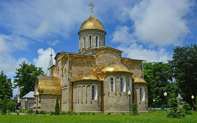
Holy Ascension Cathedral (62 Alagirskaya St.)
A white-stone
cathedral dating back to the 19th century (1850–1853), built according
to a design by the artist Grigory Gagarin. Its interior features
frescoes by the renowned Ossetian poet and artist Kosta Khetagurov
(1888–1889). It stands as one of the city's major architectural
landmarks and remains an active church of the Russian Orthodox Church.
Monuments in the City Center
Monument to V. I. Lenin (1926; later
relocated).
Monument to I. V. Stalin.
Monument to Kosta
Khetagurov.
Memorials and obelisks dedicated to soldiers of the Great
Patriotic War, including a T-34 tank.
Monuments to other prominent
local figures (Chabakhan Basieva, among others).
Alagir District
Museum and Exhibition Complex
Here, visitors can explore the city's
history, Ossetian culture, and industrial past (specifically, the
silver-lead mines).
Remains of the Factory Fortress Wall
Fragments
of the walls, towers, and embrasures of the old 19th-century Alagir
Silver-Lead Factory have been preserved in the city center; the facility
was fortified like a true fortress.
Main Attractions in the
Surrounding Area (Alagir Gorge)
The Alagir Gorge is a true "gem" of
the region and the primary reason tourists flock to this area. Carved
out by the Ardon River, the gorge is home to the Trans-Caucasian Highway
and a host of fascinating sites.
1. Monument to Uastyrdzhi (Nyhas
Uastyrdzhi)
The region's most striking and frequently photographed
attraction. This massive bronze sculpture (weighing approximately 28
tons) depicts a horseman on horseback, appearing to "burst forth" from
the sheer rock face overlooking the road. Uastyrdzhi is the central
figure of the Ossetian Nart epic, the patron of men, travelers, and
warriors (associated with Saint George). The sculpture is located near
the village of Tamisk, with cars driving directly beneath it. It makes
for a truly striking sight against the backdrop of the mountains and the
river.
2. The Alagir (Ardon) Gorge
A stunning canyon featuring
a rushing river, sheer cliffs, ancient towers, and sanctuaries. This
area is home to Ossetia’s most significant shrines:
The Rekom
Sanctuary (located in the Tsey Gorge)—one of the most important shrines
dedicated to men in Ossetia.
Mykalgabyrt and Tarandzhelos.
3.
The Tsey Gorge and Tsey Resort
A popular destination featuring ski
slopes (in winter), a cable car, glaciers (such as the Skazsky Glacier),
and breathtaking views. In the summer, it offers opportunities for
trekking and enjoying nature.
4. The Epiphany Alania Convent
A
modern convent (established in the early 2000s) situated in a
picturesque setting near the gorge. The complex includes a church, a
holy spring, a memorial, and facilities for pilgrims.
5. The
Tamisk Sanatorium and Sulfur Lake
A balneological resort renowned for
its therapeutic mineral springs. The artificial, turquoise-hued
lake—filled with sulfur-rich water and encircled by mountains—is a
beautiful spot for relaxation and photography.
6. The Zaramag
Reservoir
A large mountain reservoir featuring water that shifts in
color (ranging from turquoise to green). Several observation decks are
available for visitors.
7. Ancient Towers and Fortifications
The Nuzal Chapel (one of the oldest Christian structures in the region).
Ancestral Towers (belonging to the Tsallagov, Tuaev, Kadzaev, and other
clans). Rock fortresses and ruins in the side gorges (Ursdon Gorge,
etc.).
8. Other Natural Sites
Hot springs.
Waterfalls
(including "Three Sisters").
High-altitude lakes.
"Tsey" Federal
Nature Reserve.
Alagir is an industrial city and the administrative center of the
Alagirsky District within the Republic of North Ossetia–Alania,
Russia. It is situated on the western bank of the Ardon River,
approximately 54 kilometers west of the republic's capital,
Vladikavkaz, at coordinates 43°02′ N and 44°13′ E. Its elevation
above sea level is approximately 600 meters. The city covers an area
of roughly 27 square kilometers and lies between the Ardon River
(to the east) and the Tsraudon River (to the west), situated on the
Ossetian Sloping Plain—a foothill zone that gradually transitions
into the mountainous landscapes of the Greater Caucasus. The
Alagirsky District, in which the city is located, spans 2,135 square
kilometers across the central and southern parts of the republic; it
borders South Ossetia and Georgia to the south, rendering its
territory strategically important within the North Caucasus region.
The topography of Alagir is diverse: the city rests on a sloping
plain—a gentle foothill zone characterized by fertile soils suitable
for agriculture. However, to the south and southwest, the landscape
changes abruptly; this marks the entrance to the Alagir Gorge, a
narrow mountain valley flanked by the rocky ridges of the Caucasus
Mountains. This gorge is historically renowned for its ancient
silver-lead mines—such as the Sadon deposit—and serves as a gateway
to the higher-altitude regions. The district as a whole is
predominantly mountainous, featuring peaks well-suited for tourism
and winter sports; for instance, it is home to the Tsey ski resort,
where the slopes reach significant elevations and remain
snow-covered throughout the colder months of the year. The
surrounding mountains contribute to the formation of a microclimate,
shielding the plain from strong winds while simultaneously creating
conditions conducive to avalanches and mudflows within the gorges.
Rivers play a pivotal role in the geography of Alagir. The Ardon
River—a tributary of the Terek—flows along the city's eastern
boundary and serves as the district's primary water artery; it
originates in the high altitudes of the Caucasus and carries
meltwater from glaciers. To the west flows the Tsraudon, a smaller
river that also empties into the Ardon. These rivers provide
irrigation for the plain, though during periods of snowmelt or heavy
rainfall, they can trigger flooding. Located in the city's
vicinity—specifically in the settlement of Tamisk—is a balneological
resort featuring sulfide-sulfate-magnesium-calcium mineral springs,
which serve as indicators of geothermal activity within the region.
The surrounding vegetation encompasses forests on the mountain
slopes (predominantly coniferous and deciduous species), meadows on
the plain, and alpine pastures situated further up the gorge; this
rich biodiversity includes rare species of Caucasian flora and
fauna.
Alagir's climate is classified as humid subtropical
(Cfa according to the Köppen system), exhibiting continental
influences due to the proximity of the mountains. Summers are warm
and relatively humid: the warm season spans approximately 3.5 months
(from late May to mid-September), with daytime temperatures
consistently exceeding 22°C. July is the hottest month, during which
the average maximum temperature reaches 26°C, while the average
minimum drops to 17°C. Winters are cold and snowy: the cold season
lasts for roughly 3.7 months (from late November to mid-March), with
temperatures remaining below 7°C. January is the coldest month, with
a high of around 3°C and a low of -5°C; temperatures rarely drop
below -13°C. Precipitation is unevenly distributed: the wettest
period occurs from April to July (with up to 11.7 rainy days in June
and a precipitation peak of 81 mm), while February is the driest
month (4.2 days). Snowfall is characteristic of the period from
October to April, peaking in January (with approximately 137 mm of
snow). Cloud cover is heavier in winter and spring (reaching up to
53% in April), whereas summer tends to be clearer (with 83% clear
days in August). Humidity levels remain low for most of the year,
though conditions can feel muggy during July and August. Winds are
moderate (averaging 7 km/h) and blow predominantly from the north in
summer and from the south in winter.
Overall, Alagir’s
geography combines both lowland and mountainous elements,
positioning it as a transitional zone between the foothills and the
high mountain ranges of the Caucasus. This geographical setting
fosters the development of industry (driven by mineral resources),
tourism, and agriculture, yet it also presents challenges in the
form of natural hazards, such as landslides and soil erosion. The
surrounding region consists of other districts of North Ossetia to
the north and east, while to the south lie rugged mountain passes
leading toward the border.
In 1824 (according to other sources - in 1781), the village of
Salugardan was founded on the territory of modern Alagir, which
eventually merged with Alagir.
In the 40s of the XIX century.
the lack of lead forced the tsarist government to come to grips with
the issue of surveying the Sadonskoye silver-lead deposit in order
to find out the possibility of "supplying" the troops with their own
Russian lead.
A comprehensive study of the deposit was
carried out by the then well-known geologist Carteron and mining
engineer Reinik. They highly appreciated the possibilities of using
the deposit, and in 1843 the Sadonskoye deposit acquired state
significance, and its extensive industrial exploitation began. This
year is considered the year when the development of the Sadonskoye
mine began as a state enterprise.
The first attempt at the
industrial development of non-ferrous metal ores of the Sadonskoe
deposit was made by a private entrepreneur, a Turkish citizen, the
Greek Spiridon Chekalov. Until 1840, he was a stone contractor in
the construction of bridges on the Georgian Military Highway, where
he managed to accumulate significant capital. In 1839-1846. S.
Chekalov, with the permission of his superiors, organized the
primitive development of the ores of the Sadonskoye deposit and the
artisanal smelting of silver and lead. With the help of a small
primitive furnace, with hand fur in 1846, Chekalov was smelted and
handed over to the Treasury 11 pounds of silver and 3400 pounds of
lead, for which he received 18 thousand rubles from the treasury. He
handed over lead to the "artillery of the Caucasian Corps", and
silver - to the St. Petersburg Mint.
Primitive methods of
developing ores and smelting non-ferrous metals - silver, lead and
zinc - could not give high labor productivity. Despite the fact that
the richest ores were developed (with a lead content of up to 70%,
zinc - up to 60%), S. Chekalov's enterprise suffered a loss and in
1850 became the property of the treasury.
On the proposal of
the Caucasian governor, on February 27, 1850, the tsarist government
gave permission to establish a silver-zinc plant at the entrance to
the Alagir gorge, on the southwestern outskirts of the village of
Salugardan, on the basis of the Sadonsky deposit of polymetallic
ores.
The government allocated funds for its construction. In
addition, it was planned to build along the river. Ardon dirt road
with a length of 33 miles. The implementation of these plans was
entrusted to Lieutenant Colonel of the Corps of Mining Engineers
Ivanitsky. Under his leadership, in 1853, a metallurgical plant for
the smelting of non-ferrous metals was built near the village of
Salugardan, and a dirt road was laid from it to the Sadon mines.
The Alagir smelter was built by the Donetsk, Ural and Altai
so-called "state mining artisans" and workers. The first batch of
craftsmen and workers arrived from the Lugansk foundry in April
1850, the rest arrived later. 380 families were resettled from three
regions of the country for the construction of the plant. The
village that arose in 1850 near the plant was called "Alagir"
(Uaellag Ir - Upper Ossetia), since 1863 - the village of Alagir. By
1850 the population was about 9,000 people. Gradually, the village
of Salugardan also became part of it. By 1853, Alagir had 280
houses, which made up nine longitudinal and two transverse streets.
The first in time of foundation was Luganskaya street, later
Zlatoustovskaya, Vyatskaya, Sadovaya, etc.
In the 90s of the
XIX century. a large number of Ossetian highlanders settled on the
western outskirts of Alagir, where they formed a separate settlement
called Krupe. Along with the Russians and Ossetians, Georgians from
the Kutaisi province also began to move to Alagir. They bought plots
of land from the Russians and were mainly engaged in gardening,
farming and various crafts, and also partially worked in mines and
at a silver-lead factory. By the end of the XIX century. Alagir
became a significant settlement. It was surrounded by a moat filled
with water from the river. Ardon, it was protected by four bastions.
Three gates were made to enter the village, which were decorated
with pavilions with spiral staircases.
One of the first
historical buildings of Alagir was the church-fortress, surrounded
by a wall with loopholes and towers, built in the Byzantine style
from hewn trachyte stone according to the plan of the architect and
artist Prince Gagarin, who was at that time in the Caucasus. It was
built in 1850-1853. masons from the detachment of S. Chekalov. This
church-fortress ensemble has been completely preserved. It is
located in the central part of Alagir. It is surrounded by ancient
shady trees. This is the main historical attraction of Alagir. Now
the local history museum is located here, in which exhibits
characterizing the nature, economy and culture of Alagir and the
region are widely presented. The iconography of the church draws
attention. It was made by the hand of the great son of the Ossetian
people, Kosta Khetagurov, who was not only a wonderful poet, but
also a talented artist.
The Alagir silver-lead plant looked like a fortress. It was
surrounded by a moat filled with water, thick walls with loopholes, four
massive cast-iron gates and four corner towers on which guns stood. Part
of the buildings of the Alagir smelter has survived to this day
(Ushchelskaya Street). On the territory of the plant there were
workshops, a barracks, a forge, an office, a laboratory, a shop and an
apartment for the commander of the fortification.
Near Alagir
there was a pottery workshop that produced water pipes, as well as
bricks and tiles based on local raw materials. The Alagir silver-lead
plant, according to experts, was supposed to smelt 100 poods of silver
and 35 thousand poods of lead annually. In fact, the productivity of the
plant, as well as the Sadonsky mine, turned out to be much lower. The
plant did not justify the expense, but it was of great importance:
already during the Crimean War (1854-1855), the needs of the Russian
army for lead were provided precisely by the Alagir silver-lead plant,
which annually supplied the military department with 585 tons of lead.
The Alagir plant was the first and for many years the only large
non-ferrous metallurgy enterprise in Tsarist Russia. The plant laid the
foundations for the future multifunctional enterprise, which functioned
until 1897. In 1863, the settlement was transformed into a village, with
the assignment of the name Gornaya.
At the end of the 19th
century, Alagir was a settlement in the Vladikavkaz department of the
Terek region (52 versts from Vladikavkaz and 27 versts from the
station), and at the end of the 19th century, there were more than 27
trading establishments in Alagir in all of Ossetia.
By January 1,
1899, she was in the parish. According to Tolmachev S.I., in the
settlement lived - "a) Indigenous people 1975 souls, b) Imeretin 736
souls, c) Ossetians 949 souls, d) Raznochintsev 1998 souls."
According to the data at the beginning of the 20th century, the Alagir
settlement was listed as part of the Terek region, Vladikavkaz
department. There were 3183 inhabitants, mostly Russians, Orthodox.
There were 2 churches in the settlement (1 of them was the Ascension
Cathedral of the Exarchate), 2 schools; pharmacy; shoe repair, hotel,
post and telegraph office, state and zemstvo postal stations. Bazaar
weekly.
In December 1905, an armed uprising of peasants took
place in Alagir.
In the period 1917-1920, riots of various
political forces took place in the city.
In 1938, the settlement
was given the status of a city, and a third school was rebuilt.
During the Great Patriotic War, the city was occupied by Nazi troops on
November 1, 1942. Released on December 24, 1942, by the troops of the
Transcaucasian Front during a counterattack in the Nalchik direction. In
the post-war years, the number of residents in the city increased
several times; in the 1970s, five and nine-story residential buildings
were built in the center and at the entrance from the south side, and
school number four was built.
During the Soviet Union, the city
was one of the centers of tourists.
Alagir has always been
considered the unofficial center of the Ossetian ethnic culture and
language, all residents of different nationalities speak Ossetian.
In the late 1980s, the fifth secondary school was opened.
In
1989, by decision of the executive committee of the Alagir District
Council of People's Deputies, the cathedral was transferred to the
Russian Orthodox Church. The first divine service and solemn opening of
the Holy Ascension Cathedral was on April 29, 1989. In 1999, restoration
began: the murals were updated and the roof was completely replaced. The
great consecration of the church took place on October 8, 2000, by
Metropolitan Gedeon (Dokukin) of Stavropol and Vladikavkaz.
Since
the 1990s, new neighborhoods have been built on the outskirts of the
city for Ossetian refugees from South Ossetia and Georgia.
In
August 2008, the city became the main refugee reception center.
In 2018, the cinema "Komsomolets" was opened in a solemn atmosphere.