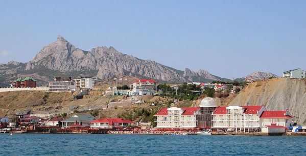
Koktebel is located in the eastern part of the Crimea. Koktebel is located on the shores of the Koktebel Bay, under Mount Klementyev. The mountain is a huge eight-kilometer horseshoe with an absolutely flat top, which surrounds the deep Barykol depression, in which ascending air currents constantly arise, rising to the top of the mountain. This place is a paradise for hang gliders. The future general designers O.K. Antonov, A.S. Yakovlev, S.V. Ilyushin, Academician S.P. Korolev flew here. At the top of the mountain there is a memorial obelisk - in honor of the first glider competitions in 1923.
By plane
The nearest airport is in Simferopol.
By train
The nearest railway station is in Feodosia.
By car
The P29
highway passes through the city.
By bus
Bus service to
Simferopol, Sudak, Kerch, Feodosia.
By bus from Simferopol.
Regular buses to Koktebel run from Simferopol railway station from 04:15
to 21:30 (interval 30 minutes - 1 hour). More detailed information can
be obtained at bus stations or in the central dispatch service by phone:
+7 (3652) 54-56-76, 54-56-80.
By bus from Feodosia. If you go to the
railway. station of Feodosia, then from it 700 m on foot to the bus
station on the Central Market. From there, suburban buses leave for
Biostation, Urochische and Nanikovo via Koktebel. Interval 15–20
minutes. There are 4 stops in Koktebel: Primorye, Bus station, turn to
the cemetery, turn to Zolotaya Balka. If you get off the train at the
Aivazovskaya station, then there is a bus station across the street from
it. Intercity buses depart from it to Sudak via Koktebel. Interval 1–1.5
hours. In Koktebel they stop only at the bus station.
Bus
station, st. Lenina, 100. ☎ +7 (36562) 2-42-83. 06:00 - 18:00. A small
stone canopy with ticket offices. E-tickets can be purchased on the
carrier's website gosbus.ru.
On the ship
You can get from
Feodosia by boat on a sightseeing or scheduled boat.
Minibuses run through the entire village, following from Feodosia to the Biostation. You can easily use them to move around the village.
The grave of M. Voloshin on Mount Kuchuk-Yenishar to the east of the
village. A hiking trail leads to it, which is loved by vacationers,
since Voloshin's grave offers beautiful views of the city and its
surroundings.
Mount Junge.
Sea excursions to the rock "Golden Gate". This arch-shaped rock got
its name due to the fact that at a certain angle of incidence of
sunlight, it really seems to be golden. She is often depicted on
souvenirs about the Crimea. Passage through the arch of the Golden Gate
on a small boat promises the fulfillment of the most secret desire. The
height of the arch is 15 meters. Located near Koktebel.
House-Museum
of Maximilian Voloshin, st. Marine 43. ☎ +7 (36562) 24-437, +7 (36562)
24-506. Summer seven days a week from 10.00 to 17.30. In winter - from
10.00 to 16.00; break from 13.00 to 14.00, day off - Monday.. Entrance
tickets - 15 UAH. (for children over 5 years old), 20 UAH. (for
students), 35 UAH. (for adults).
Dolphinarium "Koktebel", st.
Morskaya, 77 (in the area of the Aquapark on the seashore). ✉ ☎ + 7
(978) 790 39 38. Performances Tue-Sun at 11.00 and 15.00. Children's
ticket - 200 rubles, adult - 400 rubles, children under 6 years old -
free of charge. Swimming with a dolphin and a white whale - 2000 rubles.
From May to October, the dolphinarium demonstrates a program with the
Black Sea bottlenose dolphins and northern fur seals. In winter, the
pool is covered with a dome.
Water park "Koktebel", Lenin street,
144-B. ☎ 47 61 +7 (36562) 2 47 61. June until 18:00, July and August
until 20:00. Adult / child ticket: 10:00 - 18:00 1000 rubles / 600
rubles; 14:00 - 18:00 900 rubles / 500 rubles; 16:00 - 18:00 RUB 800 /
RUB 400 12 adults and 12 children's slides, 7 swimming pools, 3
jacuzzis, sun loungers, umbrellas and awnings. The slides of the water
park are distinguished by a variety of shapes, brightness, length and
speed of descent.
Factory of vintage wines "Koktebel". See the
process of making wine and taste local wines and cognacs (if you are
over 18 years old)
Sunbathe and swim in the sea. The beach strip of
Koktebel is wide, consists of sand and small pebbles. Many beaches in
Koktebel are equipped with awnings, changing rooms and sunbeds.
Festivals
The largest Ukrainian festival of contemporary ethnic and
jazz music "Jazz Koktebel" is held annually in September
During the
May holidays, the Crimean Holidays International Tango Camp is held
here, and in the fall, the Velvet Tango Festival, which attracts
Argentine tango dancers from dozens of countries.
Leisure
Skydiving
Sports club "Para-Crimea". ☎ +7 978 72-60-999, +7 978
72-68-700. Jump with a parachute type "Wing" - 3500 rubles, with a
parachute type D-1-5U (round dome) - 3500 rubles, with a parachute in
tandem - 7500 rubles.
Fly on a hang glider or paraglider on Mount
Klementyev (Uzun-Syrt).
Sports club "Para-Crimea". Flight on the
AN-2 (up to 12 people) - 12000 rubles / group, on the "Vilga" (15 min)
(3 people) - 6000 rubles, on a glider (400 m) - (1 person) 2000 rubles,
on a glider ( 800 m) - (1 person) 3500 rub.
The paragliding club
"Breeze" is open from April 1 to November 1. Standard course - 10 days.
The initial course of study is 5 flight days.
Tourist flights
(riding) in hot air balloons. 15,000 rubles (for all passengers). They
start from 2 sites: the first in the Old Crimea region (beautiful views
of Kara-Dag, Koktebel, Feodosia) and the second site in the area of the
White Rock (Ak-Kaya) near Belogorsk. 2 firms are doing this Crimean
Aeronautics Federation and another firm without a name
Company store "Koktebel". edit
Bank "RNCB", str. Lenina, 121
A. ☎ 8 800 100-90-85. Mon–Fri 9:00–18:00. There is an ATM.
ATMs
of banks "RNCB" and "Genbank", st. Lenina, 120 (sanatorium "Blue
Bay").
Most cafes and restaurants are located on the embankment of the
Koktebel Bay. Ukrainian, Russian and Crimean Tatar cuisine.
Cheap
Tablespoon".
Dining room "Fish".
Dining room "East".
"Drank-Eli".
Average cost
Cafe "Octopus".
Cafe "Emine".
Expensive
Cafe "Serdolik".
Cafe "Bohemia".
Cafe "Shinok".
Restaurant "Zodiac".
Discotheques on the embankment near the Koktebel park:
Disco Cafe
"Phoenix".
Disco Club "Troyanda".
Disco Club "Gemini" (Gemini).
Night club "Santa Fe". It works in the height of summer usually until 3
am.
Bar "Bochka".
Cheap
Private apartments.
You can put up a tent on a nudist
beach (choose a place away from the water).
Average cost
Tourist base "Primorye".
Private boarding house "Azure".
Guest
House "At Kara-Dag".
"Koktebel".
Villa Blues Hotel.
Manor
"Golden Gate".
Villa Classic Hotel.
"Favorite".
"Shanghai".
Expensive
Hotel Santorini.
Boarding house "Blue Bay".
House
of Writers.
"Galleon".
Mount Klementieva. Mecca of balloonists. Aeronautical park
"Uzun-Syrt". Aeronautic sports enthusiasts gather and train here
Karadag Reserve - adjacent to the village from the south and includes
the entire Kara-Dag mountain.
There are two main versions of the origin of the name
Koktebel. According to the first of them, Köktöbel should be
translated from the Crimean Tatar as "the edge of blue hills" (kök -
gray-blue, töbe - hill, el - edge, area). This "poetic" etymology of
the name can be found in most travel guides.
According to
Valery Bushakov, the word töbel in the Crimean Tatar language is
called an "asterisk" on the forehead of an animal, and kök töbel
means "gray [horse] with an asterisk on the forehead." This version
is supported by the village of Kara-Tobel, which existed until the
middle of the 20th century in the Dzhankoy region of Crimea (qara
töbel - "a black [horse] with an asterisk on its forehead").
Apparently, kyoktobel and karatobel are the names of the Kypchak
clans that roamed in the Middle Ages in the steppe part of the
Crimea.
The exact date of foundation of Koktebel is unknown. Ancient sources
mention the settlement of Athineon, which should have been located in
the Koktebel region, but no traces of the ancient era were found in
Koktebel.
On the Tepsen plateau, in the immediate vicinity of the
village, there was a large semi-urban Christian settlement of the Tepsen
settlement - the remains of a basilica, smaller churches, and
residential buildings are known - a total area of 17 hectares. The
settlement existed until the turn of the 9th-10th centuries, was
destroyed by the Pechenegs and revived at the end of the 12th century,
probably by the Venetians - perhaps this is Calliera or Calletra,
mentioned in some sources. On the Tepsel hill, the existence of Slavic
settlements in the 12th-13th centuries was discovered. The church,
opened on a hill, is close in its plan to the churches of Kievan Rus,
and the oven excavated in one of the dwellings resembles ancient Russian
ones. The remains of ancient Russian churches have been found in various
regions of the peninsula, most of which are located in the eastern
Crimea. Found fragments of fresco painting and plaster are close to
similar material of Kyiv cathedrals of the XI-XII centuries.
In
1360, the Venetians ceded the Crimean possessions to the Genoese. During
the reign of the Genoese between Kafa and Soldaya, Possidima, Kallitra
and Meganomé are usually indicated on the maps. The same situation
persisted after the conquest of the Genoese lands by the Ottoman Empire
in 1475.
The restoration of the settlement in the 19th century is
associated with the emergence of a Bulgarian village on the road from
Feodosia to Sudak. The Bulgarian settlers of the seaside Koktebel came
from the official Bulgarian colonies of Stary Krym (1802) and Kishlav
(1804). Apparently, they followed the Tatars, immigrants from the
Koktash volost.
On the military topographic map of Major General
Mukhin in 1817, the village of Koktebel is marked with 23 courtyards.
Charles Montandon in his "Guide to the traveler in the Crimea, decorated
with maps, plans, views and vignettes ..." of 1833 described Koktebel as
"a miserable village of 20 houses." On the map of 1836, there are 33
households in the village, and on the map of 1842, Koktebel is also
marked with 23 households. In the 1860s, after the Zemstvo reform of
Alexander II, the village of Koktebel was assigned to the Taraktash
volost.
According to the "List of Populated Places of the Tauride
Province According to the Information of 1864", compiled according to
the results of the VIII revision of 1864, Kok-Tebel is a Russian owner's
village with 8 courtyards, 27 inhabitants, a mosque, a border guard
cordon and fish factories, at the source. On the three-verst map of
1865-1876, 10 households are indicated in the village of Koktebel.
According to the results of the 10th revision of 1887, Koktebel with 7
courtyards and 34 inhabitants is recorded in the "Memorial Book of the
Tauride Province of 1889". According to the "... Memorable book of the
Tauride province for 1892" in Koktebel, which was part of the Otuz rural
society, there were 95 residents in 7 households, and in the landless
society, which was not part of the society, there were 60 residents who
did not have households. According to the "... Memorable book of the
Tauride province for 1902" in the village of Koktebel, which was part of
the Otuz rural society, there were 103 residents in 18 households. In
1914, a zemstvo school operated in the village. In the Statistical
Handbook of the Tauride Province of 1915, in the Taraktash volost of the
Feodosia district, the village of Koktebel and the eponymous estate of
F. E. Junge appear.
Since the end of the 19th century, Koktebel
has become a popular summer holiday destination. The founder of the
dacha Koktebel is a local landowner Eduard Andreyevich Junge. Since the
1880s, he began to sell part of his land for summer cottages. Since the
1890s, famous writers, artists, and scientists have been visiting the
Junge estate.
The poet and artist Maximilian Voloshin played a
special role in the development of Koktebel. He settled in Koktebel and
numerous poets, writers and other people of art visited his dacha,
Alexei Tolstoy, Vikenty Veresaev, Marina Tsvetaeva, Mikhail Bulgakov,
Nikolai Gumilyov, Sofia Parnok, Nikolai Chukovsky and many other famous
cultural figures. Some of the inhabitants of this dacha at the very
beginning of the 20th century (even before the October Revolution) made
a certain contribution to the development of nudism.
The
settlement gained great fame and representatives of the world of arts
and science began to build summer cottages or settle here. After
Voloshin's death, his widow continued to receive these guests, and in
the 1930s his dacha was transformed into the Koktebel Writers'
Creativity House, which still exists today. According to the Statistical
handbook of the Tauride province. Part II-I. Statistical essay, issue of
the fifth Feodosia district, 1915, in the village of Koktebel, Taraktash
volost, Feodosia district, there were 62 households with a Bulgarian
population of 263 registered residents and 59 "outsiders".
After
the establishment of Soviet power in Crimea, by a decree of the
Krymrevkom of January 8, 1921[40], the volost system was abolished and
the village became part of the newly created Vladislavovsky district of
the Feodosiya district, and in 1922 the districts were named districts.
On October 11, 1923, according to the decree of the All-Russian Central
Executive Committee, changes were made to the administrative division of
the Crimean ASSR, as a result of which the districts were liquidated and
the Vladislavovsky district became an independent administrative unit.
Decree of the All-Russian Central Executive Committee of September 4,
1924 "On the abolition of some areas of the Autonomous Crimean S. S. R."
in October 1924, the district was transformed into Feodosia and the
village was included in it. According to the List of settlements of the
Crimean ASSR according to the All-Union census on December 17, 1926, in
the village of Koktebel, the center of the Koktebel village council of
the Feodosia region, there were 162 households, of which 107 were
peasants, the population was 686 people, of which 402 Bulgarians, 170
Russians, 76 Greeks, 12 Tatars, 14 Ukrainians, 4 Jews, 2 Germans, 6 are
recorded in the “other” column. Koktebel-resort appears separately in
the census, with 55 households and 125 inhabitants (91 Russians, 16
Ukrainians, 11 Greeks, 4 Bulgarians, 1 Jew, 1 Latvian and 1 German).
There was also a Koktebel farm with 1 yard, 6 inhabitants and a Russian
school of the 1st stage (five-year plan), apparently, the farm consisted
of one school.
By the Decree of the All-Russian Central Executive
Committee “On the reorganization of the network of regions of the
Crimean ASSR” dated October 30, 1930, the Staro-Krymsky region was
separated (recreated) from the Feodosia region (according to other
sources, September 15, 1931) and the village was included in the
composition. In the 1920s - 1930s, Koktebel, thanks to constant updrafts
on the Uzun-Syrt plateau, became the center of gliding. In September -
October 1929, the pilot and artist, grandson of I.K. Aivazovsky
Konstantin Konstantinovich Artseulov here lifts into the air a glider
designed by Sergei Pavlovich Korolev and Sergei Lyushin.
There is
evidence that Koktebel became an urban-type settlement in 1938 according
to other sources - since 1960.
In 1944, after the liberation of
the Crimea from the Nazis, according to the Decree of the State Defense
Committee No. 5984ss of June 2, 1944, on June 27, the Crimean Bulgarians
and Crimean Greeks were deported to Central Asia. On August 12, 1944,
Decree No. GOKO-6372s “On the resettlement of collective farmers in the
regions of Crimea” was adopted, according to which 1900 people moved to
the Starokrymsky district from the Rostov and Kursk regions and in
September of the same year the first new settlers (212 families) arrived
in the district, and in the early 1950s, a second wave of immigrants
from various regions of the Ukrainian SSR followed. By a decree of the
Presidium of the Supreme Soviet of the RSFSR dated August 21, 1945,
Koktebel was renamed into Planerskoye, and the Koktebel village council
- into Planersky. On June 25, 1946, Planerskoye was part of the Crimean
region of the RSFSR, and on April 26, 1954, the Crimean region was
transferred from the RSFSR to the Ukrainian SSR. In 1959, the
Starokrymsky district was liquidated and the village was annexed to
Sudaksky. By the Decree of the Presidium of the Supreme Council of the
Ukrainian SSR “On the consolidation of rural areas of the Crimean
region”, dated December 30, 1962, the Sudak region was abolished and the
village was included in the Alushta region. On January 1, 1965, by
decree of the Presidium of the Supreme Soviet of the Ukrainian SSR “On
Amendments to the Administrative Regionalization of the Ukrainian SSR -
in the Crimean Region”, Planerskoye was transferred to the Feodosia City
Council.
Since February 12, 1991, a village in the restored
Crimean Autonomous Soviet Socialist Republic, renamed the Autonomous
Republic of Crimea on February 26, 1992. By the Decree of the Supreme
Council of Crimea dated July 1, 1992 No. 112-1, the historical name was
returned to the village. Since March 18, 2014 - as part of the Republic
of Crimea of Russia, since June 5, 2014 - in the urban district of
Feodosia.
After the annexation of Crimea to Russia, the Koktebel
village council was abolished within the framework of the Russian
municipal structure. Before that, he had his own budget, but after the
incident, the budgets of Koktebel and Feodosia were merged into one
joint one within the city district, due to which the improvement of
Koktebel gradually began to deteriorate.
It is located on the Black Sea coast, 20 km southwest of Feodosia, on
the coastal road 35K-005 Alushta - Feodosia (according to the Ukrainian
classification - P-29), on the shores of the Koktebel Bay, at the foot
of the Karadag volcanic massif.
The Koktebel Bay is open to the
southeast, bounded from the east by the narrow cape Kiik-Atlama, on
which the urban-type settlement of Ordzhonikidze is located. The Karadag
mountain range limits the bay from the southwest and is largely covered
with forest, rich in rare plants and animals. The Karadag mountain range
is a nature reserve and access there is open only with excursions.
From the north and east, Koktebel is surrounded by steppe mountains
interspersed with vineyards. In the north-west rises the rocky mountain
Tatar-Khaburga (height 236 m) and the lower mountains Malka (height 123
m) and Eger-Oba (height 116 m), the latter practically adjoin the
buildings of the village.
To the north of the city is the Uzun
Syrt ridge with the highest point of Mount Klementyev. Often blowing
steady winds from the sea create ascending air currents on this
mountain, making this place extremely convenient for gliding, which has
been actively developing both in Soviet times and in the present in a
variety of forms (hang gliders, paragliders, etc.). In the northeast,
along the Koktebel Bay, the Kuchuk-Enyshar ridge stretches (height 192
m). Two streams flow through the village.