Location: 30 km (19 mi) North of Trnava Map
Dobrá Voda Castle, also historically known as Jókő or "Good Stone," is a ruined Gothic fortress situated on a rocky hill in the Little Carpathians mountain range in southwestern Slovakia, near the village of Dobrá Voda in the Trnava Region. Perched at an elevation of about 320 meters above sea level, it overlooks the surrounding landscape and was strategically positioned along an ancient trade route connecting Hungary to Moravia. The castle's name derives from a nearby spring with reputedly healing waters, tied to local legends. Today, it stands as a preserved ruin, accessible to visitors for free, showcasing remnants of its medieval architecture amidst forested terrain.
Construction and Early History (13th-14th Centuries)
The origins
of Dobrá Voda trace back to the mid-13th century, during a turbulent
period in the Kingdom of Hungary following the Mongol invasion of
1241-1242. The castle was constructed between the 1260s and the turn of
the 13th and 14th centuries, likely on the site of an earlier
fortification or refuge. It was built by Aba the "Beautiful" (Aba
Amadé), founder of the Hlohovec branch of the powerful Aba clan, who
received the land grant from King Béla IV as a reward for loyalty during
the invasion's aftermath. The first documented mention of the site as a
border point appears in 1262, but the castle itself is referenced in
1316 under the name "Ioku" (meaning "Good Stone" in Hungarian), managed
by castellan Štěpán on behalf of zupan Mikuláš.
A local legend adds a
romantic layer: the castle was purportedly erected by the lover of a
village girl who used water from the nearby spring to cure the king,
earning the site its name "Dobrá Voda" (Good Water). Architecturally,
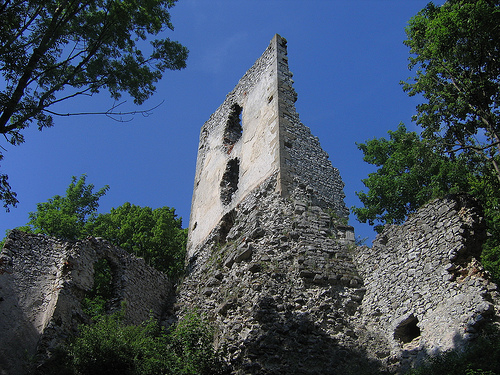
the initial structure was a Gothic sentry castle made of limestone,
featuring a core upper ward with two prismatic towers flanking an oblong
residential palace. The western tower measured about 9.2 x 9.8 meters
with five floors and buttresses, while the eastern one was 7.7 x 7.7
meters with four floors. Thick walls (1.9-2.5 meters) included defensive
elements like loopholes and crenellated battlements. A small courtyard
with a cistern and possible Gothic chapel adjoined the eastern tower,
forming a fortified residence. The entrance was protected by a simple
barbican and a western forecastle with a cannon bastion.
In the early
14th century, the castle became entangled in the power struggles of
Hungarian oligarchs. The Aba family aligned with the influential Matthew
III Csák (Máté Csák), but tensions escalated. On June 15, 1312, Aba the
Beautiful died at the Battle of Rozhanovce (Rozgony), where Csák's
forces were defeated by King Charles I Robert of Anjou. In 1316, Csák
besieged and occupied Dobrá Voda through negotiations, incorporating it
into his domain along with other regional strongholds. After Csák's
death in 1321, the castle reverted to royal control under Charles
Robert, with a royal castellan documented by 1354.
Ownership
Changes and Expansions (14th-16th Centuries)
The late 14th century
brought further shifts amid dynastic conflicts. In 1386, during the
succession crisis after King Louis I's death, Queen Mary pawned the
castle (as part of Pozsony County) to Moravian marquesses Jodok and
Prokop for political support. King Sigismund of Luxembourg repaid the
debt in 1390 but had to besiege and reclaim it when Prokop refused to
relinquish control. By 1394, Sigismund donated Dobrá Voda and its
estate—encompassing ten villages—to his loyal Transylvanian voivode,
Stibor of Stiborice (Stiboricz), a Polish noble who used it as a
secondary seat while based at Beckov Castle. In 1403, during a rebellion
against Sigismund, the castle's castellan sided with the opposition,
leading to its forcible reconquest by royal forces.
Stibor's family
held it until 1434, when his son died childless, returning it to the
crown. In 1436, it passed to the Országh (Ország) family of Gút, who
owned it for over a century until their male line extinguished in 1567
with the death of Kristóf Ország. Under the Országhs, significant
expansions occurred, including mid-14th-century perimeter walls and
residential enhancements in the upper ward, such as three-story palace
additions with fireplaces and windows. The estate grew economically, but
the castle faced new threats from Ottoman incursions after the 1526
Battle of Mohács, which fragmented Hungary.
Post-1567, ownership
transitioned rapidly. King Maximilian pawned it to Croatian noble Ján
Choron of Deveč. In 1583, Croatian ban Krsto Ungnad acquired it for
70,000 guldens from King Rudolph, along with associated properties.
Through Ungnad's daughter Anna Mária's marriage to Tamás Erdődy—a hero
of the anti-Ottoman wars—the castle entered the Erdődy family's
possession. The Erdődys made it an administrative hub for their estates,
adding fortifications in the second half of the 16th century due to
Ottoman threats: a southern ward (100 x 50 meters) with defensive walls,
two semicircular cannon towers (later expanded to three floors), a
ditch, rampart, and auxiliary buildings. The access road featured four
gated serpentines for defense.
Later History, Conflicts, and
Decline (17th-19th Centuries)
By the 17th century, under Erdődy
control, the castle's garrison was bolstered, with last major
constructions in 1657 under Countess Erdődy Gáborné. It escaped
destruction in 1702 thanks to the family's Habsburg loyalty during
Emperor Leopold I's decrees against rebel fortresses. However, during
Francis II Rákóczi's War of Independence (1703-1711), it repelled rebels
but sustained damage from war events.
As the Erdődys acquired more
comfortable manor houses, they abandoned Dobrá Voda by the late 17th or
early 18th century. Residents relocated to a palace in Galgóc by 1787. A
devastating fire, possibly triggered by lightning, struck in 1762,
destroying much of the structure. Briefly repurposed as a prison for
nobility, it was fully abandoned by the early 19th century. In 1855, it
passed to Count Pálffy József, whose family repurposed its stones for
other buildings, accelerating ruin. No major archaeological excavations
are noted, but the site retains visible remnants: perimeter walls of the
upper, eastern, western, and partial southern wards; tower stubs; palace
foundations; and cannon towers.
Dobrá Voda Castle, also known historically as "Ioku" or Dobrý Kameň,
is a ruined Gothic castle situated on a high, rocky hill in the central
part of the Little Carpathians mountain range in Slovakia, overlooking
the village of Dobrá Voda in the Trnava district. Constructed in the
late 13th century (likely between the 1260s and the turn of the
13th-14th centuries) on the site of an earlier fortification, it served
primarily as a guarding castle along a strategic trade route from
Hungary to Moravia. The castle's name derives from the abundant water
springs in the area ("Dobrá Voda" meaning "Good Water" in Slovak). Its
location on a ridge protected by deep gorges on three sides made it
naturally defensible, with the southern slopes being the most
accessible. The structure evolved from a simple Romanesque-Gothic core
into a more complex fortified complex through expansions in the
14th-17th centuries, incorporating Renaissance and later elements before
falling into ruin after a fire in 1762 and abandonment in the early 19th
century. Today, it stands as a picturesque ruin, with preserved walls,
towers, and fortifications offering insights into medieval Slovak
architecture.
The castle's overall layout is elongated, adapting to
the rocky terrain, and can be divided into several key wards: the upper
castle (core), eastern outer ward, western ward, and southern ward. It
was built primarily from limestone, with walls featuring ashlar
reinforcement in key areas. Defensive elements include thick perimeter
walls, towers adapted for firearms, bastions, and a system of gates
connected by serpentine paths for layered defense. Residential and
economic functions were integrated, with palaces, chapels, cisterns, and
outbuildings. The architecture reflects phases of construction: initial
Gothic elements in the 13th-14th centuries, fortifications enhanced in
the 15th century against Ottoman threats, and economic expansions in the
16th-17th centuries.
Upper Castle (Core)
The upper castle
forms the oldest and highest part of the complex, situated on the rock
ridge at the hill's summit. By the second half of the 14th century, it
consisted of an elongated residential building flanked by two prismatic
(four-sided) towers, with an oblong palace in between. This core was
surrounded by a solid defensive wall that originally enclosed the
hilltop up to an eastern promontory, crowned with crenellations and a
wall-walk for defenders.
Western Tower: The larger of the two,
measuring 9.2 x 9.8 meters externally, with walls 1.9-2.5 meters thick
on the ground floor. Its corners are reinforced with ashlar blocks, and
it features massive buttresses for structural support. It had five
floors, including an attic level, serving both defensive and residential
purposes. The tower's design allowed for multi-level combat, with
potential loopholes or windows for archers.
Eastern Tower: The oldest
surviving element, square in plan at 7.7 x 7.7 meters, with similarly
thick walls (1.9-2.5 meters). It comprised four floors: the second floor
was vaulted for added strength, while others used wooden ceilings.
Originally topped with a battlement for defense, it also had residential
functions. A well or rainwater cistern is integrated into a bend in its
wall.
Middle Palace: Positioned between the towers, this oblong
structure was divided into three floors. The upper two levels were
likely for residential and representative uses, featuring fireplaces for
heating and windows with stone side seats for comfort. Floors were
separated by wooden ceilings supported on stone consoles. A narrow
eastern passage connected it to the eastern tower, facilitating internal
movement.
Additional features in the upper castle include a small
yard adjacent to the eastern tower with a well-preserved cistern and
sink for water collection. The northern wall of the palace remains the
most intact today. In the mid-14th century, the defensive wall was
raised, adding two combat levels on the northern side (a lower one on an
offset and an upper with beam sockets for flooring). A postern gate
behind the main tower provided access to a steep path down the gorge.
The upper castle was later widened westward with a forecastle and
fortified with a cannon bastion to counter artillery threats.
Eastern Outer Ward
Extending eastward from the upper castle, this
courtyard area was filled with a three-story building along the facade
at the northern wall's turn. The three-sided wall end suggests it may
have housed a Gothic chapel or served a defensive role, overlooking the
access road through the valley below. A small four-sided tower protrudes
from the northern wall, likely for guarding the gorge. The ward's walls
featured a blinded (walled-up) battlement from the 15th century,
indicating later height increases for improved defense.
Western
Ward
Developed in the first half of the 15th century, this ward
fortified the original western gate access, which crossed via a wooden
bridge due to the terrain drop. It focused on entrance defense, adapting
to emerging firearm technology.
Gatehouse: A corner four-sided
structure with ashlar-reinforced corners, flanked by a semi-cylindrical
tower modified for cannons. It had three floors with radially arranged
loopholes to cover the southern foreground. Entry was via a drawbridge
leading to a vaulted passage.
Foregate: Added in the 16th century,
this elongated extension descended southeast, ending in a small internal
tower for added security.
Curtain Walls: The ward's walls include a
drainage hole and a 15th-century blinded battlement. Domestic buildings
were present for support functions.
The access road to the upper
castle wound through four gates connected by serpentine paths with
straight stretches, allowing defenders to fire from elevated positions.
Southern Ward
Constructed in the second half of the 16th century
to accommodate growing economic needs, this extensive lower castle area
measures approximately 100 x 50 meters. It was secured against Ottoman
threats with a defensive wall featuring two semicircular cannon towers
(bastions) strongly projected southward.
Cannon Towers: Initially
two floors, with rear sections open or screened by wood; a possible
third smaller tower guarded the western entrance gate. The southwest
tower was rebuilt in the 17th century for residential use, adding two
upper floors.
Fortifications: Protected by an outer ditch and clay
rampart. The ward housed domestic buildings for economic purposes and a
small chapel.
This ward reflects the shift toward artillery
defense in the Renaissance period.