Location: Western Carpathians region
Tatra Mountains is the highest mountain range in the Carpathians. Tatra Mountains are situated on the border between Poland and Slovakia. Difficult terrain and high elevation made this part of Europe difficult to settle and cultivate so much of the biosphere is well preserved. The region is home to wild boar, brown bear, wolf, lynx, marmot and different species of deer. Additionally there are over 200 species of birds, 162 species of spiders and many others. Slovakian side of the Tatra mountain range consists of Western Tatras (Zapadne Tatry), the High Tatras (Vysoke Tatry) and Belianske Tatry. The last is a small area that is strictly protected. It is closed to the public.
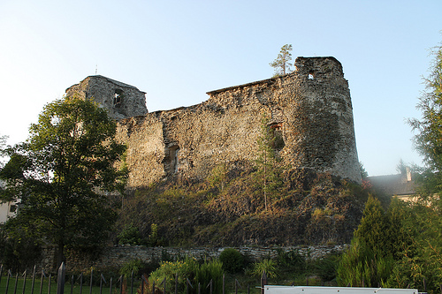
Liptovsky Hradok is a medieval citadel situated in a Liptovský Mikuláš District in Tatra Mountains. It was constructed in 14th century. Changing military tactics and technology changed the purpose of the castle defenses. It was transformed into Renaissance palace by Louis XVI. Today it houses a Ethnography Museum.
At 2655 m it is the tallest peak in the Tatras mountain range.
At 2634 m high this peak is second in the range and easier to rich by cable cars. Bring warm clothes. Even in summer winds are merciless.
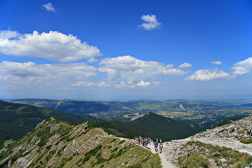
Stary Smokovec is one of the most popular and attractive spa complex in the Tatra Mountains. Set in the pristine mountains and virgin forests it offers great degree of tranquility and peace in this beautiful region.
The origin and meaning of the name Tatra has not yet been reliably
clarified. Historians attribute it to the inhabitants who lived on the
territory of Slovakia even before the arrival of the Slavs. They derive
it from the Aryan word tamtra, tâtra meaning "dark" or "dark", they
attribute to it a meaning derived from the folk word tatra meaning
stony, barren land. The most probable opinion is that the name Tatra
comes from the Slavic word trtri, which means steep.
The first
mention of this name is from the year 999, when the Czech prince
Boleslav II. on his deathbed he remembers the time when the Czech
Principality reached Tritri montes. The name Tatras itself is mentioned
for the first time in 1086 in the donation deed of the German emperor
Henry IV, who also demarcated the Prague diocese with the Tritri
mountains.
The first very brief preserved account of the Turtur
Mountains was recorded in his historical manuscript by an anonymous
scribe of the Hungarian king Bela III. The chronicle, which he called
the Gesta Hungarorum and was created only after Bela's death, tries to
present in a celebratory way the history of Hungarian conquests reaching
up to our mountains. It contains many myths and distorted reports, but
on the other hand, it also contains specific information about the life
of the Slavic population, specifically in the Vag valley (Váh) and in
the capital Zepis (Spiš).
Under its current name, in the
transcription Tatri, the High Tatras are mentioned for the first time in
the Latin chronicle about Bohemia - Chronica Boeomorum, written between
1119 and 1125. It was written by the Czech chronicler Kosmas (c. 1045 -
1125), a canon and dean of the Prague chapter. The chronicle quotes the
text of the so-called of the founding document of the Prague bishopric
with a description of the northern borders of Slovakia, or Hungary,
while also mentioning the Tatras and Považie (province of Vag).
When Slovakia was occupied by Hungarian cavalry, the Hungarian monarch
became the first official owner of the Tatras. He later distributed them
to his favorites. With the oldest known donation from 1209, the Spiš
provost Adolf and his sister, the wife of commissar Rutker (Rudiger), a
former lady-in-waiting to Queen Gertrude, received a gift from Ondrej
II. extensive property on the territory of Spiš with both Studený
dolina, Skalnata dolina and adjacent hills, including Lomnické štít. The
original document has not been preserved. Its authenticated description
is stored in the Hungarian Central Archives in Budapest in the Berzevici
fund under the signature D1 – 68752. It describes the boundaries of the
Lomic manor, which go to "ad priores niveos montes" (that is, to the
ridges of the Tatras). Veľká Lomnica was the seat of the oldest manor,
historically documented in 1257, at the same time as the Huncovci.
Descendants of Rutker and his wife were the Berzevici nobles from Spiš.
Veľhory is surrounded from the north by the Podtatranská brázda, to
the west by the Chočské vrchy, to the south lies the vast Podtatranská
kotlina, and to the east is connected by the mountainous Spišská Magura.
The relief of the Tatras is the result of water courses and mountain
glaciers, which divided the mountain range into several ridges and
jagged ridges. Three ice ages and two interglacials have been
identified. Traces of the oldest known glaciation were found in the form
of a very weathered moraine accumulation below the mouth of the Cold
Valley in the area above Horný Smokovec. Moraines of the penultimate
glaciation occur more often. The glacier in the Bielovodská valley ended
at about 895 m above sea level. m., was 14 km long and 330 m thick. It
was 10.1 km long in Javorova dolina. At the time of their greatest
extent, the glaciers in the High Tatras had an area of about 15,000
ha, and after their dissolution, sediments and lakes remained in the
High Tatras, but also in other parts of the Tatras. The largest are on
the northern, Polish side of the Tatras. The territory of the Tatras
belongs to the basin of the Black Sea (rivers Váh and Orava) and the
Baltic Sea (Dunajec and Poprad). The main ridge of the Tatras is 75 km
long and stretches from the Hutianske saddle (905 m above sea level) in
the west to the Pod Príslopom saddle in the east (1,081 m above sea
level). Its westernmost peak is Sivý vrch (1,805 m a.s.l.), the
easternmost is Muráň (1,889.6 m a.s.l.). From the main Tatra ridge,
ridges run out.
The Tatras geomorphological unit is divided into
two sub-units: the Western Tatras and the Eastern Tatras, separated by
the Ľalio saddle (1,947 m above sea level). The East Tatras sub-unit is
divided into two High Tatras and Belianske Tatras, separated by the
Kopské saddle (1,749 m above sea level). The ridge of the High Tatras is
26 km long and begins in the west with the Ľalio saddle. The first
terminus in the west is Svinica, the last terminus in the east is
Jahňací štít. The limestone ridge of the Belianske Tatras measures
almost 14 km and Široké sedlo divides it into two parts. The western
part has a strong rugged relief, the eastern part has a less rugged
surface.
The Tatras belong to the outer part of the Tatra-Fatran mountain
range. They are built with the rocks of three important geological
mega-units: Tatrikum as a base is formed by crystalline rocks and their
sedimentary cover, through which the sub-Tatran blankets, the lower
Krijňan (fatrikum) and the upper Choč (chronicum) are moved. The
blankets are formed mainly by Mesozoic carbonates - limestones and
dolomites. The Tatras are geologically divided into two zones, the
southern predominantly crystalline Rohác-Vysokotatra zone and the
northern sub-Tatra zone, built by Mesozoic blankets.
The oldest
crystalline tatrika units occur mainly in the western part of the
mountain range. They are represented by two lithotectonic units, the
upper one, more metamorphosed (the Baranec complex) is made up of
migmatites and granites, the lower one (the Jalovek complex), less
metamorphosed, visible only in the tectonic window (Liptovské Tatras),
is made up of clasts and gneisses, transformed into flysch rocks. Both
metamorphic units meet along a shear zone estimated to be Devonian to
Carboniferous in age, corresponding to late Hercynian movements. The
continental cover Toman unit is placed on the crystalline. Partial
blankets of the Červený vrchy, Giewont and Široka are also present. In
the Western Tatras, the Osobitá unit occurs, which has basic volcanics -
limburgites - developed at the boundary between the Jurassic and the
Cretaceous.
The fatrik and hronika blankets were superimposed on
the tatrikum in the Upper Cretaceous. Covers formed mainly by limestone
and dolomite are preserved especially on the northern and eastern sides
of the Tatras. Here, the Krížňany blanket (fatrikum) consists of several
partial blankets - the Bujačian, Bobrovecky and partial Suchego Wierch
blanket. Only the Białovac sequence is present in the Tatras from the
upper Choč cover (Chronicle). In the Paleogene, there were movements
along fault faults, which caused subsidence of the Liptovská and
Podhalská basins. In the Neogene, especially in the lower and middle
Miocene, rock movements occurred during the final phases of Alpine
folding, which resulted in the formation of asymmetric heath in the area
of the East Tatras-Ružbaš and West Tatras-Koprov faults. During this
period, the Tatras rose by 1,000 to 1,500 m compared to their
surroundings, while the eastern part rose more than the western part.
The kinematics of these movements is still the subject of expert
discussions. The Tatras are surrounded by young formations of the
sub-Tatra group.
The mountainous character of the relief of the
mountain range, especially on the eastern side, is caused by the
activity of mountain glaciers, whose activity was manifested during
several ice ages during the Pleistocene. However, the traces of the last
two ice ages (ris and würm) are the best preserved. There were a total
of 41 mountain glaciers that flowed down valleys, cutting into the
subsoil and thus creating characteristic U-shaped valleys, the so-called
troughs. The largest of them was up to 19 km long, located in the
Bielovodská valley. The deposits of this period reach a thickness of
around 400 m in places. Somewhere, interesting geological phenomena can
be observed in the streambeds, the so-called giant pots. Unsorted
moraine mounds carried by glaciers are visible in several places,
consisting of material of various sizes, from huge boulders, gravel,
clay to fine-grained clay. After warming at the beginning of the
Holocene, the glaciers melted. In some places, glacial lakes have
formed.
Geological processes had a significant impact on
morphology and relief. In the lower western part, smoothly modeled
valleys and ridges with so-called hólným relief, in the eastern part,
where the glaciation was more intense, it was reshaped into a
predominantly craggy glacial relief.
In some contemporary travelogues, botanical and natural history
works, there are mentions of ore occurrences in Tatra valleys or on rock
massifs. Some were practically used, especially in the 17th and 18th
centuries. However, it was not the bearings. Those in the Tatras have
not been discovered to this day. These were ore occurrences that were
used sporadically in the past, and only in very small quantities at the
level of the time. The first mentions of mining activity are from the
13th century. The rulers of the time, who were the owners of mineral
wealth, issued mining permits. The first mention of specific mining
activity in the area of Kriváň dates from 1387 – 1437. Under King
Matej I Corvín, the tunnels of the Glücksrad company were in operation
around the Škaredé chute, where Jakub Fuger mined.
There were
iron ore mines near Štrba, and there were copper mines on Patria, which
was called Kupfenberg, which belonged to the Benedictine monastery in
Štôla. In the 16th century, miners from Spiš and from the Polish side of
the Tatras were interested in ore deposits. A company from Podhalia,
Poland, led by Michal Spis from Nové Targ, mined in the Bielovodská
valley since 1524. Activities in the area of Kriváň were larger, where
antimony ore was found, and gold was bound to it. The yield from the
mines was not great. That is why the owners took turns with the hope of
discovering abundant deposits. However, they soon tried to get rid of
unpromising activities.
After numerous scientific and geological
investigations, it can be concluded that the ore occurrences have only
mineralogical significance and do not correspond to the criteria of a
deposit of mineral raw materials.
Copper ores
Their known
occurrence is Predné and Zadné Meďodoly. The reddening is in the Kopské
sedl and on the northern slopes of Jahňacie štít. These are small veins
of quartz with chalcopyrite and pyrite. Similar occurrences are on the
northern slopes of Veľká Svisťovka and in the Biely plies area. Copper
ore was also mined in the vicinity of the Zlatinská tower and in the
Mengusovská valley.
Iron ores
It is a hydrothermal type of
siderite reddening of copper ores, in which the mineral tetrahedrite and
pyrite also occur sporadically. Such occurrences are in Javorov sedl on
Jahňač štít, the Front and Back Cress Towers, in the vicinity of
Lomnické štít, in Ľadov sedl and Barání rokh. There are also small
remains in Mala Studeña dolina. All of them are insignificant from a
practical point of view.
Antimony ores
This is an ore deposit
that is known in the Kriváň region. It is mainly represented by
antimonite, which always binds a certain amount of gold.
Gold
ores
Gold was the biggest attraction for the presence of miners in
the Tatras. In the literature, the occurrence of gold in Sedielka, in
Medený lávky and in Mala Studená dolina is described. It occurs in the
area of Kriváň. These are quartz veins in mylonites. Antimonite,
galena, sphalerite, arsenopyrite and pure gold appear in the veins.
The Tatras are part of the watershed between the Black and Baltic
Seas. Flows peak in May and June. The most important mountain stream of
the Tatras is Belá, which drains the Kôprová, Tichú, Kamenistá, Bystrá,
Račková and Jamnícka valleys. It then flows into the Váh near Liptovský
Hrádek. In addition to it, there are also Oravica and Studený potok,
which flow into Orava.
There are other mountain streams that flow
into the Poprad River: Mlynica, Velický potok, Studený potok, Kežmarská
Biela voda and Biela. Dunajec is supplied with water by Biela voda
poduplazská and Javorinka.
Lakes of glacial origin in the Tatras have their own names, pleso in Slovakia and staw in Poland. There are more than 200 mosses here, mainly in higher positions, where they mostly formed in glacial caldera, or lower in depressions surrounded by moraines. The largest is Morské oko (Polish: Morskie oko) in Poland with an area of 34.54 ha, a depth of 50.8 m, located at an altitude of 1,395.4 m above sea level. m.. The largest in Slovakia are Veľké Hincovo pleso (20.08 ha, 53 m, 1,946 m above sea level) in Mengusovská dolina, as well as Nižné and Vyšné Temnosmrečinské pleso, but the most famous are Štrbské pleso (19.76 ha), Popradské pleso ( 6.88 ha), Zelené pleso and Skalnaté pleso.
The most famous waterfalls include:
Vajanského waterfall
Studené potok waterfalls
A huge waterfall at the mouth of Studený
potok
Skok waterfall in Mlynicka dolina
Rohác waterfall
Kmeťov
waterfall
Great Siklawa
Wodogrzmoty Mickiewicz
In the Tatras, we register about 1,400 plant species, among them
relicts and endemics.
Tertiary relics (glacial relics from the
Ice Age) are, for example, primrose (Primula farinosa), primrose
(Delphinium oxysepallum), dryad (Dryas octopetala), alpine bearberry
(Arctous alpina), rooting buttercup (Ranunculus reptans).
endemics
include: Primula halleri subsp. platyphyla, Oxytropis camoperstris ssp.
tatrae, Ranunculus altitatrensis, Euphrasia exaristata.
West
Carpathian endemics: perennial saxifraga (Saxifraga wahlenbergii), Tatra
gorse (Delphinium oxysepallum), glossy clove (Dianthus nitidus), Tatra
poppy (Papaver tatricum).
Most of the territory of TANAP and TPN is
covered by coniferous forests, in high places by pine (Pinus mugo), and
in the highest places there are no forests anymore.
Many animal species live in the Tatras, which can be found elsewhere,
as well as endemics.
Among the rarest endemics is the High Tatra
chamois (Rupicapra rupicapra tatrica), whose abundance varies according
to conditions to around 1000 individuals. A smaller group of this
species was also planted in the Low Tatras. In the Tatras, there are
also mountain roe deer (Capreolus capreolus), red deer (Cervus elaphus),
high Tatra marmot (Marmota marmota latirostris), Tatra vole and Tatra
snow vole (Microtus nivalis mirhanreini).
Of the large animals, the
lynx (Lynx lynx), the common wolf (Canis lupus), the brown bear (Ursus
arctos), and the wild cat (Felis silvestris). Birds of prey include the
golden eagle (Aquila chrysaetus), the peregrine falcon (Falco
peregrinus), and the buzzard (Falco tinnunculus). Among the owls, there
are sparrowhawks (Glaucidium passerinum), tawny owls (Bubo bubo), wood
owls (Strix aluco).
River otter (Lutra lutra) and others can be
found here. Brown trout (Salmo trutta) is also found in Tatra streams.
All plants and animals are strictly protected year-round on the
territory of TANAP.
On November 19, 2004, a windstorm with a
speed of 165 to 227 km/h hit the Tatras, uprooting large areas of forest
from Podbanské to the Tatranská Kotlina on an area of about 12,000 ha
and was the biggest disaster in the Tatras since 1936.
The climate is mainly mountainous to alpine, so it is cold and humid,
while it is significantly influenced by the ruggedness of the relief.
The snow cover in the area lasts 180 (in the valleys) to 250 (in the
highest areas) days a year. In some places, especially on the shady
northern slopes and gullies, snow remains throughout the year. At higher
altitudes, the snow layer usually reaches a thickness of 100-150 cm.
Therefore, avalanches occur frequently in rugged terrain. The heaviest
precipitation occurs due to the prevailing westerly winds on the western
and northern slopes.
Windy weather is typical for the Tatras
throughout the year (up to 300 days a year). On the south side, the
so-called falling winds, which cause upheavals and large-scale
landslides, which occurred, for example, after the storm on November 19,
2004. Tourists must expect its sudden changes, especially when climbing
peaks or crossing long valleys, which usually last 8-10 hours. The
average annual temperature at an altitude of around 1,000 m above sea
level. m. is 5 °C, in July 15 °C. The most suitable time for tourist
climbs in the Tatras is autumn, when the weather is the most stable and,
thanks to the lower temperatures, there is also excellent visibility.
The first traces of prehistoric settlements in Spiš were left by the Neanderthals, who settled near springs of mineral water that did not freeze even in the harshest winters. This is evidenced by various archaeological findings from the Hrádok travertine mound, from the time of the Neanderthals over 100,000 years ago. In addition to the brain drain, which was found in a travertine pit in Gánovce, they left behind stone working tools, chipped industry, from which knives, shovels, arrowheads and spearheads were made. In the Polish Pieniny Mountains, just a stone's throw from the High Tatras, in a small cave on the hill of Obłazowa, stone tools similar to the Spiš tools were found. In some caves in the Belianske Tatras, around Tatranská Javorina, Samuel Roth, a pioneer of speleoarchaeology, recorded paleontological finds, including a cave bear and many other animals from the Pleistocene period, for example in the cave under Úplazom, in the cave on Nový hill, in Medveda cave, Muránská cave, Kamziča cracks. The collection of chipped industry was found by archaeologists on the Yellow Wall, near Tatranská Polianka. The closest to it was the Burich hill between Dolný Smokovec and Veľký Slavkov, where the presence of a Late Paleolithic camp site of the Świderien culture from 12,000 to 10,000 years ago was documented. Its bearers are considered to be typical reindeer hunters who crossed the Carpathian ridge from the present-day Polish territory and set up camps in Burich and elsewhere in the Poprad basin. Research in the Suchá diera cave near Spišská Teplica showed that they hunted not only reindeer, but also chamois. Other archaeological finds in the vicinity of Starý Smokovec, where an obsidian core, a semi-finished product for the manufacture of tools, and the same obsidian finds from Burich and other late Paleolithic sites in Spiš or in nearby Poland were found, testify to the presence of man. Currently, finds from the Middle Stone Age are increasing in the vicinity of Spišská Bela, Spišská Teplice, Štrba. After the retreat of the glaciers, nothing prevented Paleolithic hunters from venturing into the high mountain environment.
During the Younger Stone Age, the harvester economy of the then population gradually changed to a productive economy. Prehistoric people gradually domesticated and raised domestic livestock. The climate of the Atlantic period was approximately 2 to 3°C higher compared to today and also more humid. The forest line in the High Tatras was probably higher than today. The production of tools, the construction of dwellings in settlements under the Tatras, and the clearing of forests for the establishment of pastures and the establishment of fields required the felling of large areas of forest. It is believed that the oldest Spiš peasants came to the Podtatra region from beyond the Northern Carpathians - from the territory of today's Poland through the passes of the High Tatras. One of the communication branches passes through the Pieniny Mountains, which is confirmed by the analysis of stone raw materials for the production of axes, often made from adhesite originating from the Wdżar mountain range there. Rare Neolithic culture shards with younger linear ceramics were found in Hradisk near Dolné Smokovec - Pod lesom settlement. However, it is considered that this settlement was short-lived because it was incorporated into an inhospitable and barren landscape.
The lack of interest in high mountain Tatra nature changed at the end of the Stone Age in the Eneolithic. Prehistoric people increasingly used non-ferrous metals to make forged jewelry and other ornaments. They made tools, ax hammers and axes with a cross blade from copper. It was around 5800-5500 years ago when Spiš was sparsely populated. The discovery of a heavy copper tool (axe, ax hammer?), originally perhaps a weapon and a scepter at the same time, which was discovered near Zbojnícká chata in the 60s of the 20th century in Veľká Studená dolina by the then cottager František Kelle, is surprising. The tool with a cross blade is 19.4 cm long and is the highest prehistoric find. According to Professor Mária Novotná, a specialist in the metal industry from the Late Stone Age and the Bronze Age, it was used to obtain copper raw materials. It is possible that the inhabitants of the region under the High Tatras could obtain copper ore, which they occasionally processed. However, it can also be a votive object, an artifact dedicated to the gods.
In the 3rd millennium BC, the Eneolithic inhabitants established a properly fortified settlement of Hradisko, south of Starý Smokovec, southwest of Dolné Smokovec. The hill is from the last ice age. It lies in a strategically advantageous place, eight to ten meters above the level of the stream. The settlement was surrounded by a stone wall. You can still see two wagon roads that lead to the settlement on the hillside. Fragmented ceramics of the Baden culture and little fragmented industry were found here. A single stone axe, fragments of clay strainers, clay whorls were also found. Isolated finds testify to seasonal settlement. There were probably more similar Eneolithic settlements under the High Tatras.
Spiš was densely populated during the Bronze Age - Early, Middle, Younger and Late. Archaeologists refer to them as cultural groups. The most prominent is the Ottoman (Füzesabony) culture, which was documented during research in Gánovce and Spišský Štvrtek. The people of this culture lived in the Burbrich settlement near Veľká Lomnica. Its inhabitants, whose wealth flowed from long-distance trade, penetrated the Low Tatras region from Transylvania. They passed through the Košice and Hornád basins to Podtatranska and through the valleys of the North Slovak rivers they even crossed to the opposite end of the Carpathians (Carpathian Troy in the Polish Trzcinica, in the commune of Jaslo). Pottery of the Ottoman culture was found closest to the Tatras in Matejovce. It is not known whether the people of this culture occupied the territories in the immediate vicinity of the High Tatras. Only the Yellow Wall near Tatranská Polianka comes into consideration. So far, not even the slightest evidence of the presence of people from the Younger Bronze Age has been found in the High Tatras. However, they can be expected.
The first clearer traces of prehistoric man's life in the hard-to-reach High Tatras date back to the Iron Age. Archaeologists found the remains of a prehistoric iron smelter near Nové Smokovec. In the terrain leading to the Velôická valley, they examined the remains of a road that could allegedly be used to transport ore. Geological research, however, did not confirm that it is found there in large quantities. However, it is not certain whether the smelter was established in the Iron Age or in Roman times. This is pointed out by the dating of the finds once to the Late Latin period and sometimes to the Roman period. Besides the melting furnace of a circular plan, under a large stone anvil, between loaves of molten iron, near a graphite casting mold and carelessly fired pottery, made by hand, a bone needle and a stone chisel, lay an Aurelian coin. It is not even known whether this coin (denarius?) represented Antoninus Pius (138-161), Marcus Aurelius (161-180) or Aurelian (270-275). Iron debris was also found on the Yellow Wall near Tatranská Polianka. Archaeologists assume that the people of the Púchov culture lived here and processed iron. Other finds in Hradisk, under Burich, in Zámčisko near Poprad, Spišská Teplice in Veľká Lomnica and others prove the presence of people who lived here from the Early Iron Age up to the pre-Púchov horizon of the Iron Age. The bearers of the Púchov culture were probably the Celtic-speaking Kotín people. The Kotini, according to the Roman historian Publius Cornelius Tacitus, worked for the Sarmatians and Quadi in the iron mines. That is why they settled in the ore-bearing area of central and northern Slovakia, including Spiš in the Tatras. During the Markoman wars of the Germans against the Roman Empire, under Marcus Aurelius, the Kotini (about 172) did not help the Romans against the Markomans, so the emperor first moved them to Lower Pannonia by 180. At the end of the 2nd century, the Púchov culture disappeared and the entire Podtatra region was depopulated. It is considered, in this connection, that the coin found under Nový Smokovec had the likeness of Marcus Aurelius. However, there are also doubts about this, because the disappearance of the Púchov culture in the wake of the Marcoman wars is problematic. It is impossible to imagine that Roman legions would come under the High Tatras and forcefully evict the Púchov population to Lower Pannonia. Findings from a significant period of the younger Roman period under the Tatras are missing. Roman coins came under the High Tatras together with other commodities even beyond the northern ridge of the Carpathians to the territory of today's Poland. They could have been souvenirs or the pay of soldiers in foreign services. They could be far from their homeland at the beginning of the migration of peoples at the turn of the 4th and 5th centuries. This is how the monuments of the North Carpathian group, which is usually attributed to the Germanic tribe Vandals, are dated. It is possible that they penetrated from behind the Carpathians to the almost uninhabited Spiš. It was they who buried their noble under the High Tatras in the area near Matejovce (Lósy nad Matejovcemi) at the end of the 4th century (the tomb is on display in the Podtatra museum in Poprad).
The North Slovak territory was depopulated again before the middle of the 5th century. Research during the construction of the highway in the vicinity of Spišské Štvrtek and Iliašovice revealed the presence of ancient Slavs of Prague culture from the turn of the 6th and 7th centuries. They probably came again from the northern side of the Carpathians, from today's southern Poland. However, they did not settle directly under the High Tatras. They were looking for more fertile lower parts of Spiš. Therefore, no traces of their presence directly under the High Tatras have yet been discovered. However, the oldest were recorded in the vicinity of Poprad, they belong to the 8th century. In the hamlet of Veľká Lomnica, iron ax-shaped hryvnias were found, considered to be pre-monetary currency. Finds from the Great Moravian period with general dating to the 9th and 10th centuries dominate here. Many metal artefacts prove the uninterrupted settlement of the foothills of the High Tatras from the pre-Great Moravian period until the emergence of medieval settlements. There are already the first written mentions of them.
In 1565, Beata Laska, the castle lady of Kežmar (Polish by origin and
the illegitimate daughter of King Sigismund), made the first known trip
to the High Tatras accompanied by Kežmar burghers (probably to the Green
Ball).
The first Tatra ascent was made in 1615 by students from
Kežmar led by David Frölich, probably to Kežmarský štít. The preacher
Juraj Buchholtz from Veľká Lomnica wrote the first work that dealt
exclusively with the Tatras. In 1664, while still a student, he climbed
Slavkovský štít. His sons also made the Tatras famous in the monarchy.
Ascents to the Tatras increased, the French geographer Baltazar Hacquet,
the Scottish doctor Robert Townson (the first documented ascent of the
Lomnický štít) and Karol Gimbernat from Spain began to choose their
guides from the more educated classes - the manager of the Zakopane
ironworks Otto, priests T. Mauksch and J. Ursíny and landowner G.
Berzevicz. Swedish botanist G. Wahlenberg took Mauksch and gold digger
D. Fábry with him. The bearers were simple inhabitants from under the
Tatras. In 1840, King Friedrich August II of Saxony ascended Kriváň, led
by forest master Juraj Münster.
Kriváň has become a symbol of
Slovaks because it was long considered the highest peak of the Tatras.
The writer Gašpar Fejérpataky-Belopotocký already wrote about national
ascents to it - the ascent of "lovers of the Slovak language and
literature" from Liptovský Mikuláš to "Kriváň Liptowský", which took
place on September 24, 1835. Later, the ascents to Kriváň took on a mass
character.
The construction of the Košice-Bohumín railway in
1871, which had and still has its stations in Štrba and Poprad, also
contributed to the development of tourism. A significant intensification
occurred after the creation of Czechoslovakia. Gradually, mountain huts
and cozy houses began to emerge in the Tatras, which later developed
into today's settlements.
Today, in addition to the main road link - Cesta Slobody, the
Tatranská električka železnica - TEŽ - runs through the Tatras from
Poprad to Starý Smokovec and from there to Tatranská Lomnica or Štrbské
Pleso and Ozubnicova railway from Tatranská Štrba to Štrbské Pleso.
The center of the Western Tatras is Liptovský Mikuláš and the center
of the Polish Tatras is Zakopane. Today, the Tatras are criss-crossed
with many footpaths. The Tatra highway (tourist trail) runs along the
entire Tatras, individual Tatra trails pass through valleys and end
either on peaks, peaks, mountain huts or in valleys, or they lead to the
other side of the Tatras through passes.
In Slovakia, the tracks
in the Tatras above the mountain huts are closed from November 1 to June
15. For violation of the prohibition of the threat of financial penalty.
In Poland, trails are open all year round.
There are many hotels,
guesthouses and private hostels in the Tatras and in the foothills. The
High Tatras are also the center of winter sports, in 1970 the world
championships were held here. The best-known winter sports centers are
Štrbské Pleso and Zakopane, but opportunities for skiing and
cross-country skiing can also be found in Stary Smokovec, Tatranská
Lomnica, Ždiar and several villages in the Tatra Mountains.
The
highest point in the mountains, which you can reach by a marked trail,
is Rysy, the most difficult route is Orlia prť.