Location: Croatia, Slovenia Map
Length: 296 km (184 mi)
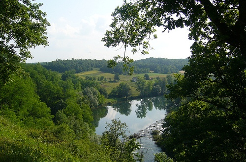
Kupa or Kolpa River is a pristine river on the border of Slovenia and Croatia. In the ancient Roman times it was known as Colapis. It takes origin in the Gorski kotar in the Risnjak National Park (in Croatia) and reaches a total length of 296 km (184 mi). It is one of the most popular places in the country for rafting. Although it is generally a slow flowing, in some parts it is forms a series of water cascades.
The Kolpa spring is about 200 m long and up to 50
m wide, a picturesque lake under the steep, forested slopes of
Risnjak near the village of Razloge in Gorski kotar , also called
Kupeško jezero. The lake is a karst spring of vokli type, in which
the divers have so far dived to a depth of -154 m. The Krašićevica
stream occasionally flows into the lake, and the underground
connection with the Malenca and Velika Voda near Crni Lug sinkholes
has been proven by painting. The spring is located inside the
Risnjak National Park and has been protected as a natural monument
since 1963. It is interesting to note that the spring is only 24 km
away from the Adriatic Sea, and the Kolpa flows almost 1500 km far
into the Black Sea.
From the source, the Kolpa River flows 5 km to the north along the
narrow wooded valley to Osilnica , where the left tributary of
Čabranka joins it, and from there it flows all the way down from the
village of Rakovec east of Metlika along the Slovenian-Croatian
state border. Due to the narrow valley and distance, the valley is
all the way to Bela krajinasparsely populated, hardly transitional
in the transverse direction, the linguistic border has been passing
through it for centuries, but it is typical that the river has
always united inhabitants from both banks and never separated. "Its
valley is, for the most part, very narrow, almost a real canyon for
some time, and is carved extremely deep everywhere. ... Its deep-cut
valley becomes more effective in relief, because it is carved into
high-lying limestone plateaus, equipped with a vast majority of
steep slopes. the slopes. "
The deep Kolpa valley is the most northerly of the great rivers of
the Dinaric mountains , which flow mostly from its heart to the
north towards the Sava River . The Kolpa also flows transversely to
the Dinaric tectonic structures, oriented from the northwest to the
southeast and constructed almost entirely of Jurassic and Cretaceous
limestones and dolomites. Only in the area of Čabranka and between
Brod na Kolpa and Kostelthere are impermeable Permian shale
siltstones and sandstones, from which many smaller streams flow into
the Kolpo, which are not found in the narrower sections of the
valley, cut through thick layers of limestone. The rock structure
also defines other characteristics of the valley: where the rocks
are impermeable to the surface, the valley is wider and the surface
is divided by streams, which is especially evident along the
Čabranka and the section between Brod na Kolpa and Kostel. just
beyond the river, just behind the road, and very steep, sometimes
steep valley slopes rise just above it. These narrowest parts are
also almost completely uninhabited.
The first such extension is at Osilnica , at the confluence of the
Kolpa and Čabranka , where the present small local center and
headquarters of the municipality were established. Soon below the
village, a river enters the narrower part of the valley, made in the
Triassic dolomites, where on the two banks of the river are small
villages, placed on the streams of short tributaries ( Ribjek ,
Bosljiva Loka , Srobotnik ob Kolpi , Kuželj on the Slovenian side
and Turks and Kuželj on the Croatian side ). High above this part of
the valley, on the Slovenian side, rise the white walls of Borovška
Gora with the picturesque Loka wall . From this part of the valley
is the story of Peter Klepec, a hero from Slovenian folk tradition.
At Brod na Kolpa (on the Slovenian side of the village of Petrina ),
a 7 km wide stretch of the valley in Permian shale sands and
sandstones begins, bearing the provincial name Kostelsko after
Kostel Castle high above the river. At the bottom of the valley and
on the slopes, there are several villages dating back to the 12th
and 13th centuries. Here is an old passage over the Kolpa valley
(the main road Kočevje-Delnice), which was also used in the 15th and
16th centuries by the Turkish armies to invade the then Carniola (
Turkish invasions ). The local center of this part of the valley is
Fara , on the Croatian side of Brod na Kolpa .
Below the village of Slavski Laz begins the next, almost 20 km long
gorge of Kolpa, which extends to the next small extension below
Stari trg near Kolpa . The valley is cut about 300 m deep into the
surrounding karst plateaus, and there is hardly room for a small
village or a lonely, abandoned mill in the valley floor. The river
flows in this part through the deep karst and receives no surface
tributaries, and is fed by several karst springs, mdr. a strong
karst spring of the Bilpa , in which the Rinža River sediments from
the Kochevskoye field come to the surface of the water .
About 200 m above the Kolpa River , on the north
side with a steep edge ends the Poljanska Valley , a former island
of Slovenian settlement in the midst of a province populated by the
Kočevars . Smaller villages are also on both banks of the Kolpa
River and near Sodevci, as well as the last bridge across the river
all the way to Bela krajina , as soon the Kolpa is again covered by
a narrow, unpopulated gorge, where there is only the river bottom
and fishing trails next to it. After this part of the valley there
is a 12 km long road from Radenci to Damel and a marked footpath.
The valley extends only slightly below Severin on the Kolpa River on
the Croatian side and at Damljeon the Slovenian side, then squeezed
again into a narrow canyon and only opened at Ucakovci in Bela
Krajina.
The landscape opens here into the wide Karlovac basin, to which the
Bela krajina belongs geologically, and slowly we enter the Pannonian
part of Slovenia. The surface here is lower and flattened, but the
Kolpa continues its stream through a narrow valley, carved into the
surrounding flattened and karst surface, which extends only slightly
at Vinica , and in the rest of it there is no space either for
settlements or for the road. It is only at Griblje that the valley
again widens into a smaller plain at the edge of which is the town
of Metlika , and slightly lower the river enters Croatia and
continues its course through the low hilly landscape of the Croatian
Pokolpje. At Ozalj , the valley widens again and the river flows in
increasing winds to the east, gets from the right Karst river Good
and flows throughKarlovac , where the Koran flows into it . It then
flows along a mostly densely populated valley between the low hills
past Petrinja to Sisak , and just below the town joins the Sava.