Location: Inner Carniola Map
Area: 38 km²
Email: info@notranjska.eu
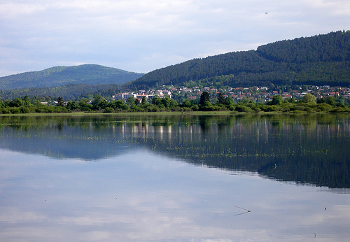
Lake Cerknica or Cerniško Jezero is a beautiful pristine lake located in the Inner Carniola region of Slovenia. The lake covers an area of 38 km² with a maximum depth of 10 meters or 33 feet. Unique feature of this body of water is a fact that it is situated over karst cavern. Occasionally the water rushes down inside underground spaces below leaving only marches and wetland above. During wet season the lake fills up again. Water shoots through numerous springs from the subterranean reservoirs below ground level. First man who described this curious pattern was ancient Greek historian, geographer and a traveler Strabo (63 BC- 24 AD. He called it Lacus Lugeus (Mourning Lake) in his book Geography (volume 7, chapter 5). However it wasn't until 17th century when Johann Weikhard von Valvasor explained these intermittent patterns. During dry periods that usually last from June to September the lake dries up leaving large expanses of lands. Locals bring their cattle here and over 200 species of migratory birds begin to nest here. The largest human settlement here is a town of Cerknica. If you want to find out more about the lake you can head to village of Dolenje Jezero (2 mi South of Cerknica) where you can visit Lake House Museum devoted to this famous lake.
Ancient Origins and Early Mentions
Lake Cerknica, located in
southwestern Slovenia within the Inner Carniola region, is one of
Europe's most remarkable karst phenomena—an intermittent lake that
periodically fills and drains due to its porous limestone bedrock.
Its history dates back to antiquity, with the earliest known
reference appearing in the works of the Roman geographer Strabo (63
BC – 21 AD). Strabo described a "marsh called Lugeon" (helos Lougeon
kaloumenon), which scholars have identified as Lake Cerknica,
romanized as Lugeum or Lugeon palus, meaning "the sad lake" possibly
due to its melancholic, fluctuating nature. This ancient
acknowledgment highlights the lake's long-standing intrigue, as its
dramatic cycles of appearance and disappearance were already noted
in classical texts. Archaeological evidence suggests the surrounding
area has been inhabited since prehistoric times, with karst
formations shaping human settlement patterns, though specific
Roman-era interactions remain sparse beyond indications of
awareness.
The lake's formation itself ties to post-glacial
geological processes. Formed after the last Ice Age, the Cerknica
Polje (a flat-floored karst valley) resulted from tectonic activity
and water erosion of limestone and dolomite, creating a network of
underground rivers, sinkholes (ponors), and estavelles (reversible
springs that can both drain and fill). This "amphibious landscape"
has influenced local ecology and human activity for millennia,
supporting diverse flora and fauna adapted to wet and dry phases.
Medieval Period: Fishing Rights and Local Economy
By the
medieval era, Lake Cerknica had become integral to regional
economies, particularly through fishing and land use. Written
records from the 10th century confirm human habitation around the
lake, with settlements like Cerknica village emerging on its
southern "island" (a raised area that becomes insular when flooded).
The first documented owners of fishing rights were the Patriarchs of
Aquileia, a powerful ecclesiastical principality in northeastern
Italy. In 1319, Patriarch Pagano della Torre granted these rights to
Oldarik Cividale for the lake and its tributaries. A century later,
around 1419, the Postojna estate acquired half the lake along with
fishing privileges.
The lake's importance grew under Habsburg
rule. In 1477, Emperor Frederick III (Cesar Friderik IV) bestowed
fishing rights upon the town of Lož, formalizing control over this
vital resource. During this period, the lake's intermittent nature
shaped local folklore and practices. When full, it spanned up to 38
square kilometers, becoming Slovenia's largest lake and a hub for
fishing; when dry, the fertile polje supported grazing, farming, and
even plowing in the same areas where boats had recently plied.
Legends of witches on nearby Slivnica Hill and enchanted valleys
arose, attributing the lake's "vanishing" to supernatural forces,
reflecting medieval interpretations of its hydrology.
From the
15th century onward, Lake Cerknica appeared on European maps,
underscoring its growing recognition beyond local borders. This
cartographic inclusion coincided with the Renaissance interest in
natural wonders, setting the stage for scientific inquiry.
Scientific Exploration in the 17th and 18th Centuries
The
Enlightenment era brought Lake Cerknica into the spotlight of
European science, as its mysterious cycles puzzled scholars. In
1687, the Carniolan polymath Johann Weikhard von Valvasor (Janez
Vajkard Valvasor) detailed the lake in a letter to London's Royal
Society, published in Philosophical Transactions. Valvasor proposed
a mechanical model inspired by Cartesian principles, explaining the
filling and emptying through underground channels. His observations,
drawn from local knowledge, noted how villagers exploited the
cycles: fishing during drainage and haymaking on the exposed bed.
Valvasor's work earned him fellowship in the Royal Society and
immortalized the lake as a "miraculous" phenomenon.
Building on
this, in 1781, Austrian mineralogist Tobias Gruber provided the
first accurate description of the lake's hydrology, emphasizing
karst processes. Three years later, in 1784, Belsazar Hacquet, a
surgeon and naturalist, refined these insights, detailing the role
of sinkholes and subterranean flows. These studies shifted
perceptions from folklore to science, portraying the lake as a
dynamic system where water from tributaries like the Stržen River
fills the polje in wet seasons (autumn-winter), reaching depths of
up to 10 meters, only to drain via ponors in drier periods,
transforming into a lush meadow teeming with wildlife. The lake's
biodiversity—home to rare birds, amphibians, and plants—further
fueled interest, with botanists noting amphibious species adapted to
its dual states.
19th and 20th Centuries: Human Interventions
and Conflicts
The industrial age saw attempts to tame the lake's
unpredictability. Flooding posed risks to agriculture, prompting
drainage efforts. In the 19th century, various proposals emerged,
but significant action began in the early 20th century. In 1921, a
water company was established in Cerknica with the goal of permanent
drainage. Led by engineer Hočevar until World War II, the project
involved deepening channels and sinkholes to accelerate outflow,
aiming to reclaim land for farming. These interventions altered the
lake's natural rhythm, though never fully eliminating its
intermittency.
Post-WWII, under Yugoslav Slovenia, the lake's
ecological value gained recognition. Conflicts arose between
drainage advocates and conservationists, reflecting broader tensions
between development and nature. By the late 20th century, awareness
of its unique ecosystem—supporting over 200 bird species and serving
as a key wetland—led to protective measures. In 2006, it became part
of the Notranjska Regional Park, emphasizing sustainable tourism and
research.
Contemporary Status and Cultural Legacy
Today,
Lake Cerknica is celebrated as a UNESCO tentative World Heritage
site under "Classical Karst," illustrating ongoing geomorphological
processes. It attracts visitors for activities like cycling,
birdwatching, and exploring sinkholes, while festivals honor its
folklore, including witch legends. Climate change poses new
challenges, potentially altering filling cycles, but ongoing studies
build on centuries of observation. The lake's history encapsulates
humanity's evolving relationship with nature—from ancient awe and
medieval exploitation to scientific understanding and modern
conservation—making it a timeless symbol of Slovenia's karst
heritage.
Location and Physical Characteristics
The lake lies in the
southern portion of the Cerknica Polje, a karst polje within the Inner
Carniola region, approximately 35 km south-southwest of Ljubljana,
Slovenia's capital. Its central coordinates are roughly 45°45′N 14°23′E,
and it is oriented in a northwest-to-southeast direction, aligning with
the structural trends of the Dinaric Alps. At an elevation of about 550
meters above sea level (ranging from 546 to 553 meters depending on
water levels), the lake's surface area varies dramatically. When full,
it can cover up to 38 km², though it typically spans 20-26 km², with
lengths around 10.5 km and widths up to 5 km. The maximum depth reaches
about 10 meters. This makes it larger than Slovenia's permanent lakes,
such as Lake Bohinj, by a factor of nearly eight when at its peak.
The Cerknica Polje itself is a tectonic depression, forming a flat plain
that serves as the lake's basin. The lake's intermittent nature means it
is present for approximately eight to nine months of the year, typically
from autumn through spring, before draining in the drier summer months.
Geology and Karst Features
Lake Cerknica exemplifies classic
karst topography, a landscape shaped by the dissolution of soluble rocks
like limestone. The polje floor is underlain by impermeable dolomite in
its northern section and more soluble Cretaceous limestone in the
southeast, covered by alluvial deposits of loam, clay, and sand up to 10
meters thick. This geological setup creates a network of underground
caves, rivers, and sinkholes (known as ponors) that allow water to
infiltrate rapidly.
The lake's basin is part of the broader Slovenian
Karst region, where surface water connects directly to the groundwater
table. Sinkholes and craters become visible when the lake drains,
revealing a "moon-like" landscape of karst features. The polje's
formation is tectonic, resulting from faulting and subsidence in the
Dinaric Alps, which has produced a flat, enclosed depression prone to
flooding.
Hydrology and Water Dynamics
The hydrology of Lake
Cerknica is driven by its extensive catchment area of about 475 km²,
including inflows from the Bloke Plateau, eastern Snežnik Hills,
Javorniki, Loška Dolina, and Slivnica. Major tributaries contribute
water at rates up to 240 cubic meters per second during heavy rainfall,
while outflows range from 40 to 90 cubic meters per second through
underground channels. This imbalance causes the lake to fill
quickly—often within two to three days after intense precipitation—and
drain just as rapidly when inflows decrease.
Water enters primarily
through surface streams and springs, but excess drains via ponors into
the subterranean karst system, eventually resurfacing elsewhere, such as
in the Ljubljanica River basin. The lake's water level can fluctuate by
over 7 meters, leading to its complete disappearance in dry periods,
transforming the area into a grassy meadow. This cycle is influenced by
seasonal precipitation patterns, with filling most common in the wetter
months and emptying in summer.
Surrounding Landscape and
Topography
The lake is encircled by dramatic alpine features. To the
south and southwest rise the Javornik Hills, part of the Dinaric Alps,
reaching elevations of 1,268 meters at Veliki Javornik. To the north
looms Mount Slivnica, peaking at 1,022-1,114 meters, providing a natural
barrier. The Bloke Plateau borders it to the east, contributing to the
catchment.
These surrounding highlands not only frame the polje but
also influence local microclimates and water flow. The area transitions
from the lake/polje floor to forested hills, creating diverse habitats.
When dry, the plain reveals sinkholes, craters, and underground
entrances, while when flooded, it supports aquatic ecosystems.
Ecological and Human Geography
Geographically, Lake Cerknica is a
biodiversity hotspot, designated as a Ramsar wetland site since 2006 for
its international importance. The fluctuating water levels support
varied ecosystems: wetlands and reeds when full, meadows with
wildflowers and butterflies when dry. It hosts abundant birdlife, fish,
and other wildlife, making it a key site for conservation.
Human
interactions include recreational activities like cycling around its 26
km² perimeter (starting from villages like Dolnje Jezero), fishing, and
hiking. Historically, the lake supplied ice to distant places like India
in the 19th century, though recent climate changes have led to shorter
flooding periods and water shortages. The nearby town of Cerknica serves
as a gateway, with the lake integrated into the Notranjski Regional Park
for protection and tourism.