Location: Inner Carniola Map
Tel. +386 1 70 71 464, +386 41 693 124
Email: h.rakovskocjan@gmail.com
Official site
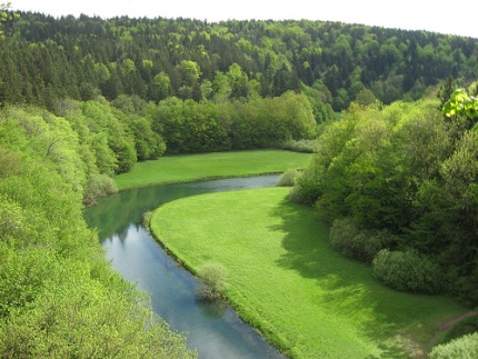
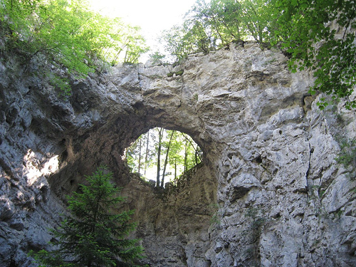
Rakov Škocjan is a picturesque valley situated 5 km West of Cerknica in Inner Carniola region of Slovenia. Rakov Škocjan was formed by a Rak River, a tributary of Pivka River. It formed two magnificent bridges. One is called Little Natural Bridge (Mali Naravni Most), while another larger Great Natural Bridge (Veliki Naravni Most) is situated within a hiking distance down stream from a village of Rakov Škocjan. This landscape park was designated in 1949. Archaeological digs here revealed that prehistoric men settled area around natural bridges to seek protection from the elements. Other artifacts also date back to Roman and Medieval times. You can get here from the Rakek train station and just get here by foot. Don't try to climb these geological formations. Limestone is fairly unstable in places due to centuries of erosion.
Geological Formation and Prehistoric Origins
Rakov Škocjan,
located in southwestern Slovenia near the settlement of the same
name in the municipality of Cerknica, is a stunning karst valley
formed through millions of years of geological processes. This
landscape emerged from an enormous underground cave system in the
Karst region, characterized by soluble limestone bedrock that erodes
over time due to rainwater's corrosive action, creating ravines,
tunnels, and caves. Approximately 3 million years ago, the cave's
roof collapsed, leaving behind a 3 km-long open valley with dramatic
features like sheer cliffs up to 300 meters high and two massive
natural stone arches: the Little Natural Bridge (Mali naravni most,
about 42 meters high) at the eastern end and the Big Natural Bridge
(Veliki naravni most, about 37 meters high) at the western end.
These bridges are remnants of the original cave ceiling, formed as
floodwaters eroded the structure from below, causing periodic
collapses.
The valley's floor is a flat clay bottom with reeds
and floodplain meadows, through which the Rak River (also called the
Rak stream or "River of 7 Names" due to its multiple underground
resurgences and name changes) flows. The river enters from the
Zelške Caves (Prince Ugo caves) on the eastern side, fed by
underground waters from the Cerknica Field and Javorniki hills, and
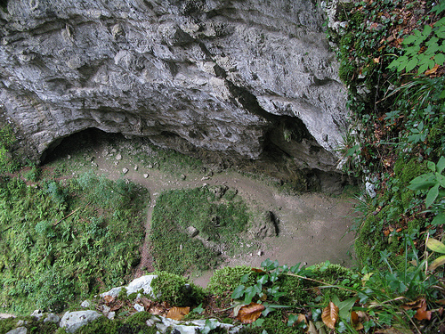
disappears into the Tkalca Cave (Weaver's Cave) on the western side,
named for a stalagmite resembling a human figure at a loom. From
there, it continues subterranean through the Planina Cave and
Confluence Cave, eventually merging with the Pivka River to form the
Unica River. The site's karst phenomena, including gorges,
sinkholes, and disappearing waters, exemplify the "Classical Karst"
region, where such features were first scientifically studied.
Name Origin and Etymology
The name "Rakov Škocjan" is a
relatively modern construct, literally translating to "Škocjan on
the Rak" or "Valley of the Rak." "Rak" refers to the river flowing
through it, which also means "crayfish" in Slovenian, possibly
alluding to the aquatic life in the stream. The "Škocjan" component
is a contraction of "šent Kǫcьjanъ," honoring Saint Cantianus (Sv.
Kancijan), the patron saint of the local church. This etymology is
shared with other Slovenian sites named Škocjan, but it
distinguishes this valley from the nearby UNESCO-listed Škocjan
Caves.
The name was artificially coined in the mid-20th century.
In 1949, when the area was first protected, it was initially
proposed as "Rakovska kotlina" (Rak Basin). "Rakov Škocjan" first
appeared in the mid-1960s and gained widespread use by the 1980s,
replacing alternatives like "Rakova dolina" (Rak Valley) or "Dolina
Raka" (Valley of the Rak). It has also been called the "Valley of
San Škocjan" due to the saint's church.
Human History,
Archaeology, and Settlements
Human interaction with Rakov Škocjan
dates back to prehistoric times. The site is an important Iron Age
archaeological location, with findings indicating ancient human
activity, though specific details on settlements remain sparse. The
most prominent historical remnant is the ruins of the Church of St.
Cantianus (Cerkvica Sv. Kancijana), perched above the Big Natural
Bridge. Constructed in the early 17th century in the late Gothic or
Neo-Gothic style, only fragments of the facade, walls, and
foundation survive today. This church likely served local
communities in the surrounding karst landscape, and its location
atop the bridge suggests it may have held symbolic or strategic
importance.
Prior to modern protection, the land was historically
owned by the Prince of Windischgrätz, a noble figure in the
Austro-Hungarian Empire, indicating its integration into regional
estates. No extensive settlements are documented, but the church and
Iron Age artifacts point to sporadic human presence, possibly for
religious, agricultural, or shelter purposes in this rugged terrain.
Exploration and Early Documentation
Early exploration of
Rakov Škocjan is tied to broader interest in Slovenia's karst
wonders. The 17th-century Slovenian polymath Johann Weikhard von
Valvasor (Janez Vajkard Valvasor) documented the valley in his
seminal work Die Ehre des Herzogthums Krain (The Glory of the Duchy
of Carniola, 1689), describing its mesmerizing features and noting
how local farmers and peasants mistook stalagmites in the caves for
animals, humans, or divinities. This marks one of the earliest
written accounts, highlighting the site's allure to scholars and
locals alike.
Systematic scientific exploration paralleled
developments in nearby sites like the Škocjan Caves, but Rakov
Škocjan's open valley allowed easier access. By the 19th and 20th
centuries, it attracted naturalists studying karst geology. Today,
exploration is facilitated by a 3 km natural history trail with
well-maintained footpaths, wooden markers, and zig-zag stone steps
leading to hidden valleys and mini-caves. Visitors can hike under
the arches, view seasonal river levels (sometimes allowing
swimming), and observe the Weaver's Cave from protected paths, with
a full loop taking 4-5 hours.
Modern History, Conflicts, and
Protection
In the 20th century, Rakov Škocjan became a site of
historical conflict during World War II. On October 20, 1944, the
Yugoslav Partisan brigade "Vladimir Gortan," aligned with Josip Broz
Tito, clashed with a German Wehrmacht division, supported by Chetnik
forces loyal to General Draža Mihailović and King Peter II of
Yugoslavia. This battle reflects the broader partisan resistance in
Slovenia against Axis occupation and royalist factions.
Post-war,
the valley's natural significance led to its protection. It was
designated a landscape park by Decree No. 595 on August 29, 1949,
published in the Official Journal of the Republic of Slovenia on
September 6, 1949, during the early years of socialist Yugoslavia.
This made it Slovenia's oldest landscape park, established by the
Tourist Institutions of the socialist republic as a protected nature
reserve. It is now part of the Inner Carniola Regional Park and,
along with Lake Cerknica and Križna Cave, recognized as a Ramsar
wetland of international importance. The site has been nominated for
UNESCO World Heritage status due to its exemplary karst features.
Protection emphasizes preserving the natural jungle-like vegetation,
centuries-old oaks, and unspoiled ecosystem, with restrictions on
vehicle access to maintain its pristine state.
Rakov Škocjan is a stunning karst valley and landscape park located
in southwestern Slovenia, within the Inner Carniola region. It forms
part of the Notranjski Regional Park and has been protected since
1949, making it the oldest landscape park in the country.
Administratively, it belongs to the settlement of Rakov Škocjan in
the Municipality of Cerknica, and its coordinates are approximately
45°47′9.14″N 14°17′56.58″E. The valley is renowned for its dramatic
karst topography, which includes collapsed caves, natural bridges,
and underground river systems, offering a prime example of
Slovenia's unique limestone landscapes.
Location and Physical
Dimensions
Geographically, Rakov Škocjan is situated at the
northern foot of the Javorniki hills, positioned between the
Cerknica Plain to the east and the Planina Plain to the west. The
valley itself stretches about 2.5 km in length and reaches up to 500
m in width, forming a relatively narrow, elongated depression in the
landscape. It is enclosed on all sides by sheer limestone cliffs
that can rise as high as 300 m, creating a dramatic, gorge-like
enclosure that isolates the valley floor from the surrounding
plateau. This plateau is largely barren and forested, typical of
karst terrain where surface water is scarce due to rapid drainage
into underground systems. The area is about 6 km west of Cerknica
and lies within a broader karst region characterized by intermittent
lakes, sinkholes, and subterranean hydrology.
Geological
Formation and Karst Features
The valley's formation dates back
approximately 3 million years, resulting from the collapse of a
massive karst cave ceiling, which left behind an open valley with
remnant structures like natural stone arches. Karst landscapes,
named after Slovenia's own Kras region, are defined by soluble
limestone bedrock eroded by water, leading to features such as
caves, sinkholes, springs, and underground rivers. In Rakov Škocjan,
this process has created a "green karst jungle" with thick forests,
rocky outcrops, and a network of water and dry caves. The site
includes spectacular gorges, deep sinkholes, and cliffs, with the
valley floor being relatively flat and traversed by a river. It
exemplifies dynamic karst processes, where surface and subsurface
erosion continue to shape the terrain, particularly at the river's
entry and exit points.
Key karst phenomena include over 6 km of
interconnected cave systems, with collapsed sections forming natural
bridges and exposed gorges. The area is dotted with sinks, springs,
and sinkholes, contributing to its hydrological complexity. The
surrounding limestone plateau lacks permanent surface water, as
rainfall quickly percolates underground, feeding the intermittent
streams below.
The Rak River and Hydrology
Central to the
valley's geography is the Rak River (or Rak Creek), a short stream
approximately 2 km long that originates from underground waters
emerging at the Zelške Caves on the eastern end. Fed by waters from
the nearby Cerknica Plain and Javorniki hills, it flows above ground
through the valley for about 3.5 km before disappearing into
Weaver's Cave (Tkalca Jama) at the western side. The river then
travels underground through a 400 m narrow tunnel, eventually
reemerging in Planina Cave and joining the Pivka River. This
intermittent flow is characteristic of karst hydrology: the Rak
often dries out on the surface during warmer months but runs high in
autumn, winter, or after heavy rains, sometimes submerging paths and
transforming the valley. The river has sculpted the landscape,
deepening gorges and contributing to cave collapses, making the area
a paradise for exploring romantic countrysides and natural
formations.
Key Landmarks and Human Elements
The valley
boasts two iconic natural bridges formed by the cave collapse: the
Little Natural Bridge (Mali Naravni Most) at the eastern end, near
the river's spring, and the Big Natural Bridge (Veliki Naravni Most)
about 2.5 km downstream to the west. These massive stone arches are
remnants of the original cave roof and serve as dramatic gateways to
the valley. Nearby, the ruins of St. Cantianus's Church, built in
the early 17th century in late Gothic style, stand above the valley
near the Big Natural Bridge; this site also holds Iron Age
archaeological significance.
Other notable features include the
Weaver's Cave and Zelške Caves, which bookend the surface flow of
the Rak, as well as various hiking trails that weave through forests
and along the riverbed. The valley's steep, sunny rocks and deep
caves create microhabitats supporting diverse flora, such as
vegetation adapted to cool, moist cave climates near the springs.
Fauna includes species thriving in this mix of forests, cliffs, and
subterranean environments, though specific details on wildlife are
more anecdotal in sources.
Environmental and Seasonal
Variations
Rakov Škocjan's geography is dynamic, influenced by
seasonal water levels. In winter, the valley can transform into a
snowy wonderland with frozen features, enhancing its karst drama.
The dense forest cover, including hundred-year-old oaks and pines,
creates a lush, jungle-like atmosphere, contrasting with the barren
karst plateau above. This biodiversity hotspot combines habitats
like deep caves, moist springs, and sunny cliffs, fostering unique
ecological niches. Overall, the site's protection emphasizes its
role as a geological treasure, ideal for hiking and nature
observation while preserving its fragile karst ecosystem.