about it poured a drink-offering to all the dead,
first with mead and thereafter with sweet wine,
and for the third time with water, and I sprinkled white meal
thereon (…),
I took the sheep and cut their throats over the trench,
and the dark blood flowed forth, and lo,
the spirits of the dead that be departed gathered them from out
of Erebus (…),
then did I speak to my company and command them
to flay the sheep which even now lie slain by the pitiless
sword,
and to consume them with fire, and to make prayer to the gods,
to mighty Hades and to dread Persephone.
(The Odyssey, Book XI)
Location: Karst Plateau Map
Average Temperature: 12 °C
Open: throughout a year
Contact Information:
Tel. +386 (0)5 70 82 100
Fax: +386 (0)5 70 82 105
Email: psj.info@psj.gov.si
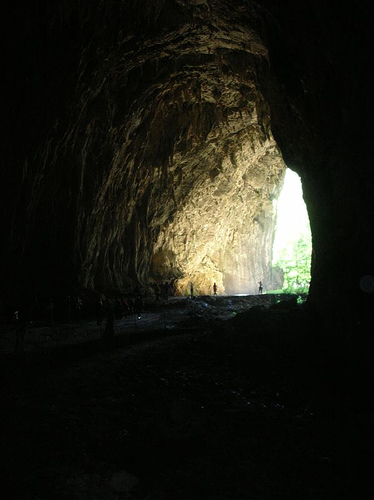
The Škocjan Caves, located in the Kras Plateau of southwestern Slovenia, represent one of the world's most outstanding examples of karst landscapes. This limestone cave system spans a protected area of 413 hectares and features dramatic underground canyons, collapsed dolines (sinkholes), waterfalls, and vast chambers sculpted by the Reka River over millions of years. Recognized for its exceptional natural beauty and scientific value, the site was inscribed as a UNESCO World Heritage Site in 1986 under criteria (vii) and (viii), highlighting its aesthetic significance and role in understanding karst processes. It is also designated as a Ramsar Underground Wetland since 1999 and a UNESCO Man and the Biosphere (MAB) Reserve since 2004, underscoring its global importance for biodiversity and ecosystem conservation. The caves are part of the Classical Karst region, which gave the name "karst" to similar geological formations worldwide.
Geologically, the Škocjan Caves formed in a thick layer of Cretaceous
and Paleocene limestone, at the contact zone between impermeable Eocene
flysch rocks and permeable limestone, creating a classic example of
contact karst. The Reka River, originating from the Snežnik Plateau,
flows approximately 55 km on the surface before sinking underground at
the caves, carving out an extensive network over several million years.
The system includes about 6.2 km of explored passages, with a total
depth of 223 meters from the surface to the lowest point, and elevations
reaching up to 435 meters at viewpoints like the Crown Princess
Stephanie. Key features include the massive underground canyon—Europe's
largest, averaging 20-30 meters wide and 30-110 meters high—along with
cascades, lakes, and the Martel Chamber, which boasts a volume of 2.55
million cubic meters.
The formation process involves the river's
erosive power, leading to collapsed dolines such as Velika dolina (163
meters deep) and Mala dolina, separated by natural bridges. Upper-level
passages reveal evolutionary stages of the cave network, with
speleothems (stalactites, stalagmites, and flowstone) adorning halls
like the Paradise (flowstone deposits), Organ Hall (organ-like
formations), Great Hall (giant stalagmites), and Rimstone Pools' Hall
(large rimstone pools). The river's flow averages 8.2 m³/s but can surge
to 387 m³/s during floods, disappearing into a sump beyond the Martel
Chamber and reemerging 35 km away as the Timavo River in Italy.
Prehistoric and Ancient Occupation
The Škocjan Caves, located in
southwestern Slovenia within the Karst Plateau, have a rich history of
human interaction dating back over 10,000 years. Archaeological evidence
reveals that the area served as a site for human settlements from the
Mesolithic period through the Neolithic, Bronze Age, and Iron Age.
During the Iron Age, a fortified settlement was constructed near the
present-day village of Škocjan, highlighting the caves' strategic
importance. The Romans later established a military outpost in the same
location, and by the Middle Ages, a fortified rural settlement had
developed. The caves and surrounding dolines (collapsed sinkholes) were
not only used for habitation but also as burial grounds and ritual
sites. Excavations have uncovered burial sites containing skeletons,
pottery, and funerary goods, suggesting ceremonial practices. For
instance, one chamber yielded 10 skeletons along with offerings,
indicating reverence for the site as a place of worship and ritual.
These findings underscore the caves' role in prehistoric spiritual and
communal life, with the dramatic underground landscape likely inspiring
awe and mythological significance.
The earliest written references to
the Škocjan Caves appear in antiquity, with the Greek philosopher
Posidonius of Apamea documenting the underground phenomena in the 2nd
century B.C. This marks the caves as one of the oldest recorded karst
features in Europe. By the 16th and 17th centuries, the site gained
cartographic recognition, appearing on early maps such as the
Lazius-Ortelius map of 1561 and Mercator's Novus Atlas of 1637, which
depicted the Reka River's sink into the limestone bedrock.
Geological Formation and Early Modern Recognition
Geologically, the
Škocjan Caves formed over approximately 5 million years through the
erosive action of the Reka River, which originates from the Snežnik
Plateau and descends into the permeable Cretaceous limestone of the
Karst region. This process created a 6 km-long system of underground
passages, including massive chambers like the Martel Chamber (with a
volume of 2.5 million cubic meters) and the world's largest known
underground canyon, reaching depths of over 200 meters and heights up to
146 meters. The caves exemplify "contact karst," where the river
transitions from impermeable flysch rock to soluble limestone, resulting
in dramatic features like waterfalls, cascades, and speleothems
(stalactites and stalagmites). Sediments deposited by the river preserve
a detailed record of this evolutionary history, including evidence of
massive floods that can raise water levels by up to 130 meters.
In
the late 17th century, the Carniolan polymath Johann Weikhard von
Valvasor provided one of the first scientific descriptions in 1689,
detailing the Reka River's subterranean flow and the caves' deep shafts.
This laid the groundwork for viewing the site as a hydrological marvel,
particularly amid efforts to harness underground water sources in the
region.
By the 18th century, the caves' aesthetic and natural allure
drew artistic attention. In 1782, the French painter Louis-François
Cassas was commissioned to create landscape illustrations of the Big
Collapse Doline (Velika Dolina), capturing visitors descending into the
abyss. These works emphasized the caves' significance as a prominent
natural feature in the Trieste hinterland, blending romanticism with
early tourism.
19th Century: Systematic Exploration and Tourism
The 19th century marked the transition from anecdotal observation to
systematic scientific inquiry, establishing Škocjan as a cornerstone of
karstology and speleology. Tourism began modestly around 1819 when a
local county councilor ordered the construction of steps into the caves,
making them accessible to visitors and arranging the site as one of
Europe's earliest show caves.
Exploration intensified in 1839 when
Jakob Svetina descended 100 meters along the Reka River. Speleological
research formally commenced in 1851, driven by the need to understand
the underground hydrology. A major expedition in 1884, led by local
explorers, pushed deeper into the system. By 1890, they reached the
banks of Mrtvo jezero (Dead Lake), a significant milestone. The renowned
French speleologist Édouard-Alfred Martel visited in 1893 and 1894,
documenting his findings in his book Les Abîmes, which popularized the
caves internationally and solidified their status as a premier karst
site.
Infrastructure expanded with over 12 kilometers of ferrata
paths (secured climbing routes) along steep walls, some 50 meters above
the river, facilitating safer access. These developments transformed
Škocjan into a hub for scientific study and adventure, with explorers
navigating vertigo-inducing bridges like the Cerkvenik Bridge over the
underground canyon.
20th Century: Discoveries, Protection, and
Global Recognition
The early 20th century brought breakthroughs,
including the 1904 discovery of Tiha jama (Silent Cave) by local
explorers who scaled a 60-meter wall in Müller Hall. This revealed
upper-level passages that provided insights into the cave's multi-stage
development.
Post-World War II, the caves continued to attract
researchers, with ongoing studies into microclimates, particulate
matter, and biodiversity, including rare species like the endemic olm (a
cave salamander) and various lepidoptera. The site's ecological value,
combined with its geological uniqueness, led to its inscription as a
UNESCO World Heritage Site in 1986—the first in Slovenia—recognizing it
as an exceptional karst system and a cradle of karst science.
Following Slovenia's independence from Yugoslavia in 1991, the
government committed to preservation, establishing the Škocjan Caves
Regional Park to manage tourism, research, and conservation. This
included monitoring floods, protecting habitats, and integrating
archaeological findings into site management.
Modern Era and
Ongoing Legacy
As of 2026, the Škocjan Caves remain a vital site for
scientific research, with studies on cave evolution, climate impacts,
and biodiversity continuing. The caves are often called the "Underground
Grand Canyon" or the birthplace of modern speleology, drawing over
100,000 visitors annually while emphasizing sustainable tourism. Recent
archaeological work has uncovered more details about prehistoric
rituals, and environmental monitoring ensures the preservation of this 6
km labyrinth amid climate change threats like altered flood patterns.
The site's integration of natural, cultural, and scientific heritage
makes it a timeless testament to human curiosity and nature's power.
The Škocjan Caves host a remarkably diverse ecosystem, particularly
in its subterranean environments, which support unique species adapted
to darkness and humidity (80-100%). The underground habitats are home to
troglobiotic (cave-dwelling) invertebrates and the olm (Proteus
anguinus), Europe's only troglobiotic vertebrate, often called the
"human fish" for its pale skin and aquatic lifestyle. Caves also serve
as roosts for several bat species, contributing to the site's inclusion
in Natura 2000 protected areas.
On the surface, the collapsed dolines
create microhabitats with inverted vegetation patterns—sub-Mediterranean
flora thrives in depressions due to cooler, moister conditions, while
rocky plateaus are sparsely vegetated. The park encompasses various
habitat types: woodlands (277 ha), dry grasslands (52 ha), inland rocks
(13 ha), and more, supporting endemic species and EU-priority habitats.
Ecosystem services include water regulation, biodiversity conservation,
and cultural values, with the area vulnerable to climate changes and
human impacts like pollution from the Reka River's catchment.
Tourism at Škocjan Caves is carefully managed to minimize environmental impact, with guided tours available year-round (except in extreme weather). The classic underground route covers about 3 km, taking 1.5-2 hours, and includes crossing the iconic Cerkvenik Bridge, 45 meters above the river. Surface trails offer views from viewpoints like Miklov skedenj, overlooking the dolines and river sinkhole. The park attracts around 100,000 visitors annually, with facilities including an educational center, museum, and accommodations in nearby villages like Škocjan and Matavun. Sustainable practices emphasize low-impact access, monitoring of air and water quality, and integration with local communities for economic benefits.
The caves' underground wetland status makes them one of the few such
sites globally, vital for studying subterranean hydrology.
With 54
designated natural features (geological, hydrological, and biological),
the park is a hotspot for research in karst science.
The area's
sub-Mediterranean climate, influenced by strong bora winds, creates
unique microclimates that enhance biodiversity.
As part of the
broader Karst Plateau, Škocjan Caves connect to other systems, forming a
transboundary hydrological network extending into Italy.