Locaton: Öland Map
Eketorp Fort, often referred to as Eketorp Castle or Eketorps borg, is a reconstructed Iron Age ringfort located in southeastern Öland, Sweden, near the town of Degerhamn in Kalmar County. Situated at coordinates 56°17′44″N 16°29′10″E, it is one of 19 prehistoric fortifications on the island of Öland, which is part of a UNESCO World Heritage Site recognized for its unique cultural landscape. Originally built around 400 AD as a defensive structure during the Nordic Iron Age, the fort has undergone multiple phases of use and abandonment, with significant reconstruction in the Middle Ages and modern times. Today, it stands as Sweden's only fully excavated and reconstructed ancient ringfort, serving as an open-air museum that brings prehistoric and medieval life to vivid reality through immersive exhibits, re-enactments, and hands-on activities. The site attracts nearly 39,000 visitors annually (as of 2019 data), offering a unique blend of archaeology, history, and family-friendly education in a flat, open landscape typical of Öland's limestone plains. Managed by the municipality of Mörbylånga since 2019, Eketorp is celebrated for its role in experimental archaeology and as a window into Sweden's ancient past.
Eketorp (also known as Eketorps borg or Eketorp Castle) is a
remarkable Iron Age ring fort (fornborg) located in southeastern
Öland, Sweden, on the island’s characteristic alvar (a flat
limestone plain). It stands as one of roughly 15–19 known
prehistoric ring forts on Öland, but it is uniquely significant: the
only one to have been completely excavated and extensively
reconstructed as a living-history open-air museum.
The site’s
circular dry-stone walls, rebuilt houses, and central well allow
visitors to step directly into over 1,500 years of layered
occupation—from a temporary Iron Age refuge and sacred gathering
place to a permanent fortified farming village and, finally, a
medieval cavalry garrison. Its history reflects broader patterns on
Öland: prosperity and Roman-era contacts in the Migration Period,
possible periods of conflict and abandonment, and later medieval
power struggles tied to the formation of the Swedish kingdom.
Early Construction and Eketorp I (c. AD 300–400/500)
Eketorp’s story begins in the Scandinavian Iron Age (Migration
Period), around the early 4th century AD (some sources pinpoint c.
AD 300). Indigenous farming communities—likely about 20
households—built the original fortification during a time of
relative prosperity on Öland, when the island’s inhabitants had
growing contacts with the Roman Empire and other European peoples.
The first structure, Eketorp I, was a smaller circular ring fort
roughly 57 meters (187 ft) in diameter, constructed of dry-stone
walls (no mortar) using locally abundant limestone. Its circular
design was deliberate: on the level alvar terrain, an attack could
come from any direction, so a round layout offered equal defensive
potential. The fort stood near a wetland or small lake that had
served as a sacrificial site since around the birth of Christ;
archaeologists found horse bones (horses were sacred animals linked
to gods of war and fertility) and other animal remains, along with
hazel sticks marking sacred springs.
Inside, about 20 simple
stone shelters or “cells” lined the inner face of the curtain wall,
with openings facing the central open area. Few had fireplaces, and
artifact density was low, suggesting the fort was not permanently
inhabited but used occasionally—as a communal refuge during unrest
and a gathering place for religious ceremonies or seasonal rituals.
The entire southern Öland agricultural landscape is now part of a
UNESCO World Heritage Site, underscoring the long-term human
adaptation to this environment.
Expansion into a Permanent
Village: Eketorp II (c. AD 400/500–650/700)
By the early 5th
century, the community outgrew the original fort. Builders
dismantled Eketorp I and reused its stones to expand outward,
creating Eketorp II—a much larger circular fort approximately 80
meters (260 ft) in diameter (roughly doubling the enclosed area).
This phase lasted about 250–300 years and marked a shift to
year-round occupation as a fortified peasant hamlet.
The new
layout featured:
Three main gates (southwest, northeast, and
a small postern gate to the east leading to the water source).
Roughly 53 stone-built structures inside: 22 dwellings, 12
storehouses, 12 byres (animal barns), and at least one iron forge.
Houses with limestone walls and turf roofs, each containing a
central hearth for heating and cooking. Some lined the inner wall;
others formed an irregular central quarter.
An estimated
150–200 people (perhaps 20–30 households of about 7 members each)
lived here alongside livestock—cows, sheep, goats, horses, pigs,
cats, dogs, hens, and geese. Finds reveal a self-sufficient agrarian
community engaged in animal husbandry, ironworking, crafts, and some
trade. Artifacts include tools, jewelry, weapons, large quantities
of animal bones, and Roman gold solidi coins—likely payment to
Ölandic warriors who served as mercenaries in Roman or
Hunno-Ostrogothic armies. A unique feature at the north gate
(grooves for a sliding iron portcullis) shows direct Roman
technological influence transferred to northern Europe.
In the
western part of the fort, archaeologists identified a possible
assembly or ritual area with stones that may have supported a god
statue; thin gold-foil figures (guldgubbar) depicting men and women
were also recovered. The fort served both defensive and social
functions, acting as a refuge for the wider agricultural community
while functioning as a fully inhabited village.
Eketorp II was
abandoned sometime in the mid-7th century (around AD 650–700). The
reasons remain unclear but may relate to a period of relative peace
on Öland, allowing people to disperse to individual farmsteads. The
nearby lake continued to be used for sacrifices until around AD
1000.
Abandonment, Reoccupation, and Medieval Use: Eketorp
III (c. 11th–13th centuries, mainly AD 1170–1240)
After roughly
500 years as ruins, Eketorp saw renewed activity in the late Viking
Age or early Middle Ages (some sources note reoccupation around AD
1000–1100, but the main garrison phase is dated c. 1170–1240). This
Eketorp III phase transformed the site into a military installation
during the turbulent consolidation of the Swedish kingdom. Rival
powerful families (including the Sverker and Erik dynasties) fought
for control of Öland, which commanded key sailing routes and rich
herring fisheries.
Defenses were repaired and strengthened:
The original ring wall was reinforced.
A low outer defensive wall
was added.
Timber-framed houses (a shift from earlier stone
construction) were built with gables against the inner wall, facing
a central open area with stone-paved streets radiating from a
square.
A large central kitchen (with a single large hearth) fed
the garrison; forges for weapons and boat rivets were placed between
the inner and outer walls to reduce fire risk.
At its peak, the
site contained over 100 buildings, including stables and lodging for
soldiers and their families (women and children were present).
Artifacts from this phase are distinctly military: spears,
swords, shields, arrows, caltrops (spiked traps), and horse
equipment (some ornate). Evidence of attacks includes burned layers
at the south gate. The fort functioned as both a cavalry garrison
and a safe haven. It was likely abandoned around AD 1240 after the
Sverker family secured the throne; one theory links the final
emptying of the garrison to King Johan Sverkersson’s crusade to Ösel
(Estonia) in 1220, after which few soldiers returned.
Modern
Rediscovery: Excavation, Reconstruction, and Tourism (20th–21st
centuries)
Eketorp lay largely forgotten until the mid-20th
century. Between 1964 and 1974 (some sources say 1964–1973), the
Swedish National Heritage Board conducted a full excavation—the only
complete one among Öland’s ring forts. The team recovered more than
24,000–26,000 individual artifacts and three tons of animal bones,
revealing the three distinct settlement layers stacked on top of one
another.
Beginning in 1978, the fort was reconstructed directly
on the original foundations, primarily reflecting the Eketorp II
Iron Age village layout (with some medieval elements preserved or
reinterpreted). This made Eketorp Sweden’s first major site
combining archaeological reconstruction, experimental archaeology,
and public education. Today it operates as a living-history museum:
staff in period costumes (focused on the 400–650 AD era) demonstrate
crafts, archery, bread baking, and daily life. A small museum in the
longhouses displays selected artifacts. Special exhibitions have
included reconstructions of Iron Age horse sacrifices (based on the
lake finds), though one 2005 display sparked brief controversy over
realism.
Since 2019, the municipality of Mörbylånga has managed
the site. It remains a popular tourist destination, drawing nearly
39,000 visitors in its first season under municipal oversight and
hosting re-enactments, guided tours, and seasonal events. The well
in the center—mentioned by Carl Linnaeus in 1741—still provides
water, tying the present directly to the distant past.
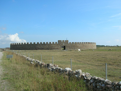
Eketorp (Eketorps borg) is a remarkable prehistoric ring fort
(fornborg) on the flat plains of southern Öland, Sweden, rather than a
traditional medieval castle. It is the only one of Öland’s 19 known Iron
Age ring forts to have been fully excavated (1964–1974) and
authentically reconstructed as an open-air museum. The site showcases
defensive architecture, domestic buildings, and community layout across
three distinct phases from the 4th century AD to the 13th century.
The fort’s circular design was deliberate: on level terrain, attacks
could come from any direction, so a ring shape provided equal defensive
coverage and maximized interior space. Local limestone was the primary
building material throughout, supplemented by wood and thatch. The
reconstructed site primarily represents Eketorp II (the most substantial
phase) while incorporating elements of the later medieval reuse.
Phases of Construction and Architectural Evolution
Eketorp I (c.
300–400/500 AD): The earliest phase was a smaller circular stone
fortification with a diameter of about 57 meters (187 ft). Roughly 20–23
houses lined the inner face of the curtain wall, opening toward a
central open space. It served mainly as a temporary refuge for nearby
farming communities and a site for religious ceremonies and gatherings
(possibly including animal sacrifices near an adjacent wetland). The
layout was simple and communal, with minimal permanent occupation.
Eketorp II (c. 400/500–650/700 AD): This is the best-documented and most
fully reconstructed phase. The original wall stones were relocated
outward to create a much larger circular enclosure of approximately 80
meters (260 ft) in diameter—roughly doubling the fortified area. About
50–53 stone structures filled the interior:
~22–23 dwellings
(residential houses) with central hearths, slab thresholds, and numerous
artifacts indicating daily life.
~12 byres (animal barns) featuring
stall partitions along the walls and fewer finds.
~12 storehouses
with raised slab floors for dry storage.
Additional workshops
(including an iron forge) and multifunctional buildings.
Houses
were arranged radially along the inner curtain wall (gable ends facing
the center) plus an irregular central cluster. This created efficient
use of space while leaving open areas for movement and communal
activities. A western meeting place and possible central ritual feature
(stone base for a statue or idol) have been identified archaeologically.
Eketorp III (c. 1000/1170–1240/1300 AD): After centuries of abandonment,
the site was reused as a military garrison during the late Viking
Age/early medieval period. The inner ring wall was repaired and
reinforced. A low outer defensive wall was added, creating a concentric
(double-wall) system. Interior buildings shifted from stone to
timber-framed longhouses in the traditional Öland style—wooden walls on
stone sills/foundations, gables oriented toward the ring wall or a new
central square, and connected by stone-paved streets. More than 100
structures (including stables and lodgings for soldiers and families)
crowded the interior. A large central kitchen (with a single communal
hearth) and drainage from the ancient well fed the eastern wetland. Six
forges operated between the inner and outer walls for weapon and
boat-rivet production. The north and east gates were walled up for
security, and the southern gate passage was lengthened into an ~11-meter
tunnel. A reconstructed gate tower (porttornet) at the southern entrance
features advanced medieval masonry.
The fort was finally abandoned
around 1240–1300 after serving as a key defensive outpost for the
emerging Swedish kingdom.
Key Architectural Elements
Curtain
Wall (Ring Wall):
Dry-laid limestone masonry (no mortar in the
prehistoric phases; some mortared infill in medieval repairs).
Estimated original height: ~4.8–5 meters (based on collapsed stone
volume and comparisons with other Öland forts).
Thickness: up to ~6
meters at the base in reconstructions.
In the modern reconstruction:
topped with a crenellated (battlemented) parapet, directly inspired by
contemporary Roman fortifications known to Öland’s inhabitants through
trade/contact. This allowed defenders to fight from cover.
Gates
and Defensive Features:
Eketorp II had three entrances: a primary
southwest gate, a northeast gate with vertical grooves/recesses for a
portcullis (a Roman-influenced sliding iron or timber grate), and a
small eastern postern gate leading to the water source.
In Eketorp
III, the outer wall and lengthened southern gate tunnel enhanced
defensibility. Archaeological evidence includes fire layers from
attacks, but the dense interior layout was never fully burned.
House Construction:
Prehistoric (Eketorp II) stone houses: Walls
entirely of local limestone slabs. Roofs supported by 3–5 wooden
trestles (paired vertical posts forming side ridges/trusses) and
thatched with straw or turf. Dwellings had a central open hearth; byres
featured internal stall partitions; storehouses had slab-lined floors.
Medieval (Eketorp III) timber longhouses: Wooden superstructures on
stone foundations/sills, gables facing inward or toward the wall,
thatched or turf roofs. No individual hearths except the central kitchen
to reduce fire risk.
Materials and Techniques:
All stone was
local Öland limestone. Wood (oak in reconstructions) came from nearby
sources. Roofs used traditional thatching. Medieval gate tower used
“skalmurar” (shell walls): two outer limestone faces with a core of
smaller stones and lime mortar (burned on-site from Öland limestone).
Construction emphasized practicality—dry-stone techniques survive in
Öland’s living building traditions.
Functional and Symbolic
Layout:
The radial + central arrangement maximized housing (~150–200
people plus livestock in Eketorp II) while maintaining defensibility and
communal spaces. The adjacent wetland provided water, natural defense,
and a ritual site (horse sacrifices evidenced by bones).
Modern
Reconstruction (1978 onward)
The site was rebuilt directly on the
excavated foundations using authentic materials and prehistoric/medieval
techniques. It functions as a living-history museum with costumed
interpreters, livestock of old Swedish breeds, and experimental
archaeology. Visitors can walk the walls, enter houses, and see the
evolution from Iron Age refuge to medieval garrison.
Eketorp Fort functions as an interactive open-air museum, focusing on
experiential learning about Sweden's Iron Age and Middle Ages. Visitors
can explore reconstructed wooden houses, longhouses, and defensive
walls, with staff in period costumes demonstrating ancient crafts like
bread baking, archery, and weaving. The on-site museum in the interior
longhouses displays over 24,000 excavated artifacts, including tools,
weapons, pottery, and jewelry, providing insights into daily life,
trade, and rituals.
Summer activities (mid-June to mid-August)
include guided tours, child-focused events, and re-enactments of
medieval battles, making it particularly engaging for families.
Experimental archaeology projects, such as testing ancient building
techniques, add an educational layer. A gift shop sells souvenirs, and
the site's flat terrain allows easy exploration of the circular layout.
Controversial past exhibits, like the 2005 horse sacrifice recreation,
highlight the fort's commitment to authenticity, though they have
sparked ethical debates.
Why Visit?
Unique historical immersion: Walk inside a
1,700-year-old fortress with rebuilt dwellings, animal enclosures, a
well, and exhibits of finds like tools, jewelry, weapons, and medieval
ice skates.
Family-friendly activities: Archery, bread baking,
textile crafts, rune hunts, sword/spear/axe handling (on special days),
and kid-oriented guided tours.
Scenic setting: Surrounded by the
vast, otherworldly Stora Alvaret (Great Alvar), the world’s largest
alvar plain — a barren limestone landscape with unique flora, fauna, and
prehistoric vibes.
Educational depth: Museum inside the walls covers
Eketorp and Öland’s other 14+ forts. Guided tours (Swedish/English)
explain the three settlement phases: Iron Age refuge/village to medieval
garrison.
Most visitors spend 1–2 hours, but allow more if joining
activities or hiking nearby.
Getting There
By car (easiest):
Drive across the Öland Bridge from Kalmar (about 30–45 minutes south on
Öland). Free parking right by the entrance (open ~9 AM–6 PM), including
disabled spots. GPS: Eketorp, 386 64 Degerhamn.
Public transport: Bus
from Kalmar (line 105 to Mörbylånga, then transfer). Total ~2–3.5 hours.
Summer bike ferry options from Kalmar exist.
Cycling/walking:
Adjacent to the Mörbylångaleden national trail — great for combining
with a longer hike or bike ride through the alvar.
From other Öland
spots: Southern Öland is compact; easy day trip from places like Ottenby
or Mörbylånga.
Tip: Rent a car or bike for flexibility on Öland. No
direct major public transport right to the gate.
Opening Hours &
Tickets (2026 info — always double-check official site)
The outer
area is always open for free wandering, but buildings, museum, shop,
café, and activities require paid entry during staffed hours.
Approximate 2026 schedule (subject to change):
Spring (e.g., 1 May;
1–18 June): Wed–Sun ~11 AM–3/4 PM.
Peak summer (20 June–16 Aug):
Daily 10 AM–5 PM (or 10:30–6 PM in some refs).
Late summer/autumn:
Shorter hours, e.g., Wed–Sun.
Closed Midsummer Eve (around 19–22 June
in some years). Special events like harvest festival.
Prices
(entry includes all activities/exhibits):
Spring: Adults ~75 SEK,
children 7–19 ~50 SEK, under 7 free.
Peak summer: Adults ~150 SEK,
children ~100 SEK.
Late summer: Adults ~125 SEK, etc.
Discounts
for students/pensioners; group rates (>10 people) and guided tours
available by booking. Dogs free.
Buy tickets on-site at the entrance
building. Cash/cards accepted.
Best Time to Visit
Peak season
(June–August): Full activities, longest hours, vibrant reenactments —
but busier and pricier. Midsummer can have closures.
Shoulder seasons
(May, late Aug–Sept): Fewer crowds, lower prices, pleasant weather for
hiking. Great for alvar wildflowers or autumn colors.
Avoid:
Windy/rainy days (alvar is exposed); very early/late season when
facilities are limited.
Weather note: Öland can be windy (prepare
for 20+ km/h gusts), sunny, or changeable. Summers are mild
(15–25°C/59–77°F).
Visiting Tips
What to wear/bring:
Comfortable walking shoes (uneven stone/gravel paths, some slopes).
Windproof jacket/layers. Sun hat, sunscreen, water, and snacks (café
available but limited). Binoculars for alvar birds/landscape.
Accessibility: Mostly wheelchair-friendly at ground level (stone/gravel
surfaces vary), but not all wall climbs or inner areas. Contact ahead
for details.
With kids: Excellent — hands-on activities, short
playful tours, animals. Plan 2+ hours.
Photography: Stunning at
golden hour; capture the circular walls against the alvar. Respect any
restrictions on artifacts.
Combine with nearby: Explore Stora Alvaret
(hiking trails), Ottenby nature reserve (birdwatching, lighthouse), or
other Öland forts/villages. Full southern Öland day trip works well.
Food: On-site café with sandwiches/drinks (reasonable prices per
reviews). Picnic in the alvar or bring your own.
Crowds & timing:
Arrive early or late in the day for quieter visits. Check the calendar
for special events (e.g., fight demos, Iron Age week, harvest).
Pets:
Dogs allowed (leashed, free entry).
Duration & pace: Don’t rush —
wander the houses, try an activity, visit the museum, then stroll the
trails outside.
Practical Extras
Official site:
eketorpsborg.se (Swedish; some English) — best for latest hours/events.
Phone: +46 10-354 79 90 or eketorpsborg@morbylanga.se.
Reviews
(TripAdvisor etc.): Generally positive for authenticity and family fun;
some note it’s basic (primitive era) but atmospheric.