Location: Dalarna province Map
Area: 354 km²
Depth: 120 m
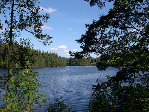
Lake Siljan, located in the Dalarna region of central Sweden, is the country's seventh-largest lake and a prominent feature of the Siljan Ring, a massive prehistoric impact crater. Formed approximately 377 million years ago during the Devonian period by a meteorite strike, the lake spans an area of about 354 km² when including adjacent smaller lakes like Orsasjön and Insjön, with Siljan itself covering roughly 292 km². It reaches a maximum depth of 134 meters and sits at an elevation of 161 meters above sea level, making its basin one of the deepest points in the region at 27 meters above sea level. The lake's water volume is around 42 km³, fed primarily by the Österdal River and draining into the Dal River. Known for its scenic beauty with indented wooded shores, meadows, and charming villages, Siljan is a hub for tourism, recreation, and cultural traditions, symbolizing Sweden's folk heritage. It also holds scientific interest due to its geological origins and past explorations for natural resources.
Lake Siljan, located in Dalarna County in central Sweden at
coordinates approximately 60°51′N 14°48′E, is the seventh-largest lake
in the country and a prominent feature of the region's landscape. It
serves as a central reservoir in the Dalälven river system, surrounded
by forested hills, uplands, and quaint villages, making it a picturesque
and popular tourist destination. The lake is part of a larger
hydrological network that includes adjacent bodies of water, and its
unique formation as part of an ancient impact crater adds significant
geological interest.
Physical Dimensions and Characteristics
Lake Siljan has a core surface area of about 290–293 km², expanding to
354 km² when including the connected lakes Orsasjön (to the north) and
Insjön (to the south). It stretches approximately 25–32 km in length
from northwest to southeast, with a maximum width of up to 25 km and
varying breadths from 1 to 11 km in narrower sections. The lake's
surface elevation sits at around 161 m above sea level, with a maximum
depth of 134 m and a mean depth of about 27.8 m. This results in the
basin's lowest point being roughly 27–28 m above sea level. The total
water volume is estimated at 8.1 km³, though some sources suggest
variations based on inclusion of adjacent lakes.
The lake's shape is
elongated and irregular, featuring deeply indented shores with multiple
peninsulas and bays. Notable bays include the wide Rätt Bay extending to
the northeast and the narrower Öster Bay projecting southward near
Leksand. Sollerön, a large island in the northwestern section, is a key
feature, contributing to the lake's scenic diversity.
Geological
Formation
Lake Siljan occupies the southwestern perimeter of the
Siljan Ring (Siljansringen), a massive circular geological formation
recognized as Europe's largest known impact crater (excluding those in
Russia), with an original diameter of about 52 km. This structure formed
approximately 377 million years ago during the Devonian period due to a
major meteorite impact, which deformed underlying Cambrian, Ordovician,
and Silurian sedimentary rocks rich in fossils. Over time, erosion has
shaped the crater into its current form, creating a ring-like graben (a
depressed block of land bordered by faults) partially filled with water.
The impact resulted in a high-relief landscape characterized by a
central granite dome bordered by lake basins and fractured granite in
the basin floor. Traces of methane, heavy hydrocarbons, vanadium, and
nickel are present in the surrounding soils, attributed to the crater's
geology rather than local sediments. Deposits of lead and zinc, such as
those in the Boda region, further highlight the area's mineral-rich
composition influenced by the ancient event.
Hydrology
Hydrologically, Lake Siljan receives primary inflows from the Österdal
River (Österdalälven) at Mora in the northwest and the Ore River
(Oreälven), both originating from mountainous catchments along the
Norway-Sweden border. These rivers contribute fresh water, supporting
the lake's role in the broader Dalälven watershed. The lake connects to
Orsasjön via a small river, forming an integrated system. Outflows
generally feed into the Dalälven River, influencing regional water flow.
The impact crater's fractured structure enhances groundwater
interactions, though the lake's water quality remains high, supporting
diverse aquatic life and recreational activities like fishing.
Surrounding Landscape and Human Features
The landscape around Lake
Siljan is marked by a mix of forested hills, meadows, and uplands,
creating one of Sweden's most attractive settings. The shores are deeply
indented and wooded, interspersed with open meadows and traditional
villages that reflect Dalarna's cultural heritage, often described as
"Sweden in miniature." Major settlements include Mora (the largest town
on the shore), Leksand, and Rättvik, with landmarks like Rättvik Church
overlooking the water.
Geological Formation and Ancient History
Lake Siljan's origins
trace back to one of the most dramatic events in Earth's history: a
massive meteorite impact during the Late Devonian period, approximately
377 million years ago. This cataclysmic event created the Siljan Ring, a
circular geological formation that is Europe's largest known impact
crater (excluding Russia) and ranks among the top 20 largest on Earth,
with an original diameter estimated at about 52 kilometers. The
meteorite, believed to be around 5 kilometers wide, struck what was then
a shallow sea covering sedimentary rocks up to 2.5 kilometers thick over
a Precambrian granitic basement. The immense energy release—equivalent
to billions of tons of TNT—generated shock waves that excavated a
transient crater, which then collapsed and rebounded to form a complex
structure with a central uplift and surrounding ring faults.
Diagnostic evidence of this extraterrestrial origin includes shatter
cones (striated conical fractures formed under extreme shock pressures
of 2–30 GPa) and pseudotachylite veins (glassy melts from frictional
heating along faults), which span a zone up to 30 kilometers wide. These
features, absent in volcanic or tectonic formations, were key in
confirming the impact hypothesis in the 1970s, ruling out earlier
theories of volcanic or endogenous origins. The crater's sedimentary
layers from the Cambrian, Ordovician, and Silurian periods are rich in
fossils, deformed by the blast, providing a window into ancient marine
life. Over the subsequent hundreds of millions of years, erosion
stripped away much of the original ejecta and rim materials, while
isostatic rebound (uplift due to the removal of overlying rock and later
glacial ice) expanded the peripheral faults, resulting in the current
ring diameter of about 75 kilometers. The lake itself occupies a
ring-like graben (depression) on the crater's southwestern side,
partially filled with water, and connects to adjacent bodies like Lake
Orsa via small rivers.
Glacial and Post-Glacial Evolution
The
Siljan region's landscape was profoundly shaped by multiple ice ages,
particularly the Quaternary glaciations. During the Last Glacial Maximum
(around 20,000–15,000 years ago), the Scandinavian Ice Sheet covered the
area, scouring the crater and depositing till and other sediments.
Deglaciation began around 11,000–10,000 years ago as the ice retreated
northward, leading to the formation of proglacial lakes and dynamic
water level changes. Sediment records from the lake bottom reveal a
sequence of varved clays (annual layers from meltwater) transitioning to
gyttja (organic-rich mud), indicating a shift from glacial to
post-glacial environments.
By around 9,500 years ago, the Siljan
Basin was connected to the ancestral Baltic Sea (then the Yoldia Sea
stage), but differential isostatic uplift—faster in the north—caused
shallowing and eventual isolation from the Baltic around 8,000–7,000
years ago. This uplift, combined with erosion, exposed deeper crustal
levels and created the lake's current morphology, with a maximum depth
of 134 meters and indented, wooded shores. Pollen analysis from cores
shows vegetation recovery, from tundra to birch-pine forests, and
eventually the mixed coniferous-deciduous woods seen today. These
changes also influenced local hydrology, integrating Siljan into the
Dalälven river system.
Prehistoric Human Settlement
Human
presence around Lake Siljan dates back to the Mesolithic period (around
8,000–4,000 BCE), as hunter-gatherers followed retreating glaciers into
the fertile valleys. Archaeological evidence, including stone tools and
settlement traces, indicates early exploitation of the lake's resources
for fishing and foraging. By the Neolithic (4,000–1,700 BCE), farming
communities emerged, introducing agriculture and animal husbandry,
supported by the region's post-glacial soils.
The Bronze Age
(1,700–500 BCE) and Iron Age (500 BCE–800 CE) saw increased activity,
with hillforts and burial mounds dotting the landscape, reflecting trade
networks along the waterways. The lake's strategic position facilitated
connections between inland Sweden and coastal areas.
Viking Age
and Medieval Period
The Viking Age (800–1050 CE) marks a vibrant
chapter in Siljan's history. Sollerön, the largest island in the lake,
hosts two major burial grounds from the late Viking period, discovered
in 2022, containing weapons, domestic items, horse harnesses, and over
100 graves. These sites suggest a prosperous community involved in
trade, farming, and possibly raids, with artifacts linking to broader
Scandinavian networks. The lake served as a transportation hub, with
boats navigating its waters for commerce in furs, iron, and timber.
In the medieval era (1050–1500 CE), Christianity spread, evidenced by
churches like Rättvik Church overlooking the lake. The region became
part of the Swedish kingdom, with villages like Mora, Rättvik, and
Leksand developing around the shores. Mining in nearby Falun (part of
the broader Dalarna area) boomed from the 13th century, influencing
Siljan's economy through trade routes. Folklore from this time,
including tales of mythical creatures like trolls and water spirits,
drew inspiration from the lake's mysterious crater origins, embedding it
in Swedish cultural narratives.
Modern History and Scientific
Discoveries
The 16th–18th centuries saw Dalarna's role in Swedish
history intensify. King Gustav Vasa, during the Swedish War of
Liberation (1521–1523), rallied support in the region; the Battle of
Falun in 1521 was a key early conflict, and Vasa famously escaped
capture in Falun. Peasant uprisings, like the Dalarna Rebellions (1743),
highlighted social tensions in this rural heartland.
The lake's
cosmic origins remained unknown until the late 1960s, when drill cores
from deep borings (part of hydrocarbon exploration inspired by Thomas
Gold's abiogenic oil theory) revealed shocked rocks, confirming the
impact crater. This sparked global interest, leading to studies on deep
biosphere microbes—methane-producing bacteria found kilometers
underground in 2019, thriving in fracture zones created by the impact.
Although no commercial oil was found, the site advanced research on
extraterrestrial impacts and subsurface life.
In the 19th–20th
centuries, industrialization brought hydropower development on the
outflows, while tourism boomed, drawn to the "Sweden in miniature"
moniker for its forests, mountains, and traditional culture. Midsummer
festivals, folk music, and crafts like the Dala horse became icons. In
2019, the area was designated a Geopark, emphasizing its
380-million-year geological heritage. Today, Siljan supports recreation,
fishing, and drinking water for communities, while preserving its blend
of natural wonder and human legacy.
Sweden's stringent environmental regulations have maintained high water quality in Siljan, making it one of the country's cleanest lakes. The ecosystem supports diverse flora and fauna, with surrounding forests hosting species like birch, pine, and wildlife including moose and birds. Aquatic life includes fish such as pike, perch, and trout, supporting recreational fishing and ice fishing in winter. Sediment records from the lake reveal post-deglaciation dynamics, with organic layers indicating historical vegetation and climate shifts. The area's biodiversity is enhanced by its protected status, though ongoing studies monitor potential impacts from historical mining and modern tourism.
Lake Siljan embodies Sweden's cultural soul, with red cottages, folk costumes, and Dala horses as national icons. Towns like Mora host the Zorn Museum, dedicated to artist Anders Zorn, while Rättvik features the 600-meter Långbryggan pier for scenic walks. Traditional church boat races, where crews in folk attire row long wooden vessels, highlight summer festivals. The region inspired composer Hugo Alfvén's "Midsummer Vigil," capturing its atmospheric beauty. Economically, tourism drives the area, with activities like steamship tours on M/S Gustaf Wasa, hiking, and visits to sites like Dalhalla amphitheater—a limestone quarry venue near the lake hosting concerts by artists like Björk. Folklore and traditions, including Midsummer celebrations, reinforce its status as Dalarna's heart, attracting visitors for relaxation and cultural immersion.
Today, Lake Siljan remains a vital ecological and recreational resource, with ongoing scientific research into its impact crater geology, including noble gas studies and hydrocarbon potential. Environmental monitoring ensures water quality amid tourism growth, while cultural preservation efforts maintain traditions like folk art and festivals. Recent social media highlights its scenic allure and venues like Dalhalla, underscoring its enduring appeal as a destination for nature, history, and culture in 2025.