Location: Norrbotten County
Area: 493 sq km (191 sq mi)
Established: 1942
Muddus National Park, also known as Muttos in the Sami language, is one of Sweden's 30 national parks and the largest forested one, spanning 493 square kilometers in the heart of Swedish Lapland. Located primarily in Gällivare Municipality in Norrbotten County, northern Sweden, it forms part of the expansive Laponia UNESCO World Heritage Site, recognized since 1996 for its outstanding natural and cultural values. The park is a pristine taiga ecosystem characterized by ancient pine forests, vast mires, deep ravines, roaring waterfalls, and low mountains, offering a glimpse into untouched wilderness. It holds significant cultural importance to the indigenous Sami people, who have used the area for reindeer herding for centuries. Established to protect its primeval forests and biodiversity, Muddus attracts nature enthusiasts seeking solitude and immersion in boreal landscapes, with visitor numbers remaining low due to its remote location near Jokkmokk.
Muddus National Park (Swedish: Muddus nationalpark; Lule Sámi:
Muttos) is Sweden’s largest forest national park and one of the
country’s most significant protected boreal wilderness areas. It
covers approximately 493–511 km² (sources vary slightly on exact
figures due to boundary refinements) in Norrbotten County, northern
Sweden, straddling the municipalities of Gällivare and Jokkmokk,
just north of the Arctic Circle in the heart of Swedish Lapland. The
park lies within the northern taiga zone, dominated by vast
old-growth coniferous forests (about 53% of the area), extensive
mires and aapa bogs (nearly half the park), deep ravines, canyons,
waterfalls (most famously the 42-metre Muddusfallet), shallow lakes,
and low, conical mountains. It forms the easternmost and
lowest-elevation section of the UNESCO World Heritage-listed
Laponian Area (Laponia), designated in 1996 for both its outstanding
natural values and the living cultural heritage of the indigenous
Sámi people.
Prehistory and Natural Landscape Formation
The area has been shaped by natural processes for millennia. After
the last Ice Age glaciers retreated around 10,000 years ago,
hunter-gatherer peoples moved into the valleys and used strategic
locations for reindeer trapping. Forest fires have been a recurring
natural force: detailed dendrochronological studies of fire scars on
living Scots pines (Pinus sylvestris) and charcoal in soil layers
document 47 fire years between 1413 and the present. Fires typically
burn small patches (1–2% of the forest at a time) every 81–110 years
on average in pine-dominated areas, creating a mosaic of
regeneration stages. Sweden’s oldest known pine tree—estimated at
over 710 years old—grows here; it survived the 1413 fire and several
others.
These dynamic processes have produced the park’s iconic
primeval forest: tall, multi-aged pines and Siberian spruce (Picea
obovata), with birch, aspen, and willow in wetter spots. The mires
(called áhpe in Sámi, evoking “ocean”) are a mix of ombrotrophic
bogs and rich fens, supporting diverse bryophytes and wetland birds.
The landscape’s inaccessibility—ravines and bogs made timber
extraction difficult—helped preserve its virgin character into the
20th century.
Indigenous Sámi Use and Cultural Significance
Long before European conservation ideas arrived, the region was (and
remains) Sámi territory. The Sámi have inhabited the area
continuously since post-glacial times, initially as hunter-gatherers
using trapping pits for wild reindeer and later developing nomadic
and forest reindeer herding. Archaeological evidence includes
ancient paths, stone-ringed hearths from lávvu (teepee-like
dwellings), peeled “bark trees,” and extensive systems of
reindeer-trapping pits. Several Sámi communities—such as the Sirges,
Unna Tjerusj, and Gällivare forest Sámi villages (samebyar)—have
traditionally used Muddus for seasonal grazing, calving, lichen
foraging in winter, and migration routes. The park’s forests and
wetlands still support reindeer herding today, with specific
exemptions in park regulations allowing snowmobiles and helicopters
for herding purposes.
Sámi oral traditions and storytelling draw
heavily from Muddus’s dramatic yet silent landscape—deep canyons,
roaring waterfalls, and endless mires—which inspired myths and a
rich cultural narrative. The park’s inclusion in Laponia explicitly
recognizes this living indigenous heritage alongside its natural
values.
19th-Century Settlement and Early 20th-Century
Logging Traces
Swedish colonization reached the southern fringes
in the 19th century. Limited logging occurred near the Luleälven
River valley, and a small farm operated beside Lake Muttosjávvre
(Muddusjaure) from around 1850 until 1909. These activities left
minor traces—stumps and young pine stands in the south—but were
never intensive enough to destroy the overall primeval character,
thanks to the terrain’s challenges for transport.
The Road to
Protection (1909–1942)
Sweden became the first European country
to establish national parks in 1909, creating nine areas—mostly
alpine—to safeguard “untouched” nature. By the 1920s, the Swedish
Society for Nature Conservation (Svenska Naturskyddsföreningen, SNF)
recognized that the northern taiga forests were underrepresented.
Forester and researcher Edvard Wibeck, who had extensively studied
northern Swedish forests, identified Muddus as an outstanding
candidate for a large, non-mountainous park preserving intact boreal
landscape. In 1927 he formally recommended it; by 1931 SNF
dispatched botanists Henrik Hesselman and Erik Almquist for
evaluation. Their initial report was lukewarm due to the minor
logging traces (strict “virgin-only” criteria prevailed at the
time), but Wibeck successfully argued that the impacts were
negligible and that a large-scale reserve was essential for
scientific and landscape values.
Proposals faced practical and
political hurdles. In the early 1930s, the forest Sámi Nilsson Kemi
family was relocated from Torneträsk to Muddus and built a reindeer
enclosure, felling around 2,000 trees. Wibeck flagged this as a
potential conflict; authorities rejected relocation plans, and
tensions arose (including 1937 accusations of reindeer theft). The
Royal Swedish Academy of Sciences (then responsible for parks)
studied the area into the 1940s. The 1941 parliamentary proposal
included a total hunting ban and (again rejected) Sámi relocation.
Debates highlighted competing interests: the First Chamber approved,
but the Second Chamber—led by Norrbotten Social Democrat Oscar W.
Löfgren—opposed it, citing existing parks in the county, forestry
potential, and Sámi rights. The proposal was defeated 125–59. After
minor boundary adjustments, it passed in 1942 without a new vote.
Establishment and Early Management (1942 Onward)
Muddus
National Park was officially established on 24 March 1942 (initially
~49,175 ha, making it Sweden’s third-largest park and the largest
non-alpine one). While one contemporary source highlights protection
of the then-scarce whooper swan as a motivating factor, the core
purpose was safeguarding a vast, essentially unchanged ancient
forest-and-wetland landscape for science, biodiversity, and future
generations. A small extension occurred in 1948 (some sources note a
larger southern expansion toward Lake Messaure in 1984 to reach the
current size).
The 1950s–1960s saw the Messaure dam flood areas
just outside the southern boundary. In 1967 the park (along with
Sarek and Padjelanta) received the Council of Europe’s European
Diploma for protected areas. Scientific research intensified; mire
studies dated to 1940, and fire-history plots were established at
regular intervals from the 1920s onward.
UNESCO Recognition
and Contemporary Era (1996–Present)
In 1996 Muddus became a core
component of the 9,400 km² Laponian Area World Heritage Site
(alongside Sarek, Stora Sjöfallet/Stuor Muorkke,
Padjelanta/Badjelánnda national parks and adjacent reserves). UNESCO
cited both natural integrity (Europe’s largest remaining virgin
taiga complex) and the Sámi’s ongoing traditional reindeer herding
as outstanding universal value. This triggered the “Laponia process”
(2002–2012), a groundbreaking collaborative governance model that
for the first time gave Sámi representatives full partnership in
management. The result is Laponiatjuottjudus, a joint management
body under the Swedish Environmental Protection Agency
(Naturvårdsverket). The park is also part of the EU Natura 2000
network and benefits from the Bern Convention.
Today, regulations
strictly prohibit logging, hunting, fishing, plant collection
(except berries and mushrooms), and motorized access (with Sámi
herding exemptions). Visitor infrastructure is deliberately
minimal—concentrated in the south with marked trails, boardwalks
over mires, and a handful of simple overnight cabins—to preserve
wilderness character. Annual visitation remains low (~5,000),
focused on hiking to Muddusfallet waterfall, Måskosgårsså canyon,
and birdwatching. A 2006 natural ground fire (burning ~3 km²) was
allowed to run its course, underscoring the park’s commitment to
ecological processes.
Muddus National Park (Muttos in Sámi) is Sweden’s largest forest
national park and a pristine example of untouched boreal (taiga)
landscape in the heart of Swedish Lapland. Established in 1942, it
covers approximately 493–511 km² (49,340 hectares) and forms part of
the vast Laponia UNESCO World Heritage Site (designated 1996),
alongside nearby parks like Sarek, Stora Sjöfallet, and Padjelanta.
It lies in Norrbotten County, straddling Gällivare and Jokkmokk
municipalities, roughly between the towns of Gällivare and Jokkmokk
in the lowlands east of the Scandinavian Mountains.
The park
preserves a roadless, primeval forest-and-mire mosaic that has
remained essentially unchanged by modern forestry or heavy human
intervention. It is renowned as one of Sweden’s quietest places,
with landscapes shaped by ancient geological forces, Pleistocene
glaciation, and ongoing natural processes like wildfires and peat
accumulation.
Topography and Landforms
Muddus sits on a
gently undulating plateau characteristic of the eastern
Fennoscandian Shield’s monadnock plains. Elevations range from about
165 m above sea level at the southern artificial lake (near the
Stuor Julevädno/Stora Luleälv river valley) to a maximum of 658 m at
the northern summit of Oerjemus Stubbá. The terrain divides
naturally into two main zones:
Northern section: Relatively
flat (mostly 380–440 m a.s.l.), dominated by expansive open mires
interspersed with meandering strips of forest and scattered low
fells (small, rounded hills). Some summits here rise just above the
treeline.
Southern section: Gently slopes downward toward the
Stora Luleälv river valley (a drop of roughly 200 m overall), where
the landscape becomes more dramatic. Here, ten steep-sided ravines
and canyons slice through the old-growth forests. These gorges
feature nearly vertical rock walls rising up to 100 m in places,
formed primarily by glacial meltwater erosion during and after the
last Ice Age.
The overall relief is subdued compared to the
alpine parks to the west, but the sudden depth of the southern
ravines creates striking contrasts. Ancient travel routes (including
Sami paths) follow the drier forest ridges between the wetlands, as
the mires become impassable in summer but serve as “oceans” (áhpe in
Sámi) for migration when frozen in winter.
Geology
The
bedrock consists of ancient Archaean (Precambrian) granite belonging
to the Fennoscandian Shield—one of the oldest and most stable
geological formations in Europe. This granitic substrate is overlain
by thin to moderate layers of glacial moraine (till) deposited
during the Pleistocene ice ages, along with post-glacial sediments
in lower areas. The soils are generally nutrient-poor and acidic,
which influences the vegetation. Limited limestone means relatively
species-poor flora in most places.
The deep ravines and gorges
are classic examples of fluvial-glacial erosion: meltwater from
retreating glaciers carved fractures in the granite during
deglaciation. Peatlands (mires) developed in the post-glacial period
as waterlogged depressions accumulated organic matter over
millennia. The park represents an unbroken assemblage of virtually
primeval forests and peatlands on this moraine-covered granite.
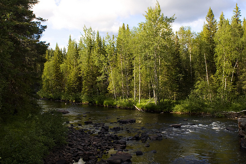
Hydrology and Water Features
Water is a defining element of
Muddus. About 2% of the park consists of lakes and ponds, while
streams and wetlands permeate the rest. The central river system is
the Muddusjokk / Muttosjåhkå / Muttosädno (Muddus River), which
drains most of the park and flows southward into the Stora Luleälv.
It creates powerful rapids, waterfalls, and dramatic canyons along
its course.
The park’s most iconic waterfall is Muddusfallet /
Muttosagahtjaldak, a 42-metre drop where the river plunges through a
steep ravine. Other notable features include the narrow Måskosgårsså
gorge and various smaller streams and lakes (e.g., Muddusjärvi,
Tjautjaure, Muttosluoppal, Rámsojávrre).
Mires and bogs cover 45%
of the area and function as vast natural sponges, filtering water
and supporting unique wetland hydrology. They range from
ombrotrophic (rain-fed) bogs to richer fens, rich in bryophytes. In
winter, these frozen wetlands become highways for reindeer and
wildlife; in summer, they remain wet and boggy, crossed only via
plankways or ridges.
Climate
Muddus lies in the northern
boreal (subarctic) zone. The climate is cold and continental, with a
mean annual temperature around 0°C and annual precipitation of
approximately 500 mm (relatively dry for northern Sweden). Winters
are long and severe, with deep snow cover; summers are short, cool,
and occasionally warm enough for thunderstorms that spark natural
fires. The park’s position in the rain shadow of the western
mountains contributes to the moderate precipitation.
Vegetation and Ecosystems
Land cover breaks down as follows: 53%
old-growth coniferous forest, 45% mire/peatland, and 2% open water.
The forests are classic northern taiga—dominated by slow-growing
Scots pine (Pinus sylvestris) and Norway spruce (Picea abies), with
some birch and aspen in wetter or disturbed spots. Many pines are
centuries old; Sweden’s oldest known pine (at least 710 years)
stands here, scarred by a 1413 forest fire. The understory features
mosses, lichens, lingonberries, and cloudberries.
The mires
support specialized bog vegetation, including sphagnum mosses,
sedges, and dwarf shrubs. Open heathlands appear on drier ridges.
The entire system is fire-dependent; natural wildfires periodically
reset patches of forest, maintaining the mosaic of age classes. The
treeline sits slightly above 600 m, so most of the park remains
forested except on the highest fells.
Muddus represents a classic boreal taiga ecosystem, with over half its area covered by ancient coniferous forests dominated by Scots pine (Pinus sylvestris), some trees aged up to 700 years with trunks over a meter in diameter. These primeval woodlands are rich in deadwood, supporting diverse fungi, lichens, and mosses, including rare species like the old-growth indicator Calypso bulbosa orchid. The vast wetlands—mires, bogs, and fens—form intricate mosaics that store significant carbon and provide habitats for specialized plants like cloudberry (Rubus chamaemorus) and sundews. Rivers and streams, unregulated and free-flowing, add dynamic elements with riparian zones hosting birch and aspen. The park's ecology is shaped by natural disturbances like forest fires, which have left charcoal layers dating back centuries, promoting regeneration. As part of Laponia, it contributes to global biodiversity conservation, with minimal human intervention allowing natural processes to prevail.
The park's remote and undisturbed habitats support a rich array of wildlife typical of the Scandinavian taiga. Large mammals include brown bears, Eurasian lynx, wolverines, moose, and reindeer, with the latter managed by Sami herders. Birdlife is abundant, featuring species like the Siberian jay, black grouse, capercaillie, and raptors such as golden eagles and rough-legged buzzards. Wetlands attract waders like ruff and wood sandpiper, while observation towers facilitate birdwatching. Smaller creatures, including pine martens, red squirrels, and lemmings, thrive in the forests, alongside insects like the rare Apollo butterfly. The ecosystem's health is evident in the presence of apex predators, though sightings are rare due to the animals' elusive nature. Conservation efforts focus on maintaining connectivity with surrounding wilderness areas to support migration and genetic diversity.
Key attractions include the iconic Muddusfallet waterfall, a 42-meter cascade plunging into a deep gorge, accessible via a 9 km loop trail from the southern entrance. Other highlights are the Muttosluoppal birdwatching tower overlooking vast mires, ancient fire-scarred pines, and scenic viewpoints along ravines. Hiking is the primary activity, with 50 km of marked trails ranging from easy 2 km paths to multi-day treks; popular routes include the 14 km trail to Måskosgårsså cabin. In winter, cross-country skiing and snowshoeing are possible on ungroomed trails. Packrafting on rivers like Muddusjåhkå offers adventurous exploration, while guided Sami cultural tours provide insights into traditional herding. Regulations prohibit camping in core zones, fires outside designated areas, and motorized vehicles to minimize impact. The park's silence and solitude are often cited as its greatest draws, ideal for mindfulness and photography.
As of 2025, Muddus National Park remains fully operational and accessible year-round, managed by the Swedish Environmental Protection Agency in collaboration with Sami communities. Recent updates include improved trail signage and digital resources for visitors, with ongoing monitoring of climate change impacts like thawing permafrost affecting mires. The park continues to support sustainable reindeer herding, balancing conservation with cultural practices. Visitor facilities are basic, including information boards, cabins, and pit toilets, with no entrance fees. Efforts to promote eco-tourism emphasize low-impact visits, and the park's inclusion in Laponia ensures international oversight for preservation. Recent travel guides from 2024 highlight its appeal for autumn foliage hikes and winter aurora viewing, underscoring its enduring status as a hidden gem in Swedish Lapland.