Location: Norrbotten County Map
Area: 1,970 km2 (760 sq mi)
Info: 0920 96200
Sarek National Park (Sareks nationalpark), located in the
Jokkmokk Municipality of Norrbotten County in Swedish Lapland
(northern Sweden), is one of Europe's oldest and most iconic
national parks. Covering approximately 1,970 km² (about 760 sq mi),
it forms a roughly circular high-alpine wilderness in the heart of
the Scandinavian Mountains (Caledonides), featuring dramatic glacial
valleys, over 100 glaciers, six of Sweden's 13 peaks exceeding 2,000
meters (including the park's highest, Sarektjåkkå at 2,089 m),
raging rivers like the Rapaätno (Rapa River), and vast untouched
tundra. Adjacent to Stora Sjöfallet National Park (north) and
Padjelanta National Park (west), it is often called "Europe's last
great wilderness" due to its remoteness—no roads, few marked trails,
and minimal infrastructure—making it a haven for experienced hikers,
climbers, and skiers.
Its history spans thousands of years of
human-nature interaction, from indigenous Sámi (Saami) stewardship
to early scientific exploration, pioneering conservation efforts,
and modern recognition as part of a UNESCO World Heritage Site.
Below is a chronological, in-depth account drawn from official
records, scientific histories, and cultural documentation.
Prehistoric and Indigenous Sámi Presence (c. 8,000 years ago to 19th
century)
Human presence in the Sarek region dates back to around
8,000 years ago, following the retreat of post-glacial inland seas. The
area's first inhabitants were nomadic hunter-gatherers—likely ancestors
of the Sámi people—who subsisted primarily on wild reindeer in this
Arctic/sub-Arctic landscape. Archaeological evidence includes hearths,
house foundations, and other traces from 6,000–7,000 years ago.
The
Sámi (also spelled Sámi or Saami), indigenous to Sápmi (spanning
northern Norway, Sweden, Finland, and Russia's Kola Peninsula),
transitioned over millennia from hunting wild reindeer to
semi-domesticated herding. By about 2,000 years ago, reindeer
domestication began, evolving into a sophisticated transhumance system
by the 16th–17th centuries: seasonal migrations between winter pastures
on the forested plains and summer grazing in the high mountains. Sarek
served as a vital corridor and grazing ground (e.g., prairies like
Skarja and Peilavalta), with Sámi families from communities such as
Sirkas, Jåhkågaskka, and Tuorpons building temporary huts (kåta) for
shelter during journeys. Reindeer provided milk, meat, hides, transport,
and cultural identity.
The mountains held deep spiritual significance
in traditional Sámi animism. Peaks and rock formations were often sieidi
(sacred sites of worship), where offerings like reindeer antlers were
made to land spirits. One prominent example is at the foot of Mount
Skierfe (1,179 m) at the entrance to the Rapa Valley, a gathering place
for regional Sámi ceremonies. Legends persist, such as Mount Apär being
haunted by demons or the ghost of an illegitimate child. Place names
throughout the park derive from Sámi languages (e.g., tjåkkå for
mountain, vagge for valley, jåkkå for stream), many of which remain
official today.
In the 17th century, Swedish colonial expansion
reached Sápmi. The Swedish Crown asserted control, imposing taxes,
evangelizing Sámi (building churches and markets at winter sites), and
attempting to exploit mineral resources. A notable but unprofitable
venture was the Alkavare silver mine (operated 1672–1702), revealed by a
local Sámi; its ruins (including buildings and a chapel) still stand in
the park. Sámi were often reluctant to assist in prospecting due to
fears of forced labor, and the mountains were generally viewed by Swedes
as dangerous and inaccessible.
Early European Exploration and
Scientific Interest (18th–19th centuries)
Systematic European
documentation began in the 18th century. Botanist Carl von Linné
(Linnaeus) traversed parts of Lapland in 1732 during his famous
expedition, though he did not deeply penetrate Sarek's core. Mapping
efforts intensified in the 19th century: Swedish surveyor Gustaf Wilhelm
Bucht mapped the region in 1870, and French explorer Charles Rabot
achieved the first ascent of Sarektjåkkå in 1881.
The late 19th
century marked a turning point with geologist and glaciologist Axel
Hamberg (1863–1931), whose work transformed public and scientific
awareness of Sarek. Inspired by his participation in Adolf Erik
Nordenskiöld's Greenland expedition, Hamberg began intensive studies of
Sarek's glaciers in 1895, continuing until his death. He produced the
first high-quality topographic map of the area, documented glacial
processes (U-shaped valleys, moraines, talus slopes, drumlins, and
erratic boulders), and built the Pårte research station (early 1900s)
with materials porter-carried in. Hamberg's publications, including
descriptions of the "joy of Swedish Lapland," popularized the region.
The Swedish Tourist Association (STF) first highlighted Sarek as a
potential site in 1886.
Establishment as a National Park (1909)
The global national park movement, sparked by Yellowstone (USA, 1872),
inspired Swedish conservationists. Polar explorer and scientist Adolf
Erik Nordenskiöld proposed protecting Sweden's wilderness areas in 1880.
Hamberg, Nordenskiöld, and others lobbied botanist and Riksdag
(parliament) member Karl Starbäck, who formally proposed the idea. On 24
May 1909, the Swedish Parliament passed the National Parks Act and
established nine parks—the first in Europe—including Sarek and its
neighbor Stora Sjöfallet. Sarek officially became a national park in
1910 (some sources cite the parliamentary decision as the establishment
year). The stated purpose, per official protocols, was "to preserve a
high mountain landscape in its natural state" for science and tourism,
shielding it from exploitation amid growing industrialization.
The
government acquired the land (99% state-owned today), administered
initially by what became the Swedish Environmental Protection Agency
(Naturvårdsverket). Unlike later parks, initial establishment involved
minimal Sámi consultation.
Early 20th Century: Management,
Threats, and the "Sarek Peace" (1910s–1960s)
In its first decades,
Sarek remained largely pristine but faced emerging threats from
hydropower development. In 1919, Stora Sjöfallet National Park lost
nearly a third of its area to a dam and reservoir on the Stora Lule
River—the first permitted encroachment on a Swedish national park.
Visitor numbers stayed low (a few dozen annually until the 1960s), but
awareness grew. Diplomat Dag Hammarskjöld famously called Sarek "vår
sista stora vildmark" ("our last great wilderness") in 1946, urging
low-impact tourism.
Mid-century hydroelectric plans threatened
Sarek's rivers. In 1961, an accord known as the "Sarek peace" (Freden i
Sarek) was reached between conservationists, the government, and energy
interests. It halted developments in Sarek, protected certain rivers as
"national rivers," and led to the creation of Padjelanta National Park
(west of Sarek) as additional safeguarded wilderness. This compromise
preserved the park's integrity while allowing limited hydropower
elsewhere.
Tourism gradually increased, aided by Edvin Nilsson's 1970
book, which boosted annual visitors from hundreds to about 2,000 by
1971. Overcrowding emerged in popular areas like the Rapa Valley,
prompting calls for regulated, environmentally sensitive access.
Late 20th Century–Present: UNESCO Recognition, Co-Management, and
Ongoing Challenges (1980s–2020s)
In 1982, the International Union for
Conservation of Nature (IUCN) placed a vast zone including Sarek on its
tentative World Heritage list. This culminated in 1996 when Sarek became
part of the Laponian Area (Laponia), a 9,400 km² UNESCO World Heritage
Site inscribed under mixed cultural and natural criteria. It recognizes:
Natural values (vii–ix): Outstanding glacial geomorphology,
biodiversity, and processes in Sarek's mountains, valleys, and the
adjacent Sjaunja mire (Europe's largest outside Russia).
Cultural
values (iii, v): One of the largest remaining examples of Sámi reindeer
transhumance and traditional land use, reflecting an ancestral way of
life dating back centuries.
Laponia includes Sarek, Padjelanta,
Stora Sjöfallet, Muddus, and reserves. Since 2011, management involves
the Laponiatjuottjudus Association (Sámi-majority body) for
consensus-based decisions with Sámi communities, municipalities, the
County Administrative Board, and the Environmental Protection Agency—the
first major inclusion of Sámi voices (unlike 1909). The park joined the
EU's Natura 2000 network, and a 2007 plan proposed (but did not fully
implement) expansions like the Laitaure Delta.
Today, Sarek retains
strict protections: no fishing, hunting (except limited Sámi rights),
flower-picking, or motorized vehicles for non-Sámi. Sámi herders retain
full rights to reindeer husbandry, including motorized transport for
herding. Annual visitors number around 8,000, drawn by its trail-less
wilderness, but challenges persist: climate change is causing glaciers
to retreat rapidly (some estimates ~1.5 m/year in places),
snowmobile/ATV damage to tundra, conflicts between predators (wolves,
bears) and reindeer herds, and balancing tourism with conservation.
Sarek National Park is one of Europe’s most pristine and dramatic
wilderness areas, located in Jokkmokk Municipality, Norrbotten County,
in Swedish Lapland (northern Sweden), just north of the Arctic Circle at
approximately 67°17′N 17°42′E. It lies about 50 km from the Norwegian
border and forms part of the vast Laponia UNESCO World Heritage Site
alongside neighboring national parks.
The park covers roughly
1,970–1,977 km² (about 760 sq mi) in a nearly symmetrical circular shape
with an average diameter of ~50 km. It adjoins Stora Sjöfallet National
Park to the north and Padjelanta National Park to the west, creating a
combined protected high-mountain zone of around 5,500 km². Established
in 1909, it is one of Sweden’s oldest national parks and is renowned for
its roadless, trail-less character—emphasizing its status as one of
Europe’s last true wildernesses.
Topography: Mountains, Valleys,
and Plateaus
Sarek is Sweden’s most mountainous region and the area
that most closely resembles an alpine landscape. Its terrain consists of
three interlocking types: massive mountains, large U-shaped valleys, and
high plateaus—often hard to distinguish from one another due to their
dramatic scale.
Mountains and Peaks: The park contains
approximately 200 mountains exceeding 1,800 m (5,900 ft) in elevation,
of which 82 are named. It includes 6 of Sweden’s 13 peaks above 2,000 m
(6,600 ft), with 19 summits over 1,900 m. The highest is Sarektjåkkå
(Sarektjakka), at 2,089 m (Stortoppen summit)—the second-highest
mountain in Sweden after Kebnekaise. Its massif features multiple
summits (e.g., Nordtoppen 2,056 m, Sydtoppen 2,023 m, Buchttoppen 2,010
m) with steep, glaciated faces and sharp ridges. Other prominent peaks
include Pårte (Pårtetjåkkå, 2,005 m), Piellorieppe (Kåtokkaskatjåkkå,
1,978 m), Ålkatj (Akkatjåkko, 1,974 m), Äpar (1,914 m), and Skårki
(1,842 m). Elevations range from valley floors around 477–500 m (e.g.,
near Lake Rittakjaure in the southwest) to these soaring summits,
creating razor-sharp ridges, cirques, and horns sculpted by ice.
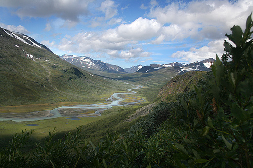
Valleys: Deep, glacially carved U-shaped valleys dominate the lower
terrain. The largest and most iconic is the Rapa Valley
(Rapadalen/Ráhpavuobme), covering about 40 km² with several branches:
Sarvesvagge (extending toward Padjelanta), Kuopervagge (~20 km²), and
Ruotesvagge (ringed by glaciers on the Sarektjåkkå massif). Other
notable valleys include Kukkesvagge (along the northeastern border) and
Njåtsosvagge (near the southern edge). These valleys feature steep
walls, braided river systems, and lush contrasts to the barren heights.
Plateaus: High, relatively flat areas provide expansive views. The
Luottolako plateau (west of the Pårte massif) spans 45 km² at
1,200–1,400 m. The Ivarlako plateau (east of Pårte) sits lower at
660–850 m. These plateaus are dotted with alpine tundra, moors, and
scattered lakes.
Glaciers and Glacial Sculpting
Sarek hosts
nearly 100 glaciers (one of Sweden’s richest concentrations), covering
roughly 100 km². These range from small ice patches to larger valley
glaciers. The biggest is Pårtejekna (~11 km² on the Pårte massif);
others include Mikka (~8 km²). Many cling to north- and east-facing
slopes of the high peaks. Pleistocene and more recent Quaternary
glaciations carved the park’s signature features—U-shaped valleys,
cirques, sharp arêtes, and moraines—while resistant rock formations
(like ancient diabase/diorite dikes) created jagged zones. Glaciers
continue to shape the landscape today, though many are retreating due to
climate change (with some historical advances linked to increased winter
precipitation).
Hydrology: Rivers, Deltas, and Lakes
The
park’s hydrology is dominated by the Rapa River (Rapaätno/Rápá), which
drains much of the area. It originates from ~30 glaciers on the
Sarektjåkkå massif, flows ~35 km through Rapadalen, and empties into
Lake Laitaure (outside the park but fed by it), eventually joining the
Lesser Lule River system. The river carries massive sediment loads (up
to 5,000–10,000 metric tons daily in summer from glacial silt), giving
it a distinctive grey-green color and creating one of Europe’s most
spectacular braided deltas—Rapaselet (nearly 10 km long) and the famed
Laitaure delta. Seasonal flows are extreme: ~30 m³/s average, peaking at
100 m³/s in July and dropping to ~4 m³/s in winter. Other rivers follow
major valleys and feed into the Lule River basin; northern ones drain
toward Lake Akkajaure. Lakes include Alkajaure (751 m, on the Padjelanta
border) and Pierikjaure (820 m). The park receives some of Sweden’s
highest precipitation, making streams turbulent and hazardous.
Geology and Landscape Formation
Geologically, Sarek belongs to the
Scandinavian Mountains (Caledonides), formed during the Caledonian
orogeny (~450–250 million years ago) when the Laurentia and Baltica
plates collided. This created thrust nappes of deformed rocks over older
Precambrian basement. Later uplift (possibly ~60 million years ago,
influenced by the Iceland hotspot and isostatic rebound from
glaciations) raised the range, which was then eroded into a peneplain
before renewed elevation. Multiple Quaternary glaciations (starting ~15
million years ago, with final deglaciation ~9,700 years ago) were the
primary sculptors: ice sheets and local glaciers excavated valleys,
sharpened peaks, and deposited moraines. Resistant features like
608-million-year-old diabase dikes (from Iapetus Ocean rifting) and the
Sarektjåkkå nappe of rift sediments created differential erosion
patterns, resulting in the park’s dramatic relief.
Overview and
Context
Sarek’s geography creates a subarctic alpine environment with
altitudinal zonation: lower valleys feature coniferous and subalpine
birch forests with meadows and wetlands; higher areas transition to
alpine tundra, mountain moor, bedrock, and shingle (roughly 43% moor,
38% bare rock, 15% meadows, plus glaciers and birch forest). The lack of
infrastructure preserves its raw character—hikers must ford rivers,
navigate bogs, and cope with rapidly changing weather (rain, wind,
sudden snow even in summer).
The park's ecology spans alpine tundra, birch forests, and wetlands, supporting a resilient subarctic ecosystem adapted to extreme conditions. Vegetation is diverse, with low-lying shrubs like dwarf birch and willow in valleys, alpine meadows blooming with wildflowers such as globe flowers and mountain avens in summer, and lichen-covered rocks on higher plateaus. Rivers and deltas foster riparian habitats rich in sedges and grasses, while mires and bogs act as carbon sinks. The absence of human infrastructure allows natural processes like wildfires and avalanches to shape the environment, promoting biodiversity. As part of Laponia, Sarek contributes to global conservation efforts, with ongoing monitoring of climate impacts, such as permafrost thaw affecting soil stability and plant distribution.
Sarek is a haven for Scandinavian wildlife, hosting large mammals such as brown bears, wolves, wolverines, lynx, and moose, which roam freely in its remote expanses. Reindeer, managed by Sami herders, are abundant, migrating through valleys. Bird species include golden eagles, gyrfalcons, ptarmigans, and rough-legged buzzards, with wetlands attracting waders like red-necked phalaropes. Smaller animals, such as Arctic foxes and lemmings, thrive in the tundra, while rivers support fish like Arctic char. The park's predator-prey dynamics remain intact due to low human disturbance, though climate change poses threats to species like the wolverine, dependent on snow cover. Sightings are common for patient observers, emphasizing Sarek's role as a biodiversity hotspot.
Key attractions include the Rapa Valley with its meandering river and delta landscapes, the piercing peaks of the Sarek massif for climbing, and glacial hikes to viewpoints like Skierfe for panoramic vistas. Hiking is the primary activity, with unmarked trails demanding navigation skills; popular routes include the Kungsleden trail skirting the edges and multi-day traverses through valleys like Alkavagge. Mountaineering targets summits like Sarektjåkkå, while packrafting on rivers offers adventurous exploration. Winter activities encompass ski touring and snowshoeing amid aurora borealis. Sami cultural experiences, such as guided reindeer herding tours, provide educational insights. Regulations prohibit fires, camping in sensitive areas, and drones to protect the environment, with visitors advised to follow "leave no trace" principles.
As of 2025, Sarek National Park remains fully protected and accessible, managed by the Swedish Environmental Protection Agency in partnership with Sami communities to balance conservation and traditional land use. Visitor numbers are moderate, around 2,000-3,000 annually, due to its remoteness, with no major infrastructure changes. Ongoing challenges include accelerating glacier melt from climate change, prompting research initiatives on ecosystem resilience. The park is open year-round, but summer (July-August) is peak season for hiking, with permits not required but safety registrations recommended. Recent efforts focus on sustainable tourism, including digital trail apps and environmental education, ensuring Sarek's wilderness endures as a symbol of untouched nature.